Excavations on the line of the Antonine Wall, 2024
Introduction
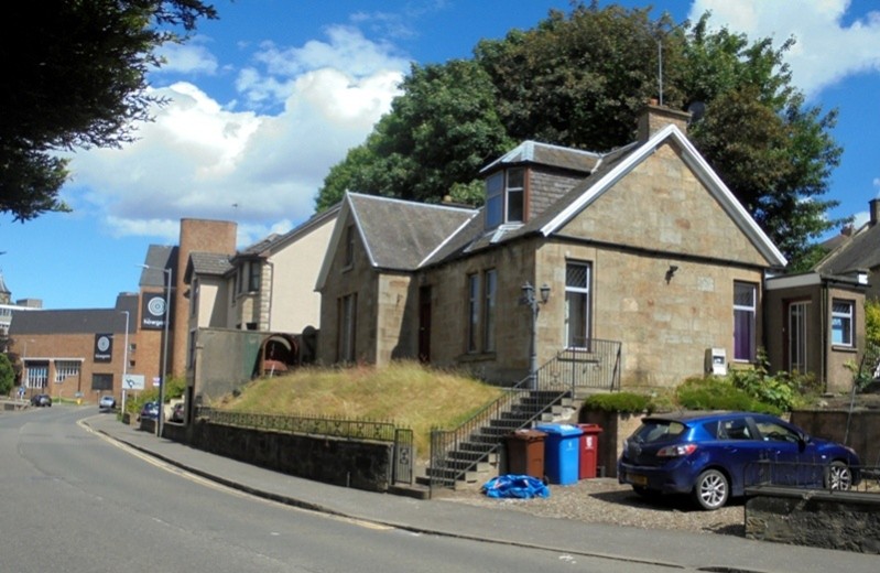
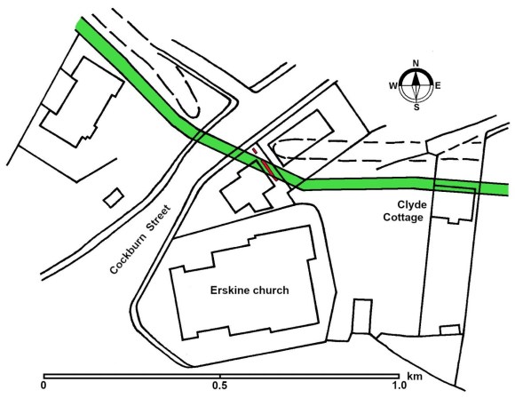
The line of the Antonine Wall where it crosses the West Burn of Falkirk was determined in 1989 (Bailey 1996) some 30m or so to the south of the previously assigned line and subsequent investigation further east at Clyde Cottage has refined the line in that area (Bailey 2021, 463-478). Consequently the Ordnance Survey amended its maps. The new line placed the Rampart of the Roman frontier under the north gable of 109 Cockburn Street (NS 8852 7980) and it was this line that was adopted for the World Heritage Site in 2008. So, when proposals were made in 2021 to redevelop the site it was necessary to determine if any Roman levels survived within its curtilage, and if so, where. The confined nature of the site and the steep gradients in and around the cottage caused significant delays to the commencement of the archaeological work with several commercial units pulling out. In the event, one day’s excavation by the author and his team on 8 July 2024 was sufficient to make a preliminary assessment of the nature of the Roman stratigraphy.
Excavation
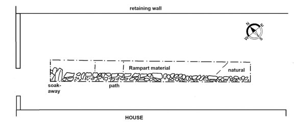
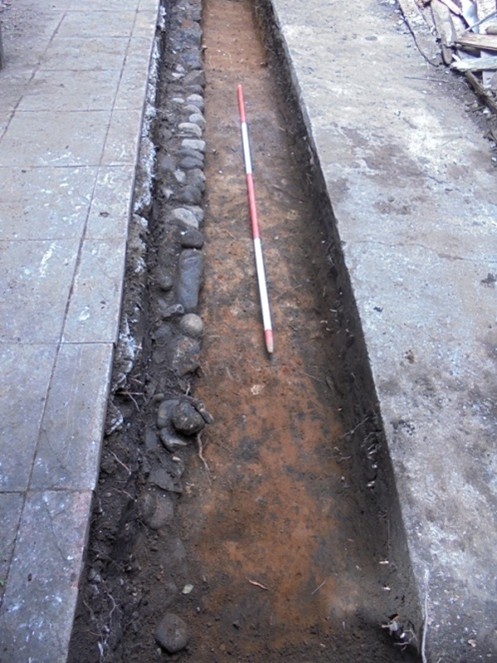
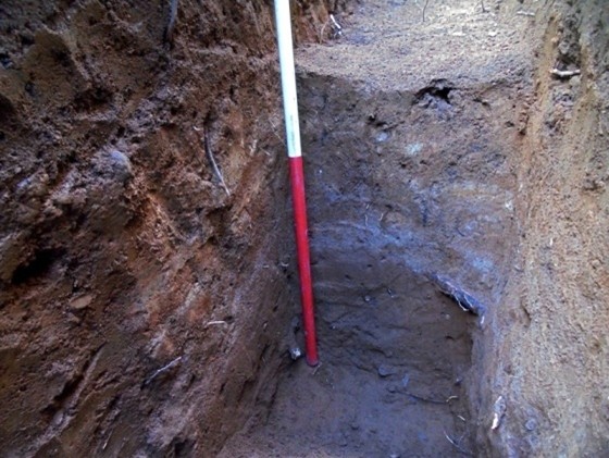
Trench 1 was 6.7m long but only 0.7m wide and was placed 0.9m to the east of the east gable of 109 Cockburn Street. Its size and location was determined by the presence of a cast concrete floor and paving slabs (as can be seen on the photographs). Fortunately the modern deposits proved to be shallow and a cobble path occurred at a depth of 0.25-0.3m below the concrete. It ran parallel with the house with which it was intimately associated and extended 0.2-0.3m into the trench. The southern 3m (F4) consisted of small round cobbles with those along the eastern edge neatly aligned to form a kerb. The northern section (F5) of the path was composed of flat broken sandstone, also with a kerb. Over both sections was a thick layer of ash and clinker. The single layer of cobble stones had been laid on buff clay loam (F6) which contained some charcoal flecks and 18-19th century pottery. F6 was only 0.2m deep at the southern end of the trench but this increased to 0.45 at the northern end. Below it was an orange-brown sandy loam (F7) containing tobacco pipe stems and a few pieces of green-glazed ware. This was clearly a cultivation soil which followed the slope of the hill – its base was 0.25m below the concrete near the southern end of the trench and 0.78m at the north end.
…
F7 gave way to a bright orange sandy loam natural in the first metre of the trench, but the remainder consisted of patchy yellow, brown-orange, and grey/blue clay and clay loam (F8) representing laid turfwork. A modern disturbance was exploited to place a section through this layer which proved to be 0.43m deep at that point. At its base was the same natural as found at the south end of the trench.
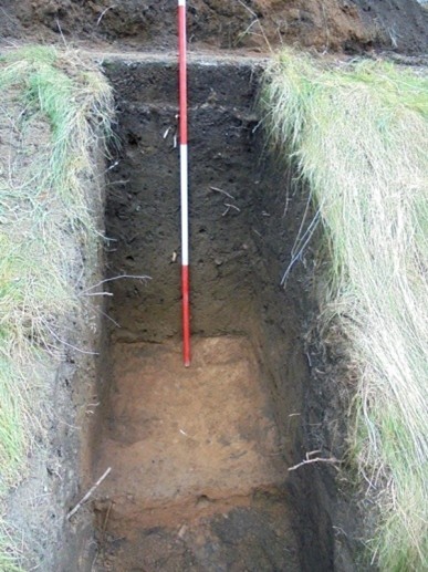
Trench 2 was excavated on the steep grassy slope between the house and Cockburn Street. This is a confined space but it was useful in determining the natural hill slope before modern terracing took place. The natural orange silty sand was discovered at the base of the trench some 1.32m below the level of the concrete at Trench 1, i.e. 0.52 below its level at the north end of Trench 1 just 2.6m to the south. On this, in the south-west corner of the trench, was a thin layer of patchy yellow and orange clay (layer 7 in the section) which may represent turf collapsed from the Rampart. Above this the thick layers were all associated with the post-medieval cultivation of the area.
…
Discussion
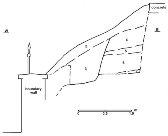
The laid turfwork of F8 is on the predicted line of the Rampart of the Antonine Wall and despite not having a stone base we can assign it to that feature. Several other examples of this occurrence are known, such as at Mary Square in Laurieston (Bailey 2002, 260-267). It is surprising that on such a hill slope a stone raft was not used. In line with planning policy for the WHS it was not sectioned and so it is not possible to be certain if stone was provided for the forward slope. Nor is it possible to give a clear indication of the cheeks, though the southern 0.35m of F8 did appear to have more clay. Soil sampling could be undertaken to determine the exact nature of this.
The southern side of the Rampart occurred in Trench 1 but the northern side was not found. The turfy material in Trench 2 may have been derived from the demolition or collapse of the Rampart, but its absence from the eastern side of that trench suggests that it may have been just beyond the line, as shown on the map above. The line of the wall does not follow the strike of the hill but runs across it at an angle to lessen the gradient. The section of the turfwork excavated suggests that it was terraced into the lateral slope, and it was also noticeable that the natural in trench 2 was relatively flat despite being considerably lower than that in Trench 1.
The survival of the Rampart in this location is remarkable. To the north it was removed in the 1930s when a petrol station was inserted requiring the terracing down of that area. The north boundary wall of 109 Cockburn Street now acts as a retaining wall with a drop of almost 3m. To the east the whole hillside was quarried away for sand in the late 19th century and then infilled with building rubble (Bailey 2021, 463-4). To the south the ground has been terraced down to provide a platform for the house and yard, and further south for the Erskine Church. To the west the widening of Cockburn Street in the mid 19th century took away the foot of the hill in that area. In the Roman period the hill sloped more gently down to the West Burn at this point and the stream lay just west of the Boundary wall to Highfield on the other side of the road. The stream was wide and relatively shallow and could be crossed as late as the late 19th century by a series of stepping stones. The stream flowed from south to north, taking with it the effluent from the nearby Roman fort which was conveyed to the West Burn by the Goat Burn.
Acknowledgements
The author would like to thank Gina Fyffe for her persistence in commissioning the work. He was aided in the excavation by several enthusiastic volunteers to whom fell the task of scaling the heights of the bank in front of the house and breaking through the concrete at its side. These were – Richard Gillanders, Bruce Harvey, Janet Kinniburgh, Ian McAdams and Kenny Mcleish.
Bibliography
| Bailey, G. B. | 1996a | ‘Stream Crossings on the Antonine Wall’, Proc Soc Antiq Scot, 126 (1996), 347-369. |
| Bailey, G. B. | 2002 | ‘Mary Square, Laurieston, in Dunwell, Bailey, Leslie & Smith 2002, 259-304. |
| Bailey, G. B. | 2021 | The Antonine Wall in Falkirk District. |
| Dunwell, A., Bailey, G., Leslie, A. & Smith, A | 2002 | ‘Some Excavations on the line of the Antonine Wall, 1994-2001’, Proc Soc Antiq Scot, 132 (2002), 259-304. |
