INTRODUCTION
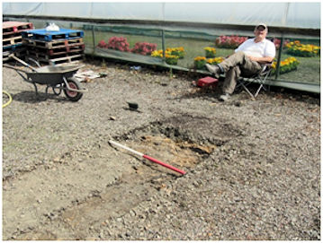
During the last week of July and the first week of August 2018 nine trenches were dug by hand to the east and south of Kinneil House and the area between the house and the first set of gate piers was surveyed using a resistivity meter in order to assess the nature of the surviving archaeology. Interest focused on two elements of the site – the 16th and 17th century designed landscapes that appeared to have involved a substantial amount of remoulding of the naturally north-facing slope, and the medieval occupation pre-dating the present house of 1552.
Part of the geophysical survey had been conducted in November 2017 by the Edinburgh Archaeological Field Society and it had been hoped to complete this the week before the dig took place. In the event the prolonged hot spell and the associated drought meant that it was not possible to make a reliable electrical contact with the lower soil horizons and consequently the survey was only completed on the last day of the dig. It produced some interesting results which will be discussed towards the end of this paper and which it is hoped will be explored on the ground at a later date.
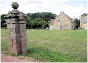
Kinneil House lies on the western edge of modern Bo’ness on the south side of the Forth Estuary (NS 983 806) and was constructed for the 2nd Earl of Arran when he was regent of Scotland during Mary Queen of Scots’ early years. The house displayed the latest design developments in courtly architecture – the bulky viewing platform, the duplicated three-room processional audience suite for husband and wife, the massive glimmering white facade broken by few window apertures, the magnificent coat-of-arms, and so on. We should therefore expect that the grounds would have been equally ground-breaking and technically proficient.
EXCAVATION
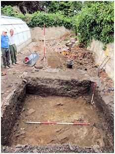
Trench A
Illus 2: Trench A looking west with Kinneil House in the background.
The first trench was placed in the Orchard to the north of the main avenue. The Orchard forms a discrete level compartment within the designed landscape and is surrounded on three sides by boundary walls over 8ft tall. The wall on the fourth side was raised in height in 1611 to form the back wall of a coach house and stable. The W/E trench was 5.0m long by 1.6m wide and bottomed onto speckled orange loamy clay throughout at a depth of 0.4m. Below the 0.1m of clean black topsoil (F2) was a 0.05m thick layer of dark brown loam containing a large amount of speckled white mortar, tile and small angular pieces of sandstone (F3). Below this again was 0.25m of brown clay loam (F4) which contained fragments of 19th/20th century pottery as well as 19 fragments of tobacco pipe.
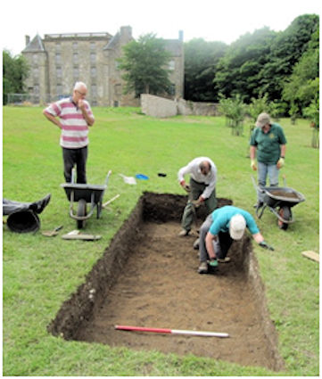
F3 can be associated with the demolition of the nearby south wall of the Orchard in the early 1960s. During the Second World War this area seems to have been planted with potatoes as part of the war effort and the deep ploughing required probably accounts for the lack of stratification below F3. The 0.4m depth is compatible with the use of the enclosure as an orchard, as is the intensive land cultivation suggested by the large amount of tobacco pipes. It is evident that the whole of the south side of the Orchard has been terraced into the north-facing hill slope. The soil was presumably disposed over the north side using the north wall as a retaining wall in order to create a level surface within the enclosure.
Trench D
Illus 4: Trench D looking SE.
This N/S trench was located north of the polytunnels in the western compartment of the walled garden which lies on the south side of the grand avenue. It was dug after Trench B where natural orange clay was found at a depth of 1.1m below the modern surface. It was therefore surprising to find that bedded sandstone bedrock lay immediately below 0.05m of pea grit at the south end of the trench. This continued north for 2.7m, beyond which the sandstone was broken and embedded in a clay matrix. At 5.8m it was interrupted by a W/E electricity cable, bounded by another modern disturbance.
At the north end of the trench, a distance of 7.1m with a drop of 0.56m in the present surface, the natural was 0.25m down.
In 1990 the walled garden became the central nursery for Falkirk Council to raise bedding plants. As part of the preparation of the site for this new role a vast amount of hardcore and pea grit was brought in to create a new surface. It is now apparent that the existing topsoil was stripped from the whole area and removed from site. The extremely shallow depth of cover indicates that there is little chance of above-ground historic structures, such as walls, surviving, except where they were placed in or over natural and artificial hollows.
Trench E
Just over 5m down the hill to the north of Trench D the natural stone in clay and bedrock appeared consistently at a depth of 0.4m, covered by 0.2m of extremely compacted black clayey soil (F5) and the same amount of hardcore/ pea grit. The trench was 3.0m long and 0.5m lower down the slope than Trench D. From the south end of Trench D to the north end of Trench E there was a fall of 1.4m.
F5 is a heavily compacted soil – all that remains of the earlier topsoil. Staff at the nursery confirmed that in 1990 the imported hardcore was consolidated by road rollers for several weeks; an unfortunate event that slowed progress on hand digging the other trenches in the walled garden.
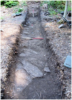
Trench F
Illus 5: Trench F looking W.
Located on the berm of the Antonine Wall, between a greenhouse and the north wall of the garden, Trench F was placed to search for berm pits as well as the nature of the 16th century terracing. It measured 2.8m W/E by 2.6m N/S, the north baulk being only 0.7m from the boundary wall. As suspected, the amount of material over the natural was greater than in Trenches D and E, but was still only 0.8m deep to the laminated bedrock. The top surface was 1.85m lower than that at the south end of Trench D. Resting directly upon the rock was a 0.05m layer of red blaes, the remainder of the overburden being good black topsoil. Along the northern margin of the trench a cut in the rock was probably the construction trench for the garden wall.
Despite the presence of almost 0.8m of topsoil it is apparent that even here the area had been stripped in the past, the natural scraped and external material added. Blaes was used prolifically by Falkirk Council on the estate in the late 1970s and early 1980s at which time the greenhouse was erected.
There were no berm pits set into the loose rock, but its horizontal surface throughout the trench and the position of the blaes show that the natural here has been truncated. Its general level does, however, reflect the continuous slope of the hill noted in Trenches D and E. The 0.8m of soil terracing up in Trench F is recent. There is now a drop of 2.4m in the ground level from the inside of the walled garden to the outside at this point. Allowing for the truncation of the bedrock and an earlier topsoil this would still have been around 2.0m in the 16th century. This shows that there was extensive terracing down of the area between the drive of the grand avenue and the walled garden and the implications of this will be examined in the discussion section, as will the observed island of natural rock that it left in this corner of the walled garden.
Trench G
Illus 6: Trench G looking east.
In order to explore the extent of this raised bedrock in the NW corner of the walled garden Trench G was placed outside the west boundary wall at right angles to it. Surface observations show that the rock possessed what appeared to be an almost vertical artificial face which starts at the engaged column just beyond the NW corner of the walled garden and diverges slightly westwards from the garden wall as it continues southward to a point roughly half way along that wall where an earth bank hides or replaces it. This divergence suggested the possibility that the cutting of this face was not directly related to the construction of the boundary wall and might even have been earlier. Indeed, the line of the cut is pretty much perpendicular to the line of the Antonine Wall and would have been ideally placed for the west side of the often proposed Roman fort placed at Kinneil on the grounds of spacing.
Trench G was 1.1m wide and commenced at the top of the slope 2.0m from the garden wall. For the first 1m there was a gentle slope down to the west in the surface of the natural which lay 0.12m below the existing ground level. Here the natural was finely laminated sandstone.
After the first 1m it sloped steeply, at an angle of around 60 degrees, descending 2.3m in height.
At the bottom of this slope the sandstone gave way to broken shale for the next 2m of the trench. Above it, worked blocks of sandstone at this break of slope were probably capping stones from the tall garden wall. The remaining 6m of Trench G were fairly level with large irregular interlocking slabs of sandstone set into a clay matrix, covered by between 0.1 and 0.4m of topsoil and leaf litter.
The steep angle of the laminated sandstone and shale support the belief that the rock face had been artificially created, though there was no positive proof in the form of chisel marks. However, further north the face is formed of solid sandstone on the same line which would not have occurred naturally. The basal sandstone had very little topsoil over it, but its flattish nature, despite the angularity of many of the sandstone blocks, hints at deliberate levelling. Here again we have evidence of the creation of a terrace, though its purpose is unclear and will be considered in the discussion section.
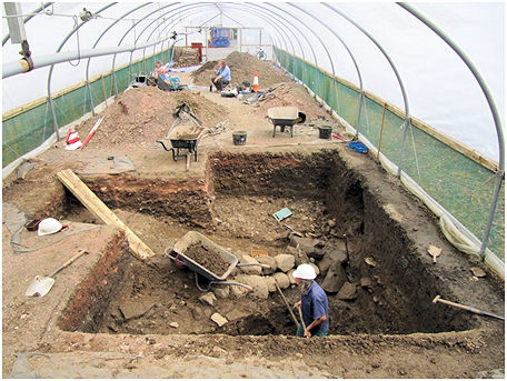
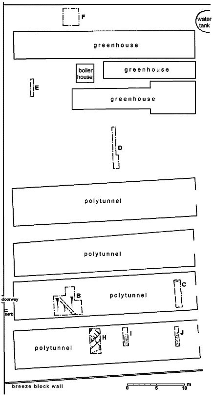
Trenches B, C, H, I & J
Five trenches were excavated within the polytunnels. B and C were in the polytunnel that had been set on line with the central W/E axis of the walled garden over an earlier path and it had been towards the extreme west end of this that the north lip of a large ditch (F10) had been discovered in 1990 (Bailey 1996, 360-3). Trench B successfully relocated the north side of this ditch slightly further to the east, but it did not continue on the same line as far as Trench C. The south side was found in Trench H, and again it failed to appear in Trenches I and J to the east.
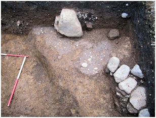
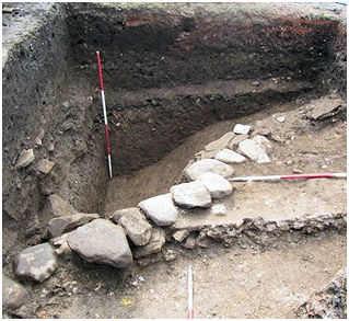
Illus 7: Metalling F12 below stone features F39 & F40. The cut for F10 can be seen on the left.
#In Trench H the ditch cut an earlier feature represented by patches of metalling (F12) made up of small multi-coloured rounded pebbles with a well rolled surface which followed the north-facing slope of the hill with a distinct W/E step at one point. The step suggests that the metalled surface, presumably a largely unworn road, ran from west to east. It lay directly upon the naturally loamy clay. Its nature and location indicate that this was the Military Way that runs along the back of the Antonine Wall.
Illus 8: Plan showing the Excavation Trenches in the Walled Garden.
F10 was massive. It measured around 10m wide and was at least 1.4m deep from the natural on the north (lower) side (2.4m from the present ground level). The curving side of the “ditch” in Trench H may represent either a butt end or a turn to the north – a slight northerly trend was detected in Trench B. Similarly, the SW/NE alignment of the north lip observed in 1990 could have been a mirroring butt end, a contraction in the width of the ditch, or a turn to the south. At that point it was only 2m away from the tall western boundary wall of the garden and it still appears that the ditch was carefully backfilled there so that the wall could be properly founded (ibid, 361-4). As the walled garden was contemporary with the house built by the second Earl of Arran when he was regent, it would mean a date earlier than 1550 for the ditch. It is therefore not surprising that it does not feature on any of the estate maps from 1708 onwards.
The lowest fill encountered in ditch F10 was a silty sand (layer 15, Sec B) showing that there had been some natural weathering of its sides whilst it was open. However, above this was a 0.4m thick deposit of orange-brown clay loam (layer 14, Sec B; layers 16 & 17, Sec H1) which extended over the lip of the ditch and which had been deliberately dumped to commence the filling of the hollow.
This layer contained a small quantity of bone, slag, a tile fragment, shell, lumps of limestone and two base sherds of green-glazed ware of 16/17th century style. The layers above this contained similar material, including a lead weight and a piece of sandstone with lime mortar attached.
The topmost fill (F30), which contained patches of flat stone on its surface indicating that it was the final phase of deliberate backfill, held slightly later types of green-glazed ware and a stem fragment of a 17th century tobacco pipe. It also had a greater quantity of bone and was evidently exposed for a longer period allowing the rubbish to collect.
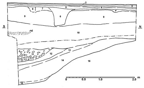
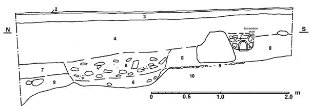
2 – pea grit; 3 – green broken whinstone and dust; 4 – red blaes; 5 – compact hard dark grey-brown clay loam and blaes; 6 – red blaes; 7 – mixed red blaes and dark grey clay loam; 8 – timber kerb & sand; 9 – dark brown clay loam with charcoal flecks & small stones; 10 – brown loamy clay with charcoal & lime; 11 – small pebbles & burnt sandstone with large voids; 12 – dark brown loamy clay; 13 – brown-orange loamy clay; 14 – brown clay loam with some charcoal & orange bands; 15 – brown-orange silty sand; 16 – brown-orange sandy clay (natural).
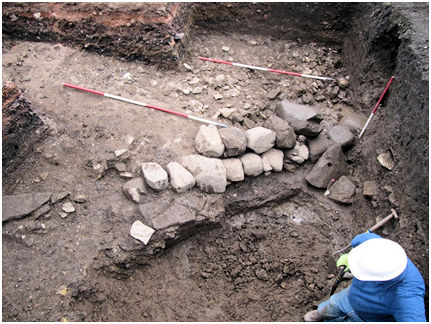
Illus 10: Ditch F10 in Trench B looking W over kerb F35.
Cut into the top of the ditch fills in Trench B was a large circular pit loosely filled with small pebbles and burnt sandstone (F31 – layer 11, Sec B). The soil around the stones was noticeably damper and siltier than elsewhere and the feature is seen as a planting pit for a tree.
A NW/SE linear arrangement of medium-sized boulders (F35) had been laid across the infilled ditch in Trench B. It consisted of two courses, the lower one protruding further west than that above showing that it buttressed material to the east. Though not dressed, the straighter sides had been aligned to form a neat edge and the gaps between the boulders had been plugged by smaller stones, which were also used as wedges to keep the larger ones upright.
Like the upper ditch fill (F30) the stone feature had slumped into the ditch as it compacted over the following decades. Two of the stones had fallen forward and were found on top of F30. One of these had a hollow socket cut on its upper surface.
Illus 11: Trench B looking east with the ditch (F10) in the foreground. The stone buttress F35 runs across the centre with the slumped socketed stone of the right. Behind is the stone raft (F22).
Towards the top of the ditch sandstone flagstones (F33) had been laid at the base of the boulders on F30, presumably to prevent erosion and to act as a drain for water running off.
To the east the boulder alignment retained a thick dump or raft of broken sandstone, many pieces of which had white lime mortar attached. It appears to have formed a low causeway across the remaining hollow of the infilled ditch.
Below F22 a single body sherd of 15/16th century oxidised green-glazed war was found. Within F22 there were small amounts of bone, oyster shells and reduced green-glazed ware; whilst a little above it was a stem fragment from a 17th century tobacco pipe. All of this suggests that the causeway path was constructed in the 16th century and continued in use for some time.
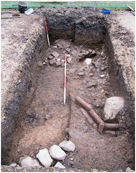
Illus 12: Trench H looking N. In the foreground is the stone alignment F39. The horseshoe drain deviated round the large boulder F40, with the rubble raft beyond (F43).
Trench H had been placed to pick up the boulder alignment (F35) on the south side of the ditch, but due to subsequent disturbance only one boulder (F40) was found on this line. It lay in the east baulk above the Roman road (F12 – Sec H2). A stone raft (F43) lay to the east of the expected kerb and is presumably a continuation of F22. Aligned with F40 was another set of smaller boulders (F39), but these were almost perpendicular to F35 and had been set just beyond the ditch. They would have formed the northern edge of a path set at just under a right angle to the causeway across the infilled ditch. Extrapolated across the whole of the walled garden these paths would have formed a network of promenades set in a lattice pattern. They meet the boundary walls at angles of 35 or 125 degrees.
The stone raft (F22) was covered by a thin layer of purple clay (F21) which had been placed to seal it in. It in turn was overlain by up to 0.7m of brown clay loam with frequent flecks of charcoal and specks of lime mortar (F34).
Although its structure had been affected by the compaction of the layers above this was clearly a cultivation soil associated with the use of the walled garden for the growing of plants. Large patches of comminuted shells (F37) occurred towards the base of F34. These were often up to 0.15m thick and in Trench H one deposit was 0.20m thick. In Trench B a large deposit of shell butted onto the south side of a dump of disintegrated red-brown sandstone (F24) which is all that remained of the early axial path before it was replaced by the 20th century blaes one. Patches of this were also found immediately above the natural on the east side of Trench C.
2 – pea grit; 3 – green angular whinstone chips; 4 – dark grey compact clay loam; 5 – medium sized angular sandstone & lime in brown clay loam; 6 – dark brown-orange clay loam; 7 – broken shell; 8 – brown clay loam; 9 pebble surface (F12); 10 – orange sandy clay loam (natural).
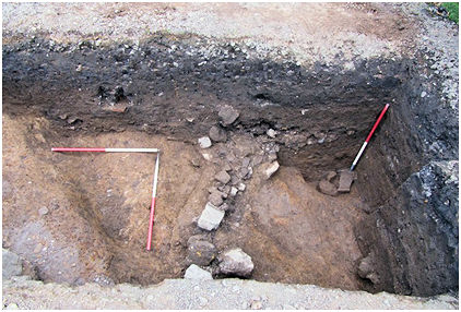
Illus 14: F42 in the ditch F10 in Trench H looking W.
Cutting diagonally across the infilled ditch and presumably the boulder alignment in Trench H was a stone filled secondary ditch (F42 – layer 12, Sec H1; layers 5 & 6, Sec H2 (not illus)). This contained a spine of larger stones at its base aligned WNW/ESE. It dipped to the west and resembles a large rumble drain. The presence of the much earlier ditch would undoubtedly have created problems with waterlogging here.
The damp problem evidently continued. Cut into the top edge of the rumble drain was a ceramic field drain surrounded by sulphurous iron slag (F50). It was of the horseshoe variety with sole plates made from the sides of broken specimens, indicating a date in the early 1840s. It had completely silted up and was no longer functioning.
Trenches I and J both contained scatterings of pebbles over their southern halves at a depth of 0.4m just above the natural sand. These appear to be the disturbed metalling of road F12, confirming the W/E alignment.
Trench C also produced good quality road metalling (F19) at its very northern end 1.05m below the present ground level. It too was set directly upon the natural. Its original extent is not known and where found it was set in a slight hollow that had protected it from later disturbance. It was covered by a thick layer of buff clay loam (F44) typical of post-medieval cultivations soils in this area, which also filled a shallow shelf in the natural at the south end of the trench (F18). Set into F44 were a number of stones placed one above the other on top of the road metalling at the north-east corner of the trench. These seemed to be packing stones for a substantial post (F25), but as they lay on the edge of the trench it was not possible to pursue this feature further.
GEOPHYSICAL SURVEY
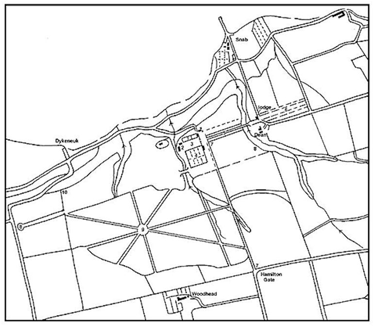
The resistivity survey was undertaken by Don Mathews and Ian Hawkins of the Edinburgh Archaeological Field Society with the help of several volunteers. Pupils from Kinneil Primary School helped to clear vegetation in the area between Kinneil House and the walled garden so that the survey could be extended into that area and thus include the accepted line of the ditch of the Antonine frontier. The survey covered the area between the House and the gate piers near the Museum, except for an area temporarily occupied by a stonemason’s yard used by HES during the reconstruction of the south wall of the Orchard. Unfortunately this masked some of the symmetry of the results and delayed a proper interpretation of the garden layout. The main drive is built up proud of the surrounding levels using blaes and, although on the original line, it also obscures the results.
The Roman ditch does appear as a faint band in the appropriate place (p) to the west of the walled garden, but its course along the north side of that garden is partially screened by trees and was not accessible. It would skirt the south edge of the survey area. The largest and most noticeable feature is an 8m wide strip of low resistance running W/E from the front door of the house towards the centre of the north boundary of the walled garden (a-a; plotted as L on illus 3). Its size and orientation initially suggested that it might be geological, but it is slightly smaller than the ditch (F10) found by excavation in Trench H. Close inspection shows a symmetrical layout to the north of the Avenue.
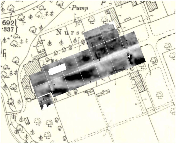
The dark area to the south of a-a (high resistance) is the bedrock which can be seen outcropping below the engaged column of the inner court and was noted during the installation of the nearby interpretative panel by HES (Kirkdale Archaeology 2011). On that occasion the rock was seen to dip down in the northern half of the trench and was directly overlain by cinders. This change corresponds with the edge of a-a, and the material suggests that it represents a broad path.
In the week before the excavation parch marks were observed in the grass over which the geophysical survey was undertaken. Just over 80m in front of the door to the house was a broad mark set perpendicular to and north of the main avenue, which also appears as a slight rise in the ground. This feature also appears as low resistance in the resistivity survey b-b and is mirrored by a less well defined feature to the south. It is around 4-5m wide. Its orientation indicates that it was associated with the house and the main avenue. To its east a series of narrow high resistance linear features indicate the presence of walls. First comes a narrow N/S band, similar in appearance to the south wall of the Orchard which also appears very distinctly. The second is broader and broken, fading out before it reached the orchard wall (c-c; plotted as K on illus 3). At the south end it returns along the north side of the drive. Further east still there is a host of linear features (d), some of which are parallel and some perpendicular to the drive. The wall connecting the south-east corner of the museum to the northern gate pier is clear on the survey (e) and also showed up well as a parch mark. Its east side is bordered by a band of low resistance, consistent with the ditch of a ha-ha.
Illus 16: Parch Mark from the Gate Pier to the Museum.
Another high resistance “wall” parallel with the survey grid runs 2m within the southern boundary of the area (f-f).
DISCUSSION
Roman
The character and location of the metalled surface (F12) indicate that this was part of the Military Way. It was preserved in Trench H because it was overlaid by later features, but beyond their protection it merely survived as a loose spread of gravel in Trenches I and J. It lies approximately 52m to the south of the Antonine Rampart up the north-facing hill. Westward it would have crossed the Gil Burn north of the so-called “Roman Bridge”. A prominent mound on this alignment can be seen between the stream and the walled garden. Beyond the valley it ties in with the medieval hollow way (Glendinning 2000).
The position of the ditch of the Antonine Wall can be seen as an 8m wide gap in the bedrock revealed by the work of Kinneil Primary School in 2017 at the foot of the wall that continues the west side of the walled garden northward. Its narrow width may have been due to the difficulty in cutting into the rock, or to the subsequent terracing of the area to be discussed below. What is clear is that the upcast mound to its north has been completely removed by that work.
No Roman pottery was encountered during any of the work in 2018 or 1990 and it is now possible to conclusively state that there was no Roman fort here.
Medieval
The early history of Kinneil is confused by legend. Traditionally it came into the possession of the Hamilton family as a gift from Robert the Bruce in the early 14th century when one of them killed a lieutenant of England on Kinneil Muir. By this time there was already a parish church and a sizeable village on the west side of the Gil Burn. Certainly it was in the possession of Walter Hamilton in 1323. We might therefore expect that the medieval seat of the family here would lie adjacent to the settlement and church, but as yet there is neither historical nor archaeological evidence for it.
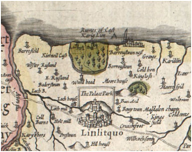
In 1473 Lord Hamilton was granted a royal licence ‘for the construction and building of a castle called Craglyoune sited above the sea’ (‘construendi et edificandi castrum infra mare situatum nuncupat Craglyoune’) and the next year received a royal charter confirming his ownership of the lands of the barony of Kinneil and of the ‘castrum de Kynneil nuncupatum Craglyoune’ (‘the castle of Kinneil called Craglyoune’). The name is an interesting one, latterly taking the form of Castle Lyon, and was discussed by Watson (1926, 383-4) and Macdonald (1921, 34). The former, bearing in mind the proximity of the Antonine Wall, noted the resemblance to Caerleon – the fort of the legions. The latter followed the author of the second statistical account in linking it to the dower-house of Lady Margaret Lyon, widow of the first Marquis of Hamilton, though she was fully a century after the place-name appeared. It occurs off the coast near the Snab as ‘Ruines of Cast. Karig Lion’ on the map drawn up by Hondius in 1614 and is repeated as such on Bleau’s 1640 map, both of which are largely derived from Pont’s notes and sketches made in the 1580s. However it is not depicted by Pont (36) and it would seem that the location given by Hondius is notional and connected to the reference made to the sea in the notes. It would have been completely incongruous to have built such an important residence on a small island in the late 15th century. Hondius has been followed by subsequent scholars and even the spurious presence of garden walls in this general area was used to confirm its previous existence (Mackenzie 1843, 130). The Ordnance Survey reported that the farmer of Upper Kinneil recalled having seen, around 1805, “portions of the Castle Garden Wall, remains of houses, and other indications of this castle” when trying to vindicate placing it on the site of the Kinneil Ironworks. It is surely significant that although the ruins of Inveravon Castle are noted in the original Statistical Account (Rennie 1799, 714), there is no mention of Castle Lyon.
It is normal for early historic seats in this part of Scotland to occupy land immediately adjacent to the Antonine Wall – the linear barrier forming an arterial road across the waist of Scotland. Local examples may be seen at Carriden, Inveravon, Callendar, Tamfourhill and Seabegs. A priori then this is where we should look for the medieval caput at Kinneil itself.
In its first recorded appearances the first part of the place name takes the form of crag or craig, being a rock (often associated with quarries). Rock outcrops all along the old coastline in the vicinity, from the Stey Step in the west to Carriden in the east, but it is only at Kinneil (and perhaps Carriden) that the Antonine Wall touches the coast and we can take Watson’s connection to it into account. Kinneil means ‘head of the Wall’.
The recent work has shown that at Kinneil the most prominent point at which the Antonine Wall and rock concur is at the north-west corner of the walled garden where there was a conspicuous hill. This raised area was emphasised by the quarrying away of its west side (Trench G) to create an escarpment upon which the west wall of the garden was subsequently founded. In this area we have the large ditch (F10), which appears to be earlier than the garden wall of 1552. There is no early medieval pottery, such as white gritty ware, from the vicinity. The oxidised and reduced green-glazed wares from the deliberate backfilling of the ditch cannot be closely dated, but belong to the 16-17th century. It is reasonable, on the evidence available, to assume that the ditch was infilled at the time that the walled garden was created.
It is therefore possible that the late 15th century house of the Hamiltons was located in the NW corner of what became the walled garden. As well as the ditch, which from its size is defensive in nature, there are traces of road surfaces (such as F19 in Trench C). The rubble rafts of the next phase (F22 & 42) were made up of demolition material which may have been derived from its buildings. The small angular lumps of sandstone had lime mortar attached and so were not waste from the work of the stonemasons in the 16th century. Unfortunately, the scraping down of the area to the bedrock in 1990 may have removed most of the foundations. These would have been anchored onto that rock on the higher ground.
The northern part of this postulated complex would have stood on the line of the Antonine Wall, with good views across the Forth Estuary. The buildings of Castle Lyon would have been completed by 1490 when another crown charter confirmed James, second Lord Hamilton, in his ownership of the lands and barony of Kinneil ‘together with the castle and fortalice of Craiglioun’ (unacum cum castro et fortalicio de Craiglioun’). Earl James died at ‘his place of Kinneil’ in 1529. In 1532 Margaret Douglas, wife of James, second Earl of Arran, received a life rent of ‘the tower and fortalice of Kinneil’ (‘turrim et fortalicium de Kinneil’). As Craig Lyon was within the barony of Kinneil, the change in name may or may not be significant, but the terms are often used interchangeably.
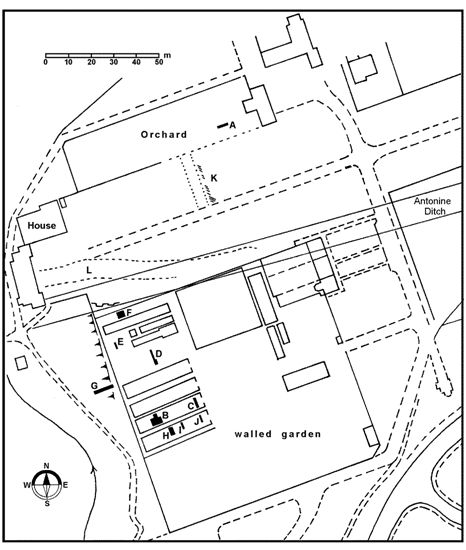
In the early 1550s work was under way on a new suite of buildings at Kinneil to replace the earlier ones. These are now known as the tower and the palace blocks. They form an L-shaped plan with the palace wing extending east from the north end of the tower. Tuskers on the south side of a later pavilion suggest that there had been an intention to construct a south wing to create a symmetrical U-shaped layout. This was never built. However, where its east gable would have stood there is a substantial wall, 0.5m thick, which extends from the remaining engaged column of the inner courtyard to the NW corner of the walled garden. This 3m tall wall has evidence high up of window apertures and at its south end the large quoin stones show a return to the east to form what is now the north wall of the garden for at least 13m (this length is higher than the remainder of the north wall). The implication is that this building (hereafter referred to as Building A) was earlier than either the 1550s house or the walled garden and so it would fit in with the timeframe outlined above for Castle Lyon.
Its location is significant. To the south the bedrock in Trench F is 2m higher than the land to the north and west. The building had been deeply terraced into the north-facing slope at the point where the ditch of the Antonine Wall lay. This meant cutting back the south slope of the Ditch to a vertical face and levelling the upcast and the north lip of the Ditch. Westward it also meant cutting away the bedrock to produce the scarp seen in Trench G. This would have provided stone for the building.
Following King James V’s untimely death in December 1542 James, 2nd Earl of Arran, became Regent of Scotland. This issued in a decade of building work at Kinneil commencing in 1545 when he had his chamber at Craig Lyon re-panelled with ‘Eastland Boards’ from the Baltic. Further references to building materials “at Kinneil” recur in 1549, but these are concerned at least in part with the movement of supplies for other projects, and specific references to other construction here (either at Craig Lyon or the current Kinneil House) cannot be confidently disentangled from the Duke’s other ongoing architectural work, such as the creation of Hamilton Palace and the completion of his lodgings in Edinburgh Castle. In 1549 he was granted the French dukedom of Châtellerault with its substantial revenues as a reward for consenting to Queen Mary’s marriage to the French dauphin and accepting a Scottish power-sharing agreement with the Queen Mother, Mary of Guise. In Scotland he is often referred to simply as the Duke. Trees for the Duke’s garden at Kinneil were supplied in 1552. In 1553 the Lord High Treasurer’s accounts record the provision of a horse for the ‘stane carte in Kynneil’ and payments of drink silver to Thomas Bargany ‘Masoun wirkand in Kynnele’ and to ‘the masons in Kynnele… at the laying of the ground stanes of the palice of Kynnele’. This is clear evidence of new build and as these dates accord well with the heraldry contained in the internal paintings of the palace block and the large armorial stone panel on the tower block we can be certain that it was their construction that were being recorded. The grounds were also laid out and walled gardens with fruit trees, thorn bushes, ornamental flowers, and kitchen plants including lettuce and marjoram are mentioned.
The walled garden created in 1552/3 would have combined such plants with more exotic species in a layout that included leisure pursuits and formal gardens. Building A attached to its north-west corner would still have been in use and the garden could be viewed from it. The lattice layout of paths within the garden enclosure would be appropriate for this phase. The main paths are shown on the plan of 1708 (see illus 19). They emanate from a circular feature placed north of the centre of the enclosure with one radial path focused on the building. These paths form a saltire with another path along the south axis from the centre. It is the northern edge of the SW spoke that occurs as the stone kerbing F39 in Trench H. The path almost at right angles to it must have been a lesser one not shown on the 1708 plan. By 1748 it would appear that the paths had been changed to more conventional cross grid pattern aligned with the walls (though caution must be expressed here as the scale of the plan of that date is such that the draughtsman may have been using a conventional notation). The grid had certainly been introduced before 1810 when another more detailed plan shows it (see illus 1). The fruit trees mentioned in the accounts may have lined some of these avenues and may be reflected in pits such as F31.
The north wall of the walled garden took its line from that of Building A. It may have been this fortuitous alignment that determined the line of the main drive and subsequently the grand avenue. We might have expected such an avenue to be aligned on some significant feature in the landscape such as an island in the Forth or an ancient abbey on a distant hill. Nearer to hand the Antonine Wall harped back to the Classical era and should have been a consideration, but is five degrees off line. The hill at Bo’ness obstructs views to the east beyond it, though the six-storey tower block acted as a large observation platform and from its vantage point it would have been possible to have seen some features over it. St Margaret’s stone near Pitreavie, Dunfermline, would be on the right line. Traditionally this huge Bronze Age standing stone which presents its cup-marked face towards Kinneil is where the future queen of Scotland rested in 1069 on her way to Dunfermline. Kinneil House stands just above the 30m contour and St Margaret’s stone on the 35m, but the hill at Bo’ness is just less than 60m tall.
Incorporated into the lower floors of the tower on the west side are two rows of large oval gun ports and these are often compared with the mid 16th century ones at Hamilton of Finnart’s residence at Craignethan Castle or the Outer Entry at Linlithgow Palace. Finnart was the Duke’s half brother and on his execution for treason in 1540 the property at Craignethan fell to the duke who is believed to have added the outer court with its large number of gunloops. That courtyard was protected by low crenellated walls entered by a modest gateway in the centre of the main front. These defences were largely for show and were overshadowed by high ground. At Kinneil it is strange that the gunloops are directed across a deep gorge carrying the Gil Burn and yet there is nothing to cover the more easily accessible eastern side. It is therefore highly probable that there was a forework similar to that at Craignethan set in front of the tower block which would have contained such gun loops and perhaps a small gatehouse. Some of the features observed in the resistivity survey may belong to just such a structure (b-b and c-c, illus 15; K on illus 3).
During a period of conflict between pro-English and pro-French factions in 1560 a French-led army burnt the mansion at Kinneil in retaliation for the Hamiltons’ alliance with their opponents. The sources suggest extensive damage, but the Duke and his family were in residence again by the following year. Trouble returned periodically and the palace of Kinneil was ‘burnt with fire’ on 29 May 1579 by an English army accompanied by their allies the Earls of Lennox and Morton (Morton himself claimed that the mansion was destroyed with gunpowder). As often occurs in such cases the degree of destruction was exaggerated and the main accommodation block was little affected, even the murals in the main chambers of the palace block survived. The damage was probably deliberately confined to the outer works in order to ensure that the property was no longer defensible.
Indeed, the House remained fit for a king. In the 1580s it was used as the main residence of James Stewart and the young King James VI became a regular visitor; until 1585 when James Stewart fell from grace. The king obtained some of the furnishings for Linlithgow Palace.
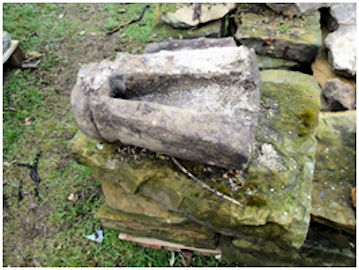
Illus 18: 16th Century Gargoyle Spout discovered in 2017.
The demolition of the postulated forework would have provided an opportunity to redesign the approach to the House and the recovered stone could be used in the new project. A tread stone from a small spiral staircase was used in the rebuild of the south wall of the walled garden, and a 16th century gargoyle spout was incorporated into the south wall of the orchard; this latter wall perhaps replacing part of the original outer forecourt.
The Duke of Hamilton was amongst the first to possess such a “chariot” and in 1611 a coachhouse was built at Kinneil (Marshall 2000, 108). The grounds were kept up to date by the addition of a bowling alley in 1604 (ibid, 115).
In 1667 work began on improving and enlarging Kinneil House as it was intended to be the residence of the Duke and Duchess’s eldest son. An account was put forward by Patrick Callendar, chamberlain of Kinneil, in 1671 for “the Dealles and trees” used “for the Castell of Kinneil.” Work must have been done on the inner courts and yards at this time, building upon those already present, creating a series of compartments ruled by the straight line – man’s dominance over nature. Cells occurred within cells with discrete functional uses. A separate walled garden was built on the north side of the avenue just for fruit trees. The 1673 rental mentions the large amount of lime used for the “new orchard dyke”.
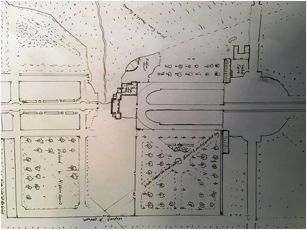
The 1670s work was a major refurbishment not just of the house but also of the grounds. Alexander Edward, perhaps the leading landscape designer of the time, was brought in to oversee the work. It was he who had the Avenue extended eastward with drystone dykes and hedges flanking the lines of trees. It now stretched beyond the courts and across a new bridge over the Dean Burn, built for that purpose. His design drawing of 1708 (RHP 89889) is still preserved, though until now it was thought to have been mostly aspirational. It shows the Avenue, which we have long known to have been executed, but also the previously unknown lattice pattern of paths in the walled garden. Also shown are the gate piers of the forecourt and the colonnade of the inner court. Both the parch marks and geophysical survey show that the gate piers were connected to the buildings to the north and south (then both stables) by a wall and ditch, presumably a ha-ha. This is marked on the 1708 map as a simple boundary, indicating a wall, with side entrances adjacent to the terminal buildings. These side entrances gave access to broad paths that followed the walls of the orchard and the walled garden to either side. As they approached the west end of the forecourt they broadened out and curved inwards towards the wide entrance in the colonnade to the inner court. This section of these paths was picked up on the resistivity survey (a-a). At its eastern end the southern branch of the paths is bordered on its north side by the wall f-f and a similar but much fainter line of high resistance can just be made out for its northern neighbour. These were presumably dwarf walls.
The terracing required for this new scheme was extensive and huge amounts of earth were moved. On the south side (uphill) the south wall of the orchard now retained more earth than it was originally designed for and conversely the removal of earth from its north side meant that it was not as well founded. Even so it was capable of doing the job, until in the late 20th century a line of trees was planted along its south side. It had to be rebuilt in 2017.
The lattice pattern paths in Trenches B and H were overlaid by clay and patches of comminuted shells (F37). The shell occurs adjacent to the cross path (F24). Such shells were easily obtainable from the beach at the foot of the Snab and the calcium carbonate in them would have neutralised the natural acidity of the clay. Their use indicates a growing understanding of horticulture and suggests a wholesale reorganisation of the garden in the mid 18th century.
BIBLIOGRAPHY
| Bailey, G.B. | 1996 | ‘Stream crossings on the Antonine Wall’, Proc Soc Antiq Scot, 126 (1996), 347-369. |
| Bailey, G.B. | 2015 | Kinneil Park. |
| Glendinning, B. | 2000 | ‘Investigations of the Antonine Wall and medieval settlement at Kinneil House, Bo’ness, Falkirk’, Proc Soc Antiq Scot, 130 (2000), 509-524. |
| Historic Environment Scotland | 2017 | Kinneil House: Statement of Significance |
| Kirkdale Archaeology | 2011 | Kinneil House: New signage watching brief, July 2011. |
| N.S.A. | (1834-1845) | The new statistical account of Scotland by the ministers of the respective parishes under the superintendence of a committee of the society for the benefit of the sons and daughters of the clergy, 15v. Edinburgh. Page(s): Vol. 2, Linlithgow, 129-30. |
| Macdonald, A. | 1941 | The Place-Names of West Lothian. |
| MacIvor, I. | 1978 | Craignethan Castle: Official Guide. |
| Ordnance Survey Name Book | Book No. 14, 37. | |
| Stone, J.C. | 1983 | ‘Timothy Pont and the first topographic survey of Scotland c.1583-1596: an informative contemporary manuscript’, Scottish Geographical Magazine, 99 (1983), 161-168. |
| Watson, W.J. | 1926 | The History of the Celtic Place-Names of Scotland. |
G.B. Bailey (2019)
APPENDIX
Context Nos.
2. Topsoil, Trench A.
3. 0.5m thick layer of dark brown loam with mortar specks, tile & broken sandstone, Trench A.
4. 0.25m thick layer of brown clay loam with tobacco pipes, Trench A
5. Very compact black clayey soil over natural, Trench E.
10. Large ditch in Trenches B & H.
12. Small rounded pebbles with well rolled surface. Metalling, Trench H – Roman road.
18. 0.1m deep shelf at the south end of Trench C.
19. Gravel road metalling at north end of Trench C, set in slight depression.
20. Brown clay loam over F21, Trench B.
21. Thin purple clay spread over F22.
22. Stone raft to east of kerb F35 made of small angular pieces of sandstone with mortar.
23. Orange-brown clay loam below F22.
24. Disintegrated red-brown sandstone occurring in patches in Trenches B & D above the natural.
25. Medium-sized angular cobbles set on top of each other in the NR corner of Trench C, resting on road surface F19 and surrounded by F44.
30. Top fill of ditch F10 with flat stones laid over part of it.
31. Large circular(ish) pit loosely filled with small pebbles and burnt sandstone. Trench B.
32. Middle fill of ditch F10 below F31, Trench B.
33. Sandstone flags laid on F30 at base of F35.
34. 0.7m of brown clay loam with frequent flecks of charcoal and specks of lime mortar.
35. NW/SE alignment of medium-sized cobbles, Trench B – kerb of 16th century path.
36. Compact dark brown soil (former topsoil), Trench H.
37. Lenses of comminuted shell.
38. Buff clay loam forming top fill of ditch F10 in Trench H.
39. W/E line of small boulders in line with F40 at south end Trench H.
40. Large boulder in east baulk of Trench H – corner stone of paths.
42. Secondary ditch cut into Trench H filled with rubble.
43. Stone raft in Trench H.
44. Thick layer of buff clay loam over F18 & 19, Trench C – cultivation soil.
47. Brown-orange clay loam fill in ditch F10 below F43, Trench H.
50. Horseshoe drain with sulphurous slag in trench, Trench H.
