Over the summer of 1759 a handful of industrial entrepreneurs from England scoured central Scotland for a suitable site to establish a massive ironworks. Dr John Roebuck and Samuel Garbett were familiar with various working plants in England and were aware of the importance of canals and waggonways for transporting large quantities of raw materials as well as of water power for driving mechanical operations such as polishing and boring. In June that year Garbett wrote to his Scottish partner, William Cadell senior:
“1 Furnace, 3 Forges, and a slitting Mill, would be a compleat Set of Works, and the Water of Carron is not only sufficient to supply such a Sett but is capable of supplying double that quantity, and it appeared to me that at a small expence we might be able to carry all our Iron & c from one Mill to another with Boats which is a very material consideration…
We would at the same time endeavour to secure every Mill upon the Water but let them continue grinding of Corn until We wanted them for our own purposes…”
(Cadell 1912, 152).
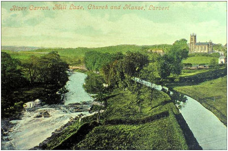
On 19 December 1759 Larbert Mill was leased from the Earl of Errol by the embryonic Carron Company (Watters 2010, 13). The lease included specific mention of the water from the damhead as it was intended to lead water over a distance of 3km along a contoured lade to drive the bellows for the blast furnaces at Carron. In 1760 work began on extending the lade of Larbert Mill to the ironworks. 20 soldiers were sent from Bo’ness to augment the 40 or so men digging its channel. The Lade was to be 4½ft-5½ft deep with a breadth at the top of 14ft, narrowing to 10ft at the base (Watters 2010, 23). An aqueduct was built to carry it over the Broomage Burn. Larbert Mill itself was to be taken down soon after Whitsunday that year. In this form the Lade was completed by the end of October. It entered the ironworks on the high ground west of the blast furnaces, where it stopped. The water was then carried in a wooden trough to the water wheels, which powered the huge wood and leather bellows.
At the beginning of 1760 the Carron Company also acquired the paper mill at Guildfield and the adjoining waulk mill that lay 0.5km upstream. The former was converted into a grinding mill and many of its large grinding stones can still be seen littering the area. Sad irons were amongst the first products of the foundry and even as late as 1868 Gillespie noted that this mill was used “for the polishing of smoothing irons, and other metal articles requiring high finish” (1868, 91).
The difficulty of getting heavy and brittle iron castings from the ironworks to these mills along the poor roads of the time would have been considerable. One simple solution was to use the Lade. The use of the Lade as a canal would fulfil Garbett’s ambition to “carry all our Iron & c from one Mill to another” by water. Perhaps this dual use is what is implied in the wording of the feu for the works agreed between Dr Roebuck and Sir Michael Bruce on 13th December 1759: “for making a Canal and water-course and lead through and over any part of his lands of Stenhouse both to and from the said Forges and Furnaces with full power, liberty and priviledge of Navigating Sloops Boats and Lighters up and down the River Carron as well as in the Canal or Water course before mentioned.” (Campbell, p.32).
When Nimmo wrote his ‘History of Stirlingshire,’ which was published in 1777, the Carron Canal to the east of the ironworks had not been formed and the much shorter mill race for the boring mills was used for this function. It, together with the Lade from Larbert, would explain Nimmo’s statement that “The appendages of this work, such as dams, canals, and reservoirs, extend several miles alongst the banks of the river” (Nimmo 1777, 462). It may even go some way to explaining the mistake made in a description of the industrial complex by Jacob Pattison in 1789. He evidently mistook the Lade for the Forth and Clyde Canal: “A vast basin of water for all these purposes has been formed near these works, & is regulated by sluices from a neighbouring canal, which itself has not been long cut & joins the Forth with the Clyde.”
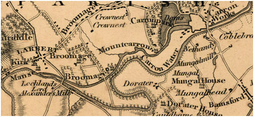
The Lade cut across a series of riggs in the lands of Broomage and the Carron Company provided temporary wooden bridges for the owners so that they could access the truncated southern ends. There were, however, only three fixed bridges. One of these carried the main road from Larbert Cross to Larbert Bridge at the Low Town; one took Carronvale Road; and the other was for a lesser road from Larbert to a ford downstream (near Munnoch’s Nursery). The latter was used by drovers to take cattle to the Trysts near Bonnybridge. It is referred to in this letter from the Road Trustees:
“…continuing the foord road at Larbert and of having a Bridge thrown over the Carron Company’s canal cutting that road… delay to the tenth of October next when Mr Garbet promises that the Bridge shall be in such forwardness as will make it convenient and easy for black cattle to pass that way and that the meeting requires that that bridge shall be twenty feet wide within parapet walls and the said walls three feet high above the surface of the road on the bridge…” July 1761.
[a1.452]
It is difficult to know whether the term “canal” in this letter is used as a generic term for an aqueduct or if the Lade was being used as a true canal for the passage of small lighters. At that period the only other waterway that was also often termed a “canal” was the mill race from the boring mill at Carron Iron Works that from 1771 ran to the River Carron near Carronshore. This length of artificial water was certainly used for small lighters of 4 tons burden and was dependent upon the tide. These vessels, smaller than later canal barges, were tracked from the banks by teams of between six and a dozen men and carried finished products to the harbour at Carronshore, where the goods were transhipped to sea-going vessels.
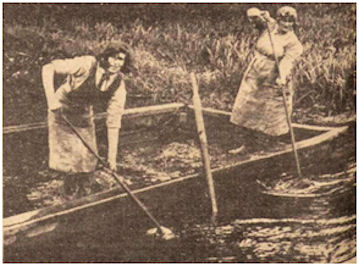
Illus 4: The annual clean-out of the Lade (Falkirk Herald 10 June 1931, 16).
The use of the Lade westward from the ironworks would have allowed heavy products to be taken from the Forge Pool to the mills up river for finishing and then returned for onward passage to Carronshore. The rate of flow of the water in the Lade was minimal, far less than that in the river, and it would not have been a serious impediment to its use. The current would have only been a small aid to the return journey. So slow was the flow that a lade keeper was employed to keep it free of weeds and swans were kept for the same reason.
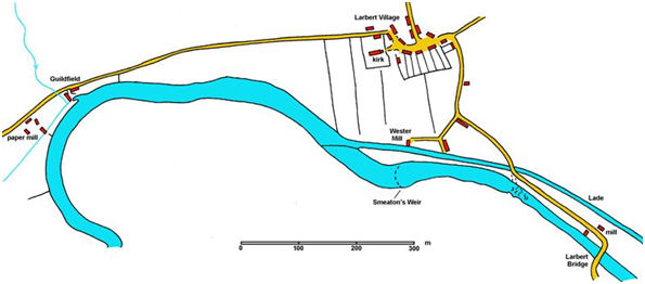
Once out into the river beyond Larbert Wester Mill the weir would have ponded a fair depth of still water up to the grinding mill and a contemporary map shows a small inlet at Guildfield Mill in which the barges could have unloaded.
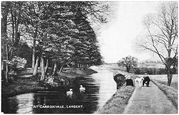
Illus 5: The Lade at Carronvale c1910.
As with the race from the boring mill and the river to Carronshore, manpower rather than horsepower would have been used to track the small barges. This kept any erosion of the banks to an absolute minimum. Today the Lade has a footpath along its south side which is probably the direct descendent of the tracking path.
Beyond the ancient weir which served the Wester Mill the north bank of the river was built up behind a retaining wall as far as Guildfield Mill so that it could be used as a towing path.
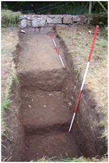
Illus 6: Trench B – section showing dumped soil of the terracing for the towing path near the weir with the retaining wall at the back.
.
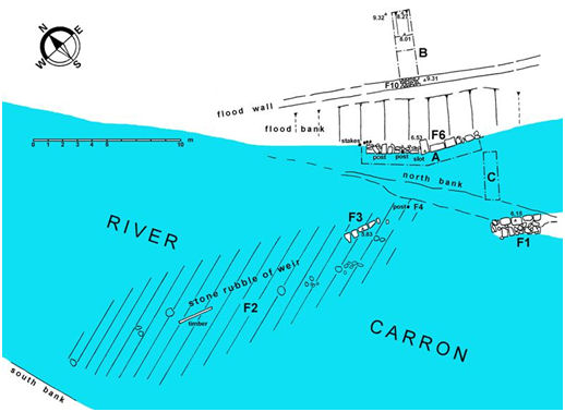
At the western end of the Lade the haulers would have needed to cross it in order to continue the last leg along the north bank of the river and here in 2010 the point where the lade originally joined the river was examined by the author and a team of volunteers. At the end of the walling (F1) separating the Lade from the river a large post (F4) was found at its junction with the weir. It was matched by two posts on the north bank and they appear to represent the remains of a footbridge over the Lade. At this point the north bank had been built up with a wall of good quality stone of large, finely-dressed oblong blocks. Whilst the rubble of the weir was clearly earlier, the tooling and style of the well-coursed abutment show that it was of mid-18th century date.
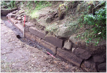
Illus 8: Abutment Wall in Trench A looking north-west.
.
In 1771 the manager of the Carron Company, Charles Gascoigne, informed his partners that
“the Damhead at Larbert is in so ruinous a state as to render the repairing of it impracticable… I have attended with Mr Smeaton in order to fix upon a situation for a new damhead there… estimate of expense from John Easton.”
John Smeaton, perhaps the leading water engineer of his time, designed the convex damhead on the River Carron 240m below the old weir and work began on it in 1772.Once completed, it replaced the old structure which was allowed to fall into decay. The 1770s entrance to the Lade next to Smeaton’s weir was replaced with a large sluicing mechanism in the 19th century and so we do not know its original form. Presumably the lighters were still able emerge onto the river to reach Guildfield Mill. It would appear that they re-entered the isolated section of the old lade in order to get around the abandoned weir, explaining why the stonework at the old junction (F1) is now isolated.
The ironworks was short of water for its wheels and in 1776 Smeaton recommended raising the banks of the aqueduct/lade in order to increase the supply. This was duly executed and one consequence was that larger boats could be used. It may have been this work that was responsible for an incident two years later. On the night of 12 April 1778 the aqueduct bridge over the Broomage Burn gave way and the Carron Dams emptied. The bridge and banks at Broomage were entirely swept away. With the permission of Sir Michael Bruce and Alexander Brown a “temporary conductor for the water round the valley” was made. The ground of the valley “up to the surface level of the water in the Lade” was then bought from the two landowners. A small pool, known as Lamond’s Loch, was formed and the water from the Broomage Burn was diverted into the Lade, augmenting the water supply.
The increased height of the water in the Lade corresponded with an increase in that of the river behind Smeaton’s weir. The river west of the weir now acted as a large reservoir. This too would have aided the cargo carriers by stilling the water.
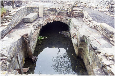
Illus 9: A Lock Chamber on the Carron Works Internal Canal excavated in 1994
.
After the initial construction of the Lade, the next stage in its development as a canal would have been a connection with the canals within Carron Works – but that is perhaps best dealt with in a separate article about the “Carron Works internal canals.”
The small size of the lighters that could be used on the Lade would have meant that the improvement in the roads in the following century and in the design of lorries would have reduced the benefits of water transport. In any case, more and more of the finishing work was done at the main Works as the management of the water was enhanced and steam power introduced. The use of the lade as a transport artery fell from memory.
SMR 1623 Carron Lade NS 8558 8202 to NS 8755 8222
Bibliography
| Bailey, G.B. | 2010 | ‘Excavations on the River Carron at Larbert.’ Unpublished. |
| Cadell, H.M. | 1912 | The Story of the Forth |
| Gillespie, R. | 1868 | Round About Falkirk |
| Metcalfe, M.H. | 1948 | Notes on the History of Carron Company. Unpublished. |
| Nimmo, W. | 1770 | The History of Stirlingshire. |
| Pattison, J. | 1789 | Journal of Tour of the Highlands, Jacob Pattisson, Physician. |
| Reid, J. | 2004 | ‘East Stirlingshire Mills: Part 1’, Calatria 21, 61-89. |
| RHP | Register House Plan | |
| Watters, B. | 2010 | Carron: Where Iron Runs like Water. |
| GD58 | Carron Company Papers in the National Archives of Scotland. |
