Travelling along the back road from the Hills of Dunipace to the village of Dunipace near Denny, the stately mansion of Denovan is seen proudly overlooking the road opposite to the old Denovan Parish Church. However, it is not the original house of Denovan – that lies a little further west and is now known as Denovan Mains.
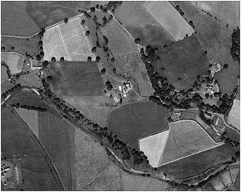
This farmhouse has largely been neglected by archaeologists and architectural historians which is unfortunate as it is of great interest. The site has considerable merit, overlooking one of the early crossing points of the River Carron. The house stands on the shoulder of a small hill, a terrace dominating the river. An aerial photograph of c1950 shows a dark curving band representing a large infilled ditch following the contour of the hill, hinting at the presence of an early native fort.
The date of this ditched enclosure cannot be ascertained. It may have been associated with the early feudal residence, but the discovery of both Bronze Age and early Christian cists in the immediate area indicate a broad period of occupation. The area was quarried for sand and gravel in the late 1960s and the ancient site is not therefore available for archaeological investigation.
The early estate of Denovan, lying between the Avon or Anchor Burn and the lands of Dunipace, is more properly known as “Little Denovan” to distinguish it from “Meikle Denovan” which lies west of that burn. However, as the latter term is no longer in usage, we can stay with the name of Denovan. For the greater part of its known history it was owned by cadets of the Forresters of Garden who also held Torwood. No fewer than eight Forresters of Torwood were Provosts of Stirling burgh. The owners of Denovan can be summarised as:
| c1590 | John Forrester of Garden |
| 1609 | David Forrester (son) |
| 1686 | David Forrester (grandson) |
| 1733 | Thomas Forrester (son) |
| 1772 | David Forrester (son) |
| 1773 | John Johnstone of Alva (purchase) |
| 1795 | James R Johnstone (son) |
| 1839 | William Forbes (purchase) |
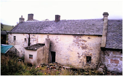
Illus 2: The earliest part of Denovan Mains (Block A) in 2012 looking north-east.
The Forresters of Denovan were merchants and burgesses of Stirling with their own burial aisle in the West Kirk there. The fabric of the present building suggests that the earliest part was the northern end of the west wing – it is a low two-storey block made of random rubble with relatively small windows having backset margins. A date in the late 16th century would be consistent with this style. Before long it was extended to the south. First-floor windows with backset margins in the two gables show this was a good quality house.
Illus 3: Denovan Mains, 2012, looking NNW with the mid 17th century block in the centre.
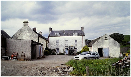
In the middle of the 17th century, the house was greatly enlarged and re-orientated. A new block aligned W/E was added to its north end. This was a tall two-storey block made of coursed rubble with a dormer storey above. The main façade faces south-south-east and its plain harled and white-washed mass is impressive. It is punctuated by two windows and a central doorway on the ground floor and three windows on the first arranged in the conventional symmetrical pattern.
A single storey east service wing was added to create a small courtyard in front of the house with a dwarf wall closing it off on the south side. The south gable of the east wing contains a pigeon loft creating a focal point.
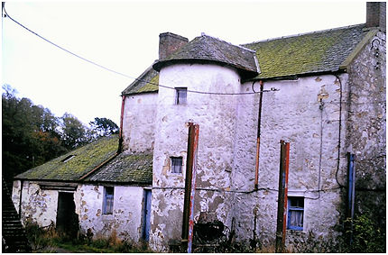
Illus 4: The Rear Façade of Denovan Mains with Stair Tower, looking south-east.
A slender circular stair tower occupies a central position on the back façade – its semi-detached nature imposing a baronial appearance. However, the skews are plain.
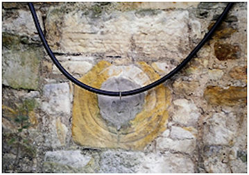
Illus 5: The round window light in the north gable of the west wing; now blocked.
The new block overlapped the original dwelling producing a re-entrant angle at their south-westerly junction. Here a round light with two concentric grooves was inserted into the old gable for decoration.
This house must have been commissioned by David Forrester who held the lands for almost eighty years. His son, Thomas was a dissenting minister who attended conventicles. After a period of exile abroad he returned and became principal of the new St Mary’s College in St Andrews. As a consequence the succession of the estate skipped a generation and David left it to his grandson in 1686.
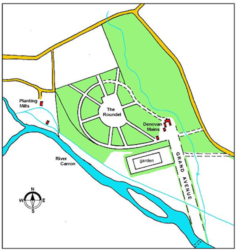
It was probably also David Forrester senior who extensively laid out the grounds. The hill fort was used as the focus of new woodland with avenues radiating out from the top of the hill – reminiscent of the use of the broch at Torwood. This was known as The Roundel. In the centre was an open space. A modest walled garden was placed on the terrace below and a grand avenue of trees ran from the front of the house to the ford on the river. This layout is clearly depicted on Roy’s map of c1755, but it was removed within a century of the map being drawn up and nothing now remains. Indeed, some have questioned its former existence, but its presence is confirmed by a map of the river and its mills surveyed for the fledgling Carron Company in 1760 (RHP 1497).
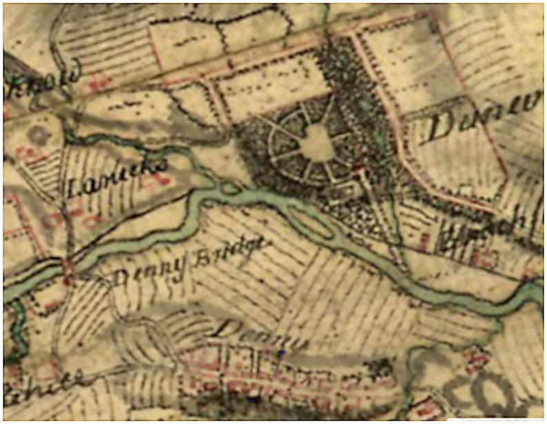
There are some inconsistencies between the two maps and the following plan is an attempt to resolve them and to provide a clear layout of the designed landscape in the mid 18th century.
Wood was a valuable crop and the Forrester family still had interests in Torwood. Income was derived from that woodland.
“THE TORWOOD, lying below the High road leading from Falkirk to Stirling, belonging to Thomas Forrester of Denovan, is to be sold betwixt and Martinmas next. Any persons inclining to purchase, may give in their proposals to the proprietor at Denovan, any time betwixt and the first of October.
The wood consists chiefly of oak timber, with some birch and alder.”
(Caledonian Mercury 27 June 1764, 3).
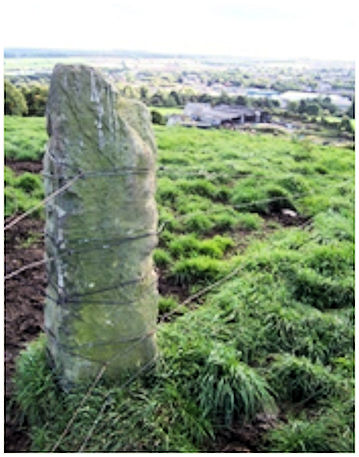
Illus 9: Toptowie Standing Stone looking south with Denovan Mains in the background.
Beyond the immediate surroundings of Denovan Mains there are two standing stones on hills to the north – on the summits of Toptowie and Drumhead (Doghillock). These are reminiscent of the late 18th century landscape features at Glen Ellrig and Castlecary. Closer to home there were standing stones at Herbertshire Castle (the Hornbeam) and Ingleston.
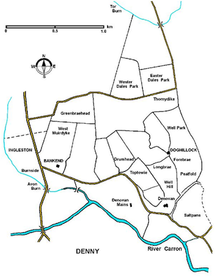
The extent of the lands of Denovan varied with time. It is given in 1635 as:
“the orchard and Mains of Little Denovan, lands of Scrabtreebank called Doghillock and Burnside, the town and lands of Ingliston, Wester Burnside and Muirdykes, lands of Mossside and Thorns.”
(Reid 1996, 50).
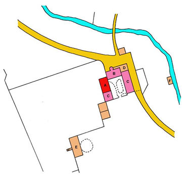
Further extensions and buildings were added to Denovan Mains in the 18th century. The first of these was a single-storey building on the same alignment as the west wing, but deliberately stepped back from its south end. In its south gable there is a large arched entrance for a cart or coach – more probably the latter –with a hay loft above. There were now three gables facing in this direction. These were, from east to west:
- The single storey gable of the east wing with a pigeon loft.
- The low two storey gable of the early house.
- The single storey gable with coach archway and loft door.
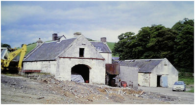
Illus 10: The Coach House at Denovan Mains looking north-east.
The extension to the house merely consisted of a single storey lean-to structure to the east of the stair tower on the north side of the main block, imparting a piended roof to the north end of the east wing. A small building beside the stream (F on the plan) was probably a washhouse.
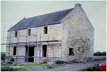
Illus 11: Dwelling “E” during refurbishment in 2003, looking south.
To the south-west a two-storey block (E on the plan) was deliberately sited to extend the stepped gables of the buildings facing the Grand Avenue. Its south gable was of droved ashlar surmounted with a ball finial (the north gable by a chimney). It was perched on the edge of the escarpment and presented its main façade to the drive. Shrouded in the middle of 20th century agricultural lean-to shelters it was difficult to appreciate this building until they were removed in 2003 and the east façade was cleaned. The photograph clearly shows that the façade is made of coursed sandstone (almost ashlar) whereas the other walls are of random rubble.
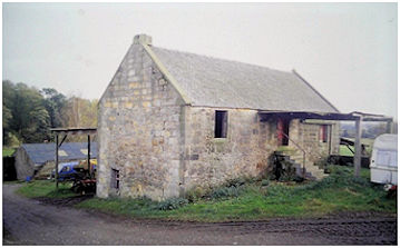
Illus 12: Dwelling “E” prior to refurbishment in 2001, looking south-east.
The symmetrical disposition of the windows and the smaller size of the upper ones were designed to impress. (The central doorway was enlarged at a later date for agricultural purposes and the 1860 Ordnance Survey map shows an unroofed gin mill here). One tradition states that this building was a coachhouse (hence its present name) – which it clearly was not. The ample window accommodation and fireplaces show that this was a dwelling.
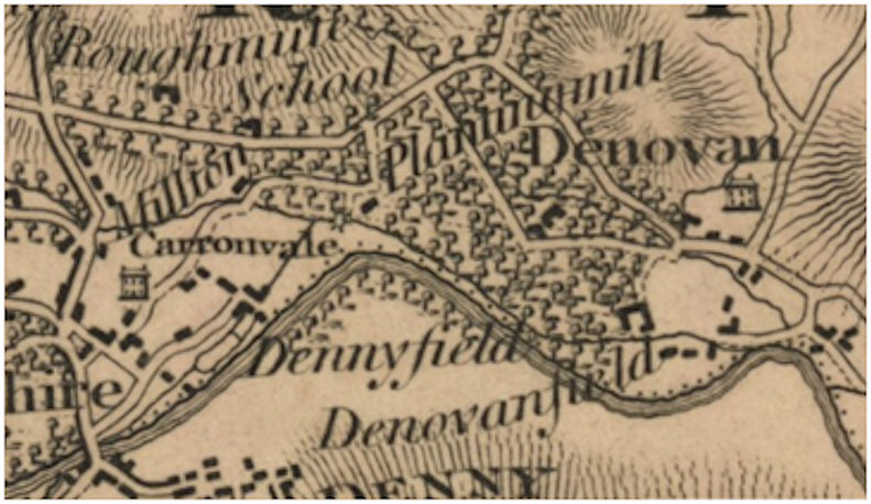
Around 1751 Alexander Colvin feued land on the river meadow to the east of the grand avenue for use as a bleachfield. The Denovan Bleachfield became one of the largest in Scotland and an elaborate water supply system was built up. Spent water from the lint and corn mills to the west was fed into a lade running parallel to the river. The corn mill was known as “Planting Mill” after the extensive plantation. The stream that flowed in the small valley to the east of Denovan Mains was diverted into the bleachfield. Alexander Colvin also grew flax at Orchard of Denovan.
Denovan remained in the Forrester family until 1773 when David Forrester sold it a year after inheriting.
“To be SOLD, by public voluntary roup, within the Exchange coffeehouse, Edinburgh, upon Wednesday the 2d of December, 1771, at five o’clock afternoon, All and whole the Lands and Estate of DENOVAN with the tiends and pertinent thereof, and superiorities thereto belonging, lying with the parish of Dunipace, and sheriffdom of Stirling.
The property lands consist of 1130 English acres, all lying contiguous, and most beautifully situated on the north side of the river Carron, within four miles of Falkirk, and five miles of Stirling, and within two miles of one of the most considerable stations on the great canal between Forth and Clyde. The rental, after every deduction, (the cess being paid by the tenants) extends to about 496 l. sterling. The greatest part of the lands are out of lease, and a purchaser may have immediate access to a large farm. There are several lime quarries in the grounds, some of which are not rentaled. There are going coal-works in the neighbourhood, and there are coal and iron-stone on the lands, though neither are wrought at present. On this estate, there is a large quantity of thriving barren planting, to a considerable value, laid out with a view to a mansion-house, and well advanced; and a more delightful situation for a house or lands, better adapted for policy and improvement, are seldom to be met with.
The whole lands hold of the crown, and are valued in the cess-book at above 905 l. – Robert Stewart, at the house of Denovan, will show the lands; and a rental, survey, and progress of writs, may be seen in the hands of David Erskine, Clerk to the Signet.”
(Caledonian Mercury 15 July 1772, 4)
The new owner was John Johnstone of Alva and for the first few years he styled himself as “of Denovan.” Thereafter Alva House seem to have been his principal residence. In 1774 he was elected as MP for the boroughs of Kirkcaldy, Dysart, Kinghorn and Burntisland. He still used Denovan for shooting and in 1793 he and his son, James Raymond Johnstone, acquired game licences. James was styled “Esq of Denovan” suggesting that he was living there. Covering 1,130 English acres, the lands of the estate gave plenty of scope for hunting. George Easton was the overseer at Denovan. The farms brought in a good income and included
- Kirkland Mill Park (18 Scots acres)
- The mill and mill lands of Linkumbank (immediately above the last)
- Doghillock, Drumhead, Toptowie, Easter Muirdyke, Easter and Wester Dalls and Gunnershaw Greens (230 Scots acres plus moss)
- Ingliston, Burnside, Greens Braehead, Wester Muirdyke and North Bankend, Blackhill and Edge Face (230 Scots acres)
- Upper and Lower Dykehead (60 acres).
Over the next four decades much of the valuable timber was sold off – oak, elm, ash, plane and others. The land was then improved and enclosed, together with some of the moss, with contractors employed to build extensive field dykes. Grassom’s map of 1817 shows the area of the plantation still wooded, but it does not show Denovan Mains as a “country seat.”
In 1800 James Johnstone leased the field of “Dunner” to a company for the establishment of a printfield. This concern gradually grew in size, eventually taking over the adjacent bleachfield and employing around 600 workers at its peak. As many of them resided in Denny a wooden footbridge was erected at the site of the ford. The freestone quarry at Thorneydyke on the Denovan estate was also opened up and fully exploited at this time, as were the lime quarries.
1839 was a momentous year. A small earth tremor occurred in the area, waking the citizens of Denny in their beds. Eight miles above Denny a large reservoir was broken down and the area around inundated with water. Several dam heads were driven down and there was extensive flooding. The surge also carried away a large portion of the wooden bridge at Denovan. That same year Denovan estate was bought by William Forbes of Callendar. As part of a much larger holding it was inevitable that Denovan Mains should be let as a working farm.
The tenant was James Burrell (or Birrell) who ran a dairy herd and bred Ayrshire cows which won prizes at stock shows. The pasture around the house was of good quality. Even the small island in the Carron, known as the Inch, was utilised for grazing. In November 1877 the river flooded once again and the island was submerged, requiring the cattle to be ferried to the dry land on the higher ground. Flooding was a perennial problem and before the construction of the Carron Dam the haughs were frequently covered in water each winter.
James Burrell’s brother had the tenancy of Ingleston Farm to the west. Upon James’ death his son, also James Burrell, took over Denovan Mains. In 1877 an action for seduction and breach of promise was brought against him by Mary Hay. Mary had entered service at Denovan Mains at Whitsunday 1871 at the age of 19 as the housekeeper to manage his dairy with the assistance of a girl. A relationship soon developed between the two and he promised to marry her. In 1876 she had his child, but still the promise of marriage was not acted upon. She then found that he had also had a child with Jean Boyd, a farm servant at Ingleston. Mary left and returned to her family at Glenhead and the court awarded her £70 and a yearly aliment of £7 to care for the child.
The remnants of the plantation were still evident. The larger tree stumps were difficult to remove and required time-consuming operations to dig them out, meaning that it was an expensive undertaking. Technology came to the aid of the farmer and the innovative spirit of the age is captured in this extract from the Falkirk Herald of 13 July 1878:
“DYNAMITE EXPERIMENTS – The shattering of the stubs of trees by dynamite – the first experiment of the kind in this district – was witnessed on Thursday night last on Denovan Mains, in the parish of Dunipace. Mr John Brooks, of Lancashire, one of the representatives of Nobel’s Explosive Company, conducted the operations, and was accompanied by Mr John Brown, of Messrs John Brown & Co., the agents for the district. The stumps selected to be exploded were in a field west from the farm of Mr James Birrell, and in each case the powerful effect of dynamite was satisfactorily and amply demonstrated. The first experimented on was an elm stump fully three feet in diameter, into which was inserted 12 oz of dynamite. The stump was blown into shivers, and almost completely lifted from its bed. The dynamite proved equally successful in shattering beech. The company present expressed themselves as gratified with the result of the evening’s work, and in laudation of the great practical value of dynamite. To show that dynamite would not explode though attacked by a hammer, Mr Brock placed a quantity of it on a stone and struck it with a hammer, the result being that the portion struck only exploded – the surrounding quantity remaining in its normal state. The advantage which farmers will gain in clearing ground of stumps by dynamite instead of the expensive mode of digging them out is sufficiently apparent without being pointed out by us.”
The following week the newspaper had to correct the report – the hammering had not produced any sort of explosion as only a detonator could do that! The “experiments” were clearly a form of advertisement and further demonstrations were arranged on the farm.
| Forenames | Surname | Relation | Age | Occupation | Where Born |
|---|---|---|---|---|---|
| James | BURRELL | Head | 41 | Farmer of 160 acres of which 85 arable | Dunipace |
| Mary | MENZIES | Servant | 23 | Dairymaid | Denny |
| Elizabeth | HENDERSON | Servant | 22 | General Servant | Falkirk |
| Mary | LEISHMAN | Servant | 14 | General Servant | Falkirk |
| Margaret | MENZIES | Boarder | 3 | Dunipace | |
| Isabella | MENZIES | Boarder | 2 | Dunipace | |
| Agnes | MENZIES | Boarder | 1 | Dunipace |
Despite his misspent youth, James Burrell became a pillar of the local society. He had a flair for land surveying and was often called upon by farmers in the area to measure their fields so that their contents could be sold. He performed this task on numerous occasions, without charge, and in 1881 he was presented with 60 guineas, a theodolite and a measuring chain as a sign of appreciation. He was a committee member of the Denny & Dunipace Agricultural Association which was formed in 1880. In June 1883 the fourth annual show was staged on his fields to the west of Denovan Mains and returned the following year, and in 1890. James Burrell junior died 4 May 1891, aged 50. A new tenant was needed:
“DENOVAN ESTATE. To Let, with Entry at Martinmas, 1893, for such number of Years as may be agreed upon, THE DESIRABLE FARM of DENOVAN MAINS, in the Parish of Dunipace, extending, as per Ordnance Survey, to 97 Acres or thereby of Excellent Arable and Grazing land. The Farm is situated close to the Burgh of Denny and Dunipace, where there is a Good Market for all Farm Produce.” Callendar Estates. .
(Falkirk Herald 8 July 1893, 1)
That October, there was a deplensihing sale at Denovan Mains and Ingleston. The new tenant at Denovan Mains was Robert Graham, who continued to keep a dairy herd there and to show prize specimens. Robert Graham died in 1928 and the farm was run by David Graham until 1946 when his son Robert took over. It then passed to J Graham and the company of J Graham & Son was formed and still operates from the farm. During its years as a dairy farm the east wing of the complex has been largely rebuilt and now appears as a 19th century typical dairy with modern divisions.
The Roundel has had an amazing depth of history. It was a Bronze Age burial ground, probably an Iron age fort, an early Christian and an early feudal settlement. In the 17th century, an imposing plantation was created when avenues and vistas were in vogue. It then reverted to pasture – with the help of early experiments with dynamite. However, in the late 1960s even the hill was removed during gravel extraction.
In 2013 the “coach house” was converted into a separate dwelling and land nearby was used for the construction of two more. The farm is still a working farm and is private.
Sites and Monuments Records
| Denovan Mains | SMR 412 | NS 8171 8339 |
| Toptowie Hill Standing Stone | SMR 765 | NS 8177 8369 |
| Doghillock Standing Stone | SMR 766 | NS 8157 8393 |
| Denovan Long Cists | SMR 118 | NS 815 835 |
| Denovan Cists | SMR 111 | NS 815 835 |
| Denovan Print Works | SMR 1176 | NS 8187 8312; NS 8204 8310 |
Bibliography
| Gibson, J.C. | 1908 | Lands and Lairds of Larbert and Dunipace Parishes. |
| Hunter, D.M. | 1971 | ‘Two groups of cists at Denovan near Dunipace, Stirlingshire,’ Glasgow Archaeological Journal 2, 31-38. |
| Reid, J. | 1996 | ‘The Feudal Divisions of Denny and Dunipace: Part 2,’ Calatria 9. 35-54. |
| RHP | Register House Plan |
G.B. Bailey (2020)
