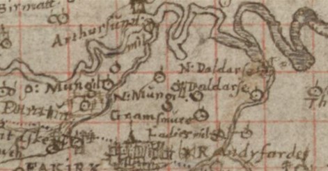
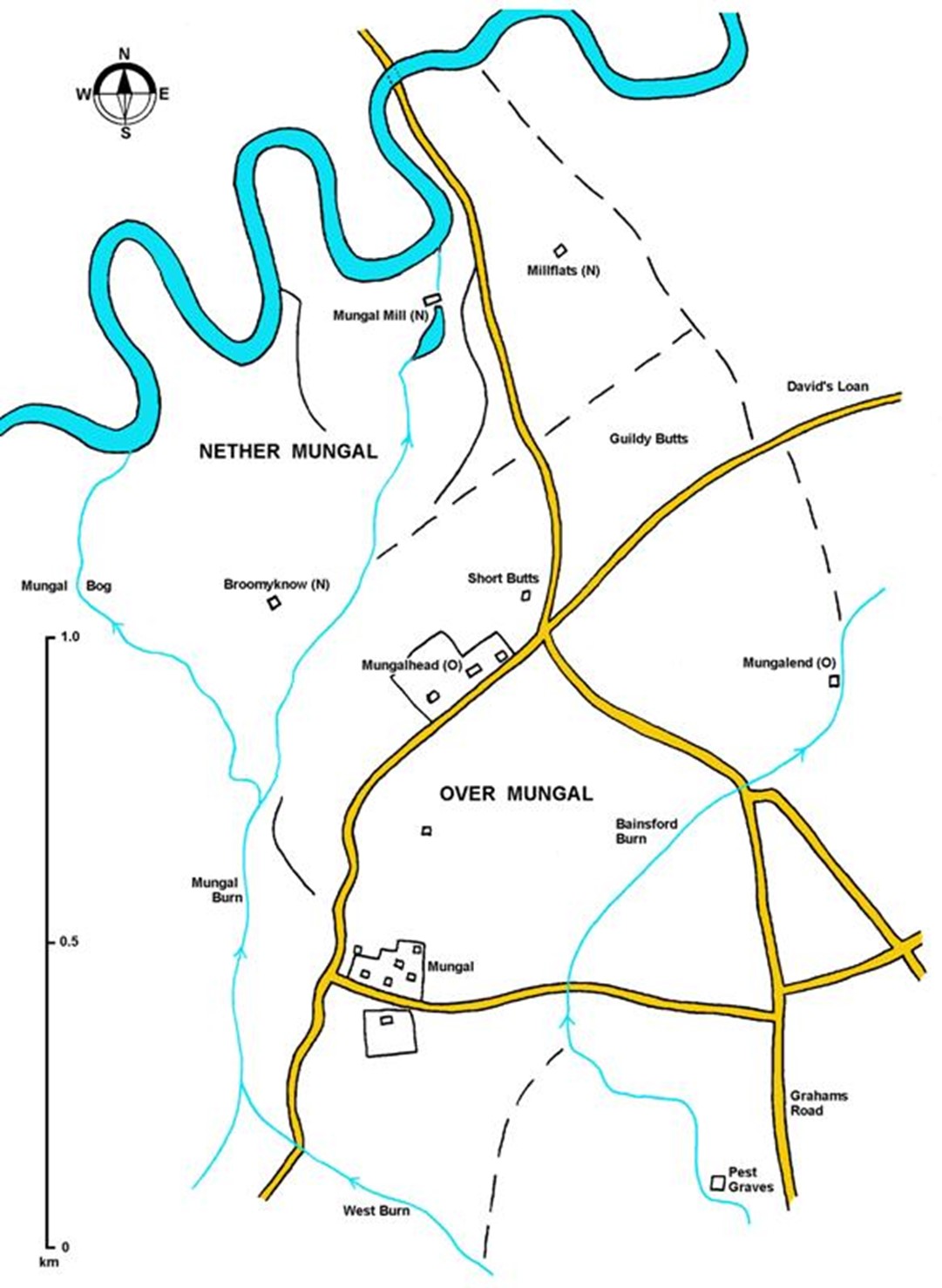
In the 15th century the extensive Lands of Mungal were part of the Barony of West Kerse. The name “Mungal” is spelled in various ways in the early documents with “Mungall” also being common. The full extent of Mungal is uncertain but it appears to have been bounded on the north by the River Carron, on the west by the Mungal Burn, on the south by the West Burn of Falkirk and the Pest or Bainsford Burn and on the east by a drain/field boundary running almost parallel and to the east of the main road from Falkirk to Carron.
Thus configured the Lands held dryland to the south sitting between 25 and 50ft OD, and floodplain in the north beside the river. The dryland has place names such as Guildy Butts, Short Butts, Crofthead, Stephens Croft and Goosedubs – all indicating intensive agriculture. The river meandered within its floodplain and occasionally changed course with the result that some of Mungal ended up lying to the north of the new river line and conversely some of the Lands of Stenhouse lay to its south. Fishing rights in the river were valuable. The Mungal Burn started in the south as the Tamfourhill Burn, becoming the Tophill Burn, and then cut through a prominent valley just to the east of Camelon. From Tophill the valley broadened and the gradient slackened resulting in a large bog, the Mungal Bog, at the intersection with the river. Reid hypothesises that Mungal is a Gaelic name meaning foot of the moss (Reid 2009, 78). The uncultivated nature of the land here is reflected in the place name of Broomyknow (a hill covered with broom), as well as Stocks (tree stumps), Burns and Meadowland. It is occasionally said that this bog featured in the topography of the Battle of Falkirk in 1298 when William Wallace was defeated by Edward I of England, but this is pure speculation.
Peat was used extensively as a fuel and so it is likely that the extent of the moss was gradually diminished over the centuries. Water was also diverted away from the bog by channelling the main flow of the burn eastward to a meander further down-river. This had the major benefit of allowing its waters to be used to drive a mill close to the point where they entered the river. Mungal Mill is mentioned in the early charters and was held by the Priory of Manuel until 1568 when Joanna Livingstone, the prioress, granted the corn mill and the mill lands to John Livingstone of Dalderse. By the end of the 15th century, and presumably long before that, the Lands were divided into Over Mungal and Nether Mungal, both of which were thirled to the mill. Although obscured by later patterns of ownership, it appears that Nether Mungal occupied the northern portion or low-lying part and Over Mungal the southern or dryland.
As with all such landownings, the shape and size of Mungal changed with time. The southernmost portion, known latterly as Burnhouse or Parkhouse, fell into the hands of the Livingstones of Bantaskine prior to 1501. In the early 17th century Over Mungal came into the possession of the Bruces of Airth by marriage to the Menteiths of West Kerse, and thence to the Bruces of Kinnaird who passed it on to the Elphinstones of Quarrel. In 1614 Sir John Bruce, with consent of Sir Wm. Monteith of Kerse, disponed 4 oxengate of Nether Mungal to Harry Guidlet (or Goodlatt), followed in 1622 by another 4 oxengate of Over Mungall (GD 237). Meanwhile, the superiority of Nether Mungal was transferred to the Regality of Callendar and in 1660 James Guidlet of Abbotshaugh was granted a charter of the eastern portion. From thence the two portions went their separate ways.
Up until 1660 the owners of Mungal held land elsewhere where they had their principal residences. Abbotshaugh now became the seat for the eastern portion of Nether Mungal. The western portion of Nether Mungal, called a half-mailing, was acquired by Alexander Sword from Robert Elphinstone of Quarrel and amounted to 8 oxengate and a cotland. The Sword family of Falkirk was very influential in that town, serving as procurators and bailies.
In 1712 David Ramsay WS of Lethandy in Perthshire bought Over Mungal with the mill and mill lands from Robert Elphinstone, who was his brother-in-law. David Ramsay then feued off small parts of Over Mungal to recoup some of his outlay and used the proceeds to buy part of Sword’s land. This included a farm which he renamed Lethandy after his Perthshire home (and which incidentally once stood on the north side of the river). It is noteworthy that David Ramsay was usually styled as “of Lethandy,” implying that he did not have a principal residence at Mungal.
The township of Mungal was essentially a hamlet – though at this period it was bigger than Bainsford. It was home to a number of tradesmen such as a wright, a mason, a maltman and even a glover. The main road through this settlement ran from Mungalend Road in the west to Gowan Avenue in the east. Close by was the road from Tophill via Mungalhead to the port on the River Carron at the Salt Pow. This was an important route and its eastern section was known as St David’s Loan. David Ramsay continued to feu land in the hamlet for development:
1740 – “compeared upon the ground of the lands underwritten John Muirhead holding a disposition granted by the deceased Mr David Ramsay of Lethendie and Michael Ramsay his eldest lawful son Mungall in favour of the said John Muirhead with the consent of Isobelle Mary and Helen Elphingstone lawful daughters to the deceased Michael Elphingstone of Quarrell and Jean Ramsay daughter to him — these parts and portions of their lands of Mungall called Burns and Stocks with the meadows thereto belonging as they were formerly possest by William Muirhead brother german to the said John and the deceased James Muirhead of [uncelance] in Tophill — conform to their tacks bounding therein specified and aftermentioned viz. by Millburn on the south and west sides untill it comes to the north side of the Stocks and then up along the Dyke or Ditch that marches betwixt the Meanbank [and?] Boighill thence threw to the northend of the Meadowland then straight south Alexander Suords march until you come to the Millburn on the east parts together with the Little Coathouse and yaird thereto belonging in Mungall as property to the said Elizabeth — with free use of road from the high road that goes through the town of Mungall and through the land called Stephens Croft to the said piece of land now called Stocks — privilidges thereto belonging and specially of casting of feall and Divotts on the Green of Mungall for building and upholding of his said Coathouse”
(Reid Notes).
The following were the children of David and Euphemia Ramsay: Michael born 1702, Rachel born 1707, James born 1708, Alexander born 1712, William born 1715, David born 1718, John born 1719, Robert born 1721, and Margaret whose date of birth is not known.
David Ramsay died around 1733 and his daughter, Jean, received an annual rent of 4,000 merks from the Lands of Over Mungal. Three years later his eldest son, Michael Ramsay, took sasine
“of all and heall these sixteen oxengate and ane cotland of lands of Over Mungall with the miln and miln lands and astricted multures of Over and Nether Mungalls fishing upon the Water of Carron”.
(Reid Notes)
There was still no mention of a principal dwelling.
Michael Ramsay used the lands now in his possession as security for loans and continued to feu land along Carron Road. In 1748 the mill and mill lands of Mungal were put up for sale, as was a small farm. The lands were described as “Improvable” suggesting that there had been no investment there for some time. The backward state of the holdings is also shown by the nature of the rent which still consisted of meal, oat straw, kain hens, capons, plough duties and the carriage of coals as well as Scots money. The lands must have failed to reach their reserve price, for in 1755 they were advertised again:
To be sold jointly and separately, the following parcels of the lands of Mungal, viz, The Miln and Miln Lands of Mungal, possest by Thomas Kaiter, paying of yearly rent 56 l, 5s Scots of Money, and 26 bolls meal, the Lands possest by Thomas Ewing, paying of yearly rent 134 l. 11s Scots, 19 ½ bolls meal, and 8 bolls of bear; the lands possest by Michael Johnston, paying yearly 50 l.14s Scots; all holden of the proprietor of the Estate of Calendar. As also, the Lands possest by James Grossart, holden of Lawrence Dundas of Kerse, Esq, and paying of yearly rent 95 l 10s, 6 ½ bolls meal, and 3 bolls, 1 firlot of bear; amounting in the whole to 337 l Scots, 52 bolls meal, and 11 bolls, 1 firlot bear, beside Kain and other casualties, converted by the tacks. The tenants pay the cess and minister’s stipend, over and above their rents, without any deduction. The rental, tacks, and title deeds, to be seen in the hands of Alexander Cunnyghame, one of the Clerks to the Signet, at his office in the Writer’s Court, to whom any person intending to purchase may apply.”
(Caledonian Mercury 19 May 1755, 3).
Sites & Monuments Record
| Merchiston House | SMR 677 | NS 8820 8079 |
| Mungal House Doocot (Merchiston Hall) | SMR 39 | NS 8816 8086 |
| Merchiston Villa | SMR 2077 | NS 8813 8108 |
| Mungal Cottage | SMR 1239 | NS 8799 8150 |
| Mungalhead House (Young’s House) | SMR 2099 | NS 8853 8149 |
Bibliography
| Love, J. | 1908 | Local Antiquarian Notes and Queries. Volume 1. |
| Love, J. | 1928 | Highways, Byeways and Biggins of Falkirk. |
| Nimmo, W. | 1770 | The History of Stirlingshire. |
| Watters, B. | 2002 | ‘The Lands of Mungal’, Calatria, 16, 69-87. |
| Watters, B. | 2010 | Carron: Where Iron Runs like Water. |
| Reports of Cases Decided in the Supreme Courts of Scotland and in …, Volume 22 1850, 299-307 |
