A canal across central Scotland had been proposed for well over a century before construction work on the Forth and Clyde Canal began. Numerous surveys were undertaken and its line slowly refined. One of the great debates was over where the eastern terminus should be located. The Carron Company, which was one of the biggest promoters of the new canal, naturally wanted it to enter the River Carron between its works and Carronshore. However, the great engineer John Smeaton pointed out that the river was already busy and that its navigation could be difficult. In response Carron Company promised to straighten the river, reducing its length and deepening the central channel allowing larger vessels to use it. The landowner further down the river preferred an entry to the Carron nearer to its debouchment into the Forth, from which he would benefit. Many of the Glasgow merchants already traded with Bo’ness and to them the port there seemed to be the obvious place to head for. It already had a large harbour capable of being entered at most states of the tide. To the people of Bo’ness this not only made sense, but they were quick to realise that the alternative would spell disaster for their existing cross-country trade.
In 1765 the short report of Robert Mackell, engineer, “Respecting the Branch-canal, to be Extended from the Termination of the Great Canal, Upon the Forth at Heuck, to the Harbour of Borrowstounness” was published. It made clear that the additional canal was viable.
Consequently representatives of Bo’ness put in a strong appearance at Westminster in 1767 during the passage of the proceedings that led to the Act of Parliament for the construction of the Forth and Clyde Canal. At that time Carronshore was still the front runner for the eastern terminus. A petition was submitted by Alexander Earl of Galloway; John Ross Mackye of Palgowan, Archibald Hamilton of Rosehall, Archibald Stuart, Writer to the Signet of Torrence, being guardians of George James, Duke of Hamilton and Brandon; and of the merchants and traders of Bo’ness, asking for the canal to be extended to that town. This extension was seen as a separate canal. A sub-committee heard witnesses who had been hurriedly assembled – the idea for making the intended Canal from Borrowstounness to Carron Shore had only taken its rise at Borrowstounness about five weeks before the hearing in March. John Forbes was a local skipper and knew the sailing conditions. He appeared and informed the panel that Bo’ness Harbour was capable of taking twenty ships of up to 500 tons burden. The tides there rose 17ft at Spring Tides and 11ft at Neap Tides, meaning that ships could enter the harbour at any time, especially as it was unaffected by land floods or frost. By contrast, at Carronshore Spring Tides rose 8 or 9ft, and at Neap Tides 5 or 6ft. Vessels of as little as 30 or 40 tons, drawing only 5 or 6ft of water, could not go up the River Carron at Neap Tides. In moderate weather, if the wind was contrary, the vessels might have to wait three or four tides, and this would be exacerbated if the river was straightened. However, with a fair wind and tide the voyage could be accomplished in as little as four to six hours. It was not unknown, he stated, for vessels to be detained four or five days, and in frosts up to three weeks. Floods on the land adjacent to the River Carron made navigation along it hazardous in the winter.
The second witness was Alexander Shepherd, surveyor, who had worked on the line for the Forth & Clyde Canal. He also referred to the proposed straightening of the River Carron, noting that if the loops were cut it would occasion a bar at the mouth where it entered the Forth. He confirmed Forbes’ opinion that a Carronshore terminus would mean that ships would not be able to sail from Leith to Greenock at all times; but that if a canal was made from there to Borrowstounness they would. Shepherd stated that the proposed canal from Carronshore to Bo’ness was to be of the same dimensions as the main canal – namely 24ft wide and 4ft deep to carry vessels of 40-50 tons. The proposed extension would be 9 miles at a contour level with the High Water Mark at Spring Tides and so would not require locks, but would need a principal bridge (over the River Avon) and two large tunnels (perhaps near Capies Point) as well as seven bridges of communication (to provide access across the canal for landowners and their tenants). It would not interfere with the water supply of any of the local mills. He calculated the cost of the canal from Carronshore to Bo’ness to be £4,510. It would, of course, only be of use once the main canal was completed and so construction on it should only commence as this was about to happen.
The cost of freight from Carronshore to Bo’ness by the Forth and River Carron made the proposed canal dues financially viable. Even more telling, the City of Glasgow and several of its merchants had already subscribed sums of money for the Bo’ness Canal. Consequently, on 26 March 1767 the parliamentary sub-committee reported its findings to the Committee considering the main Act, recommending that facility for the construction of the Bo’ness Canal should be included in a clause.
A pamphlet printed on 11 April 1767 makes it apparent that “the gentlemen” promoting the Forth & Clyde Canal did
“in the house of Commons, violently oppose the junction of a canal from Borrowstounness with theirs; though nothing is more obvious to common sense, than that the principal canal itself, with a view to general utility, ought to begin at or near Borrowstounness, and have branches only from Carron, because the navigation up that river is tedious, and often uncertain, on account of land-floods, and of shallow water in neap-tides, even for very small vessels. This is so true, that it would often happen, that a vessel entering through Borrowstounness, might be in Clyde, before another lying in the mouth of Carron could reach the intended junction of the canal in that river.”
On 8 March 1768 royal assent was given to an Act snappily entitled “An Act for the making and maintaining a navigable Cut or Canal from the Firth or River of Forth, at or near the mouth of the River Carron, in the county of Stirling to the Firth or River of Clyde, at or near a place called Dalmuir Burnfoot in the County of Dumbarton and also a collateral Cut from the same to the city of Glasgow; and for making a navigable Cut or Canal of Communication from the Port or Harbour of Borrowstounness, to join the said Canal at or near the place where it will fall into the River Carron or Firth of Forth.” The reason for including the link to Bo’ness was given as it “will make the said canal greatly more useful & beneficial by opening a shorter & more certain access thereto from the said port, and will likewise tend to the improvement of the adjacent lands and other good purposes.”
It is not certain who the main promoters of the Bo’ness Canal were at this stage, but it is clear that the Duke of Hopetoun, the Duke of Hamilton’s representatives, Dr John Roebuck, James Addison and several Glasgow merchants were amongst them. Having successfully got the project incorporated into the Act of Parliament they now needed to have a more detailed survey made and to make preliminary contact with the landowners along the proposed course. In August 1771 James Watt, who had been conducting experiments on his improved steam engine at Kinneil just two months before, was commissioned to undertake the survey. At the end of the month he walked over the ground with the canal committee. By then it was clear that the sea lock of the main canal had been fixed at Grangemouth. Watt’s full survey was carried out between 18 and 24 November with the help of John Stewart and John Osborne. Pinkerton drew the plan for the report. Watt then wrote up the report in January 1772, spending 24 days on the work and charging the company £32.2s.
The line that Watt followed for a canal 16ft wide at the bottom and 5ft deep was that initially proposed, but with a slight deviation at the River Avon. To the west of Bo’ness Harbour walling was required between the canal and the sea due to the restricted nature of the foreshore. At Capies Point it would be necessary to cut through the rock. For much of its route it then hugged the coast in order to avoid the more expensive agricultural land. However, this meant that it had to cross the Grange Burn and the River Avon on the carse land where foundations would be problematical and greater allowances had to be made for flooding. The crossing of the River Avon was to be the main civil engineering feature of the canal. In one scheme Watt proposed damming the Avon to cross it on the level, but this required too much land. His alternative was a wooden aqueduct:
“I would propose the Aqueduct to be a very strong wooden trough, Twelve feet wide, and seven feet deep, supported upon rows of strong posts which should be set upon piles driven in the Bottom of the river. It should also be braced by diagonal Shores fastened to piles and to the bottom and top of the Trough… I would propose the clear water way for the passage of the River or length of openings of the Bridge, to be one hundred & twenty feet and the height to be eleven or twelve. From what observations I have been able to make, this will be abundantly sufficient for the passage of the waters, in any state which they ever are in.
I have preferred this wooden fabric, to one of stone, principally on account of the expence, which will be much less particularly, in such precarious foundations as the Kerse lands afford.”
The aqueduct over the Grange Burn was to be 72ft long and 16ft high with arches of 18ft circumference. The direct route from Bo’ness to Sealock (Grangemouth) via Bearcrofts would be about 3½ miles, whilst a southward deviation to Jinkabouts would stretch this to just over 4 miles. Watt’s estimates for the construction were incredibly low, £2.932.9s.9 ½ d for the shorter route, and £3.210.4.6 for the longer. This, however, did not include a sea lock between the canal and the harbour at Bo’ness. Having to take into account the fall of the tides this would be an expensive undertaking and it was agreed that it could be executed at a later date once the navigation was been operating for some time. Before that, goods would have to be transhipped at the port – Watt recommended that goods be carried in the barges in carts or wheelbarrows. This made the canal less efficient and flew in the face of the ideal previously put forward for through transport from Leith to Greenock, but it should at least get the project started.
Meanwhile John Burrell, the Duke of Hamilton’s factor for Kinneil Estate, was using the plans to access the impact upon his lands:
6th Jan 1772 – “…I had yesternight a meeting with Mr — anent the Borrowstounness Canal where we opainuned Mr Pinkertons plan which shoud have represented in the Most Accurate manner the whole stiedings we took Observations off Goeing thro the Kerse But that not being the case he promised to make out such a plan himself upon me sending sum my plans of the Kinneil Kerses which plans I wrote to my son to Deliver to Baillie Coouan on Reciept for that Effect.”
He then consulted Watt:
20th Feb 1772 – “I called for Mr Watt to come with me and after that went with him to his own house and Read over the copy of his Report anents the Borrowstounness Canal whereby I find from many good Reasons that he preffers the Jinkabout Tract to any Other I thought to have taken some excerpts from his notes but as there is a Clean copy of his Report at Bo’ness before me there is the less need for the Trouble.”
The venture capital used to pay consultants and specialists to initiate the canal project seems to have come from a small number of individuals who were slow in making payment for the services provided. James Watt had to make repeated requests for payment, enlisting the help of John Roebuck junior in his quest. Even so, it was October 1775 before he received £25 and it is doubtful if he ever got the remaining £7. Other experts include the cartographer Pinkerton, the surveyor John Lowrie, and the engineer Charles Sinclair.
Progress on the Forth and Clyde Canal had initially been rapid, but west of Kirkintilloch the pace slowed. It was therefore 1782 before the advocates of the Bo’ness Canal felt that the time was right to begin work on the ground. £5,000 had been promised in subscriptions from investors based mostly in Bo’ness and Glasgow, with a further £3,000 if necessary to complete the project. These now formed the Company of Proprietors of the Borrowstounness Canal Navigation. In November a General Meeting was held in the Duke of Hamilton’s Arms Inn at Bo’ness “to take such measures as may appear necessary for beginning the Canal as soon as possible.” Sir Robert Dalyell, Johnstone of Straiton, Dr John Roebuck, James Addison, James Tod, and James Dalgleish were duly elected as a committee of the Borrowstounness Canal Navigation for ordering surveys and estimates of the intended canal, with Roebuck as the convenor. John Christie was appointed as the clerk. According to the parish minister, Robert Rennie, the estimate for the canal was now set at £12,000. An amendment was therefore needed to the Act of Parliament and in 1783 a second Act was procured setting the subscription limit to £12,000 with the possibility of a further £4,000. The Act gave provision for enabling the Proprietors of the Canal to borrow money upon the credit of the tolls arising upon the said Cut or Canal. Subscriptions for £10,000 were quickly proffered.
On 12 March 1783 the following advertisement appeared in the Caledonian Mercury and the Manchester Mercury:
Contractors are wanted for executing this Canal from Sea-Lock to Borrowstounness, of the following dimensions:
The length is about 5 ¾ miles, to be seven feet deep, with a bank of two feet above the water level, twenty four feet wide at bottom, and forty eight feet wide at the surface of the water.
As it is proposed to begin this Canal without delay, offers must be lodged for executing that part of it from near the first Land Lock of the great Canal to Grange Burn, being about three fourths of a mile, on or before Saturday the 29th March current.
Proposals for executing the other part of this Canal from Grange Burn to Borrowstounness will be received on or before the 29th April next, and these may either be for finishing the whole tract, or for one or more of the following lots:
Lot No 1. From Sea-Lock to Grange Burn, as above.
No. 2. Grange Burn, with a damhead, and banking.
No. 3. From Grange Burn to Candy.
No. 4. From Candy to Avon Water.
No. 5. Aqueduct bridge, to be built on dry land.
No. 6. From the Aqueduct Bridge to Andrew McVey’s Farm.
No. 7. From Andrew McVey’s Farm to Parknook.
No. 8. From Parknook to the Snab.
No. 9. From the Snab to the West Engine.
No. 10. From the West Engine to the Bason.
No. 11. The Bason and Lock to communicate with the Harbour of Borrowstounness.
The soil from the first Land Lock of the Great Canal to Parknook, (nearly four miles) is a deep clay, all in the Kerses of Falkirk and Kinneil. The soil from Parknook to the Harbour of Borrowstounness, is various, consisting of clay, gravel, free and whine stone rock.
As the sea, in spring tides, will rise seven or eight feet on the north side of the canal, for about eight hundred, or one thousand yards, a wall or bank must be built to fence out the same.
For further particulars, and for a proper person to shew the plan and tract, apply to John Christie, canal clerk, at Borrowstounness, with whom the proposals are to be lodged, sealed up.
Priority had to be given to the construction of the two main structures over the River Avon and Grange Burn as these would take the longest to execute.
“Two AQUEDUCT BRIDGES, & c To be BUILT, CONTRACTORS are wanted, for Building an AQUEDUCT BRIDGE OF SIX Arches, over Avon River, and one of two Arches over Grange Brook, both for the Borrowstounness Canal Navigation, from the Sea Lock on the Main Canal, to the Harbour of Borrowstounness, from which it is to communicate by a Sea Lock. The greatest part of the cutting of the Canal is already contracted for, and is going forward; but some Lots are yet to contract for, consisting mostly of Sea Banking, and Sea Walls, that will cost above Two Thousand Pounds, besides several Passages, Bridgets, and Stop-Gates.
Plans and Regulations may be seem in the Hands of Mr John Christie, the Canal Company’s Clerk, at Borrowstounness, after the 15th current, with whom any may correspond: The Plans and Proposals for executing the Work, must be lodged with him on or before the first of August next.
NB. Both the Aqueduct Bridges are to be built on dry land, which, when finished, Avon River and Grange Brook will be cut, and let through them.
Excellent FREE-STONE is to be had for the bridges, for the Sea Banking, Sea Walls, and Sea Lock, at a small Distance.”
(Manchester Mercury 22 July 1873, 2)
Watt’s idea of a timber aqueduct over the Avon was clearly impracticable and even his alternate route by Jinkabouts was abandoned. Work had begun amongst an air of cautious optimism and bills now had to be paid. At the beginning of the year the subscribers were asked to pay 10% of what they had pledged, followed by a second call for the same amount in the summer. The second General Meeting was held at Bo’ness in 19 August 1782 with the Earl of Hopetoun in the chair. It called for the third payment of 10%. All of the payments were to be made to Sir William Forbes, James Hunter and Co, the canal company’s bankers in Edinburgh, or to John Christie in Borrowstounness. Progress was such that quarterly meetings were held on 23 September, and then on 17 February 1784. The clerk was authorised to take legal action against those failing to heed the calls for payment.
Digging the tract eastward from the River Avon was progressing well and the adventure was the subject of much conversation. On 22 January 1784 James Forbes at Callendar House wrote to his brother William in London:
“I dined with a Boroughstoness writer at Dearn’s who was speaking about the new canal. It is to be carried over the Avon by a bridge or rather the bridge is to be built on dry ground and the Avon is to be taken out of it’s course for a little way and brought under the bridge upon the lands of the Duke of Hamilton who subscribes to the canal… I must see it myself.”
(Forbes papers 172/1).
More details of the remaining work were advertised in March:
“AQUEDUCT BRIDGES, and other work, Done on Contract for the BORROWSTOUNNESS CANAL NAVIGATION. That Plans of Aqueduct Bridges being fixed on at a general meeting of the Borrowstounness Canal Company, met this day, to cross Avon water, on three elliptic arches of 30 feet long diameter, by 12 feet perpendicular each, – and Grange Burn on one elliptic arch of 42 feet by 12. Notice is hereby given to architects, engineers, or others, that the proper plans are in the Canal Clerk’s office, John Christie, at Borrowstounness, and at Mr James Smith’s writer in Edinburgh, the Company’s agent, and such as chuse to contract for either or both Bridges, will lodge their estimates, shewing the lowest sum they will execute the work for, with said Mr Christie, sealed up, on or before Tuesday morning the 23rd curt, to which time the General Meeting stands adjourned. Also, That such as chuse to contract for digging and cutting Lots No. 8 & 9 of said Canal, being from Parknook to West Engine, will lodge their proposals and offers with said Mr Christie, on or before Tuesday morning the 16th curt. when the Committee meets on that business.
(Caledonian Mercury 15 March 1784, 1; Edinburgh Evening Courant 15 March 1784, 1a).
It has been suggested that David Henderson, architect, acted as a civil engineer for the Bo’ness Canal Company (p.183) for the bridge (Gow 1998, 183).
A list of subscriptions to 12th Nov 1784 survives and is of interest not only because it shows that £10,150 had been promised and £2,055 paid, but because of the names of those who contributed. These included landowners, merchants, businessmen and skippers:
| NAME | SUBSCRIBED | PAID |
|---|---|---|
| Duke of Hamilton | £500 | – – – |
| Earl of Hopetoun | £100 | £40 |
| Countess of Hopetoun | £100 | £40 |
| Lady Ann Hope | £100 | £40 |
| Lady Elizabeth Hope | £100 | £40 |
| Lady Georgina Hope | £100 | £40 |
| Lady Jemima Hope | £100 | £40 |
| Lady Lucy Hope | £100 | £40 |
| Sir William Augustus Cunningham | £500 | – – – |
| Robert Cunningham | £50 | – – – |
| David Cunningham | £50 | – – – |
| James Cunninghame | £50 | – – – |
| Hon Charles Hope ver | £50 | £10 |
| David Dundas | £100 | £50 |
| Sir Robert Dalyell | £50 | £20 |
| Robert Clark | £50 | £15 |
| Alexander Learmonth | £50 | £5 |
| James Smith Bewick | £50 | – – – |
| Henry Dundas | £100 | – – – |
| Robert Dundas | £100 | – – – |
| Alexander Johnston | £100 | £20 |
| Miss Walkenshaw | £50 | £15 |
| William Thomas Wishart | £100 | £30 |
| Earl of Buchan | £50 | £5 |
| William Napier | £50 | £25 |
| James Taylor | £50 | £15 |
| William Gilles | £50 | £15 |
| Robert Stewart | £50 | – – – |
| William Baillie | £50 | £5 |
| James Hope Baillie | £50 | £5 |
| Earl of Roseberry | £150 | £15 |
| Captain John Stone | £100 | £10 |
| Duke of Buccleugh | £200 | – – – |
| Edward Addison | £100 | £50 |
| Geo Gun Munro | £100 | – – – |
| Alexander Donald | £100 | £100 |
| McAlpin Fleming & Co | £100 | £20 |
| Dr Roebuck | £150 | £15 |
| John Roebuck | £100 | £10 |
| £3700 | £735 | |
| John Burrel | £50 | £20 |
| John Boyes | £50 | £20 |
| Mrs Stuart | £100 | £20 |
| Miss Roebuck | £50 | £10 |
| Jonah Roebuck | £50 | £5 |
| Joseph Roebuck | £50 | £5 |
| William Roebuck | £50 | £5 |
| James Addison | £200 | – – – |
| James Grierson | £200 | – – – |
| Charles Addison | £200 | – – – |
| John Cowan | £200 | £80 |
| James Dalgleish | £150 | £60 |
| James & Andrew Tod | £200 | £60 |
| John Short | £100 | £40 |
| James Drummond | £100 | £20 |
| Thomas Grindlay | £100 | £10 |
| James Johnston | £100 | £10 |
| Thomas Paden | £100 | £30 |
| James Grindlay | £100 | £40 |
| Edward Cowan | £100 | £10 |
| William Baird | £50 | – – – |
| Robert Henderson | £100 | £10 |
| John Bain | £50 | £10 |
| James Thomson | £50 | £5 |
| Thomas Cowan | £100 | £10 |
| Andrew Cowan | £100 | – – – |
| John Christie | £100 | £10 |
| James Smith | £100 | £10 |
| Peter Lawson | £50 | £5 |
| James Donald | £50 | £20 |
| Robert Grindlay | £50 | £20 |
| James Addison Snr | £50 | – – – |
| James Baird | £50 | £10 |
| James Aitken | £50 | £5 |
| James Dobbie | £50 | £5 |
| Robert Paterson | £50 | £5 |
| William Robertson | £50 | £20 |
| Milne & Graham | £50 | £5 |
| John Snadden | £50 | £5 |
| £3500 | £600 | |
| Henry Rymer | £50 | £20 |
| Margaret Paden | £50 | £15 |
| James Thomson | £50 | £5 |
| James Melville | £50 | £5 |
| Robert Duncan | £50 | £10 |
| Lady Hamilton | £50 | £10 |
| William Smith | £100 | £40 |
| James Coke | £100 | – – – |
| Alexander Buchanan | £50 | £5 |
| Robert Smart | £50 | £5 |
| Robert Hart | £100 | £10 |
| William Andrew | £50 | £5 |
| Charles Sinclair | £100 | £10 |
| Loudoun Craigie & Co | £200 | £80 |
| Robert Cowan | £100 | £20 |
| Andrew Cowan jnr | £50 | £10 |
| James Harroch | £100 | £20 |
| James Robertson | £50 | £20 |
| David Dale | £50 | £10 |
| William – – | £50 | £10 |
| David Ryane | £50 | £20 |
| William Keay | £50 | £20 |
| John Taylor | £50 | £20 |
| James Hunter | £100 | £40 |
| John Glassford | £100 | £20 |
| Alexander Spiars | £100 | £20 |
| Earl of Home | £100 | – – – |
| Duke of Argyll | £100 | – – – |
| Duchess of Argyll | £100 | – – – |
| Elizabeth & Thomas Gillespy | £100 | £20 |
| Simpson & McLean | £50 | – – – |
| Roger Hog | £50 | £25 |
| Captain James Ferguson | £100 | £20 |
| Archibald Campbell | £100 | £50 |
| E Clark | £100 | £50 |
| Collen McKenzie | £100 | £50 |
| John Black | £50 | £5 |
| £2950 | £720 | |
| £3500 | £600 | |
| £3700 | £735 | |
| £10,150 | £2,055 |
The expenditure to 12 November 1784 had been:
| “Cash paid John McArthur to accounts of cutting Lots no 6 & 7 of the canal from Avon Water to Parknook | £401 | 15 | 11 |
| ditto paid sundrys for digging the aqueduct bridge feet | 419 | 15 | 5 |
| ditto paid James Dalgleish to account of timber furnished for the feet amounting as per account to £134.-2 paid | 50 | ||
| ditto paid Messrs Easton & Scott in full for laying the platform as per agreement | 105 | ||
| ditto paid them to account for building the bridge in terms of contract | 175 | ||
| 749 | 15 | 5 | |
| ditto paid James Johnston to account of cutting Lots 8 & 9 from Parknook to the West Engine amounting to | 205 | ||
| ditto paid Alexander Buchanan for making a new road from Parknook to the Snab | 58 | 12 | |
| Ditto paid David Nimmo to account of building a new dyke from ditto to ditto | 103 | ||
| Ditto paid John Lawrie’s account for surveying and making plans & estimates of the canal amounting to | 89 | 14 | |
| Mr Sinclair’s account for ditto £45.5.7 paid | 20 | ||
| Paid Mr Spottiswood to account for expenses of procuring a new Act of Parliament | 160 | ||
| paid land damage to Kinneil tenants | 61 | 15 | 9 |
| ditto paid the Committees expenses & chaise hires for sundry journeys to Glasgow, Hamilton & Dunbar & c | 39 | 8 | 1 |
| ditto paid to Messrs Wright, Elliot, Heald, Shaw & Parkhill & c | 20 | 9 | 6 |
| ditto paid for advertisements in the newspapers | 19 | 12 | 10 |
| ditto paid James Simpson for books & c furnished | 2 | 18 | 6 |
| ditto expenses for postages, expresses, stamps, Mr Bains Betts with sundry other charges amounting to | 34 | 9 | 7 |
| 448 | 8 | 3 | |
| balance in the hands of Sir William Forbes & Co | 22 | 16 | 1 |
| ditto of cash remaining in the hands of John Christie | 80 | 18 | 1 |
| 1966 | 11 | 7 | |
| 2070 | 6 | 1“ |
It will be seen that a fair proportion of the money had gone on professional fees. At some point in 1785 James Addison replaced the Earl of Hopetoun as chairman of the company. Further calls were made for payments of 10% of the promised amount:
- The 1st call due 15th March 1783
- 2nd call due 16th August 1783
- 3rd call due 16th November 1783
- 4th call due 16th April 1784
- 5th call due 16 July 1784
- 6th call due 16th November 1784
- 7th call due 11th March 1785
- 8th call due 11th June 1785
- 9th call due October 1785
- 10th call due 29th December 1785.
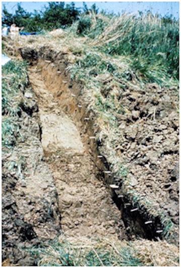
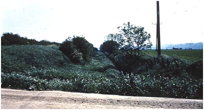
Illus 4: 1969 Excavation by the West Lothian County History Society showing the Clay Puddle lining the side of the Cut.
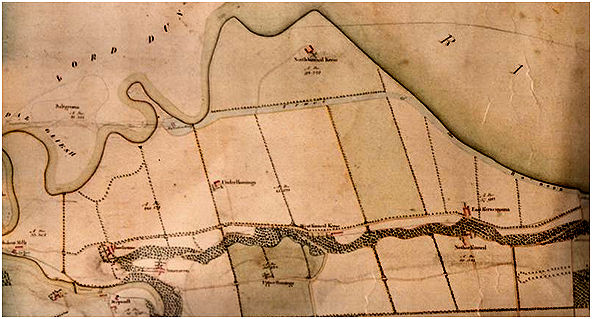
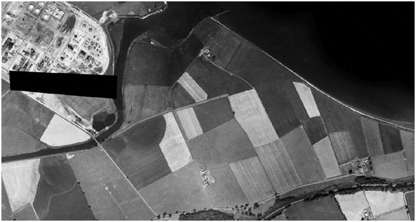
By mid November 1784 the foundation pits for the Avon Aqueduct had been excavated by John McArthur and his gang. A timber raft had then been laid in these by James Dalgleish’s team and then the undertakers for the aqueduct, Easton and Scott, had made a fair start on the foundation and superstructure. The cut for the canal had been excavated and puddled all of the way from the River Avon to the West Engine near Capies Point. Clay was readily available from the cut itself. It must be remembered that the shoreline at the time was much further inland than it is today. Where the foreshore was narrow the existing shore road had had to be replaced from Parknook to the Snab by a new one to make room for the cut. As this coincided with the Kinneil Policy, a rather expensive boundary wall had been built along the south side of the road.
Having got the canal to Capies Point, work concentrated on the next leg to the east and in April 1785 Lot 10 was re-advertised:
Contractors wanted for the Bo’ness Canal. “To be let on contract, Lot no X being from the West Engine to the Old Engine, at the west end of Bo’ness. This lot only measures about 500 yards in length, but, as a great part of it is several feet within the sea mark, a good deal of strong masonwork and sea-banking on the north side will be necessary.” Bids to John Christie, clerk. Further information to Charles Sinclair engineer to the canal.
(Edinburgh Evening Courant 9 April 1785, 1b).
Thoughts were also given to the more straight forward section to Grangemouth. Here the major feature was the aqueduct over the Grange Burn and from the published descriptions it is clear that the plans were modified several times:
“CONTRACTORS WANTED FOR THE BORROWSTOUNNESS CANAL NAVIGATION. To be Let on contract, the Building of an Aqueduct bridge of three elliptical arches over Grange Burn. Plan of the Bridge to be seen in the hands of Mr Charles Sinclair at Snab, engineer for said Canal; and such as chuse to undertake the execution of said work, will give in their proposals and lowest offers to John Christie the Canal clerk at Borrowstounness, betwixt and Tuesday the 26th current.
(Caledonian Mercury 9 July 1785, 1).
Proposals will likewise be received by the said John Christie, from undertakers, for shoeing with stones or otherwise, the North Bank of said Canal, from the West Engine to Parknook dyke. The mode of executing the same will be shewn by said Mr Sinclair; and the proposals for this work to be given in on or before the 26th current.
By February 1786 no undertaker had been appointed and the description of the structure had changed to consist of two elliptical arches, 14 by 21 ft (Edinburgh Evening Courant 25 February 1786, 3c). The deadline for submissions had to be extended several times. Part of the problem seems to have been that the Canal Company had gained a reputation as a bad payer and this may have been the reason that in April it tried to take direct control of the excavation of the cut towards Bo’ness.
“Borrowstounness Canal Navigation. “Wanted immediately, a number of good workmen to cut and bank part of Borrowstounness Canal, which will be let in lots from 10 to 100 yards long, and payments made once every fortnight.” Apply to Charles Sinclair, engineer, Snab.
(Edinburgh Evening Courant 10 April 1786, 1c).
The General Meeting on 25 April 1786 considered the propriety of opening a cash account with a banker in Edinburgh. It was thought that a further £5,000 would be sufficient. This gave the Canal Company new impetus and with a changed, but much more detailed, design for the crossing of the Grange Burn they pressed ahead:
(Caledonian Mercury 28 December 1786, 4).
“An Undertaker Wanted, to build an AQUEDUCT BRIDGE for carrying the Borrowstounness Canal over Grange Burn, near Grangemouth.
THIS Bridge is to consist of one arch 30 feet span, and the arch to spring six feet from the top of the land-stools or abutments. The Land-stools are to be seven feet high from the bottom of the foundation course, and the foundation course to project six inches beyond the rest of the building. The depth of the pend-stones are to be two feet, and the building above these 9 ¼ feet to the top of the tracting path, so that the total height of the Bridge, excluding the parapet walls, will be 24 feet. The parapet walls above ditto are to be three feet high, and one foot thick, including the copestone, which is to project two inches over upon each side. The thickness of the land-stools are to be seven feet each, exclusive of three counterferts from each, consisting of three feet more in length, and four feet thick, and these landstools and counterferts are to be raised to the height of the crown of the arches, therefore the length of the Bridge across the stream, exclusive of the wing wall, will be 50 feet. The Bridge is to have no sterling points. The breadth of the Bridge at the found up and down stream is to be 41 feet, exclusive of the projection of the foundation course, and to have a batter of six inches upon each side to the top of the tracking path, where the Bridge is to be 4- feet neat over the retaining walls. The building on the outside of the Bridge is to be 4 feet in thickness, next which there are to be 2 1-halp feet in thickness of puddle earth, and on the indie of which there is to be 2 one-half feet of stone work next to the water in the aqueduct; so that the tracting path will be nine feet broad, before the parapets be put on. – The building and puddle is to be the same on the other side, therefore the breadth of the canal waterway on the bridge will be 22 feet at top, and only 20 feet wide at bottom; so that the thickness of the building and puddle at the crown of the arches will be 10 feet. For the whole length of the bridge across stream, there are to be laid six inches thickness of cement, as also for the whole breadth of the waterway, and six inches more upon each side, to render the bridge perfectly watertight, and the whole of the outside and inside of the building to be laid in the beds and joints of the stones for nine inches, with the best mortar that can be prepared from Puzellana or Dutch Terras, and the rest of the mortar to be made from the best lime-shells, fresh-water sand, and fresh water, and the whole to be run solid with this kind of mortar. The wing-walls are to be nine feet long each, built with very large ruble stones, and for six inches inward is to be laid with puzzellana or Dutch Tarras mortar. These walls to be 3 one half feet thick at bottom, and to decrease in thickness to 1 one-half feet at top, which is three feet below the water-line, so their medium height will be 14 feet.
The Bridge is to be built with large stones from 10 to 15 inches thick, from 15 to 20 inches broad, in the bed head from 20 to 30 inches long, with bandstones of large sizes, but none of them are to be hewen on the outside, only to be squared, laid in regular courses, having a droved draught round the beds and joints, and the beds and joints droved for at least a foot inwards, and full for that length.
Longannet quarry lies about two miles distant by water northward from the stance of the intended Bridge, by which stones can be brought in vessels to within a short distance of it, and the Polmont quarry lies about two miles distant from it on the south, from whence stones may be got by land carriage.
The plan, elevation, and section of the bridge, are in the hands of Charles Sinclair at Snab, engineer for the Canal Company, who will give every further information that may be required by the people intending to be undertakers.
The Committee for the Canal require that such as chuse to undertake to build the Bridge, (and uphold it for seven years on security) will give in their lowest offers, directed to the Committee of the Borrowstounness Canal, on or before Tuesday the 23rd January next; and by that day se’ennight, the Committee propose to fix with such persons whose offer shall be the lowest; it being understood that the Contractor they agree with, is to be of good character, experience and ability in his possession, and to find sufficient security for the execution of the work.
£7,500 had already been spent and finance was going to be difficult; subscribers were to be chased. In some cases this led to unprecedented areas of the law. One famous verdict came in 1791 in the case of the Borrowstounness Canal Company against Macalpine, Fleming & Co. The latter had formed a copartnery in 1774 for the manufacture of printed linens on Leven. Macalpine was the book-keeper and acting partner, residing at the place of the manufacture. In 1783, Addison, correspondent of the Macalpine, Fleming & Co at Borrowstounness, subscribed in their name for two shares, of £50 each, in the Borrowstounness Canal Navigation; and, in the Act of Parliament soon after obtained for increasing the capital of that society, the names of Macalpine, Fleming and Company were inserted among the proprietors. Addison likewise attended as their proxy the several meetings of the proprietors, and two calls of ten per cent of their subscribes stock were paid to the Borrowstounness Canal Company, and receipts taken in the name of Macalpine, Fleming and Co, in whose books these payments were entered by Macalpine. The partners of the Company of Macalpine, Fleming and Co, came to a resolution to dissolve the copartnery, which was accordingly done on the 24 November 1784, but no intimation thereof was given to the Canal Company, who soon after pursued the Company, as if still existing, for the remainder of their subscribed stock. The individual partners urged in defence that they had never empowered Macalpine to subscribe to the canal navigation, and that they knew nothing of the matter; that he had taken this liberty at his own hand and was alone responsible. The Lords of Session were of the opinion, that an acting partner had power to bind the society in all matters of ordinary administration; and although this adventure might be considered as not strictly falling under that description, yet, in the circumstances of the case, the consent of the partners was to be presumed and therefore found that the whole were bound. (Scottish Court of Session (13 June 1791 Fol. Dic.v.4.p.286)
At this critical stage there were a number of changes to the personnel. James Addison died and Lord Hopetoun eventually took his place as chairman. John Christie the clerk left and was replaced by James Glover, and the agent James Smith of Bonside was also replaced. No contractors came forward and the enthusiasm and optimism had disappeared. It was time to take stock. In a brief reference to the reason for the stoppage, Mr Johnston of the Seabox Society wrote “No doubt want of funds was one of them, but, if local tradition speaketh truth, a portion of the money raised was not expended as it ought to have been, and some associated with the project rendered themselves richer in pocket and poorer in character by their conduct at that time.”
It was resolved to get a competent engineer to review the project and the obvious candidate was the celebrated Robert Whitworth who had completed the construction of the Forth and Clyde Canal. His long report was printed on 28 December 1789. It describes part of the work already undertaken and that which was still required. Here is an extract:
“From the Avon aqueduct to Parknook the canal has been finished for seven feet water; but as it has now to be raised to eight feet, the puddle will want raising on both sides the whole way. The south bank is rather slender, it having been formed with great economy for only seven feet, yet has stood so long to consolidate that it may sustain eight feet without enlarging the base.
From Parknook to the Snab garden the bank has been a good deal cut away, and will be attended with a good deal of trouble and expense to replace it.
In passing the Snab there are two ways of doing it. One is round the house and through the offices, which appear to be two pretty good new buildings which would be entirely destroyed. The other is through the garden as represented on the plan and profile. Which of these will be cheaper and more eligible I cannot well say. The latter is more direct and out of the way of the sea. For the present I will suppose the line drawn upon the plan to be adopted and the canal to be finished in the direction already begun to Copess Point, opposite the West Engine.”
“From the West Engine to the harbour will require some consideration. There are two ways for it to go. One is through the Salt Works; the other on the outside of the Bucket Pan, which will, of course, take considerable hold of the sea, and will require a strong and high wall to defend it; yet I have no doubt of its being practicable, but will be very expensive.
If there was room to carry it through the Salt Works without taking down some of the principal buildings, and I fear almost destroying the works, it most certainly would be desirable, but I cannot find there is. Indeed, if the worthy proprietor was consenting, perhaps the works that stand in the way might be rebuilt in another place at a less expense than the difference of the two sea walls necessary to defend the canal; but of this I am not certain. I can make no calculation of the line through the Salt Works, therefore for the present I will suppose it to go on the outside of the Bucket Pan, where, I trust, I can be more certain in my calculations.”
Whitworth also reported minutely on the various sources which would require to be tapped along the route to supply the canal with water, but he was relying also on a fair supply from the Great Canal. He closes the report by saying — “If the works be planned and set out with judgment and conducted with economy, I believe the canal may be completed at the following estimate” which amounted to an additional £17, 763.10.0. Of this £10,406.7.6 was to complete the section from Grangemouth to Capies Point and the remainder from there to Bo’ness Harbour. The latter included the cost of a sea lock and other expensive items connected with the terminus. This was almost double what had already been spent.
At a general meeting held on 29 December 1789 the report was presented to the canal proprietors by Lord Hopetoun. It required time for them to digest its contents and meaning and so the meeting was adjourned, initially until 8 January 1790, and then on numerous subsequent occasions. Writing his contribution about the parish of Bo’ness for the Statistical Account in 1796 Rev Robert Rennie still had faith :
“the work was relinquished, till new funds should be raised, which unfortunately have never yet been procured, and when they shall be obtained, is at present uncertain. The return of peace, with a reviving commerce, may perhaps encourage former subscribers, or animate new ones, to finish a work of public utility; and which would be of so much local advantage to this town and the adjacent country.”
However, that August a quarterly meeting of the Proprietors of the Borrowstounness Canal Navigation held in the Hamilton’s Arms Inn had under consideration:
“whether the Canal can or should be wholly relinquished, and its concerns winded up – Or whether the Scheme should be kept open in the hope of more funds for the completion.”
There was evidently a heated discussion with a handful of ardent supporters wanting to continue. The meeting was adjourned and reconvened on 1 September 1796 when, according to the newspaper report:
“there was under consideration a memorial, laid before two eminent counsel, on various canal matters, but particularly this important one – “Whether a Majority in point of interest can oblige the Proprietors to abandon and wind up, if the Minority cannot produce funds for the completion.” And the answer on this point: – “We are of opinion that, it is not in the power of a Minority to prevent the Majority from abandoning the work and winding up, unless the Minority can produce funds for finishing the canal.”
The meeting proceeded to deliberate on this opinion, and on the two states of the question proposed at last meeting for their consideration, “Whether the canal should be wholly abandoned, and its concerns winded up; or whether the scheme should be kept open, in the hope of more funds for the completion, and matters so arranged so as to occasion little future expence, and greater security against damages:” And agreed unanimously, that it was expedient to abandon the canal, and wind up its concerns. But far from wishing to precipitate a business of such importance, resolved that the vote of today should be held of no effect, further than expressing the sentiments of this meeting, and that full time might be given to absent proprietors either to join with this day’s meeting, or provide funds for completing the canal, the final decision was adjourned until the general quarterly meeting on the third Tuesday of February next, which is hereby timeously advertised, to be held at the Duke of Hamilton’s Arms Inn, Borrowstounness, at noon, for determining this important question. Borrowstounness, 16th August 1796.”
(Edinburgh Evening Courant 1 September 1796, 4c).
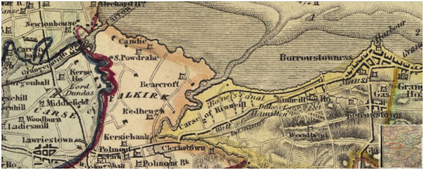
Illus 8: The Line of the Bo’ness Canal at Kinneil Kerse in 1967, looking east.
It was August 1806 before the decision was enforced at the final general meeting. The last words on its demise should go with the parish minister of 1843, Robert Mackenzie:
“The circumstances which prevented the accomplishment of this desirable undertaking need not be stated [shame]; but they were, and still are, deeply regretted by the inhabitants of this town, especially on seeing their trade turned into another channel. Much of it passed by the canal direct to Glasgow, and the larger vessels discharged at Grangemouth, which was only a creek of this port, but then became its rival, and was eventually erected into a separate port.”
Businessmen and those involved in the maritime trades moved away from Bo’ness – many of them to Grangemouth. Commercial trading at Bo’ness slowly slipped away and was eventually replaced by manufacturing.
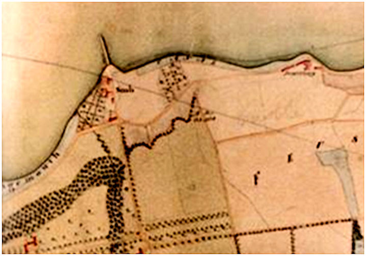
With no money to fill it in, the Cut was left open. The aqueduct bridge beside the River Avon had almost been completed and now stood beached on the east bank like a stranded whale – a decaying monument to a failed enterprise. An estate plan of 1810 shows it occupying a narrow neck of land between two loops in the river. In June 1815 James Wyse, mason in Falkirk, and John Gibb, mason in Linlithgow, reported on the value of the bridge. Their reason for doing so after so long a gap is uncertain, but it may have been in preparation for a new road from Grangemouth to Bo’ness. Travellers between the two towns still had to go via Polmont. Late in 1829 an application was made to Parliament for leave to bring in a Bill to make a road “from Grangemouth, to join the Cleugh Road at or near Hainings, in the county of Linlithgow, and to erect the necessary Bridges over the Grange Burn and Avon; and which line of road lies in the parishes of Falkirk and Polmont, and county of Stirling.” The aqueduct bridge was repurposed and finally completed, but it was 1840 before the river was straightened so that it passed under it. It is a beautiful and elegant structure belying its troubled past. In 2010 engineers from the adjacent refinery cored it in order to assess its structural strength for taking heavy loads from Grangemouth Docks to the new KG Plant at Kinneil Kerse. They were surprised to find a trough of earth under the bed of the road – until they consulted the local archaeologist!
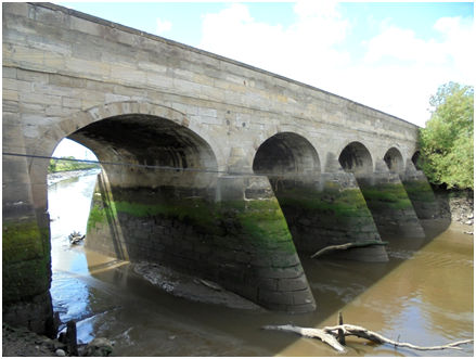
The construction of the KG Plant removed most of the other traces of the canal and so this magnificent bridge is, after all, its abiding monument.
Proposed Dimensions of the Bo’ness Canal
| Date | Depth (ft) | Surface width (ft) | Basal width (ft) | Other |
|---|---|---|---|---|
| 1767 | 4 | 24 | – – | |
| 1771 | 5 | – – | 16 | |
| 1783 | 7 | 48 | 24 | 2ft bank above water level |
| 1789 | 8 | 54 | 27 |
Estimates for the Canal:
1767 £4,510 (Shepherd) – from Carronshore
1771 £2,932.9s.9 ½ d (Watt)
1782 £12,000 (Lowrie)
1789 An additional £17,783.10.0
BIBLIOGRAPHY
Archives:
| Burrell’s Diary | |
| Forbes Papers | Held at Callendar House, Falkirk |
| Great Britain House of Commons | Journals of the House of Commons, Volume 31, p.256. 26 March 1767. |
| Hopetoun Papers | National Records of Scotland, Acc.4237 |
| Considerations Upon the Intended Navigable Communication Between the Friths of Forth and Clyde. 11 April 1767. | |
| Newspaper reports from the Caledonian Mercury, Edinburgh Evening Courant and Manchester Mercury. | |
| Plan of the Estate of Kinneil in the County of Linlithgow | belonging to His Grace Archibald Duke of Hamilton and Brandon surveyed by R Bauchop. 1810. |
Published Sources:
| Gow, I. | 1998 | ‘David (or John?) Henderson’s Designs for Caprington Castle,’ in Gow, I. & Rowan, A. Scottish Country Houses 1600-1914, 181-192. |
| Hills, R.L. | 2002 | James Watt, Volume 1: His Time in Scotland, 1736-1774. |
| Mackenzie, K | 1843 | Parish of Borrowstownness, New Statistical Account of Scotland. |
| Rennie, R. | 1796 | Parish of Borrowstounness, Statistical Account of Scotland. |
| Salmon, T.J. | 1913 | Borrowstounness and District. |
