
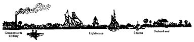
Orchards were common in the carse lands of the parishes of Airth and Bothkennar and these rich soils led to the creation of a number of small estates. Orchardhead lay at the head of the River Carron where it debouched into the Forth until 1783 when its course was artificially altered. Up until then the mansion at Orchardhead was used as a seamark to guide vessels into the river mouth and as late as 1851 it appears on Admiralty charts for the new channel. The name “Orchardhead” is mentioned as early as 1526 (Reid 2009, 220).
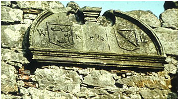
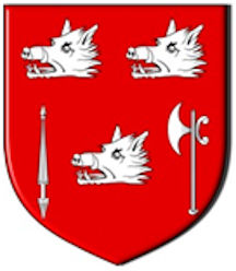
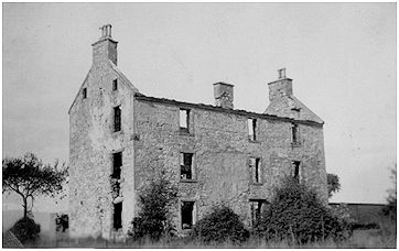
Being a small estate it is difficult to recover a complete record of its owners and tenants across the centuries. In the late 16th century it is associated with the Mure family of Grange of Bothkennar, though they may well have been tenants of the Rankines of Orchardhead. William Rankine was there in the 1670s. His son, Walter Rankine, married Sarah Little in 1665 at Liberton, Midlothian. The mansion at Orchardhead, often described as a laird’s house, was probably built in 1678, which is the date on a large round-headed dormer pediment that was built into it. The date occurs in the tympanum of the pediment between two shields; the dexter shield was flanked by the initials “W R” and had a Lochaber axe for a crest, charged three boars’ heads erased, two and one, in dexter base a lance and in sinister base a Lochaber axe, all within a bordure. The sinister shield, flanked by the initials “S L,”was charged a saltire within a bordure. All letters and figures are in relief. The arms and initials were evidently those of Walter Rankine of Orchardhead and his wife, Sara Little, who died in 1687. It is probable that the pediment may have occupied a prominent central position on the head of the stair-tower. The date is appropriate for the style of house.
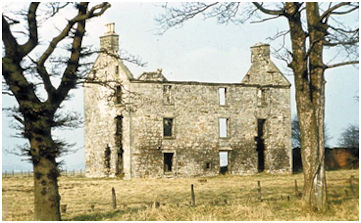
The dwelling was L-shaped in plan and consisted of a main block measuring 52ft by 22ft 3in, aligned W/E, and a north wing of almost similar width projecting 29ft 2in in alignment with the east gable. It was three storeys in height with a garret and was built of random rubble, harled outside and plastered inside, except at the quoins and voids which were dressed with backset margins. A moulded eaves-course extended along the side walls, which were 2ft 2in thick, and a plain tabling finished the gables which were 2ft 8in thick in the main block. The wing gable was 5 ft 4 in thick because it contained the kitchen fireplace. In the re-entrant angle a three- sided tower housed a circular stone stair, 9ft in diameter, ascending anti-clockwise. The entrance-doorway was on the west side of the tower next to the main block and had roll-and-hollow jambs and lintels. These mouldings were also to be found on the small window above it and on the two windows, set one above the other, in the central face of the tower. Clearly the tower was the focal point of the composition and the window arrises elsewhere all had plain broad chamfers. Access to the main block was gained by the stair lobby.
Illus 2: Orchardhead House looking north-east, 1950s.
The main south façade had eight windows and a doorway almost symmetrically disposed. At its western corner an angular sundial with two faces was set between the first and second storeys. This front entrance had a small cornice-moulding on its lintel and was set opposite to the entrance from the stair tower. It is probable that there was a hall between them separating two single rooms of equal dimensions at each end of the main block. The stone-built partition on the west side of the hall was carried up on the floors above, whereas the eastern side was a wooden partition indicated by a vertical break in the plaster on the face of the south wall.
The hall, if it was only a single storey in height, would have been rather dimly lit as only one small and low window to the west of the south door opened into it at that level.
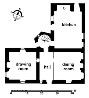
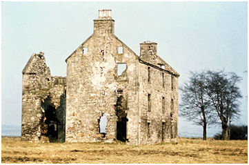
The kitchen in the north wing had an unusual number of doors. One was in the gable beside the fireplace, another in the west wall and a third into the stair tower from whence the rest of the house could be reached. The second of these doors was probably used to get water from the well which was located some 30ft WNW of the house. The kitchen fireplace measured 9ft by 4ft and possessed a segmental arch with heavily splayed margins. Fire-places were also set one in each gable on each floor except in the garret. Those in the principal rooms on the ground floor had moulded jambs and lintels. Grooves in the walls of the western ground-floor room indicated that this apartment was once panelled. On the upper floors the fireplaces were plain and simple.
The dormer pediment proclaims that the mansion was built for the family of Walter Rankine and Sarah Little and undoubtedly it was seen as the foundation of their new dynasty. Ironically their marriage was a seed which saw the family move to another estate. When her brother died their son, William Rankine, succeeded to the estate of Over Liberton in Midlothian and some houses and shops in Edinburgh. Thereupon he changed his name to William Rankine Little. Consequently William’s brother, Gabriel occupied Orchardhead until 1714 when William died and Gabriel too moved to Liberton.
In the 1720s Johnston of Kirkland owned the nearby property of Stonehouse and was often a visitor to the area. Part of his diary survives and there are two entries in 1723 referring to Orchardhead:
11 February. Monday. Went to Stonehouse met wt Mr Lindsay [the parish minister], stayed with him in Orchardhead, had sweet and suitable converse, saw some of the frolicks of the Lady pitied her had freedom in duty. Troubled with high mindedness.
6 April. Saturday. I went to Stonehouse from ych I went with Liberton [presumably Walter Little of Liberton] to Airth….
In his geographical description of the area, also written in 1723, Johnston noted that the parish “has a harbour south from Orchardhead called Greenbrae where ships of great burden come and get their loading of coals from the coalshore.” Indeed the mouth of the River Carron was an exceedingly busy area at this time. When the engineers came to survey the potential lines of the Forth and Clyde Canal in the 1760s they pointed out that there were already hundreds of shipping movements there every week. Another difficulty for the use of the river as part of the future navigable canal was the presence of salmon weirs, which presumably the owners of Orchardhead had interests in.
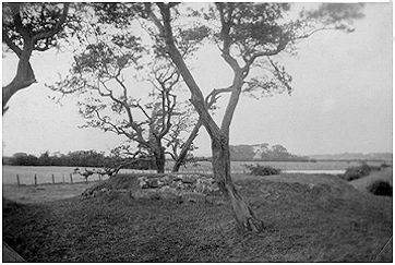
Illus 4: The Statue Base on the Sea Dyke, looking north-west, c1930.
The importance of the sea to the commerce of the area was recognised by the owners of Orchardhead by the construction of a raised platform of earth on the sea dyke at the point where the River Carron emerged. The square platform was edged about with dressed stone to provide a plinth for a large figure of Neptune. It was still there in the 1850s when it was mentioned by the Ordnance Surveyors
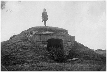
Illus 5: The Entrance to the Grotto looking WNW. Doreen Hunter, the future curator of Falkirk Museum, aloft. c1930.
100m ENE of Orchardhead House was a grotto (marked as a cave on the 1862 OS map) in the form of a mound of earth containing a vaulted stone structure said to have incorporated a relief carving and some lines from the Aeneid. It faced east across the estuary along the mouth of a small pow. The east face of the summerhouse was fronted with a stone wall containing a wide entrance with a low arch and topped with a projecting square eaves course with a rear flange to retain the earth cap. The RCAHMS refer to it as a summerhouse though it seems rather dark for such a use. It was demolished during the Second World War
The date of the monument to Neptune and the grotto are not known, but it seems probable that they belong to a time when the mouth of the Carron was still in this vicinity. It was redirected by the Dundas family in 1783.
Roy shows an embanked enclosure on this headland which would have been a suitable setting for the statue. The enclosure’s true purpose was to act as a bastion against coastal erosion and flooding.
Before long the “Libertons” spent almost all of their time in Midlothian and in 1787 Orchardhead was put up for sale:
“The house of Orchardhead, with the garden, orchard and inclosures around the house, containing about 20 acres, to be let or sold and entered to immediately… The lands hold of the Crown, and a qualification will be given to vote for a Member of Parliament. The House contains thirteen rooms, besides offices…”
(Edinburgh Evening Courant 5 May 1787).
There was no taker and the following year it was advertised again, with more land:
“To let or sell the house and inclosures of Orchardhead, pleasantly situated on the banks of the Forth, and within half a mile of Carron and the Great Canal. The house with the inclosure, garden and orchard, about twenty acres, mostly in grass may be entered to immediately; and if a purchaser incline, from 30 to 100 acres will be sold along with the house, and also a freehold qualification in the county. There is a good road to the house, good water, and several collieries near; which with a good market at Falkirk, and the vicinity to Carron and the Great Canal, in a rich plentiful country, makes the situation very desirable. The house contains 14 rooms besides offices.”
(Edinburgh Evening Courant 7 Feb 1788, 4c).
It was bought by John Ogilvie who in 1782 had acquired Charles Gascoigne’s sequestered estate of Gairdoch. He had a more local connection for in 1783 either he or his father was called John Ogilvie of Pocknave, factor for the Earl of Dunmore. He spent most of his time at Carron House on the Gairdoch estate where he witnessed the effect that the high price of meal or corn was having on the poorer people of the area. When he died in 1818 John Ogilvie of Gairdoch and Orchardhead left a sum of £1,000 to establish a trust disposition to be used in the purchase of meal in times of scarcity and high prices for re-sale at moderate prices to the labouring poor of the parishes of Airth and Bothkennar. The purchase and resale of the meal was to automatically kick in once the prices had reached a certain level. As it happened the prices never met the stipulated levels for the next half a century and in 1846 the repeal of the Corn Laws meant that prices remained low. The Ogilvie Meal Trust accumulated interest and by 1895 held just over £3,000. An appeal for a parliamentary bill to enlarge or alter the scope of the charity, to be known as the Ogilvie Meal Charity, allowed the money to be used for the poor of the area in other ways.
In 1813 John Ogilvie’s cousin, John Walker, was made heir apparent to the vast estates and stayed with him at Carron House. From that date on he was styled as John Walker Ogilvie of Orchardhead. His son, Charles Walker Ogilvie of Orchardhead, was also considerate to those less well off than himself. In 1867 his tenants in Bothkennar parish were suffering heavy losses due to a “cattle plague” and so to compensate them he greatly reduced their rents for the duration.
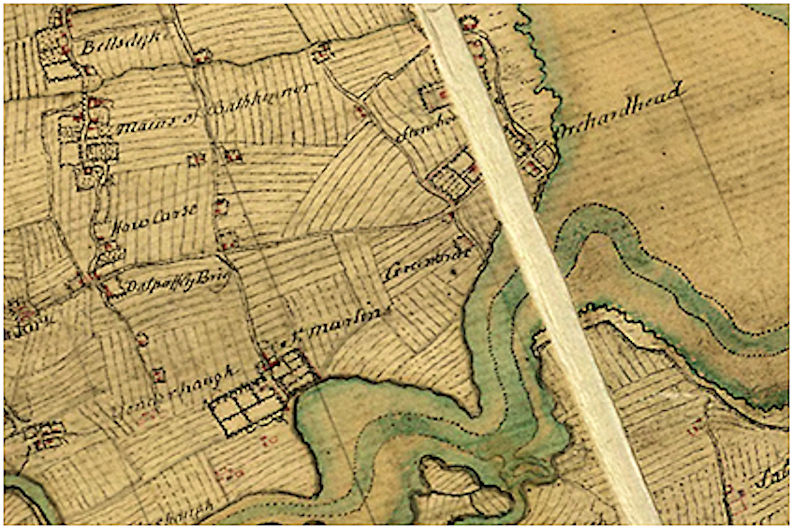
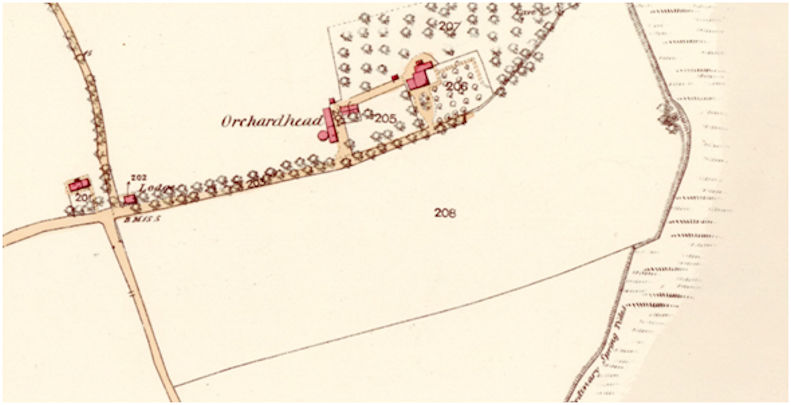
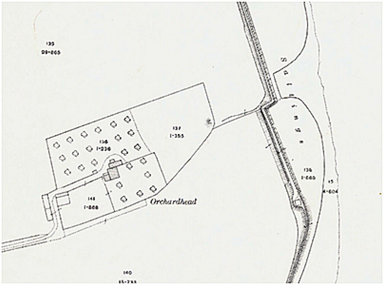
The first edition Ordnance Survey map provides a good idea of the layout of this small estate. At the point where Brackenlees Road turns through a right angle to head north a tree-lined access drive continued eastward to the house. Beside the main road was a small lodge which was probably built for John Ogilvie in the late 18th century. Set perpendicular to the drive, on its north side, was the small farmsteading or offices of Orchardhead. The round structure on its west side was a gin mill from the beginning of the 19th century. A service road connected the farmsteading to the main door of the house. The drive, however, continued straight on until it reached the house when it turned north to approach the house full on. Here a small forecourt contained a turning circle. As it approached the house there was a tall wall on the left for an enclosure associated with the farm; on the right was a formal garden with paths and fruit trees, also enclosed by tall walls to provide shelter against the chilling winds blowing across the Forth. To the north and north-east further shelter was provided by a wood and it was here that the grotto stood. The surrounding fields were flat and would have been farmed using a rotation of arable and pasture. The land was defended against the waters of the river and the estuary by a large sea dyke of earth constructed anew in the early 18th century and carefully maintained. On the other side of the dyke was a thin strip of sea green and then broad mudflats. The sails of ships would frequently be seen passing and some may have used the mudflats as temporary halting places, allowing the flat bottoms of the vessels to rest there between tides. Here too salmon fishers would have congregated at different times of the year.
The mansion seems to have become the farmhouse for the adjacent working farm which was tenanted by first the Mitchell family and then the Malcolms. The Ordnance Surveyors in the 1850s describe it as “A small farmsteading, dwelling house, three storeys, all slated and in good repair. Property of John Walker Esq.” The Malcolm family occupied the farm from around 1850 right up to the 1950s
| Forenames | Surname | Relation | Status | Age | Occupation | Where Born |
|---|---|---|---|---|---|---|
| William | MALCOLM | Head | married | 40 | Farmer (of 43 Acres) | Airth |
| Jane | MALCOLM | Wife | married | 30 | Polmont | |
| Jessie | MALCOLM | Daughter | 2 | Bothkennar | ||
| John | MALCOLM | Son | 1 | Bothkennar | ||
| Archibald | SCOTT | Servant | 21 | Agricultural Labourer | Tulliallan, Clackmannan | |
| Helen | BROWN | Servant | 16 | Domestic Servant | Bathgate | |
| Margaret | JACK | Servant | 16 | Domestic Servant | Polmont |
In 1856 an unsuccessful petition was put forward to extend the boundaries of the burgh of Grangemouth to encompass Orchardhead. The northern boundary was to be “From a point on the road at Poindfold Bridge, where the road to Orchardhead leaves the Kerse Turnpike Road, along the centre of the said road leading to Orchardhead, eastward to the crossing of he said road from Crofthead to Pocknave; thence in a straight line to Orchardhead Viewhouse on the embankment on the Firth of Forth; thence along the High Water-mark to the Bridge over the Grange Burn…” The Orchardhead Viewhouse was, of course, the Neptune monument.
Illus 8: Sketch of the Vignette on the 1852 Admiralty Map.
By then coalmining had been restarted in the area. The Zetland Pit was sunk in 1841 by the Grangemouth Colliery and was followed, around 1850, by Pit Number 4 known as the Palace Pit. It stood just yards to the north-west of the lodge at Orchardhead and continued in operation until 1911. A mineral line connected it to a jetty on the new course of the River Carron opposite to the Old Harbour at Grangemouth.
Some time before 1897 a single storey W/E building was added to the north side of the kitchen and may have been connected to the farming function. The old farm buildings which lay to the west of the enclosures were unroofed before 1915.
Orchardhead House gradually fell into disrepair and the 1947 OS map shows it too without a roof. Twenty years later the next map has “ruins” beside it. The empty shell survived into the early 1970s when it was demolished. Central Regional Council had been formed in 1975 and it purchased a large area of land in the area in order to promote its development as an industrial complex in extension of that at Grangemouth. There was even a proposal to build an airport here. The earlier coal mining meant that the ground conditions were unsuitable and these plans were dropped. Today the area is largely arable and there is no trace of Orchardhead House or its enclosures.
The list of owners and tenants (in burgundy) can be summarised as follows:
| Late 16th century | James Mure |
| c 1619 | Alexander Mure (son) |
| 1605 | Rankine of Orchardhead |
| 1670s | William Rankine |
| 1687 | Walter (James) Rankine (son) |
| c 1690 | William Rankine Little (son) |
| c 1701 | Gabriel Rankine Little (brother) |
| c 1737 | Walter Little (son) |
| 1790s | John Ogilive (purchase) |
| 1818 | John Walker Ogilvie (cousin) |
| 1860s | Charles Walker Ogilvie (son) |
| 1890s | Charles W Ogilvie (son) |
| Malcolm family (1840s-1920s) |
Sites & Monuments Records
| Orchardhead House | SMR 875 | NS 9229 8406 |
| Orchardhead Summerhouse | SMR 2183 | NS 9239 8411 |
| Greenbrae Harbour | SMR 1794 | NS 9164 8301 |
Bibliography
| Bailey, G.B. | 1992 | ‘Along and Across the River Carron: a history of communications on the lower reaches of the River Carron,’ Calatria 2, 49-85. |
| RCAHMS | 1963 | Stirlingshire: An inventory of the ancient monuments. |
| Porteous, R. | 1994 | Grangemouth’s Modern History, 2nd ed. |
| Reid, J. | 2009 | The Place Names of Falkirk and East Stirlingshire. |
G.B. Bailey (2020)
