The Antonine Wall, Scotland’s premier Roman monument, was built around 142 AD at the successful completion of a military campaign in southern Scotland that was undertaken by the Roman army on the orders of Antoninus Pius. He was probably motivated by a need for military prestige to strengthen his position as the new emperor of the Roman Empire. The Wall, like its predecessor built under the reign of Hadrian in 122 AD, would have been intended to divide the island in two. The area to the south was to be fully integrated into the Roman culture. However, following the death of Antoninus the Roman army withdrew from central Scotland c165 AD after an occupation of only a little over 20 years.
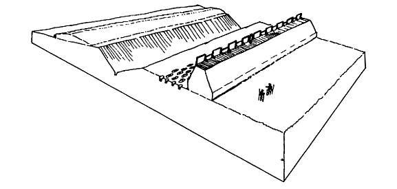
The Antonine Wall was a 39 mile (61 km) long barrier built across the narrowest part of central Scotland, from Carriden on the Forth to Old Kilpatrick on the Clyde. It consisting of a turf and earthen rampart standing 3.5 m (11 ft) high on a stone foundation and surmounted by a wooden palisade. Some 6 m (20 ft) to the north of this lay a massive V-shaped ditch, averaging 12 m (40 ft) wide and 4.2 m (14 ft) deep. Between the rampart and the ditch was a Roman minefield – small pits with sharpened wooden stakes protruding from them.
Attached to the south side of the rampart were a series of forts to provide accommodation for the garrison whose task it was to control movement across the frontier. At first there were only six of these, spaced at approximately 8-mile intervals, as had been the case on Hadrian’s Wall. The milecastles of that earlier wall were again replicated on the Antonine Wall, where they are known as fortlets, placed between the forts at intervals of around a mile. Between these would have been wooden watchtowers, probably set one third of a mile apart, just like the turrets on Hadrian’s Wall. The forts and fortlets were linked by a cobbled road known as the Military Way. This permitted men and supplies to move rapidly along the Wall. For some reason this original blue-print was changed part way through the Wall’s construction and the 17 forts we know today were built instead. Rough Castle, near Bonnybridge, is the best preserved of these forts. The others known to lie in the Falkirk district are at Carriden, Inveravon, Mumrills, Falkirk and Castlecary. At the same time that these extra forts were added the fortlets appear to have been abandoned, or replaced by a watchtower as happened at Kinneil.
Outside the forts lay small industrial zones where the army repaired its equipment and undertook small industrial process such as iron smelting and leather working. Before long these were enclosed by defensive ditches to form annexes to the forts. Outside these again were the military cemeteries, parade grounds, temples, cultivation plots and so on. We also know that civilian settlements composed of ‘camp followers’ were established nearby.
All of these structures, with the possible exception of the extramural villages, were built by the Roman army. Foremost amongst these were elements of the 2nd, 6th and 20th Legions.
Geoff Bailey (2005)
For further information see:
- Geoff B. Bailey “The Antonine Wall, Rome’s Northern Frontier” Falkirk Council Cultural Services, 2003
- Geoff B. Bailey, “The Antonine Wall in Falkirk District” pub. Falkirk Local History Society, 2021. ISBN 978-1-8382988-0-7
- To read some of the local lore from places nearby to the Antonine Wall, Click Here to read “Elves, Saints and Distilleries” by Geoff B. Bailey
