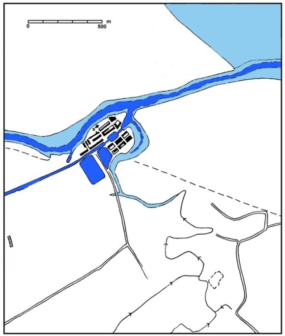
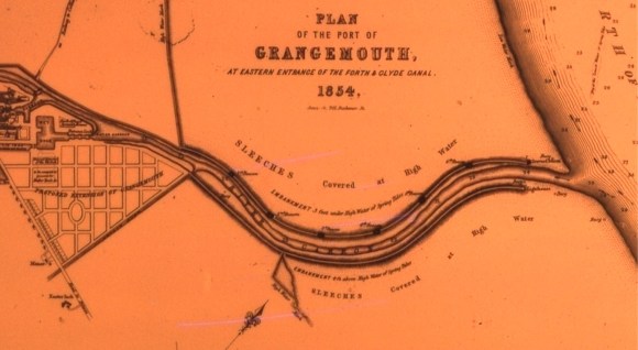
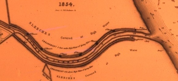
In the early 18th century, Carronshore was an important inland port and its busy trade was one of the reasons why the Carron Iron Works was sited just a little up river in 1759. The river could cope with vessels of between 60 and 120 tons and over the next half century the removal of several meanders increased this capacity to 200 tons (Bailey). The biggest obstacle to navigation remained the treacherous entrance to the river from the Forth with its twisting channels and shifting mud banks. The strong flow of the River Carron brought down a huge amount of silt from the upper valley and this was deposited in the sluggish waters along its lower reaches. At that time the waters debauched into the Forth near Orchardhead, which was located towards the northern end of a broad bay. Much of the suspended material issuing from the river was washed southward creating extensive sleeches in that bay. Agricultural improvements only exacerbated the problem, increasing run-off from the land.
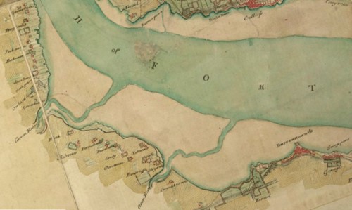
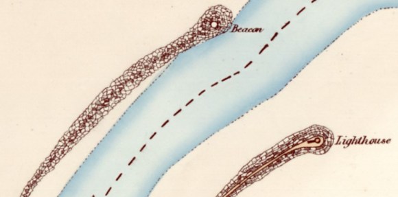
Ships entering the river mouth from the Forth followed a south-westerly course along a broad channel through the mudflats, lining up with Heuck Farm. About 400yds from the shore, at Holemerry, they had to turn more or less at right angles to the north-west and steered for Orchardhead House, the proprietor of which had conveniently placed a statue of Neptune on a little coastal temple appropriately known as the “Cave of the Winds,” as a further guide. Holemerry appears to mean “sea pool” (Reid 2010, 41) and is an ancient name. Approaching the temple there was another right-angled turn. The depth of water depended upon the state of the tide and it was all too easy to be stranded on a mud bank.
The construction of the Forth and Clyde Canal in the 1770s led to the development of a new port at Grangemouth. A tidal harbour was created outside the terminal lock of the canal at the junction of the Grange Burn and the River Carron. It was accessed by ships from Orchardhead by a broad loop in the river known as Greenbrae Reach which served as a sheltered anchorage. Vessels had to circumnavigate the Heuck peninsula to reach it. The placing of the canal entry at the mouth of the Grange Burn was a compromise between a proposal by the Carron Company to end the canal at Carronshore and a counter proposal to terminate it further east at Holemerry. The latter would have required a crossing of the Grange Burn, which would have been expensive, and the loss of the Greenbrae anchorage.
The removal of the large meander to the north of Grangemouth which contained Newton Reach and Daggedy Reach in 1781 by Sir Lawrence Dundas improved onward transit of vessels to Carronshore and created additional wharfage at the port, but it did not ease the approach to the embryonic seaport. The Forth and Clyde Canal Company had intended to make a tidal cut from the harbour through Heuck to Holemerry but its priority had to be pushing the canal further west towards Glasgow and the Clyde. So it was that in December 1782 a commentator noted
“the wretched state of the port, into which no ship can enter with safety”
(Caledonian Mercury 30 December 1782, 4).
This situation severely curtailed the growth of Grangemouth. The businessmen of Bo’ness, concerned about the potential of the fledgling port on the Carron, saw an opportunity and stepped into this lacuna with a proposal to extend the canal to the harbour at Bo’ness which was much more accessible from the Forth, particularly to the larger ships used on long distance routes.
Much investment had already been put into Grangemouth and the threat of a fully functioning Borrowstounness Canal spurred Thomas Dundas and the proprietors of the Forth and Clyde Canal to go ahead with the Holemerry Cut. Contractors were sought:
“Forth and Clyde Navigation. As it is proposed to begin, without delay, to make a NAVIGABLE CUT from Sealock through the Hewk Farm to Holmerrie; as also, to build an OUTER BASON at Sealock; — any person or persons that will undertake said works, or any part of them, are hereby desired to give in proposals and estimated for the same, to Nicol Baird surveyor of the Great Canal, at his house at Kelvinhead; which proposals and estimates must be delivered in before Thursday the 1st May next, as the Committee of Management will then take said proposals and estimates under their consideration.”
(Caledonian Mercury 23 April 1783, 1).
Things moved quickly:
“The new cut from Holmerie to this place [Sealock] is going on very fast, and will be navigable before Martinmas. The workmen, in cutting about the middle, found the bones and horns of two large deers, seven feet below the surface of the earth. The other improvements going on about Sea-Lock in building basons, harbours, quays, wharfs, crans, & c, surpass the most sanguine expectations, and which, taken together, will render it one of the most elegant, useful, and convenient undertakings this kingdom ever produced.”
(Caledonian Mercury 12 July 1783, 3).
The new facilities were promoted in a series of letters to the national newspapers;
“Since the favourable weather set in, the improvements and operations at the east end of the Canal go on with great spirit; and from the easy access which vessels of all burdens will have to the Sea-Lock, through the new communication at Holmerry, and the very excellent harbour and wharfs now completing for the accommodation of shipping, every possible facility and dispatch may be expected; and from this circumstance it may be reasonably hoped, that all heavy cargoes from the east sea, for the consumption of the west of Scotland, will continue to pass through the Canal the same as during the war, as the new improvements made upon this great and public spirited undertaking, effectually prevents those inconveniencies and delays which were frequently experienced in getting access to the harbour.”
(Caledonian Mercury 8 May 1784, 2).
It was a huge undertaking and it was to be 10 November 1783 before the first ship, a vessel of 100 tons, sailed outward through the new cut from Grangemouth to Holemerry. In 1811 Alexander Laird, one of the first businessmen to set up in Grangemouth, wrote that due to
“the straightening of the river Carron from the mouth of the harbour to Holemerry… the access to the harbour is made easy by cutting off a very intricate part of the navigation; and upwards of sixty acres of land have been gained within these two years, where was formerly the bed of the river. At Greenbrae, where ships of 300 to 500 tons burden were in use to discharge, because they drew too much water to get into the harbour, the ground is now under a crop of corn.”
(Graham 1812).
In reducing the distance by about a mile the Holemerry Cut increased the rate of water flow, helping to carry away more of the silt. However, this merely moved the silting problem further downstream and it was deposited directly amongst the sleeches at the river mouth. Once again plans were produced to further enhance the facilities and, as before, these had to be put on hold until trade had increased to a level which justified their execution and produced the income level necessary to pay for them. These plans included a proposed wet dock to the north-east of the existing harbour, entered from the River Carron at Holemerry. It was to be 1,500ft in length by 300ft in breadth, with 20ft of water in the gates at spring tides; the gates to be 40ft wide. This dock would thus contain 100 square rigged vessels with ease. It was intended to communicate with the existing harbour by a 10ft deep canal, 40ft broad at bottom and 60ft at the top. The entrance to the wet dock, being further down the River Carron, would be nearer the deeper water. The whole expense of this undertaking was estimated in about 1805 at around £30,000; but, from the increased price of labour and of materials this rose to over £40,000 in 1812 (Graham 1812).
Still nothing happened. In the meantime the infrastructure at Grangemouth was enhanced. This ranged from additional warehouses and wharves, extended timber basins, a customs house, a dry dock, shipyards, and rope works, to the bringing in of long-distance turnpike roads. All the while trade slowly increased.
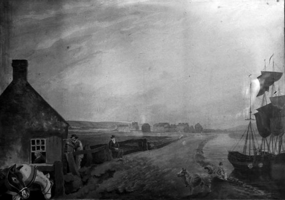
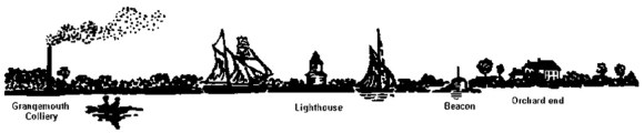
The man beside the house looks through a telescope pointing out to sea. The window of the house has the shutter open and a woman looks through it, noting the time of arrival of each vessel. A man sits on a sturdy wooden bench on a sluice for the new Grange Burn. Along the south embankment of the river was a road which could be used for tracking the boats and in the foreground two ponies wait in readiness. The two small vessels would have taken the pilots out to the large ships upon their arrival off the river entrance.
Minor alterations were made to the mouth of the river. A series of navigation beacons were erected along its course through the mudflats. These must have taken the form of massive wooden poles surmounted by a wrought iron basket. During daylight the poles were visible and at night pitch torches would have been lit in the baskets, a boatman being paid to perform this duty. The distance from the quay at Grangemouth to the outmost beacon was reckoned to be about a mile and a half. Vessels entering the canal were conducted up the Carron by pilots, 15 or so in number, who held license of pilotage from the Trinity House of Leith. By 1840 they had been superseded by the employment of small steam-boats, which towed the vessels from the river mouth, thus rendering them less dependent upon tide and wind. At that date two steamboats were in that service (New Statistical Account). Even so, there were many strandings and not a few accidents.
It was to be the late 1830s before the development of the port access was taken in hand. The situation was neatly summed up by the parish minister in 1841:
“The want of accommodation at the port has been long complained of. Proposals and plans of enlargement were made many years ago, when the canal did not yield a fifth of its present revenue. In 1838, effective measures were adopted. The late Earl of Zetland and the Forth and Clyde Canal Committee employed Mr Macneill, civil engineer in London, to take surveys, and to submit a report of improvements. The report embraces the following particulars, 1. The changing of the direction of the Grange Burn. 2. The formation of a wet dock on the south-east of the present harbour, 27 feet in depth, and of such dimensions as to contain forty sail of the largest class of steam and merchant vessels. The sea lock, to shut the dock, is proposed to be 300 feet long and 70 broad. The formation at Bristol of a lock a few feet larger, deprives this one of the boast of being the largest in the world, and leaves it only the second place. 3. The deepening of the River Carron, so as to allow canal traders drawing nine feet of water to arrive and depart at low tide. 4. An enlargement of the easter timber basin, and a junction betwixt it and the wet dock by means of a canal ten feet deep.”
(New Statistical Account).
Macneill’s report was adopted, and the minister went on to note that
“from April 1838, 200 artificers and labourers have been employed in working it out. Above twenty acres of land have been allotted for these improvements; and, by 1843, they are expected to be in such a state of forwardness as to admit vessels into the wet dock.”
The whole project was overseen by Thomas Wilson, the supervisor for the eastern half of the Forth and Clyde Canal. Wilson was a very capable engineer and had been responsible for the construction of the world’s first iron vessel, the Vulcan. The entrance to the wet dock from the River Carron was to be 460yds further east than that of the old harbour. Details of its construction can be found in a daily log kept by Wilson.
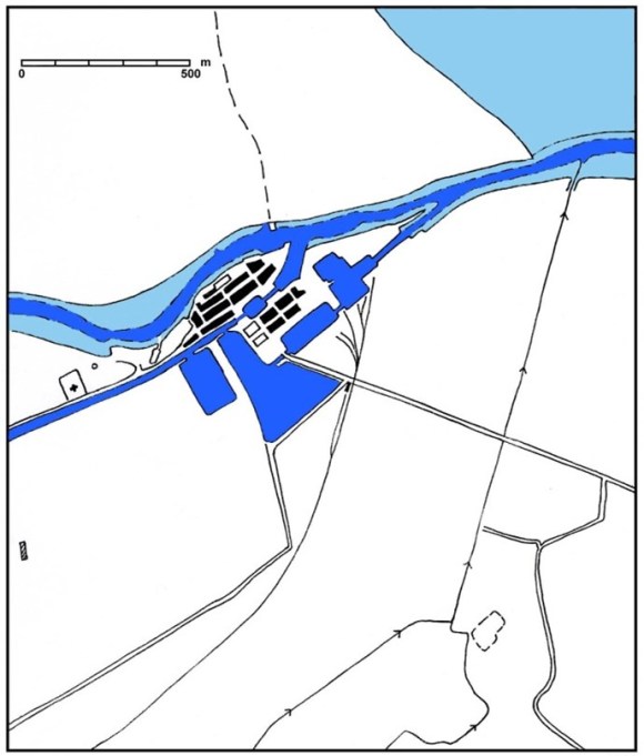
One of the first tasks in the Grangemouth Improvement Scheme was to divert the course of the Grange Burn which until then entered the harbour. A long straight channel was dug to take it well to the east. The old channel was then filled in, beginning with a dam at the harbour end. The harbour was reconfigured and a new wharf constructed on the seaward side of this dam. Nearby, a temporary lighthouse was erected to help ships to negotiate the new layout:
“Friday 29th March 1839
Carpenters in preparing a platform for the lighthouse proposed to be erected south of the Main Crane on the Stone Wharf. Mr. Black measuring.”
(Wilson’s Log).
At the same time as the wet dock was being constructed work began on improving the course of the River Carron across the mudflats. Deepening of the Carron began in March 1838 (Perthshire Advertiser 29 March 1838, 4). The river was to be made straighter and contained between embankments, and its central channel was to be dredged. This was not to be an easy task and the design of the embankments or moles which were to jut out into the Forth for over a mile seems to have relied upon empirical observations. As they were to be formed from earth dug out of the wet dock they were to have a wide base and a low profile to conform to the angle of rest of the material. On 3 December 1838 Alexander Black was employed in making surveys of the area, much of which was covered at high tide. As a temporary measure an old barge was acquired so that she could be sunk adjacent to the existing outer beacon at the mouth of the river in order to make that marker more visible. On 27 August 1839 the Log entry reads:
“We lifted the Grangemouth Lighter belonging to Mr Joseph Bog and took her out to Carron River entrance and placed it on the West side of the Beacon and put a few Punt loads from Dredging Boat on board but the stuff was no sooner put on board than the vessel rent asunder and the upper works separate from the bottom so that the vessel will not answer to the purpose intended – that of making the Beacon more conspicuous at Night.”
(Wilson’s Log).
The lines of the proposed embankments were subsequently staked out. At first the earth dug out of the new dock was simply dumped between the stakes. This was a laborious task and between 300 and 400 labourers and artificers were employed, most of whom were Irish under the charge of Feely & Sons. A temporary railway was constructed to help with the transfer of the material to the south embankment but on 9 January 1843 some 50yds of the embankment slipped into the river and required the insertion of piles. From then onwards the lines of the new sections of the embankments were positioned further back from the river channel. The consulting engineer visited:
Thursday 19th January 1843
Messrs McNeill, Thomson & Black returned today and went down to the embankment. Mr McNeill requested that we should take no more of the bottom from the two Beacons to being afraid that the current will underminded the embankment and promised to write out a memorandum of what he considers necessary to be done on both sides of the River. The following agreement was made with Peter Feely for conveying the stuff beyond the Pansteed Green, to be paid at the rate of ten shilling per lineal yard of embankment. Measuring from the short cross embankment at Pansteen green out to the point at which the embankment was formed on the 3rd November 1842 and to be paid from that date at the rate of two pence per cubic yard upon the total quantity at that time to be removed from the Dock, and also from the entrance from the river to the lock. The measurement to be ascertained by Alexr Black. The quantity at the above date in the Dock being about 18,500 yards.
(Wilson’s Log).
On 7 February 1843 Macneill recommended that the embankment on the north side of Carron River should be commenced and that the beaching (stone rubble facing) on the south side should be carried down to the level of low water to prevent the current undermining the facing of the embankment. Alexander Black fixed stakes for the North embankment and work immediately began on it. There was then something of a hiatus when problems with the excavation of the wet dock demanded the presence of the workforce there. By April the south embankment was nearing the outer beacon and Wilson
“gave orders to G. Colvin to place the stones on the west side at outer Beacon more compact so as to prevent the rush of the tide from cracking a passage west of the beacon. Was sorry to observe the slope next the river at the extremity inclining to slip in.”
The squad working on the embankments were under the management of George Colvin of Grangemouth. The next day
“In consequence of the slope next the river at the extremity of the embankment still inclining to slip wrote to Mr Johnston recommending to drive piles at the fit [foot] of the slope with view to prevent it slipping bodiely with the river.”
(Wilson’s Log, 11 April 1843).
The angle of the slopes was also reduced to two to one (i.e. 26 degrees), requiring a wing wall outside the dock gates.
The problem was only slowly overcome:
“17April 1843
“Went down to the River Embankment this morning and was sorry to observe the slope next River have again given way. This is the third time and I am much afraid that we will be under the necessity to commence and drive Piles half way up the slope for about 90 or 100 yards, but as it may have a chance to stand in its present position for some time, and as the tides are now falling off, I am sorry to throw Peter Feely’s men & horse idle until the Piles are drove. I have ordered Geo Colvin to alter the South Rail to be shifted further east and make a treat for a day or two, and if it then found that the Bank is still inclined to give way, that we will then commence to the Piling.”
(Wilson’s Log).
By the end of June the south embankment was abreast of the third Beacon. Punts were now used to take some of the earth to the far ends to be discharged into the heart of the embankments. This included soil removed by the dredger and had to be taken out of the vessels by hand.
“When this stuff is not required to form part of the Embankment each Punt discharged at the rate of one shilling & four pence & when required to form part of the present Embankment each punt load discharged at the rate of two shillings and sixpence on condition that he is to be furnished with wheeling plank & Barrows. The punts not to contain more than 16 or 18 tons of stuff on average. The rate of out put not to be less than one hundred & fifty punts weekly on an average.”
(Wilson’s Log 12 August 1843).
As the embankments grew in length they became more vulnerable to the creation of erosion channels by cross currents, creating gaps in their lines. This was particularly common on the north bank of the river and in an attempt to avoid their formation, a ditch was dug along the north side in advance of the erection of the earth dyke. It was counter-productive – not only did it fail to stop the creation of the channels or “gullets” but it also destabilised the mounds. Once such a cross-channel started to be formed it was a race to get it plugged before it became well established. By trial and error it was found that the best way of countering the gullets was to fill them in with dumps of clay as soon as they appeared. Access to the advancing end of the north embankment was facilitated by the use of a yawl to transport the workmen to it.
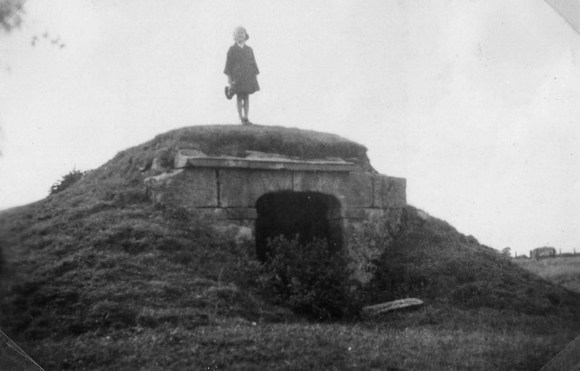
The evolving nature of the design is exemplified by the decision in September 1843 to add beacons to the north embankment. There were essentially well-constructed stone cairns which protruded above the high water. At the same time it was agreed to anchor buoys to the east of the lock entrance as further guidance to the ships. These were made of yellow pine logs. The following month modifications were made to the outer beacon:
27 October 1843 – Men went out to entrance of the River and placed the Two Casks on a spar and Bolted to the Oak log placed on the Outer Beacon, which I trust will have the effect of leading the vessels during the night to enter the River in safety. The Buoy opposite which brock adrift was also placed after Boring a hole into the stone and to fasten the Ring Bolt, and another Buoy placed further east.
(Wilson’s Log).
On 23 October 1843 a report assessed the costs of the work still to be completed and this included:
| “River Embankment To 150 yards to extend the East Embankment at 80 L | 600 | |
| To 7999 yards required the Bank having subsided on an average 3 feet at 1/2 | 408 | 6 8 |
| To 2700 tons stones to raise the embankment 3 feet & workmanship at 2/ | 270 | |
| To 480 Tons Road metal for the above 2/6 | 60 | |
| To 1500 lineal yards for the West Embankment at 40/ | 3000 | |
| To 6 Beacons, £10 | 60 | |
| To 10,000 yards to be removed from lock entrance at 6 | 250 | |
| To 3 Buoys & chains to be placed in the river at 100/ | 15 | |
| To 2360 yards pitching east from the lock at 2/ | 236 | |
| To one Anchor buoy & chain to be placed in the river east of the lock | 10 | “ |
Towards the end of 1843 the south embankment was nearing completion and it was decided to place a navigation beacon on its terminal. The form of the beacon had evidently not been fixed and so on Monday 13 Nov 1843 Wilson made an entry into his log:
“Messrs Crichton & Thomson were here today, went to the end of the South embankment. Mr Crichton agreed that the extreme end should be made a little, say 20 feet, wide at the top to have space for a Light house.”
A month later he was still discussing the requirements of the site:
“Wednesday 13 December 1843 – Went down to the extremity of the Embankment. That part described by Mr Thomson will require a very great quantity of stone to form the Circle and the breadth required for a Signal or light house which will be of great use when the Embankment is finished.”
A signal mast was erected on this exposed site and it was not long before it suffered damage:
“Saturday 9th March 1844 – We have had most severe Gales of wind this Forenoon upon the S. West, which made a complete passage over the embankment and has Blown down the Signal mast on the Outer Beacon”
(Wilson’s Log).


The Stirling Observer of 8 August 1844 noted the intention to replace it. The embankment, it stated, terminated in:
“an outer breastwork sufficient to allow a carriage and four to make easy and safe revolution. Here is also intended to erect a light-house, the true value of which can be appreciated only by the mariner.”
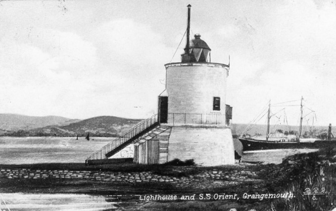
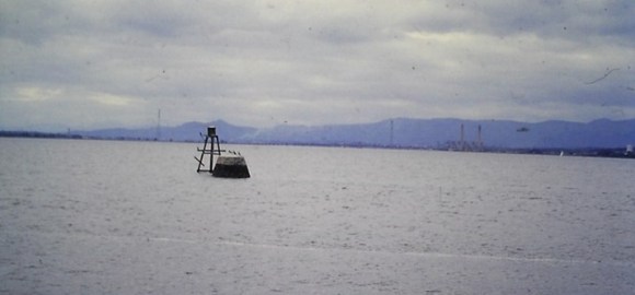
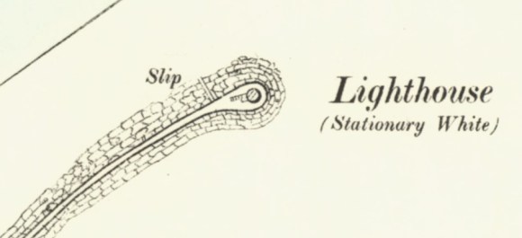
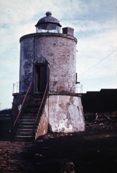
Work continued on the northern embankment of the River Carron but, being of less importance. it was carried on gradually and at no great expense (Glasgow Chronicle 14 May 1845, 2). It was studded with the stone beacons. Three of these were more substantially constructed than the others, with tapering drum-shaped structures. These three included the seaward beacon which sat on the bulbous terminal. The lighthouse that was erected at “the point of the bank” at the end of the south embankment was inaugurated on 11 August 1847. It was a substantial structure, circular in plan it had a tapering lower storey 5.46m in diameter at the base, made out of hard sandstone rubble covered with a protective layer of roughcast. This was topped with a plain stringcourse which carried an iron-railed walkway, bounded on the inner side by a tall brick upper storey about 4.78m in diameter. The door to the upper room was reached from the west by a narrow flight of stairs supported on flanking brick piers. The door margins were of dressed sandstone, as were the margins of a small window on the sheltered south side. A parapet ran along the wallhead was capped by an eaves-course. This sheltered a walkway round the central glass chamber which contained the fixed white light which was placed 32ft above the high water mark. The walls of the chamber contained eight panes of plate glass under a metal-clad dome. It was lighted by six superior Argand lamps, properly trimmed with sperm oil. The emitted light was strengthened by finely polished metallic reflectors.
“During the night it showed a steady brilliant light, and was seen distinctly by ships after they had passed the ferries on the inward passage, and also from every point of an extensive circumference”
(Stirling Observer 26 August 1847, 1).
The embankments had been completed and the Stirling Observer was impressed:
“At immense labour, we may also state, an embankment has been carried out to the mouth of the Carron, a distance of nearly three miles from the port. At the base the embankment is nearly 60ft wide, which is reduced by an angle on both sides to 12ft at the top, forming an extended place… The strength, regularity, and beauty of the Carron embankments are admired by numerous parties who sally out to enjoy the refreshing sea breeze.”
(Stirling Observer 8 August 1844, 4).
In 1866 the Commissioners of Lighthouses in Scotland reported that the light was not provided with any optical apparatus for saving the light. From its important position on the Firth the Commissioners recommended that a new lantern and proper dioptric apparatus should be substituted (Falkirk Herald 8 March 1866, 7). A slip was also inserted into the inner side of the embankment a little to the west of the lighthouse to allow small boats to land and to aid the work of the rescue boats. Despite the presence of the lighthouse it is amazing just how many ships grounded on this stretch of the coast. The embankments acted as breakwaters countering the effects of winds and side currents and creating a safe channel.
Even before their completion the embankments were used to help with the reclamation of land from the Forth. The Earl of Zetland started the process on the north side of the river in 1840 and more and more were subsequently added. In 1875 Thomas Livingstone Learmonth submitted a parliamentary bill to embank and reclaim thousands of acres of land from the Firth of Forth’s waste or slob lands, which were wholly or partially subject to be overflowed by the tide, and which lands were to be reclaimed and enclosed by means of the embankments or sea walls which were to butt up against the Carron embankments.
The deepening of the Carron, which was sometimes now referred to as a canal, provided a depth of 20ft of water. Silt from the dredging operations was dumped in the old river channel off Orchardhead. However, the new course was still prone to silting and in 1855 there was not a sufficient depth to allow the largest class of vessels which traded regularly to Grangemouth to reach the port at neap tides, the steamers belonging to the Carron Company having frequently to wait in the Forth for the advance of the tide before they could bring in their cargo. Vigorous dredging of the channel was not able to keep up with the problem and eventually it was admitted that the only way to solve the problem was by extending the dock system further out towards the mouth of the river. That massive engineering project will be looked at in a future paper.
The flat top of the south embankment made a spectacular walk on sunny days with views up and down the estuary and it became very popular. In 1878 the chief magistrate of the burgh mentioned the need to improve this promenade. It was 1890 before the new provost, Hugh Macpherson, gifted three ornate cast iron seats from the Grange Iron Company which were placed on the path. The walk was not, however, a right-of-way, and its use was only permitted by the Caledonian Railway Company, which had taken over from the Forth and Clyde Canal Company, at its discretion. Over the decades the outlook from the embankment changed dramatically. The mudflats to the south and east were utilised for the construction of the new wet docks which were built on an even more massive scale. The once isolated light house found itself closer and closer to this activity. The lighthouse was still manned in 1878 and the lighthouse keeper, Alexander Ames and his wife, Helen Balfour, lived on its first floor. The address was given as “lighthouse, Grangemouth Road, Polmont” – as it was in the parish of Polmont and fully two miles from Grangemouth. At that time there was a large number of navvies working on the dock extension. One day in December Alexander went into town to get provisions and whilst he was away his wife was brutally assaulted by Hugh McHugh, one of the gaffers on the works. McHugh was later sentenced to 18 months imprisonment.
The lighthouse does not appear in the 1881 census and so its use as a residence may have been discontinued at that time. It was still manned, and when, in May 1888, a pilot named William Collins returned late at night from Bo’ness in a small boat during a gale he was observed from the lighthouse endeavouring to make his way into the River Carron. It was at that point that the boat disappeared and it was found washed ashore at Limekilns, near Charlestown, the following day. Collins was not heard of again (Dunfermline Saturday Press 5 May 1888, 3).
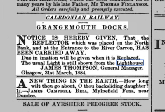
About six o’clock on the morning of 31 March 1884 the steamer Derwent, of and for Grangemouth, from London, ran ashore on the south side of the north embankment at the entrance to the river Carron. She was got off that night without having sustained any damage, but the reflector in connection with the lighthouse was completely demolished, and notice was made by the harbourmaster warning mariners (Falkirk Herald 2 April 1884, 3). The reflector seems to have been located on the seaward beacon opposite the lighthouse and was soon put back in order.
It was around this time that the lighthouse was referred to as a beacon lighthouse or light beacon. It was still maintained:
“Caledonian Railway. Notice to mariners. GRANGEMOUTH HARBOUR. LIGHT AT ENTRANCE TO RIVER CARRON. The Caledonian Railway Company hereby give notice that owing to an Alteration to be made on the present Light at the Entrance to the RIVER CARRON, a TEMPORARY LIGHT of less power, but of the same character as the present Light, will be shown from the Lighthouse on and alter the Evening of 5th SEPTEMBER Next, and until further notice.
Due notice will be given of the further Alterations at the Light…”
(Falkirk Herald 27 August 1890, 1).
The end of the north embankment was again damaged in October 1897:
“Caledonian Railway Company. GRANGEMOUTH HARBOUR. NOTICE TO MASTERS OF VESSELS, PILOTS, AND OTHERS. THE BEACON carrying the REFLECTOR opposite the Lighthouse at the ENTRANCE to the RIVER CARRON has been Destroyed, and the Apparent Light will not be Visible until the Beacon and Reflector have been again erected…”
(Falkirk Herald 30 October 1897, 1).
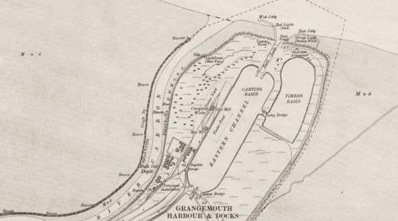
With the massive development of the new docks by the Caledonian Railway Company a new dock entrance was placed to the north-east of the old lighthouse.
This required the positioning of fixed lights on the jetties to either side of the new entrance – a constant red light on the West jetty and a flashing white light on the East Jetty. The old lighthouse continued to be illuminated and duties relating to the lights now fell on the railway workers. The gatemen demanded the annual allocation of uniforms in return for undertaking this additional work, but those not being forthcoming they discontinued the performance of all duties relating to the lighthouse (Falkirk Herald 3 December 1913, 3). The south embankment now became the new shoreline.
The lighthouse seems to have continued in use until the Second World War and still had its roof in 1953. It then fell into decay. A photograph of the late 1960s shows it roofless but still surviving up to the wallhead.
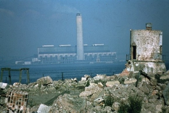
By 1999, when the author visited the building, it had developed a lean and a massive crack had opened up on its south side. Today the walls are greatly denuded.
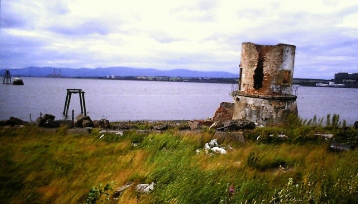
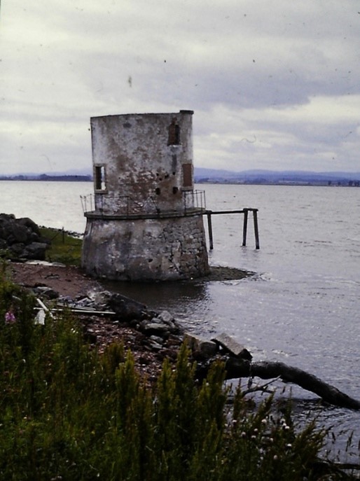

Illus 17: Three Photographs of the Lighthouse in 1999.
Sites and Monuments Record
| Carron Lighthouse | SMR 1147 | NS 94545 83831 |
Bibliography
| Bailey, G.B. | 1992 | Along and Across the River Carron: a history of communications on the lower reaches of the River Carron,’ Calatria 2, 49-85. |
| Graham, J. | 1812 | General view of the Agriculture of Stirlingshire. |
| Wilson’s Log | Falkirk Museum |
