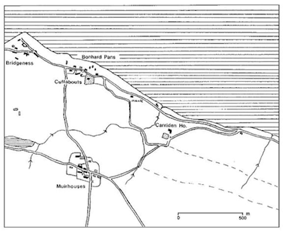
Carriden House stands on the 100ft contour at the top of an escarpment overlooking the southern shore of the Forth Estuary 2.7km east of the town centre of Bo’ness. Its vast estate stretched up the hill to 300ft above sea level and was bounded on the west by the estate of Grange, latterly delineated by the A904 Carriden Brae, and on the east by the lands of Burnshot. To the south was Bonhard House, which will be the subject of another study. An inland loch to the west of Muirhouses fed the Carriden Burn which flowed in an easterly direction into a deep and picturesque glen full of waterfalls. It was met by the Muirhouses Burn just to the north-west of the old stable complex and then headed northerly to the coast at Burnfoot where there is a sandy beach. The soil on the estate is generally light and easily worked, capable of producing good crops.
Carriden has changed hands many times. The known owners of Carriden are summarised here:
| Sir William de Veteriponte | |
| Sir Alexander de Cockburn – Sir James Cockburn | 1358-1541 |
| Patrick Abercromby – Patrick jnr | 1541-1601 |
| Sir John Hamilton – John jnr | 1601-1667 |
| Sir Walter Seton | 1667-1678 |
| Walter Cornwall | 1678 |
| Alexander Milne | 1679-1696 |
| Colonel John Erskine | 1696-1702 |
| General George Ramsay (Dalhousie) & heirs | 1702-1719 |
| Colonel Francis Charteris & heirs | 1719-1764 |
| Colonel Campbell Dalrymple | 1764-1767 |
| William Maxwell – Wm jnr | 1767-1811 |
| Admiral Sir George Johnston Hope | 1812-1818 |
| Lady Georgina Hope | 1818-1829 |
| James Hope | 1829-1881 |
| Mrs Hope | 1881- |
| Helen Hope | -1890 |
| Col. George Lloyd Verney | 1890-1896 |
| James Lloyd Verney | 1896-1909 |
| Harry Lloyd Verney | 1909-1912 |
| Joseph Constant (London) | 1912-1916 |
| Bridgeness Coal Co | 1916-1923 |
| John Paul | 1923-1977 |
| Tom & Anne Barkhouse | 1977-1996 |
| Graham & Barbara Blackbourne | 1996-2017 |
| Michelle & Ross Chian | 2016 – |
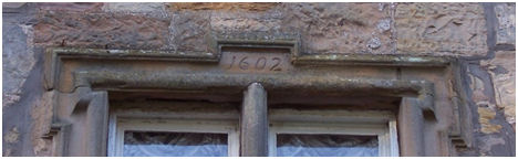
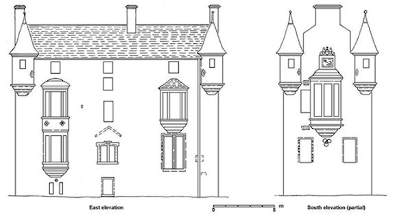
The earliest datestone on the present-day mansion at Carriden is 1602, but it is evident from the context that this was inserted into the fabric of an even older building. Changes in wall thickness and the presence of butt joins show that the earliest surviving structure at Carriden House is that of a tower house with two vaulted rooms at basement level. This building measured 10.3m N/S by 7.3m W/E, with walls up to 1.1m thick. The axis of the vaults ran W/E and that in the southern room still survives.
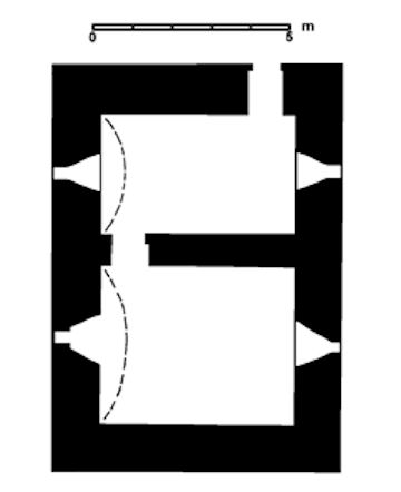
A splayed window at either end of the southern vault reflects the original arrangement, though now considerably widened with the western one blocked. The arrangement in the northern vault would have been similar. The entrance to this basement level was by a doorway in the north-east corner. This is now blocked, but the outside face with its rounded margins can be seen in the later wine cellar (the interior face has a fireplace inserted into it in the present boiler room).
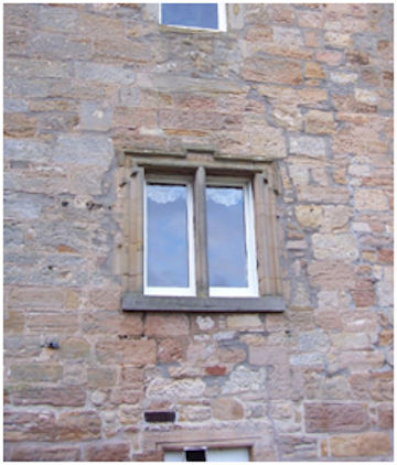
The walls were made of coursed masonry composed of large blocks of local sandstone, which is yellowish or pink in colour, bedded with a high ferrous content. This is of moderate hardness. The quoins were of harder, greyer, sandstone, carefully chosen for the purpose. Bedrock lies close to the surface at this point and provided a solid foundation.
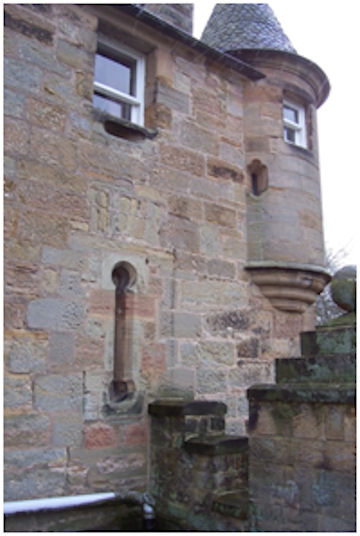
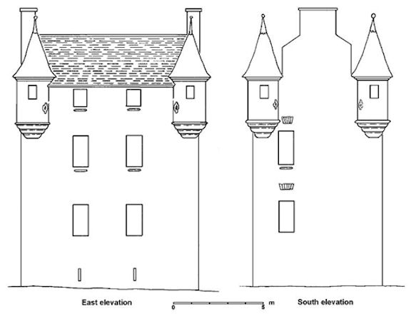
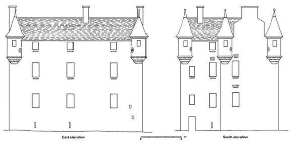
The arrangement of the upper storeys is less certain. The tower house was as tall as the later building, as is shown by the way that its north-east corner was keyed into the next extension, and the presence of the probable remains of the entrance to a corbelled turret on the north-west corner. We can also assume that each corner was capped with a similar turret. In between these the cavetto eaves course would suit the early date. Immediately below this, on both the west and east faces, are small square windows with rounded margins similar to those on the ground floor doorway. Each has a horizontal oval gun loop incorporated into the sill. Directly below those on the west face are similar rectangular windows, also with sill gun loops (the southern window now replaced by a blind vertical ornamental loop). These windows have flat relieving arches made up of narrow sandstone slabs, placed one course above their lintels. Two similar blocked windows can be seen in the south face, towards its western side. The lower one has holes in the margins for a wrought iron security grill. The fenestration on the east front has been almost completely removed by the 19th century alterations – so here we must postulate a vertical line of small window openings in line with these later ones. The ground floor openings for the vaults would have been little more than arrow slots. The main door may have been at first-floor level, with no real internal access to the basement. Presumably a small spiral staircase in the north-west corner provided access to the upper floors.
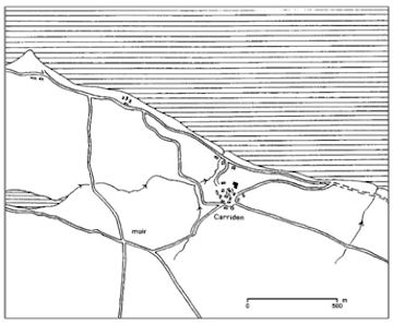
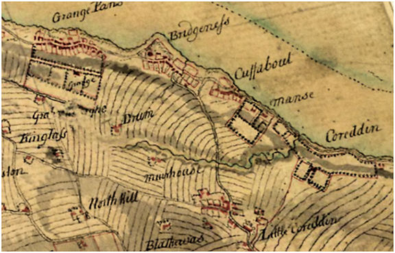
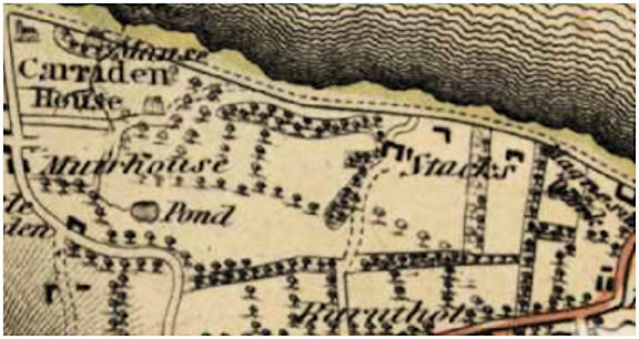
The profuse use of horizontal gun loops suggests a date in the mid 16th century for the tower house. Pont’s map of the 1580s shows a tower house, but unfortunately this part of his map was drawn early on in his work and the symbol is rather vague and unreliable in detail. At this time the parish church and churchyard immediately to its south-west were still in use. On the other sides of the burial ground was the village, with the main street passing from Bo’ness in the west to Blackness in the east. The houses were poorly constructed; the walls were of earth and turf with stone reinforcing and only a minimum of timber in their fames. A spur road ran north-west from the village and descended into the Carriden Glen to the shore where there was a sheltered bay suitable for shipping. South of the village there was a swamp and the small intensively cultivated fields of the infield lay to the east.
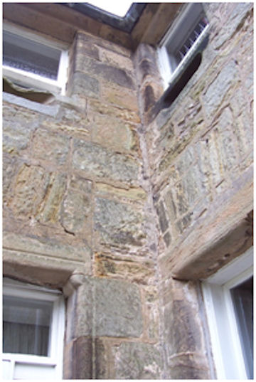
After a relatively short interval a north wing was added to the tower house forming a typical L-shaped house of the period. Stylistically it was the same as its immediate predecessor. The use of flat relieving arches in the same form as before indicates that it must have been completed within a decade or two of the tower. It was here that, around 1850, some workmen found a piece of lead “fastened in the wall bearing date 1604” (OSNB). The quoinstones at the north-east corner were removed and the east wall was extended northwards. The south wall of the new jamb butted against the west wall of the tower. The floor levels were the same and the fenestration echoed that of the tower, with horizontal gun loops below the sills.
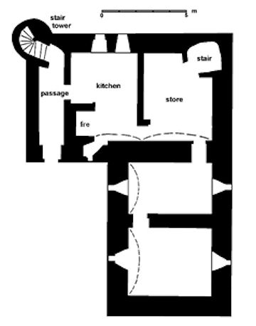
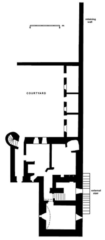
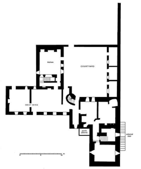
The main entrance was now on the ground floor at the west end of the south façade (removed by later modifications) and led into a N/S passage. A door on the right of this passage opened into the new kitchen. It, like the storeroom to its east and the passageway, had N/S aligned vaults. In the north-east corner of the storeroom a spiral stair led up to the hall above, but no further. The main stairwell was set in a protruding tower on the north-west corner of the jamb at the end of the passageway. The large kitchen fireplace backed onto the passage, helping to heat it. This layout continued on each floor, with the hall fireplace on the first floor also built into this wall. It is an odd arrangement as the passageways only served a limited number of rooms. The hall occupied the whole of the first floor of the jamb, with two large windows looking across the Forth and one in the east wall looking across the gardens. Access to the rooms on this level in the tower house must have been through the hall. Bedrooms and private chambers were provided on the second floor.
The rather poor layout was greatly enhanced by modifications carried out in 1602 by the insertion of a central staircase which served the rooms far more effectively. The main entrance was now placed in the centre of the east façade at first-floor level and was reached by flights of steps running along the outside wall. The main door was embellished with a roll and hollow moulded surround. It was shouldered and the upper member rises and returns around the date 1602. Above it the inverted V-shaped raggle of a wooden porch can be made out. This door led to a new entrance hall or lobby with a new floor. The vault of the basement room was removed and a large masonry pier was inserted to support the new staircase. A straight flight of steps on the left led down to the basement and that on the right up to the next floor where it became a wide spiral staircase. At the point of change-over a doorway with chamfered margins occurred (and can now be seen in a cupboard).
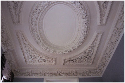
Turning left from the main door would have brought the visitor through a newly inserted roll-moulded doorway surmounted by a moulded entablature into a fine room with a new plastered ceiling, now known as the study. Tradition has it that this was executed by Italian craftsmen who had been working at Holyrood. It has a deeply undercut fruit and floral wreath forming a central oval with foliate designs in the spandrels, and swagged coving above the cornice. This room had windows on the south, west and east sides, and a second window was added on the south. Both south windows were given roll edge margins. Turning right from the main door now led into the hall. The large east window of the hall had unusual splayed margins to improve its lighting function and was also provided with security bars. It may have been at this time that a mullioned window was inserted into the second floor on the north side and provided with the usual gun loop.
Sir John Hamilton of Letterick, who later became the first Lord Bargany, had acquired Carriden estate in 1601 and these major alterations can be attributed to him. Carriden was conveyed to his son of the same name in 1632. The grounds must have been laid out anew as part of this reconfiguration. A broad bank of earth was placed along the eastern side of the house, extending south to the east side of the churchyard. This created a lower terrace to the east for the formal gardens. It was probably over the following decades that the start was made to the ha-ha that separated the gardens on the east from the fields beyond, allowing the view towards Blackness Castle and the House of Binns to be enjoyed to the full. Terraces would also have been created to the north with a small courtyard and outhouses adjacent to the house. A 10m deep well lay in the centre of this courtyard, cut into the bedrock.
Throughout the 17th century the size of the population in the village at Carriden decreased as families moved to the growing port at Bo’ness, or to the shore at Bonhardpans. Carriden on its hill, which had been secure in an age of violence, was inconvenient as a place of seaborne business during the growing peace and prosperity. Latterly this movement of people was promoted by the owners of Carriden House in the hope of increasing their privacy and improving the grounds. The small hamlet at Muirhouses took some of those whose work was on the land. The adjacent muir would have been common grazing ground until divided into feus.
In 1667 Carriden passed to Sir Walter Seton and shortly after, in 1678, to Walter Cornwall. They were both neighbours – Seton also holding Abercorn and Northbank, Cornwall having Bonhard. Having substantial houses nearby neither took a particular interest in Carriden House. Indeed, Cornwall only held it for a year and then disposed of it to Alexander Milne, a past provost of Linlithgow. The Milne family included prominent architects and masons who had worked on some of the royal residences in Scotland and not surprisingly a new wing or jamb was added onto the west side of Carriden House in 1682.
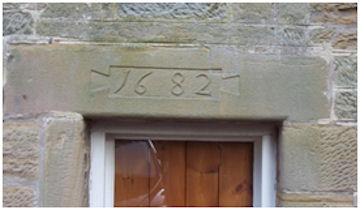
This was the area occupied by the central range of buildings of the Roman fort and included stone structures such as the praetorium or commanding officer’s house. During the preparation of the site in 1682 these remains were encountered and the head of an eagle carved on stone was discovered, which was subsequently built into the fabric of the new wing (Sibbald 1710). This is undoubtedly why the datestone on the central lintel of the ground floor doorway took the form of an ansate panel.
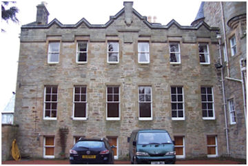
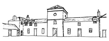
The 1682 jamb takes the form of a T-shaped building. The W/E element is a three-storey six-bay block with a large drawing room on the first floor; the N/S section, also three-storey, contained the large kitchen on the ground floor (the lower ground level providing it with extra head room) with a great fireplace in the north gable. South of the kitchen, at the junction of the two units, was a stair. The N/S segment has its own simpler datestone on a first-floor lintel facing east into the now completely enclosed courtyard. The south façade was clearly intended to impress with six windows on each floor placed in vertical lines. The ground floor windows have rounded margins, like those of the older block except that their outer sections are keyed to hold the harling leaving a wide plain margin. The fourth of these windows from the west, with the datestone, was originally a doorway, which has subsequently been narrowed and its lower half built up. The first-floor windows are larger and are provided with extra detailing in the form of a quirked edge roll to sides and lintel. The upper windows are again rounded – but have false horizontal gun loops incorporated into their sills. A sundial occupies a central location level with the top of the first-floor windows. The Roman numerals are rather worn – V to XII on the left and I to VI on the right. The faint traces of the inscription across the top are illegible.
In 1696 the Milne family sold Carriden to Colonel John Erskine, the first of many military career officers who were expanding the British Empire to own the house. For almost a century the house kept changing hands at frequent intervals and consequently required little by way of augmentation (we are indebted to Thomas Salmon for the history of its owners). In 1702 it was sold to General George Ramsay. His daughter, Jean Ramsay, succeeded to it in 1705 and she in turn was succeeded by her heir, William, Earl of Dalhousie, in 1708. Four years later his sister, Lady Elizabeth Ramsay, followed, and she again in two years’ time was succeeded by her son, Francis, master of Hawley. Then in 1719 the estate was sold to Colonel Francis Charteris of Amisfield. In 1736 his son of the same name succeeded as heir of entail. He held the estate until 1764 when he disposed it to Colonel Campbell Dalrymple. The following year Colonel Dalrymple began proceedings to have the church removed from the churchyard immediately to the south of Carriden House. The church building and the boundary walls were inspected by tradesmen and found to be in a ruinous condition, requiring £174 to be spent on them. As the location was inconvenient for the parishioners it was agreed to build a new church at Bonhardpans, and this was accordingly done the following year. The old church was taken down and the prospect of the house much improved. However, there was some disquiet amongst the local community over the break in tradition and the rights to the old churchyard were not so easily expunged. In January 1767 a “riot” took place when the son of a local salt watchman was buried in the new churchyard instead of the old one. Around this time a small narrow two-storey extension was added onto the west gable of Carriden House and its raggle can still be seen. It must have been relatively flimsy as it was replaced within a century and may have been little more than an entrance porch.
Later that year Colonel Dalrymple sold Carriden to William Maxwell, who was succeeded by his son of that name. Their family tomb can be seen on the north side of Carriden old church. In 1802 William Maxwell petitioned for the closure of the coast road from Blackness that ran up the escarpment to the east of Carriden House and then passed south of the house to Muirhouses. This was granted in 1805 and provided the house with greater privacy, though the route remained as a footpath. At some time after 1682 (probably around 1800) a small extension was added at the north-west corner of the house, in the re-entrant between the kitchen wing and the drawing room. This contained a ground floor entrance that led to the main western stair, avoiding the need to pass through private rooms. Outside, to the north, was a stone paved yard.
The estate at this time included the farms of Carriden, Stacks, Walton and Paddockhall. The large area of flat ground to the east of the house contained some of the best agricultural land and it was alternated between pasture and arable, let on a short term leases:
“The GREAT PARK of CARRIDEN, in pasture grass, for one year from the 1st January 1799. This Park contains about 186 acres, well fenced and watered, and is well known to be excellent pasture for both sheep and cattle.” Apply William Maxwell Esq the Proprietor. (Caledonian Mercury 22 December 1798, 1).
The following year it was reset for tillage for the three ensuing crops, having been in pasture for 13 years. The land was exposed at a public roup in lots of 10-20 acres. The farms generally had 19-year leases. That same year, for example, the farm of Paddockhall was let for that period. It contained 112 Scots acres of arable land divided into 13 enclosures, partly with stone sunk fences and party with ditch and hedge, with a new house of two storeys and suitable offices. At the time a great part of the lands was in hay and pasture, and about 22 acres sown with barley and oats and grass seeds (Caledonian Mercury 27 July 1799, 1). Walton Farm had 143 acres.
In 1812 Carriden estate was sold by the trustees of William Maxwell at the upset price of £56,000. It comprised 573 acres, of which 45 were under wood and plantation. The house and garden were valued at £1,910. The sale excluded the coal under Carriden Muir, which was reserved to the Duke of Hamilton. However, there was no living memory of this place, it having long since been divided up. The south part of the Great Park was called the Muir but had been under cultivation for many decades. The small settlement of Muirhouses may have provided some clue to its location, though it probably referred to a muir to its west forming part of Grange. At the time of the sale Stacks farm had been let to Mr Trotter on a 22-year lease from 1805 and Walton farm to Mr Graham on a 15-year lease in 1806. The following year the roup of the Great Park was advertised upon the Cross at Linlithgow, “cry’d thro the town,” and put on the church doors of Carriden and Bo’ness.
The garden was said to be in good order except for the espaliers. It had 180ft of hot wall, that is to say a wall that could be heated. The location of the early walled garden is uncertain but is likely to have been to the south-west of the house. Roy’s map shows a walled enclosure to the west, which may have been the vegetable garden, and a slightly large one to the east which would have been the lawn and formal garden.
In 1814 Admiral Sir George Johnston Hope took up residence. He intended Carriden as the seat of his new dynasty and set about improving the house and grounds. At the house the first task was to square off the north-west corner with a three-storey extension. The first-floor window on the west façade has the date 1814 engraved on it. Both windows here have quirked edge rolling, which from hereon became standard. John Gibb, stone mason, and Robert Meikle, joiner, both of Philpstoun, were the main contractors for the work and Robert Reid was the architect. A large tall retaining wall ran a short distance northwards from this new extension and then turned west to follow the crest of the escarpment. On the outside of the retaining wall, hidden from view, a cart track ran to the north side of the house and the courtyard. Inside the ground level was considerably raised to form a relatively flat garden area. A tunnel for pedestrians was incorporated into this work, leading from the new terrace down a flight of stairs and under the service road to a network of paths cut into the hillside (it is labelled as a subway on the OS maps). A terrace patio was constructed onto the west end of the house and an entrance formed from the window aperture directly above the old doorway. A large window/patio door was inserted into the end of the drawing room, opening on to the terrace.
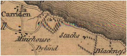
Between 1755 and 1766 the main road leading down the hill from Muirhouses to Cuffabouts was realigned. The northern end was moved eastwards so that it now skirted the new churchyard. Due to the steep slope the levels were built up as it passed the church. The movement presented the owner of Carriden House with an opportunity to create a level access route to the west. Prior to this the road to the house had been almost due south across the contours.
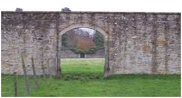
The grounds were laid out on a grand scale. The vegetable garden was moved to the far side of the Muirhouses Burn, where a massive walled garden was constructed. The four-acre garden became well-known for its herbaceous plants, nectarines, peaches and apricots – which did well on the south-facing walls. The garden is rectangular in plan measuring approximately 120m x 70m. The tall walls are made of sandstone rubble with internal red brick facing and external brick to the south wall, and dressed sandstone quoins, all capped with plain ashlar coping. There are arched openings in the south and west sides, whilst the grander gateway on the east has square piers. Glasshouses were placed against the north wall.
To the east of the walled garden was a formal rose garden and an intricate layout of paths with a small pond. A new drive was placed along the south side of the walled garden where a gardener’s house or lodge was built. Both the lodge and the broad bridge over the Muirhouses Burn were constructed by John Gibb. The lodge cost £213. It is a small single storey harled cottage and had an elongated hexagonal plan, with one window to each face – that to the east being blind and that on the south having the date “1818” cut into the lintel. The windows have Tudor hood moulds. Three tall octagonal ashlar chimney stacks emerging from the shallow pitched roof provided a strong feature. Originally it had a rustic porch on its west side.
(a)")
(b)")
Illus 22: The Gardener’s Lodge before and after renovation in 1990.
Nearby a yew hedge, 200yds in length, was planted. Terraced paths, holly hedges, bridges, and the extensions of the ha-ha enhanced the appearance of the grounds to create a country seat of note. New stone gate posts came from Brightons Quarry and Winchburgh Quarry. Holly, beech, oak, cedar, box, pine, almond, broom, thorn, juniper and laurel all feature in the list of trees planted. Slowly the walnut trees, plane trees, copper beeches and maples matured. It is said that there were four miles of walks and roads in the policy. These were under the ward of John Weir the gardener and required the services of John Fraser, mole catcher.
Another new drive was created out of the North Division of the Great Park. This was a deviation from the previous south road which now departed from the old one 430m south of the house and took a sinuous course further to the east to provide a grander approach. It was echoed on its east by an extension of the ha-ha east of the house.
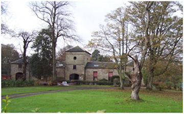
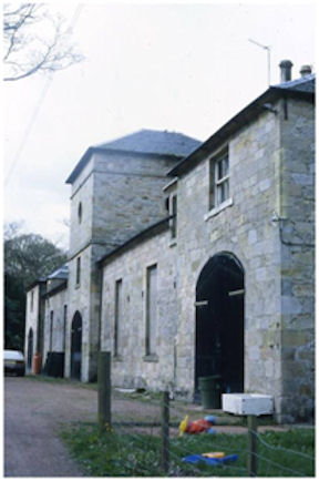
In 1818 the old home farm was regularised and Gibb and Meikle were again employed, Robert Reid, architect. A new coach house was constructed with a central three-storey tower housing a carriage shed on the ground floor and a doocot on the upper floors. The main façade faces the house and is symmetrical with two-storey arched pavilion-style coach sheds at either end. String-courses occur above and below the second floor of the central tower, the lower one bearing the date 1818. The pyramidal roof is slated and formerly had dormers on each side each with five openings for the birds. The 915 wooden nest holes have now been removed due to dry rot. The original estimate for the work had been £1,700, but extra items such as a stone trough, poultry house, pigeon house fittings, troughs for poultry, additional doors and windows, a boiler in the washing house, a chest for holding beans, washing tubs, a pig sty, alterations to the hay loft access, fittings for the harness room, a porch, steps for the coachman, a cistern and so on, brought the full price up to £1774.3.8. Buildings were added over the next decade to form a large square courtyard.
Internally, the stables were fitted with cast iron posts and railings which are now in Falkirk Museum. The floor had segmented purple bricks and drains. The north side of the courtyard housed some of the large number of workers required to maintain the estate. This range consisted of a row of single storey dwellings. The west range was of two storeys, with a cart shed at the south end. The south gable of the cart shed contained a large blind arch to match a similar feature in the south gable of the coach house wing. The quality of the stonework in the west range was, however, far inferior and incorporated fabric from the earlier home farm. The large rectangular courtyard was surfaced with chunks of whinstone.
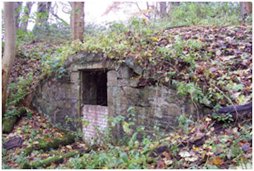
It is also probable that the ice-house which lies c90 m east of Carriden House was built during this major overhaul of the estate. It stands almost at the top of the wooded north-facing escarpment which would have protected it from the warmth of the sun. The brick domed ice-chamber is 3.2m in diameter and at least 2m deep below the foot of the entrance door which is on the north.
On the coast the sea dykes were repaired in 1818 and Gibb constructed the Carras Gate piers which were fitted with iron gates. The drive from here to the house was re-engineered to provide an easier course and surfaced with gravel. At the top of the escarpment it led directly to the house. The old path had provided a right of way for the parishioners from Blackness to get to the church adjacent to the house and they evidently still felt that the right existed for in 1819 a constable was placed there to watch over it and to prevent people from passing that way. Robert Stevenson, the engineer, was brought in to comment on the existing sea dykes and in 1824 the sea wall at Carras was rebuilt by Walter Gowans.
By 1819 the old churchyard had become “full of weeds and dirt and rubbish not fit for a dog to lie in” and the tall boundary wall was shading the house. It was therefore agreed with the villagers that the north-east corner next to the house, where there were no graves, should be rounded off. The west wall, where there were funerary monuments, was re-pointed and a stone pillar placed at its northern terminus, with a further one on either side of the new gateway in the south-west corner replacing the former gate in the south-east corner. The other walls were reduced to 2ft tall and surmounted by a stone coping and an iron railing 4.5ft high. The stonework was executed by Walter Gowans at a cost of £109 and the railing by Arthur Thomson for £160. Access to the gate was by a new spur road from the south which was hemmed in by tall stone walls – part of the controls put in place to ensure that the public did not roam freely.
The water supply to the house was improved by the construction of a reservoir or tank on the South Division of the Great Park by John Gibb in 1818 and the ditch/ha-ha beside the new drive led from it through the North Division to act as an overflow. The opportunity was taken to improve the other ditches and fences on the estate and to increase the liming of the fields. The fields on the home farm included the grass parks known as the North Division of the Great Park, Easter and Wester Schoolhole, Short Butts, Glebe Park, Catcraig, Shore Parks, Peasehill and Kirkbrae. The Glebe Park had been formed out of the site of the old manse and glebe. The South Division of the Great Park was in arable and compensation had to be paid to the tenant when the reservoir was constructed. New land had also been acquired at Little Carriden to augment that already in the possession of the estate. In 1820 subterranean drainage was introduced into the North Division.
During the middle of all this frenetic work Admiral George Hope died on 2 May 1818 and his son, James, inherited the estate. James was only ten years old when his father died and from the age of fifteen was serving in the Royal Navy. The estate was therefore looked after by his step-mother, Lady Georgina Hope. She continued the work of consolidating the private grounds of the house. In 1820 the old parish road from Muirhouses to the south-east was moved further to the south and the old route was taken up. There appear to have been no objections. In 1825 Lady Hope straightened the Muirhouses to Carriden path in the same area, shortening it and improving the surface – again there were no objections. When, however she set about uprooting the old way and planting its course with trees a group of local people threatened violence. Young James Hope had to obtain an interim interdict from the Court of Session to settle the dispute. (This is the route archaeologically excavated by CFA in 2020 in advance of a proposal to build a large number of houses).
James Hope had been born in Carriden House on 3 March 1808. Even though he was away in pursuit of his military career for most of his life he continued the improvements at home. The West Avenue had been lined on its south with beech trees and in 1838 he proposed that the public should be allowed to use it as a shorter more convenient access to the old burial ground than the existing ones. In return he wanted to close those old routes and applied to the county justices for authority to do so. Again there was vocal local opposition and the following year he dropped the proposal. The old burial road from Cuffabouts to the old churchyard is still a right of way, but that from Muirhouses seems to have fallen into abeyance.
Despite such disputes, the Hope family was seen by most of the local community as good estate owners. In the 1840s they built a school for girls at end of the West Avenue on the Carriden Brae, which they maintained at their own expense. Dated 1844 on a lintel overlooking the drive it presents a single storey to the road and two to the rear due to the sloping site. In 1861 the Ordnance Surveyors gave this account of it: “SCHOOL (FOR GIRLS): About 23 chains south of the parish church. This is a private school for the education of females and infants. It was erected by the Miss Hope of Carriden, who are the patrons. The teacher is Miss Slesser, who has a salary of £10 from the patrons together with the usual fees, house & c. The number of scholars varies very much, so that the attendance cannot be given.” A few years later a mixed school was established in the village of Muirhouses and for a few years they were run concurrently.
A two-storey lodge was also built at the entrance to the South Avenue in 1857. The east gable overlooking the gateway contains a hood-moulded window on the upper floor under a fretwork barge board and a piended bay window on the ground. A southward projecting porch has the date 1857 under its arched hoodmoulding.
(a)")
(b)")
Illus 28: The South Lodge with the Estate gate beside it.
The family members were staunch supporters of the movements to reduce the consumption of alcohol by the working classes. Throughout the 1850s and 1860s they hosted visits to the grounds of Carriden House of the Bo’ness and Carriden juvenile abstainers. In October 1852 some 250 youths visited and after a period of recreation they were supplied with fruit, bread and sweet milk by Miss Hope. The adults escorting them had a cup of tea in the house. Miss Hope presented two banners for them to march behind. Children from Carriden, Grangepans and Blackness schools also had their annual excursion to the grounds of Carriden House.
Work also continued on the house. In 1849 the rather awkward access connection between the 16th century block and the 1682 jamb was overcome by placing a small rectangular insert into the courtyard and this date appears on a first-floor lintel. The extension serves all three floors and its flat lead roof is hidden by a simple short battlemented parapet. Again the windows margins have edge rolling.
That same year a two-storey porch extension was put into the re-entrant angle, greatly enlarging its predecessor. The entrance was still on the ground floor and the lintel of the main doorway was ornamented with raised mitred crosses set in a sunken rectangular field between roll moulded sides. The date 1849 was set on the upper moulding. The south-west corner of the porch took the form of a pilaster with rounded corners, meaning that the doorway was set back a little in order to emphasise it. The visitor would enter the main door and then turn right to the lower straight flight of stairs put in place in 1602. There was probably a rectangular window above this doorway, with two on each floor of the west wall set vertically above one another. The west wall was harled. The flat roof was covered with lead and presumably the wallhead had a similar parapet to that of the courtyard extension.
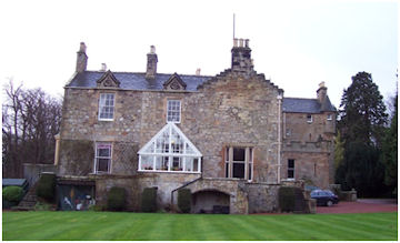
Around this time the north-west block of 1814 was furnished with two projecting triangular window bays at first-floor level overlooking the Forth. These observation windows were then in vogue and can be found, for example, in a contemporary building at Weedingshall (see illus 19).
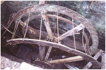
The large amount of woodland on the estate produced a valuable crop and in the 1850s a water-powered sawmill was tacked on to the west side of the stable complex. Mill ponds were created by damming the Muirhouses Burn. When digging the pit for the water wheel a Roman concrete floor was discovered. This is now known to have been part of the bathhouse of the Roman fort. The wheel had a cast iron frame which is still in position, though it was broken up in 2018.
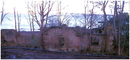
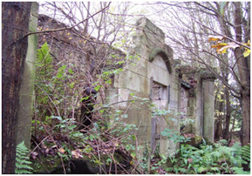
Around 1852 the footpath along the coast was realigned in the area known as the Shore Park. A new path was provided along the top of the sea wall and a tall boundary wall was built along its southern side. It was probably also at this time that the lodge at the Fishery was built to help to police this new route. (This building is now ruinous. In the 1950s the Paul family lived here and it doubled as a sweet shop.)
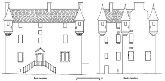
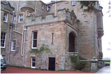
1863 saw a great deal of embellishment to the south façade of the house, including the remodelling of the recently erected porch. The entrance was now moved to the first-floor level. This meant filling in the old doorway and removing its lintel. Above this the wall was demolished between the pilaster and the old tower house. The entire south façade above the ground floor was rebuilt using a higher quality grey sandstone incorporating a massive Gothic arch. This was reached by a broad flight of ten steps set between parapet walls ending in short pillars capped with ball finials. The Gothic arch gave access to an open foyer, behind which another entrance doorway was constructed in a new cross wall. This required the construction of a cross wall on the floor below it for support. The new doorway housed the same decorative motif as its immediate predecessor, but the old lintel was not used here. Instead it was inserted into one of the ground floor windows on the west side of the extension and this was converted into a doorway.
On the upper floor the wall housing the new entrance required the infilling of the window on the west wall at this point, and this was replaced by a decorative vertical splayed arrow loop. Entering the 1863 main doorway now took the visitor into an entrance hall. To the right was the entrance to the first-floor study with the ornate 17th century plaster ceiling. However, entry to the 1602 staircase from here was impractical as one flight lay on the floor below and the other on the floor above, so a rather odd compromise was reached by placing a wooden stair against the back wall of the 1849 extension. It is reasonable to assume that it was at this time that the central first-floor doorway on the east side of the house was made into a window by raising the base and inserting a mullion. The external stairs were removed and the stone may have been used in the new constructions.
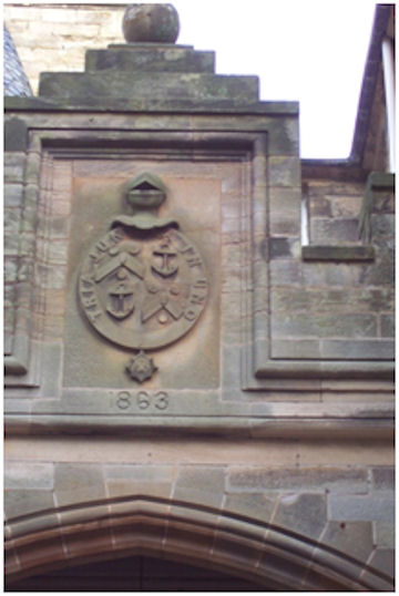
The wallhead was raised slightly and the previous battlemented parapet replaced by a deeply castellated one of higher quality ashlar made of grey sandstone. It was carried on a single moulded corbel course and the battlement had raised corners with a small corbelled sham turret at the free south-west corner sporting a decorative round gun loop. A square armorial panel was set in a moulded recess above the Gothic arch where the battlement was also raised and finished with a ball finial. The armorial panel depicts a helm, face-on, on top of an oval band or ribbon from the bottom of which is suspended a “star” containing a cross. The Latin inscription “TRIA JUNCTA IN UNO” (three joined in one) occurs on the ribbon. The star and motto are those of the Order of Bath, James having been made a knight of that order on 9th November 1860. Inside the ribbon is a coat-of-arms, quartered: first and fourth a chevron between three bezants, a laurel leaf; second and third an anchor. These are the coat-of-arms of Admiral James Hope. Below is the date 1863.
This date is also found on the slightly corbelled parapet wall now installed along the south wallhead of the 1682 wing. Its parapet has coved coping stones and a gablet in the centre where a chimney occurs. The west façade, to the north of the gable, was similarly treated.
The remodelling extended to the older parts of the house. A large square three-bay oriel window was grafted onto the south gable at second floor level. It rests on four courses of convex corbelling and has three tiers of stone coping on top. Below the oriel window is a trefoil with a decorative central circular gun loop; above the window a square moulded recessed panel contains an anchor superimposed upon the monogram “JH” for James Hope, surmounted by a moulded cornice upon which is a low relief geometric design.
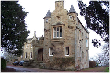
On the east façade the restrained old symmetry was broken up, though the vertical symmetry was retained. It had consisted of three vertical sets, each with four windows. Now a two-storey oriel window was inset into the southernmost line at first and second floor levels, and a single-storey oriel window at second floor level on the northernmost line. The southern example had a gently curving front with four slender projecting corbel courses at the bottom and two tiers of stone coping for the roof. The lower plain window has a large central opening with a narrow window on either side, whilst the upper window has three equal-sized windows surrounded by roll moulding. Between the two windows are two small quatrefoils. The narrow slit window of the basement below these was replaced by two widely spaced slits. Between these, level with their lintels, is a circular window surrounded by concentric circles. The canted southern window is three-sided with a large central opening and is supported on three concoidal courses of corbelling, all under a slate roof. The window below it was partially replaced in a style similar to its predecessor. It was probably also at this time that the eaves course of the five corner turrets was renewed and an additional course inserted below it, raising them slightly. Fishscale slates now decorated their conical roofs. The fluted or cloverleaf gun loops may be copies of the original.
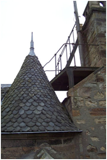
At the top of the house an observation tower was constructed, reached by a series of iron ladders. This square stone tower has a perforated slab balustrade with a square chimney can at each corner. Appropriately it was called the “Crow’s Nest.”
Rounding off the corner of the graveyard allowed further landscaping to take place on the south side of the house. The ground here was levelled up to suit the new entrance and this continued to the west. The surrounding area was brought up to the level of the ground floor window sills.
Despite the dispute with the local population over the right of way to the old graveyard adjacent to Carriden House, the relationship between the Hope family and the community was strong. In December 1877 when Admiral Sir James Hope KCB married for the second time, to Elizabeth R Cotton, daughter of Lieutenant-General Sir Arthur Cotton in London, a grand triumphal arch was erected at the entrance for his return to Carriden. There was a torchlight procession with the Carriden Brass Band at the head.
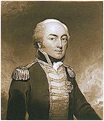
Admiral Sir James Hope, KCB, had entered the navy when young. In the early period of his service he was employed with the African squadron in the suppression of the slave trade. He served in the Baltic during the war with Russia in 1854 and 1855, and became the commander in chief in East India, China, West Indies and North America, and afterwards at Portsmouth from 1873 to 1878. Perhaps his most famous exploit came when he was only a lieutenant stationed at the River Plate in South America. The enemy had thrown a cable across the river and during a tremendous fire he personally cut the boom with a chisel enabling the fleet to pass up the river. After his life at sea he became the principal naval aide-de-camp to Queen Victoria and was a deputy-lieutenant and justice of the peace for Linlithgowshire. As well as the welfare of his tenants and estate workers he took a great interest on the promotion of British Workman Public-houses and the welfare of seamen. At his own expense he built a large building in Bo’ness for the purpose of being a coffee-house, which after his death continued to be supported by Lady Hope.
In his retirement James Hope did much to improve the lot of those around Carriden. He bought up many of the poor-quality houses in the adjacent village of Muirhouses which belonged to the Cadell family and were occupied by miners. These were demolished and replaced by substantial stone cottages in a Tudor style, eventually creating the model village which adorns the area to this day.
James Hope died at Carriden House in June 1881 aged 72. On his death Carriden was for a time life-rented by his widow, and then held by his sister, Miss Helen Hope. On her death at the age of 83 in May 1890 it passed to Colonel George Lloyd Verney, second son of Sir Harry Verney of Clayton, Buckinghamshire, whose mother was a sister of the Admiral’s. Having estates elsewhere, Carriden was initially put up for let, furnished:
“CARRIDEN HOUSE and SHOOTINGS, with Offices, Stable, and Coach-House. The House contains 2 Public Rooms, 6 bedrooms, Bath Room, & c.: ample Servants’ Accommodation; situated within 3 miles of Linlithgow and 2 miles of Bo’ness. The Shootings, which are of the usual Low Country description, extend to upwards of 700 Acres…” (Falkirk Herald 16 August 1890, 1).
Lets, however, were infrequent and George Lloyd Verney visited Carriden House on several occasions. In 1892 a sundial with the date on it was placed next to the mounting block on the south side of the house to commemorate one such. The conical spires of Carriden House were each surmounted by a vane in whose zinc plate were cut two sets of initials of the Verneys, as E.H., L.V., etc – ten in all. Inside the house was full of typical Victorian clutter. Mementoes of foreign visits abounded, such as a fur headdress of the explorer, a pair of fine elephant tusks, a chair built of reindeer horns. There were also examples of more local history including an alms dish of Carriden Church dating from before the Reformation and last used in 1892; and a baptismal dish inscribed “For the church of Carriden, 1693.” In the drawing room there were numerous books in the book cases that lined the north and east walls. Part of the book cases on the east wall opened up to reveal that it had formed the back of a door. The map collection in the dining room included a plan of Carriden in 1757.
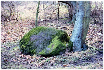
It was probably at this period that a large glacial boulder to the south of the stables adjacent to the west drive was inscribed “THE/ WITCHES STONE”. Tradition has it that the last of the Carriden witches was burnt here. The valley nearby was called the “Witches’ Neuk.” A story goes that soldiers from Holland wandering in these parts saw witches flying in the air, and that “the Deil and an auld woman riding the clouds cast oot and ane wanted to kill the ither,” when this stone was flung by his Satanic Majesty from Cockleroy. The stone is also known as the “Muir Stane” and this may provide a better indication of its original significance. It was probably simply a boundary stone for the lost Carriden Muir. Further down the Carriden Glen was a mound which was known as the Smuggler’s Grave. It lay by the face of the rock under a yew tree.
In 1892 George Lloyd Verney re-opened the thorny issue of the rights of way. Hearing that the Parochial Board were looking for land for a graveyard, that created in 1766 having been closed to new burials because there was no space left, he offered to provide a site along with access and appropriate boundaries in exchange for the closure of the footpaths. Once again a determined opposition ensued creating a hostile environment. The paths remained open, but they were now heavily fenced about. Numerous signs were erected telling the public to stick to the paths – a habit they had neglected.
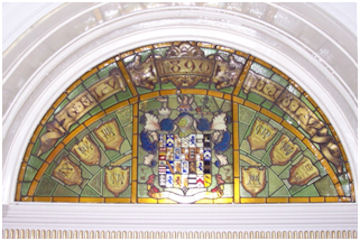
In this period the great fireplace in the 1682 kitchen was refurbished in order to take a cast iron range. The old arch was removed and replaced by a huge stone lintel. The moulded archway was then placed rather asymmetrically into the retaining wall of the west terrace to form a garden feature, requiring a buttress on its south side. The wife and children of Colonel George Hope Lloyd Verney are celebrated in the semi-circular stained-glass window, which surmounts a doorway at the foot of the west wing staircase. On the colonel’s death in June 1896 he was succeeded by his eldest son, James. The following year Carriden House was let to Sheriff Melville of Lochcote.
Now further disputes arose about the right of way along the shore and that from the shore road at a point called the Irongates or Carras Pans to the old burial ground. Both of these were used by parishioners from Blackness. Around 1852 Admiral Hope had had a new road made outside the Shore Park which the public had used since, but it had become impassable with the result that the public was entering the Shore Park again. A dozen or so scholars used the shore road to get to school each day, there being no school in Blackness. After numerous meetings and exchanges, the 1852 road was repaired and the both paths were kept open.
After Sheriff Melville, the next tenant was Mr J C Burns of Glenless, Hamilton, who was a well-known Glasgow shipowner. His daughter was married at Carriden House in fashionable style in June 1898.
In 1904 attempts were made to form a special water district for Muirhouses and the surrounding area. The inhabitants of Muirhouses and the six families at Bonhard House had to carry the whole of their water from Carriden House or Cuffabouts. The lodges at Carriden were supplied from wells near them which ran dry in the summer and their occupants too had to get water from Carriden House. The scheme, however, was going to be expensive. Things came to a head in 1907 when tests of the water supply for Carriden House showed that it was unfit. Part of the problem seems to have been the vegetation surrounding the upper reservoir. By 1910 Carriden House and the surrounding dwellings were connected to the public water mains.
The walled garden was still a valuable source of food and income. In 1909 a substantial Classical single-storey house was built against the north side of the walled garden for the head gardener. The walls were of snecked tooled sandstone and the north façade had a central doorway with the date “1909” in the tympanum. To either side was a corbelled canted bay window with lattice glazing below a heavily moulded cornice course. Framing the facade, at each end, was a bold projecting angled Tuscan column.
James died in November 1909, when the estate passed to his brother, Harry Lloyd Verney. James had left an estate in the UK of the gross value of £10,983 and the family were not short of money. However, they had rarely used Carriden House and the bitter disputes over rights of way had taken their toll. The estate was put up for sale in 1912. That summer William & Mrs Burrel of Glasgow took up temporary residence.
“By order of H.L. Verney, Esq. SALE OF THE CARRIDEN ESTATE, occupying the most beautiful position overlooking the Forth of Forth, adjoining Bo’ness, comprising a Charming Family Residence, known as “CARRIDEN HOUSE,” 3 Miles from Linlithgow Station, containing 5 Reception Rooms, 17 bed and Dressing Rooms, Beautiful Pleasure Grounds and Gardens, and Good Stabling. The Agricultural Lands are some of the finest in Scotland, and afford good shooting, also the Valuable Freehold Farms known as “STACKS FARM” and “WALTON FARM,” and Minerals. The whole comprised an area of about 737 ACRES, for Sale in Lots as follows:-
Lot 1. Carriden House, Home Farm, and Parks. 276 Acres.
Lot 2. Stacks Farm, 226 Acres.
Lot 3. Walton Farm, 235 Acres.
The Estate is of the Annual Value of £1300 per annum…” (The Scotsman 26 October 1912, 3).
The upset price was set low at £23,000. The tenants of the farms decided to bid for the lands that they were renting and the Marquis of Linlithgow was considering the house. However, before the public roup took place the whole estate was acquired by private bargain by Joseph Constant of London, who became an absentee landlord. He was a very active entrepreneur backed by a syndicate with substantial capital and was accustomed to making things happen. The sale price is reputed to have been as low as £20,000, plus £520 for the oil engine, the electric lighting plant, and so on. The intention was to move a shipbuilding yard from Montrose to Carriden and the syndicate had been looking for land in the Bo’ness area for some time. He immediately visited Carriden and inspected the foreshore with the manager from Montrose and reported that much work was needed to reshape the coast to adapt it for shipbuilding under the name of the “Carriden Shipbuilding Co.” The coastal strip had been the main concern of the new owners and so the existing farm tenancies were continued – James and James Paul for 19 years at a rent of £390 per annum. Carriden House was to be let furnished. The shooting over the estate was let to the Marquis of Linlithgow.
An inspection of Carriden House revealed that it was full of clutter and Constant decided that the house would be easier to rent out without it. It would also bring in a financial return. The furniture included:
“REAL ANTIQUE SHERATON SIDEBOARD, Diningroom Suite, Dining Table; Writing, Work, Occasional, and other Tables; Tapestry Covered Lounge, Divan, Devotional, Silk, and Occasional Chairs; MAHOGANY TALLBOY SEMI-GRAND PIANO, by Collard & Collard; bedsteads, bedding, Wardrobes, Chests of Drawers, Dinner and other Services, China, Library of Books, Dressing Tables, Glasses, Washstands. TURKEY, AXMINSTER, PERSIAN, and BRUSSELS CARPETS AND RUGS; Silk and other Curtains, Electric Table Lamps, Harmonium, cameras, Kitchen utensils, and Miscellaneous Effects; and Oil painting, Engravings, and Water Colours, & c.” (The Scotsman 13 September 1913, 15).
The Motherwell Times of 3 October 1913 believed that this was a case of asset stripping and reported that Carriden House “is this week to be robbed of its internal splendour through the operations of the auctioneer.” It particularly pointed out the war trophies, a tapestry and metal relics. It was not known if the last letter written by Nelson before his death which had been at the house was included. The library consisted of over a thousand volumes. Much of the valuable timber on the estate was also sold off.
Joseph Constant did not live to enjoy the fruits of the sale. The house was still empty at the start of the First World War and its proximity to Rosyth gave rise to rumours of German spies making use of it. On 24 October 1914 the Falkirk Herald ran the following story:
“In order to allay the growing suspicions of the people in the combined parish, police officers from Bo’ness the other day visited the mansion-house of Carriden, and made a careful inspection of the building and its surroundings. The officers declare they found nothing but empty rooms and apartments, quite innocent of anything that could possibly be used to help the Germans now or when they come to effect their much spoken of landing on these shores. Nervous people can therefore sleep soundly – there is no fear of any such raid and certainly there is no truth whatsoever in the reports there is “wireless” or ammunition secretly store away in the vacant mansion… We all deplore the fact that it has stood so long empty, and we have long since ceased to inquire what the owner intends to make of the property… It seems what gave rise to the suspicion that improper use was being made of the house was this: some people passing along heard a peculiar noise emanating from the mansion. This was the electrical plant in operation, the caretaker making periodical tests, just to see that it is in working order.”
The house was soon to be furnished as an auxiliary hospital for wounded soldiers by Mrs Constant, the proprietrix, and leading Bo’ness citizens. It officially opened on 19 April 1915 when twelve patients arrived from Craigleith. At the request of the authorities the number of beds increased to 15 by the end of the year, the extra beds and equipment being gifted by Lady Murray. This was extended to 20 in July 1916 when the “Kitchener Ward” was opened, the beds provided by Mrs Constant. In September that year it received the first Royal visitor to Bo’ness in the shape of Princess Christian. With the Marchioness of Linlithgow she was received by Commandant Murray and Dr Fischor, the Medical Officer. Carriden auxiliary hospital closed after almost three years of distinguished service on 30 March 1918.
In late 1915 or early 1916 Walton Farm was sold to James Paul. During the period of the auxiliary hospital the remainder of the estate, consisting of 730 acres on the farms of Stacks, Dyland, and Walton, together with the house, was sold in November 1916 to the Bridgeness Coal Company, whose main shareholder was William Cadell, with the intention of extending the company’s mining operations in that direction. Part of this work would have been the use of the waste from the colliery to reclaim land on the foreshore and it was also hoped that the Admiralty would extend its boatbuilding operations to that vicinity. In the event this never happened. The house was leased to James Calder from 1922 to 1923. In October 1923 the Bridgeness Coal Companay sold the farm of Stacks, Carriden Farm and Carriden House to John Paul, tenant farmer at Stacks and the brother of James. Their father, James Paul had come to Walton Farm as a tenant 33 years before
For several years Carriden House stood empty and in December 1925 Reverend Snow pointed out that with the shortage of housing it ought to be converted into flats. The following year it was leased to William Gardner Thomson, director of a local firm of timber merchants called Thomson and Balfour. The firm made doors and windows, and it would seem that they were responsible for the conservatory entrance placed on the west terrace.
To help to overcome the housing shortage 24 steel houses of the Weir type were officially opened at Little Carriden in February 1926. They consisted of a living room, two bedrooms, kitchen, bathroom and a scullery. Each house had cost £240 to erect and was rented out at £18 a year. Another government initiative was the construction of a new road along the coast from South Queensferry to Bo’ness. The route was surveyed in 1931 and the owners of Carriden and Hopetoun estates were informed of the intention to carry it through. Like the shipbuilding yard and foreshore reclamation this also lapsed into abeyance.
William Gardner Thomson was a native of Bo’ness and took a leading role in many organisations. He was very active in politics and hosted numerous garden fetes at Carriden House for the Unionist Party. He was knighted in 1935 for this work. He was a justice of the peace, a town councillor and a member of the Forth Conservancy Board. His wife was prominent in the Girl Guide movement. Upon taking up the tenancy of the house he commissioned Matthew Steele, architect, to supervise its internal renovation. He also hired a team of gardeners to bring the grounds back into condition. These were opened as part of the Scotland’s Gardens Scheme in September 1932 to support the local nursing association and this was repeated for several years. The Bo’ness and Carriden Band played on these occasions. The rose garden to the west of the steading was revamped. A visitor commented that here there were three notable Cypress trees over 250 years old, as well as two tulip trees which had yellow blooms in July.
Sir William Gardner Thomson died at Carriden House on 15 February 1938 aged 63. His 14 year lease of the house and its grounds from Mr Paul still had two years to run. Lady Thomson moved to London the following year to be close to her daughter and the tenancy of Carriden House was transferred to her son William Napier Thomson who was now a partner in the joinery at Bridgeness. During the Second World War the company made motor torpedo boats for the Admiralty. Napier Thomson became a platoon commander of the local Home Guard and in 1942 the commander of the Bo’ness Sea Cadets.
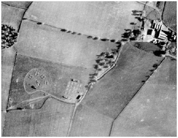
An anti-aircraft battery was established on the small hill to the south-west of Stacks Farm as part of the ring of defences for Rosyth Naval Yard and the Forth Bridge. As well as the four gun emplacements there was a small collection of huts and a brick-built canteen. The men from the battery walked into Bo’ness past Carriden House when off duty and there was a counter flow of civilians in the opposite direction. Barn dances were held at the farm. By 1943 the air battle in Scotland had calmed down and the guns and their crew were moved down to the beleaguered city of London. Dummy guns were put in their place at Stacks and paths were cut over the grass between them to convince German spotters that it was still manned.
After the Second World War the demand for electricity soared and coal-powered generating stations were built at Longannet and Kincardine. In anticipation of further demand the South of Scotland Electricity Board bought the Carriden estate and the necessary wayleaves in the late 1960s. However, the new power station was never required and the house survived, though it was allowed to deteriorate. In 1977 Carriden House with nine acres of ground was purchased by a couple with businesses in Bo’ness, Tom and Anne Barkhouse. A large amount of money was spent on repairing the roof and replacing lead. The intention was to raise some revenue for its upkeep by having a touring caravan park in the grounds as part of the increased tourism of the area. Access problems meant that this did not occur, though the house was used for bed and breakfast accommodation. The interior was slowly restored. A steel girder had to be inserted above the west wall of the old hall where the substantial stone wall had been replaced by a much narrower one in brick. In 1996 the house was sold to Graham and Barbara Blackbourn and the Barkhouses moved to the old coachhouse. The Blackbourns continued the work on the house and the catering side included weddings. The basement was brought back into use as offices. 2016 saw Carriden House change hands yet again – and so the story continues…
Sites and Monuments Records
| Carriden House | SMR 305 | NT 0250 8083 |
| Carriden House Doocot | SMR 17 | NT 0237 8075 |
| Carriden House Gardener’s House | SMR 308 | NT 0216 8080 |
| Carriden House Ice-house | SMR 61 | NT 0265 8087 |
| Carriden House Inner Lodge | SMR 309 | NT 0208 8072 |
| Carriden West Lodge | SMR 310 | NT 0188 8075 |
| Carriden South Lodge | SMR 1950 | NT 0198 8022 |
| Carriden House Stables | SMR 306 | NT 0235 8077 |
| Carriden House Walled Garden | SMR 307 | NT 0217 8077 |
| Witches’ Stone | SMR 1237 | NT 0230 8067 |
Bibliography
| Bailey, G.B. | 1991 | ‘Doocots of the Falkirk District’, Calatria 1. |
| Bailey, G.B. | 1992 | ‘Ice-houses of the Falkirk District’, Calatria 2. |
| Bailey, G.B. | 2013 | The Forth Front: Falkirk district’s maritime contribution to World War II. |
| Salmon, T.J. | 1913 | Borrowstounness and District. |
| Sibbald, R | 1710 | The History and Description of Linlithgowshire |
G.B. Bailey (2020)
