
A: Hamilton Reclamation of 1474 – Hainings
James Lord Hamilton is known to have reclaimed a large amount of land in his territory at Kinneil by permission of the king in the mid-15th century. This land was secured to him and his second wife, Mary Stewart, sister of James III, by a Royal Charter in 1474 (Salmon 1913, 26). This is probably the land referred to in another charter of 1540 as “terras infra mare.” The sea dykes needed constant attention and every now and again they crop up in the estate papers. On 15 October 1701, for example, Daniel Hamilton, the estate chamberlain, wrote:
“I was with the Bailey yesterday visiting the sea dykes and the course of Avon watter where the sea hath made considerable encroachments upon the Kersefield and will doe still more and mor if not prevented by wiers and buttrises and this cannot be doon without both great tymber and great stons as well as very much work and laboure”
(Hamilton Papers GD406).
In1747 it was noted that the sea dykes and banks between Kinneil and the River Avon were in a bad condition and so brushwood and young fir trees from the plantations were allocated for the repairs (Hamilton Papers GD2177).
The sea dyke is shown on Roy’s Map of c1755. About 1772 the then Duke of Hamilton had a sea dyke constructed at Kinneil Kerse of clay faced with stone pitching. This may just have been a re-facing of the existing bank and it shut out the sea from a flat part of the parish some 450 acres in extent (Cadell 1911). It was said to have been constructed to defend rather than gain land, which would be consistent with a rebuild. Where the dyke met the coastal road in the east was known as “Dykeneuk.” Here there was a clap drain through the bank and a little further east the Deil’s Burn entered a wide bay.
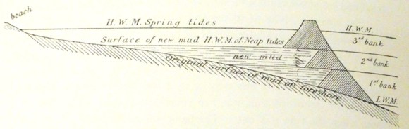
The reclaimed land was low lying but probably only flooded periodically at spring tides. It lay on the east side of the River Avon which at that time meandered laterally across a wide area and also had to be restrained. The length of banking was therefore in the region of 2.5km. It seems to have consisted of two zones. The inner was made up of narrow fields aligned south-east to north-west bounded by open ditches and hedges which drained northwards into a west/east ditch. These strip enclosures gave the area the name of “Hainings.” Beyond that was a more open outer area which probably served as salt marsh for pasture known as “Kinneil Kerse.”
B: Forth Conservancy Scheme – Avon to Snab
In 1921 the Forth Conservancy was constituted by an Act of Parliament and was financed by a levy on shipping on the Forth. Its primary object was to improve the Forth shores from the Forth Bridge to Stirling. By coincidence, the Kinneil estate came up for sale in 1922 and the Conservancy was able to acquire the foreshore between the River Avon and the Snab. The Conservancy Board, under the chairmanship of the Earl of Elgin, decided to experiment with land reclamation on the foreshore at Kinneil and H.M. Cadell, who was one of the Board’s members, acted as the local consultant and advisor. Kinneil was chosen because its mudflats were only covered by shallow water at high tides and there was a demand for industrial land in the vicinity of Bo’ness. Such usage brought in higher rents than agricultural land. It also had the massive advantage of having huge pit and iron furnace bings on its eastern margin which could be used as a source of heavy raw material for the necessary embankment. Part of these bings was on the Conservancy land, though most was on that belonging to Bo’ness Town Council. The Council readily agreed to their neighbour’s clearing 1.4 acres for them. One disadvantage was the presence of three streams – the White Burn, the Deil’s Burn and the Gil Burn.
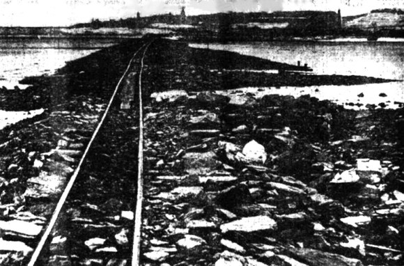
To keep costs to a minimum the Board decided to use the process of warping to slowly raise the ground level within a lagoon. £5,000 was put aside for the first phase. In October 1925 the area was surveyed and the line of the bank was marked by poles placed in the mud by Captain E Roynon Jones R.N., the marine superintendent of the Conservancy Board. The position of the enclosing dyke was cautiously placed well above the low tide mark. The initial dyke was to be 4ft high, making its top 4ft above Ordnance Datum, that is to say 13ft above the low tide level. As such it was covered by every tide at high water. It was designed to enclose an area of between 303 and 310 acres, forming a lagoon inside which the tidal water-containing mud would be retained. Here the mud would silt up, and the clear water was then allowed to run out. The bank was to start from the north side of the old Slag Hill at the Snab, and run due west for a distance of 1800 yards to the edge of the river Avon, where the river flowed across the mud. At the 1800 yards point, where the mud was higher close to the edge of the river, the bank would turn in a south-westerly direction and run for about 400 yards towards the old sea dyke at Kinneil Kerse Farm. Work began on this preliminary bank on 1 December 1926. A capable manger, Alex McCulloch, was found, and he selected a good squad of men, mostly unemployed miners, who worked zealously under the tidal conditions at the ordinary standard wage rates of a day usually of 9 hours between 5.30am and 11pm. The stated starting and finishing time were so far apart because work was often interrupted by the tide.
The work proceeded well and by mid-April 1927 the reclamation bank had been carried out for 600 yards. £4,000 had already been spent on the scheme, and about 30 workmen were employed. £2,500 more was allocated to the scheme. The outer face of the bank was pitched with heavy stones to protect it from the waves and these were then covered with a dusting of the iron slag. The latter welded or rusted together and formed a solid covering. It was at this time that arrangements were made with the Kinneil Colliery, which was still working, for its daily rubbish to be at the disposal of the Conservancy Board. Even though the embankment had not been completed, mud was deposited behind it by the tides. It was estimated that by May that this amounted to around 2,500 tons of silt.
At this point the working method had been perfected. Wooden sleepers, side-tipping wagons and a lightweight petrol locomotive were purchased. A single line of rails was laid upon the wooden supports which rested upon the mud, and the rails were carried out several yards in front of the bank at about 1½ foot above the level of the mud. The 20-horse power petrol locomotive then hauled the side-tipping bogeys, which enabled a train of bogeys to be emptied very quickly. With end-tipping wagons double rails and crossings would have been required. At the end of that May nearly 20,000 tons of rubbish had been emptied.
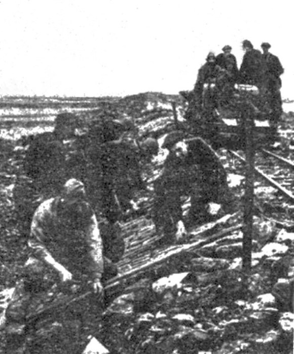
Illus: The Preliminary Bank with the Light Railway and carefully prepared pitched face.
At regular intervals along the bank large tubes, varying from 2½ to 3 feet in diameter, and from 35 feet to 50 feet long, were placed on the level of the mud through the bank. These steel tubes were fitted on the landward side with flap valves automatically controlled. The valves opened inwards so that the inflowing tide could enter, but the flowing tide could not escape, thus retaining the muddy tidal water until the mud was deposited. These temporary tubes were got by H.M. Cadell during dismantling operations at Dalmeny Oil Works. For the permanent drainage of the reclaimed land more substantial pipes were laid measuring about 20 inches in diameter and half-inch thick. These too were salvaged to keep costs down – being old masts of ships.
In mid-December 1927 the enclosing embankment joined the sea bank constructed 150 years earlier and the lagoon was secured. The bank varied in height from 4ft to 7ft and was intended eventually to be raised to its full height of 14 or 15 feet. At this stage some 50,000 tons of rubbish had been used. During the year, and long before the bank was finished, the silting went on, and extended right back to the beach, 900 yards from the line of the bank. The mud close to the bank rose over one foot at the east end, and at one deep place it silted up three feet in a short time. Over an area of 50 acres an average deposit of half a foot had taken place, equivalent to some 50,000 tons of mud extracted from the sea.
Late in 1926 Bo’ness Town Council started to tip all of its refuse within the shallow end of the lagoon at Dykeneuk. It had just converted from horse-drawn carts to using motor transport. Within a year more than two acres had been raised above the sea level in this way. The Town was delighted to have the free use of a coup.
An experiment designed to promote the accretion of mud had also been going on for several years at the shoreward margin of the enclosure. About 50 years earlier a kind of sea grass new to Britain was observed to have established itself on the south coast of England. Spartina grass had accidently been imported from America and Canada where it had assisted in the reclamation of large areas of mud such as at the head of the Bay of Fundy in Nova Scotia. After it took root on the English Channel it spread rapidly and formed a thick covering of tufts and mat-like stems over the mud, although covered by the tide every day to a depth of two or three feet. The plant spread both by seed and by long roots and suckers, which extended through wet mud, and only flourished in such soil. Spartina grass grew best in places with a warm summer, but in 1914, Dr W G Smith of the East of Scotland College of Agriculture obtained, by way of experiment, some roots from the English Channel and planted them in the mud at Kinneil Kerse Farm before the Forth Conservancy had acquired the ground. These plants grew, and it was thus found possible to acclimatise them in the colder Scottish soil. A further patch was obtained in 1918 by H.M. Cadell and planted at another and slightly higher spot on the beach. These also spread, but the seed never ripened and so here the plant only spread by its roots. A further patch was planted by the Conservancy in 1927 at the same place. The hope was that it would produce a salt marsh in which the silt in the tidal water would be retained and natural accretion occur. Although spartina has strong and rather coarse stems, it could still be used as grazing for horses and cattle on the salt marsh ground covered by occasional tides. This was the first experiment of the kind in Scotland.
£7,897 had been spent by the Forth Conservancy on the Kinneil reclamation by December 1928. However, of this £2,600 had been for the purchase of the rails, sleepers, tools, oil, locomotive, tipping bogies and housing. The primary bank had thus cost £5,297 which was £3,000 less that the lowest offer made by a contractor – the difference clearly being the equipment. The direct labour force was then able to utilise this equipment for raising the bank, making a substantial saving. A considerable amount of silting had occurred within the reservoir – though not as rapidly as had occurred earlier at Carriden. The difference was put down to the less stormy weather which reduced the energy in the system meaning that less mud was carried in suspension. In the spring of 1928 it was decided to heighten the bank, and raise it 2 feet to 6 feet above O.D., which was about the level of high water of neap tides. This was more easily accomplished as the existing bank formed a solid foundation, and the well-pitched outer face with iron grouting prevented much damage by the waves. The raising of the bank was completed by the end of that year.
The corner of the east end of the lagoon was shallow and during 1928 it was partly levelled up with rubbish brought by the LNER and emptied by the Conservancy. Between 2 and 3 acres were thus completely raised up above the level of high tides and made available for industrial use. But the filling up of a 9 feet deep basin, even with rubbish supplied in trucks free of cost, was still rather a costly operation per acre and the Board’s revenue from shipping dues had declined. To October 1930 it had spent over £12,000 on the Kinneil scheme.
In 1932 the next phase of the operation was undertaken. The lagoon was divided into two compounds by a bank at right angles to the sea wall raised to a height of 13 feet above ordnance – a western one of 250 acres being under siltation; and the other, of 50 acres, being entirely cut off from the sea. The larger compound still had a gap in the outer wall at the west end and through it the incoming tide still flooded the lagoon with mud-laden water, and clear water was sucked out through ducts in the wall at the eastern end. The ground had now silted up to a height of three feet over large parts. The sea dyke was 6ft below high-water mark, and heightening it would mean that siltation would take place more rapidly in the lagoon. It was believed that this reclaimed land would make valuable agricultural land and the Conservancy Board, on the recommendation of the Board of Agriculture, planted experimental plots with a variety of grasses – Plantago Maritima, Dutch Tall Fescue, German Red Fescue, and Scotch Timothy. The grass seed was supplied by the Seed Testing Station at Corstorphine. Upon the success of this experiment some 34 acres of ground could be quickly drained and leased to farmers.
The 52-acre compound was in turn sub-divided into areas of 34 acres and 16 acres. 9 acres at the east end of the latter sub-section were filled in with colliery redd to a depth of 12ft by June 1932, and were available for industrial purposes. This increased to 13 acres in April 1934. The new cross dyke had facilitated the installation of better drainage for the streams which were channelled into one course alongside it and then emptied into the sea through a valve in the outer dyke. Even so, this western section was still superficially flooded after heavy rains and in high tides.
During the Second World War maintenance work on the sea dyke was neglected and in 1944 it was breached and a large amount of damage was done. Although it was quickly repaired in was an expensive occasion.
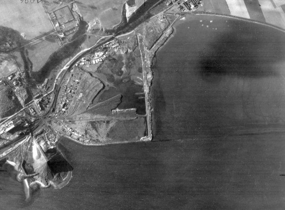
In 1989 the remaining lagoon of 68.7 acres (27.8 hectares) was declared to be a Site of Special Interest by the Secretary of State for Scotland by the Kinneil Lagoon Nature Conservation Order.
C: Kinneil Coal Co. – the Snab
In 1843 John Wilson of Dundyvan built four blast furnaces on the coast at Kinneil to exploit the local coal and iron reserves. The works were amongst the largest in Scotland and produced a vast quantity of waste and so from 1866 it was used to reclaim additional land to the east of a small promontory known as The Snab. Part of this, to the north-east, was used for a brickworks. The last blast took place in 1884, by which time somewhat over 50 acres had been created.
From 1927 the Kinneil Coal Coy was also engaged in reclamation work, tipping colliery redd daily to the east of the Furnaceyard Pit. The haulage road for tipping was situated high above water level, and the embankment was sufficiently strong to divert the tide, providing a receptacle for the silt. The company’s objective was a point opposite Bo’ness Distillery with the intention of providing sufficient additional land for the erection of coke ovens and distillation plant for residual products. The Kinneil Cannel and Coking Coal Co was a subsidiary of the Lochgelley Iron and Coal Co Ltd and it erected a hopper and chute to assist the operation.
D: Bo’ness Town Council – Snab to Bo’ness Station

When the Slamannan and Bo’ness Railway was constructed in 1849-51 Wilson of Dundyvan gave permission to use the waste slag from the Kinneil Ironworks free of charge in the embankments which ran along the coast. With the permission of the Duke of Hamilton a short heavy embankment was run across the former bay to the west of the Snab. Another longer embankment was needed from Kinneil Brickworks to Bo’ness Harbour, but here the Railway Company potentially had problems over the rights of the public. This bay fronted the old part of the burgh and the feuars had free use of the foreshore for their boats. Small piers or jetties projecting into the water and the “beach” formed a natural playground for the children. One member of the public suggested that the railway should be set on a viaduct whose arches would leave access to the shore. The Town Trustees and the Harbour Trustees were alive to the benefit of having the railway and, after consultation with the Admiralty, agreed certain terms. These are summed up in the report by Thomas Stevenson, (father of Robert Louis Stevenson) C.E., Edinburgh, for the Admiralty:
“The railway was to be carried on an embankment from the pier of Bo’ness harbour to the salt pond. This was a distance of 500 yards. Being generally about 100 feet seaward of high water mark the line would clearly be interposed between the shore and the sea. All access by the public to the shore for the purposes of walking, bathing, and drying clothes, and also for carts as hitherto, would thus be cut off. Beyond the site of the railway embankment the foreshore was flat and muddy, and there were one or more jetties there which would be cut off and rendered useless. It would be of little benefit to the inhabitants to have openings or archways under the railway, as immediately outside .of the embankment the foreshore was soft mud. The slip of land intervening between the railway and the embankment must be filled up, as otherwise it would become filthy and a nuisance to the town when no longer washed by the sea. Undoubtedly by the construction of the railway the public would be deprived of some advantages and of access to the sea heretofore enjoyed.
The Lords Commissioners of the Admiralty could therefore only treat this case in the same manner as a number of others of a like character, namely, that at the embankment, and between the railway and the sea wall for retaining the same, there be laid out and for ever maintained by the company a public way or walk, not less than 300 yards in length and not less than 12 feet wide; that three level crossings, or timber footway crossings, over the railway, not less than 6 feet high, be provided to give the public access to the public way at specified sites; that three flights of steps leading from the public way to the foot of the sea wall of the embankment be provided; and that the necessary culverts or drains across the railway be put in to keep the town dry or clean as heretofore. The parties having landing jetties on the line of the shore to be cut off would require to have others erected outside of the sea face of the railway embankment by the company, with access thereto across the railway. And, lastly, the arch already made under the railway near the salt pond would fall to be maintained by the railway company, along with a proper road leading to the same — a clear headway of 7 feet to be allowed under the arch”
(Salmon 1913, 273).
The promenade mentioned was constructed on the lines indicated as the property of the townspeople. The three level crossings were not a success, as they were frequently blocked by long trains of wagons and several accidents, some of them fatal, occurred, for which the railway company had to pay compensation. The inhabitants therefore were approached around 1870 by the North British Railway Company and it was agreed that in exchange for their rights and privileges the Town Trustees would receive £150 per annum for all time. So the town lost first its foreshore, and then its public promenade.
The 1920s saw a period of deep economic depression and in 1921 Bo’ness Town Council proposed two schemes to provide work for the unemployed of the locality. One was the construction of a coastal road from Bo’ness to South Queensferry, and the second was the reclamation of the foreshore or slobland within the bounds of the burgh to the west of the railway station to provide land for industry. Work would begin at the Kinneil Bing, which would supply the material for raising the surrounding level, and progress eastwards. Almost immediately the North British Railway Company objected on the grounds that it would lead to increased siltation at the harbour.
The Council pushed on with its discussions and in December 1921 the Duke of Hamilton indicated that he was willing to dispose of 124 acres of the foreshore to it. Before long it had acquired 135 acres from the Duke’s trustees. The Council wrote to the Board of Trade for help to fund the project as a means of relieving unemployment; and to the newly formed Forth Conservancy whose remit included land reclamation. The burgh surveyor estimated that it would cost £48,000 for 25 acres using the material from the pit bing. If they were able to get the materials direct from the pit, a saving would be effected as it was already loaded into wagons but, even at the lowest estimate, it would cost 1s per cubic yard for unloading. The expense would be at least £700 per acre, or about £100,000 in all. The costs of carrying the existing drains from the houses at Corbiehall out to low water-mark had to be added to this sum. Even with the assistance of the Government, the cost to the rate-payers was going to be very high. So, it was pointed out that a small area next to the high-water level might be filled up more cheaply, as the depth was less. Even the rent from this would not meet the costs for many years to come.
The lack of money remained a stumbling block, though it did not stop the councillors from discussing and promoting the project at length. At the end of 1923 a report by Leslie and Reid, civil engineers, Edinburgh, for the Work and Navigation Committee, noted that there were four separate schemes for reclamation between Bo’ness and Grangemouth. It suggested that the Bo’ness Town Council one should take priority due to the lack of flat land in the area and the demands of industry. It also recommended that the land should be handed over to the Forth Conservancy. The Conservancy Board was willing to take on the additional land. However, the Conservancy could not confirm that they would be able to reclaim the Council’s holding in a timely manner and soon had its hands full with its own scheme to the west at Kinneil Kerse. Yet more discussion ensued. Then, in July 1925 the Kinneil Coal Company bought several acres of the foreshore from the Council immediately to the east of the Furnaceyard Bing and started to undertake its own reclamation. Spreading the bing material exposed the coal still within it and many of the local unemployed flocked to the area to pick it.
Kinneil Colliery was also looking for somewhere to dump its waste. It was a tenant of the Duke of Hamilton’s Trustees, and so in 1926 the Town Council handed 14 acres of ground back to the Trustees for the use of railway sidings and further reclamation.

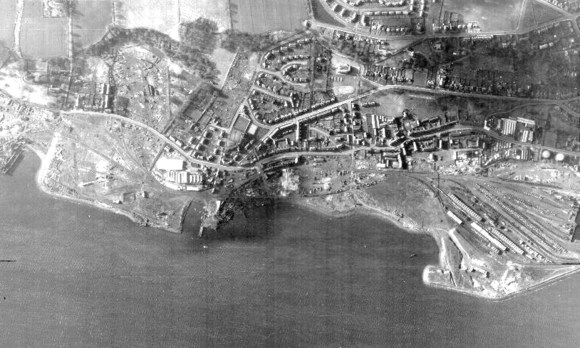
Bo’ness Town Council never had the funds to do anything with the sloblands. The western section of the lands were utilised for the new super pit at Kinneil which closed in 1982. Thereafter Falkirk Council started to slowly re-contour the vast area. The new landscaping presents more natural looking hills and tidal creeks and in 2013 this became Falkirk Council’s second Local Nature Reserve, stretching all of the way from Snab Lane in the west to Bo’ness Harbour in the east.
E: Bo’ness Dock
The 17th-19th century harbour at Bo’ness was tidal and vessels using it had to negotiate the mudflats. This was made even harder by the dumping overboard of ballast on their approach. Whilst this action meant that the ships did not sit as deep in the water, the jettisoned material accumulated and formed broad banks. Much of it was composed of flint, placed on board in the Thames estuary. Several Acts of the Scottish Parliament were passed forbidding the practice – the fact that they had to be repeated shows that they were of little avail. An area to the east of the main channel was allocated for the ballast and almost incidentally the land reclamation began.
Improvements were continually made to the harbour by building the west pier, extending it, and then building the east pier. One unforeseen consequence of this was increased siltation to the east and the level of the mud banks there rose. The businessmen in the town realised that this could be reclaimed and built upon to extend the urban area and the Duke of Hamilton was only too ready to give them permission so that he could gain a rent from the area. In the mid-18th century a local merchant, Charles Addison, had a sea wall of large ashlar stones built eastward from the East Pier and on the land he built Regent House, a large warehouse and a dwellinghouse. Regent House faced onto the Market Square and was used by the Customs service. The feu charter was granted by James, sixth Duke of Hamilton, on 20 September, 1752:
“Whereas Charles Addison, merchant in my burgh of Borrowstounness, hath already expended a considerable sum of his own proper money in gaining the area aftermentioned from off the sea (upon which there were never any house or houses built, and which never yielded any rent or profite to me or my predecessors), and in building a strong buttress or bullwork of hewen aceler fenced with many huge stones for the support thereof, and will be farder at a very great expence in building a dwelling-house, office houses, cellors, proper warehouses, and granaries on the said area or shoar of the said Burgh, which, works were undertaken and are carrying on by him upon the assurance of his obtaining from me a grant of the said area; Therefor and for his encouragement to compleat so laudable ane undertaking which tends to the advancement of the policy and trade of the said town,” and in consideration of his paying a yearly feu-duty and on several other terms and conditions, the reclaimed ground referred to was granted him. The boundaries, of the ground so feued are given as the sea on the north; the houses of Mary Wilson on the east; the High Street on the south; and the easter pier and highway leading to the same on the west”
(Salmon 1913, 250).
Land continued to be taken from the Forth in this area and it was here that the next major improvement for shipping was to take place in the form of a wet dock (see separate article). In preparation for this, a portion of the Grange foreshore adjoining the harbour was obtained by the Bo’ness Harbour Commissioners from William Cadell in 1878. The additional area was needed for the necessitous railway sidings. It was then made over to the North British Railway Company under the statutory powers acquired by the latter.
The North British Railway Company Bill of 1906 allowed it:
“To enter upon, take, and use for general purposes of their undertaking certain lands in the parish of Borrowstounness and Carriden… to the north and east of Bo’ness harbour, and situate between the company’s railway from Bo’ness to Bridgeness and low water-mark of ordinary spring tides.”
Although the Bo’ness Town Council was pleased that this would increase the rateable value, it was concerned that the work would impede the burgh’s drainage to the coast – sewage being dumped directly into the Forth. It also insisted that the railway crossings at Boundary Street and Man o’ War Street to the foreshore should be retained. The railway to Bridgeness had been made by Henry Cadell in 1878 to transport the coal from his pits to Bo’ness Harbour. He had always allowed the public to use the foreshore as they had rights to boating, bathing, fishing, and shooting there since time immemorial. Annual races had also been held on the foreshore. In the disposition in favour of the Railway Company Cadell had reserved to himself, his tenants, feuars, and vassals, access to the foreshore by the well-trodden paths.
The new reclamation by the North British Railway took the land down to the low-water mark extending east from the harbour entrance. The timing was fortuitous for extensive boring had indicated a coalfield of 900 or so acres in the area which would yield an estimated royalty of £4,000 a year to the Crown. In 1911 Charles E Allan of Belfast, trading as the Carriden Coal Company, obtained a lease from the Woods and Forests Department (representing the Crown). The lease embraced practically the whole of the sea coal out to the middle line of the Firth of Forth, and extending from a little east of Bo’ness Dock west beyond the River Avon. It was arranged to start working this from a new shaft located about 100 yards east of the easternmost end of Bo’ness Dock. The pit shaft was to be a little bit below water mark, and a formal application was made to the Board of Trade to reclaim a small part of the navigable river necessary for it. The sinking was done by means of cast-iron cylinders and this became the “Dock Pit.” The colliery required extensive railway sidings and so the coal company also acquired the Crown rights in the foreshore immediately adjoining. This was much further north than the reclamation done by H.M. Cadell and so he launched an objection on the grounds that it would cause additional silting at Bridgeness Harbour. For the same reason the Forth Shipbreaking Co. Ltd. also objected. Not only did the work continue but it was to extend even further eastwards. In 1933 the North British Railway Company decided to fill in the old timber basin to the south-east of the new dock to accommodate more railway sidings and this was completed in August 1934.
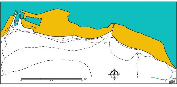
B – Bridgeness Tower;
C – Carriden Church;
P – salt pond.
The dotted line represents the probable Roman coastline.
F: Grange Estate – Boundary Street to Carriden House
In 1868 William Cadell bought 86 acres of foreshore at Grange from the Crown for £344 with the intention of reclaiming it using a wattle fence and the process of warping. He never got around to erecting the costly fence and contented himself with depositing colliery debris along the beach west of Bridgeness and round No.6 pit mouth. He also constructed a stone wall a little up from the low water line on the north side of No. 6 Pit. William died in 1888 and his son, Henry M Cadell, began the reclamation of the 25 acres of mud to the east by running a low bank from near the pit to the eastern boundary of the foreshore. The bank, about 3ft high and 300yds long, was completed by the end of 1890, and it formed a lagoon inside of which the mud began to silt up. The colliery redd had to be disposed of and was emptied out every day. By 1892 the mud inside the first low bank had silted up to the top of it. A second bank, about 4ft high, was therefore run out on the top of the first and at the east end it was turned 65 yards shorewards, so as to form a settling lagoon at a higher level. For this task large quantities of redd were available from No.6 & 9 Pits.
H.M.Cadell describes the process in some detail in “The Story of the Forth,” and it is worthwhile repeating it from his personal perspective:
“The idea of a dyke of stakes and wattles did not commend itself to me, as there was available plenty of heavy rubbish from the colliery situated near low water at the east side of Bridgeness harbour, and with this the embankments were all constructed. At first a low bank, the top of which was only 3 to 4 feet above the level of the mud on the landward side, was run round the lower part of the foreshore when the tide was out. The bank was about 20 feet broad on the top, sufficiently wide for a double line of 3 feet light railway. It was not long before the calm water inside the inclosure became silted up with soft mud to the level of the rails on the bank. A second low embankment was run round the enclosure on the top of the first, so as to cause a higher stratum of water to lie calm behind it, and in time this too became smothered on the landward side under the rapidly accumulating silt. At the end of 1900, ten years from the date of the completion of the first bank, the mud had risen 10 feet above all the lower part of the enclosure, and the surface of the intake was well above the level of high water of neap tides and only submerged about 4 feet at ordinary springs.
The progress of siltation will be apparent by reference to the accompanying diagrammatic section across the original foreshore and embankments at Bridgeness.
The embankments were made of loose stones, ashes, and ballast, quite porous and open. At first the impounded water ran through the barrier as through a sieve, and no attempt was made to render it watertight. But the water that issued at low tide on the seaward side was always observed to be quite clear, the mud having been all filtered out as it percolated through the barrier. The filter, however, before long became clogged up, and the interstices of the bank were entirely filled with plastic clay, so that it was converted into a kind of solid conglomerate as tight as a bottle. The ebbing tide no longer ran through it, but over the crest in a long thin cascade like the tidal waterfall at Connel Ferry on a very small scale.
After the enclosed mud had risen above high-water level of neap tides, the intake was surrounded by a third embankment about 6 feet high, which had to be made watertight to exclude the sea entirely. The sea was finally shut out in the beginning of 1901, about eleven years after the first embankment was begun. After the mud was dried up, it was partly sown down with grass. But here the agricultural part of the experiment suddenly ended. On the 28th October there was a great storm and an unusually high tide, and the sea burst through the bank at a weak place and flooded the whole enclosure. The gales lasted for about a fortnight, and on 28th November the storm reached its height, when it may be remembered, H.M. Revenue cutter “Active” was driven against Granton pier and totally wrecked, with a loss of twenty lives. The breach was not repaired for a long time, as the whole intake of some 30 acres was now so shallow that I found it could be raised above tide level by the ordinary process of dumping down rubbish and ashes, large quantities of which could be got from the N.B. Railway Coy for the emptying. A 6 or 8-ton truck can be emptied by an unskilled labourer for 1s, or at a rate of about 2d a ton, and a good worker can at this rate earn 5s or 6s a day quite easily. Almost the whole intake has now been thus filled up with railway ashes and colliery debris from the adjacent pits.”
In autumn 1900 H.M. Cadell began to construct a new wharf parallel to and in front of that of his father, extending further to the east. It was close to the water line to provide loading facilities for vessels taking the coal. It consisted of wooden piles 40ft long and 12ins square with the front sheet piled so that the bottom could be dredged. At the end of two years the mud in the enclosure had silted up 10 feet at the deepest place, or at the rate of one inch a month on the average. 2.75 acres at the south-west corner of the reclaimed land was feued to Robert Mickel & Co for a joinery and sawmill in 1902 and shortly afterwards the Northern Trading Co. let another 2.5 acres for a pit prop yard which subsequently expanded as land became available. At the same time W.R. Fairlie of Glasgow leased the west breakwater of Bridgeness Harbour and the land to the side of it to break up iron ships. This business did well and was later taken over by P & W McLellan Ltd. After 24 years work the whole of the 25 acres had been reclaimed and was occupied. Another pit prop business, that of James Kennedy & Co, took the last plot.
All of the Grange foreshore had by 1912 been filled up with colliery redd and to get rid of the daily quantity it had to be tipped on a high bing along the east side of the reclamation. This high bank could not be let for timber yards or any other business and was wasted ground of no use till levelled down. So, negotiations began with Rev William Dundas, the minister of Carriden, for the purchase of the 22 acres of the Glebe foreshore. After the Carriden Coal Co had abandoned its pit and small harbour there, the shaft had been filled up and the plant cleared off. A small bit of the ground round the pit head had been reclaimed but then lay derelict for a short time. With the sanction of the Court of Teinds, H.M. Cadell paid £2,600 for the Glebe foreshore in 1915, including any minerals that might still be left in it. It was more than it was intrinsically worth, but it gave the Bridgeness Coal Co. plenty of new ground for a colliery tip, which in turn made more new land. It also gave access to the Carriden Estate foreshore to the east, and opened up the way to the purchase of Carriden Estate itself. In April 1915 application was made to the Board of Trade for permission to reclaim 20 acres of the Carriden Glebe. The levelling up of the Glebe foreshore proceeded every year till it was all filled up except a bay left for shipbreaking purposes, and eventually most of it was let for a woodyard. The estate of Carriden was sold by Joseph Constant in November 1916 to the Bridgeness Coal Company which announced its intention to continue the reclamation as far east as Burnfoot.
G: Carriden Estate
To the east of the Carriden Glebe the coast projects slightly to the north and here there was a zone of erosion rather than deposition and so the sea dykes at Carriden were constructed to defend the existing land rather than to gain new land. The dyke was substantially constructed in the period 1819-1823 with large dressed sandstone blocks presenting a battered face to the waves. Robert Stevenson of lighthouse fame was the consulting engineer. As there was an existing right of way, a footpath was provided along the top of the dyke and set back from it was a tall estate wall. Measures were taken to prevent horsemen from using it (Hope Papers GD253).
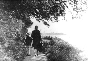
Over the decades the condition of this coastal path deteriorated and in the early 1980s it was replaced by one the landward side of the estate wall.
In 2015 Falkirk Council continued this path eastwards to Blackness, putting in concrete sea defences and creating a scenic cycle path. This involved negotiations with the riparian landowners with rights to the foreshore.
