The large barony of Manuel in Stirlingshire seems to have been created in the early 12th century and probably corresponded in area to that of the later parish of Muiravonside. Its centre must have been in the vicinity of Haining Castle on the main road from Edinburgh and Linlithgow to Falkirk and Stirling. Before long it was fragmented into smaller holdings. One of the first divisions was made around 1160 with the establishment of the priory of Manuel at the ford across the River Avon. The barony of Manuel-Foulis was independent by the fourteenth century, leaving the lands of Haining as a separate entity. Occasionally early documents refer to the barony of Manuel and that of Haining interchangeably, but this seems to have been a misunderstanding of the historical divisions. Indeed, the first time that Haining is referred to as a barony is in 1508, though it had evidently been so for some time.
Like all baronies its fortunes and extent varied over time. The principal owners of Haining are summarised in the following list:
| Pre 1417 | William Crawford |
| 1424 | Reginald Crawford (son) |
| c 1450 | Rankine Crawford (son?) |
| 1477 | Robert Crawford |
| 1498 | Archibald Crawford (son) |
| c 1538 | William (son) |
| c 1542 | in ward of Alexander Lord Livingston (brother-in-law) |
| 1546 | Agnes & Margaret Crawford (daughters) |
| 1556 | Agnes & Thomas Livingston |
| 1602 | Thomas Livingston (son) |
| 1604 | Alexander Livingston (son) |
| 1612 | bought by John Livingston |
| 1634-5 | held by creditors – David Hay & George Lord Forrester of Corstorphine |
| 1646 | James Livingston, Lord Almond |
| 1674 | Alexander Livingston (nephew) |
| 1685 | Alexander Livingston (son) |
| Alexander Livingston (son) | |
| 1695 | James Livingston |
| 1715 | sequestered by Government |
| 1720 | bought by York Buildings Company |
| 1783 | bought by William Forbes |
In 1417 William Crawford of Manuel received a charter of confirmation of a grant of lands in Airth. It remained in his family until c1542 when another William Crawford died leaving no male heir. His daughters, Agnes and Margaret were under-age and so the barony was administered by their uncle, Alexander, Lord Livingston. After coming of age Margaret sold her share to her sister and when Agnes died her husband, Thomas Livingston, inherited. His son seems to have become financially embarrassed and in 1612 Haining was acquired by John Livingston of Baldoran from a cadet family of the Kilsyth Livingstons. The behaviour of the new owner and his son of the same name was little short of scandalous and they too ran into financial difficulties. In 1634-5 the lands were in the hands of David Hay of Easter Kennet and then George Lord Forrester of Corstorphine, who may have been creditors of John Livingston. James Livingstone, Lord Almond, bought the barony and in 1646 received a charter from Charles I uniting all of his lands into the Regality of Callendar.
James Livingstone had been made Lord Almond in 1633 – the name was probably derived from his estates further east beside the River Almond. Not having any legal heirs his 1660 charter allowed his nephew, Alexander, to inherit. It would seem that Alexander, as heir apparent, moved into Haining Castle for in 1667 the minister of Muiravonside was presented by Alexander Livingstone of Almond. It was at this time that the name of the castle and barony were changed from Haining to Almond. In 1694 there is a reference to “Mains of Almond” and in 1722 to “Almond Wood” and the “barony of Almond” (Reid 1994, 22). Sibbald, in 1707, refers to “the Castle of Haining, now Almond House”. Due to the local pronunciation it was often abraded to “Amon.” In the chronological description that follows it will be referred to as Haining Castle until this period.
The nature of the first house at Haining is not known. The twelfth century dwelling is likely to have been of timber, perhaps with a surrounding defensive earthwork. The “moat” depicted on the 1860s Ordnance Survey maps could well date to this period. It is curiously egg-shaped with a slight kink in its south-west side which does not relate to the known later features. It occupied the top of a slight rise with the land falling away on the north, west and east sides to a small stream or drain (shown as a boundary wall on the OS map). The land, however, continues to rise to the south and Muiravonside Cemetery spreads out over a higher summit.
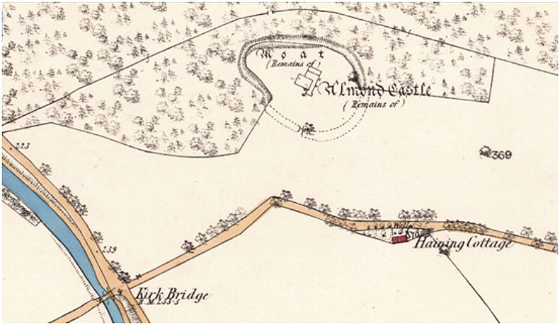
To the south of the castle was a public road, now only a right of way used by walkers. This was once a very busy and important route and when the Union canal was constructed the builders had to provide a bridge – the Kirk Bridge – for its users. To the south-west this road led to what became Parkhill House (sometimes also referred to as Haining, resulting in much confusion). Eastward it went to a ford across the River Avon just to the south of Manuel Priory and thence to Linlithgow. It will be seen from the map that there is a kink in the road just opposite to Haining Castle and from this an access road led to a bridge over the defensive ditch. Prior to the construction of the canal there was also a road north-west from this junction, skirting Haining Wood leading on to Nicolton and Falkirk.
The appellation of “moat” given to the surrounding ditch suggests that it may have held water and in the 1950s the RCAHMS surveyors did note a dry stream valley where the bridge stood, however by then the contours had already changed. It is possible that it may have been flooded, but this seems unlikely. A similar feature at the Grange in Zetland Park, Grangemouth, would naturally have filled with water due to the high water table there, and the same was probably true of the large ditch surrounding Callendar House.
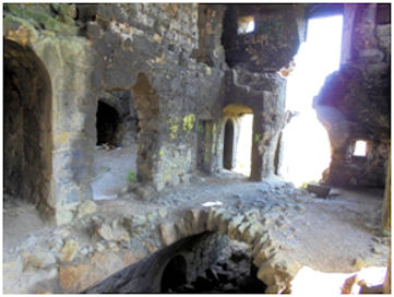
Illus 3: The Tower House looking north-east.
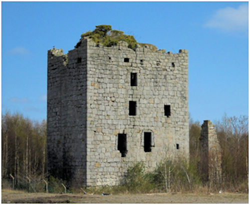
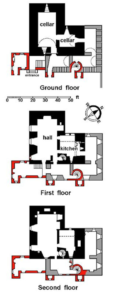
The stone castle at Haining can be dated on stylistic grounds to the early 15th century, though it is only in the following century that we get references to the “tower and fortalice” there and it is also referred to as the “manor place.” It must therefore have been built by the Crawford family. The castle was typically an L-shaped tower with its windowed long side aligned NW-SE – for ease of description this will be referred to as the south side in what follows, and the other sides are named in accordance.
Illus 4: Gargoyles with slits in the parapet above.
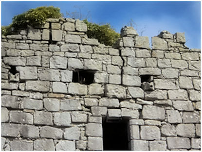
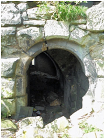
In most L-plan tower houses the main door is in the re-entrant angle, but that is not the case at Almond Castle. The entrances were in the centre of the east side. The main one was at first-floor level, but its external face and door checks were cut away by later alterations and a new lintel inserted. The original bar hole to secure the door in the closed position is still visible and on the south side its hollow extended at least as far as the secondary doorway. Immediately below this was the entrance to the basement with its double-splayed margins and a round head. An even larger bar hole is to be found here, together with fixing points for the door and a wrought iron yett.
Illus 5: The Entrance Doorway to the Basement
External 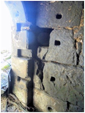
Internal with Bar Hole
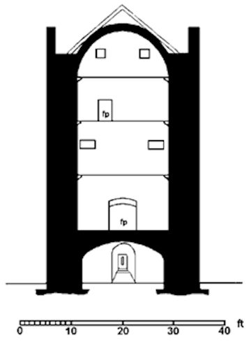
Illus 7: Section through the Main Block of the Tower House (after Hunter 1949).
Adjacent to the main entrance was a spiral stair which went to a caphouse on the battlements. Despite its position within the building, all of the doorways off it are onto the main block. The second floor would have held the laird’s private suite. At the south end of the east wall there is a piscina for a private chapel with a pointed arch and a drain at the back. There are three windows at this level and a large fireplace in the north wall. At the west end of the room are three wall lockers. The third floor and the garret were presumably used for bedrooms and the servants and the windows and fireplaces were correspondingly smaller.
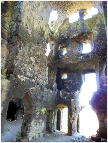
Illus 8: Two views of the Interior of the Tower House looking north-east to the main entrance.
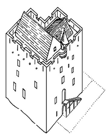
The overall plan of the castle bears a close resemblance to the tower at Dunnottar Castle which is known from documentary evidence to date to just before 1395. Combined with the masonry and treatment of the wall-head it suggests a date early in the 15th century for the construction of Almond Castle (SHR 1952, 194).
Illus 9: Reconstruction Drawing of the first phase at Almond Castle, c1450.
One oddity is the lack of gardrobe provision and waste material must have been carried out in containers; odd too that the ornate basement doorway must have been largely hidden by the external stair to the main door immediately above it. In any case, it was about to be cut into and completely hidden by the next major phase of expansion.
The rooms in the tower house were vast and lofty and access to the rooms in the wing was taken through those in the main block. To increase the accommodation and privacy a substantial three-storey lean-to structure was tacked onto the north side of the wing and wrapped around the east front as far as and covering the main entrance. Its southern limit stopped just shy of the basement slit and the two windows on the floors above.
The positioning was judicious. It did not block the larger windows on the south façade and provided a new more fitting entrance. The northern section did not intrude upon the shady re-entrant area but offered fine views to the Forth.
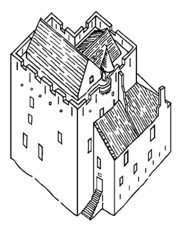
Illus 10: Conjectural Reconstruction of Phase 2 at Almond Castle, c1590.
The external walls of this phase average 4ft 6ins wide at the base, but like the tower may have thinned on the upper floors. The ground floor of the Phase 2 building was vaulted, reflecting that of the earlier building. These storerooms were ventilated by narrow slots which were parallel-sided and must have admitted little light. The basement room in front of the main entrance is 8ft 10ins wide internally and still retains much of its vault, but the remainder are barely perceptible. Archer’s drawing shows the vault on the north side, which was entered by a new doorway cut through the former window slot in the gable of the north wing.
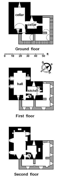
Illus 11: Plans of the Phase 2 Extension to the Tower House at Haining Castle. The original tower is shown in black, the extension in grey.
The plans of the upper floors are largely conjectural, though the detailed drawing published by Grose provides some evidence. It shows that the west gable, which was monopitched, was crowstepped and topped by a large intaken chimney stack that leant against the tower house. The north-east corner is not depicted with any form of skew which suggests that it had a hipped turn along the east side of the older building.
The roof raggle for the lean-to is still very evident, as are the joist holes for the floors which confirm that there were two levels and an attic above the cellars. On the first floor a doorway was cut through the back of the kitchen fireplace to provide access. The high quality of the interior of the extension can be judged from the fine curved stonework of a fireplace grafted onto the tower house wall at the west end of the north range. The buildings did not stand in isolation and in 1537 the tower, manor gardens, orchard and woods of Haining are mentioned.
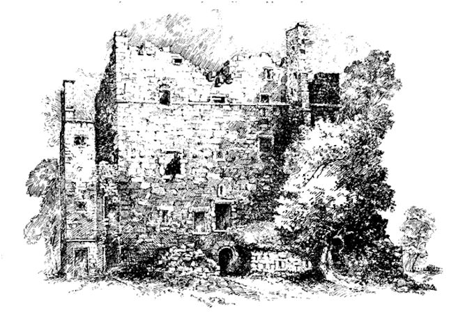
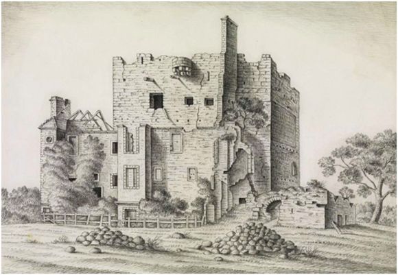
Illus 13: Haining Castle looking south showing the Phase 2 Extension in front of it. The building on the far left was Haining Cottage. Woodprint of 1790 for Grose.
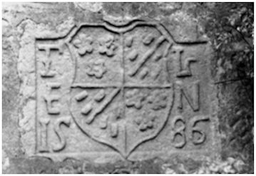
The date of the Phase 2 extension is not known, but the thickness of the walls and the extensive use of vaults point towards the 16th century. It may well have been built for Archibald Crawford who in 1499 was clawing back items that his father may have given to his sister before his death. However, it might date to later that century and it is possible that the armorial stone now at Gilmeadowland commemorated this phase and not, as is usually stated, the final phase. The shield is charged, for Livingstone: quarterly, 1st and 4th, three cinquefoils; 2nd and 3rd, a bend between six billets. The initials T L and E N, which flank the shield, are those of Thomas Livingstone of Almond, third son of Alexander, 5th Lord Livingstone , and his wife Elizabeth Nicholl, who were married before 1582. The stone measures only 0.60m by 0.43m and so it is unlikely that it was displayed above the first storey.
Illus 14: Plans showing the Phase 3 additions at Haining Castle in red.
The Phase 2 extension appears to have been very utilitarian. However, the main doorway where we might expect to find the greatest embellishment was swept away by the next major development. The reconstruction drawing shows a wide external stair on the site of that used in the next phase, but this is purely conjectural. Had the armorial stone been at or near this entrance it could have been moved to a more peripheral location where it would have been one of the first stones to have been taken away for reuse.
By contrast to the plain design of Almond the 1580s and 1590s saw an amazing flourishing of Renaissance architecture in Scotland. It produced the fantastic facetted façade of the courtyard at Crichton Castle and the ashlar courtyard and loggia at Castle Campbell. By the end of the century the building at Haining must have appeared somewhat antiquated. The old seats of power continued to be occupied and upgraded with Renaissance frontages grafted onto them and as late as 1636 the pedimented windowed façade of the courtyard at Caerlaverock Castle was created. When, around 1640, James Lord Almond acquired Haining Castle, he appears to have set about making it his principal seat and to this end the frontage was radically reshaped in the Renaissance style. Grose refers to this when he notes “a modern addition at the east end, seemingly of the time of Charles I or II.” The east wing of the Phase 2 extension was extended even further southwards and carried 14ft beyond the tower house. The walls were only 0.6m thick and were of coursed rubble in pink sandstone, except for the front east façade which was of polished ashlar. Here, at the southern corner, a slender square three-storey tower acted as sentinel to the main approach from the south over a new bridge. This turret had a doorway at ground level, with a moulded string course above, and a little above that was a small oval light with a rusticated surround, known as an oeil-de-boeuf. Below the moulded eaves course was a large round light. Clearly this front was meant to impress.
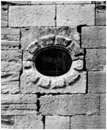
Illus 15: Rustic Light in the southernmost Turret.
Early drawings by Archer and the sketches by MacGibbon and Ross show a second turret grafted on to the corner of the previous vault. The vault was removed at this point and an entrance passage cut through to the original basement doorway. Archer’s drawing also shows a third turret, already in an advanced state of decay, half way along the frontage to the north of that and its footprint appears on the 1st edition OS map. It is indicated on MacGibbon and Ross’ plan as a short stub wall protruding from a spiral staircase. These three evenly-spaced turrets would break up this façade and dominate its appearance.
Each of the new turrets appears to have had a doorway on the ground floor; that of the third turret giving access to the spiral stair. That stairway was probably of an earlier date as its original ground-floor exit lay just to the south of the turret and was blocked off. However, it is interesting to note that the stair was hidden within the existing building rather than placed in a circular tower on the front as would usually have been the case. It was needed to provide better access to the rooms of the Phase 2 extension. The main entrance now lay between the first and second of the turrets and led to a broad stone scale-and-platt stair, the scar of the first-floor flight being visible on the front of the old tower.
Undoubtedly the grounds would have been laid out in a grand style to go with the new buildings. The approach-road over the landscaped old ditch, now much smaller, was crossed by a stone bridge 30ft to the south of the house. It consisted of a single segmental arch with a span of 10ft 10in, and a width of about 8ft. Photographs indicate a broad terrace in this area to the south of the tower and we might expect that the gardens mentioned in 1537 to be in this area. The “moat” would have been filled in along this stretch to facilitate this, as indicated on the OS map. Grose’s drawing shows trees on the northern slope which presumably represents the orchard. We can only speculate that the formal gardens now lay to the east of the house as shown in the reconstruction drawing.
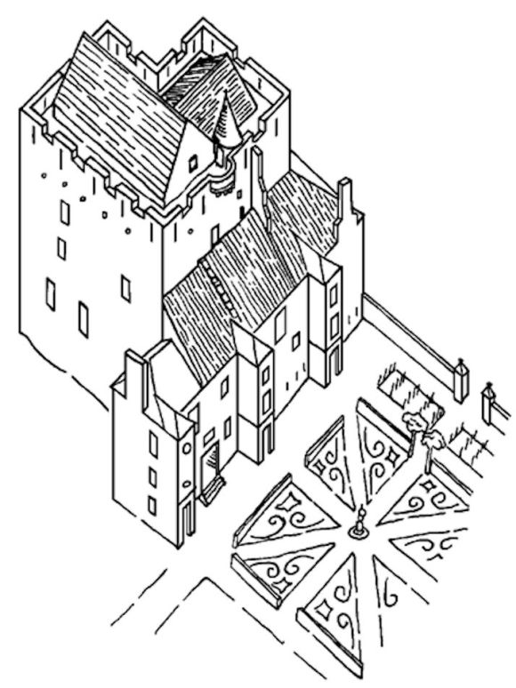
Illus 17: Reconstruction Drawing showing Almond Castle c1640.
James Livingstone served in the Dutch army and moved in high circles so it is possible that there were Continental influences in the architecture. He became involved in many of the series of turbulent national events that now took place. The next two decades were to be ones of unrest and confusion involving Covenanters, the English Commonwealth and the King. Details of these will not be given here. It was alleged that a conspiracy to arrest the Earl of Argyll and the Marquess of Hamilton, known to history as “The Incident,” was discussed in Livingstone’s house, and that he would have played a leading part in the arrests. However, the King and the Covenanters were close to an agreement and as part of the settlement Livingston was created Earl of Callendar on 6 October 1641.
In 1650 the Earl of Callendar supported Charles II but found it hard to play a part in the unfolding events. After the defeat of the Scottish army at Dunbar on 3 September 1650 Cromwell’s army moved slowly westward and halted for a while at Linlithgow. Haining Castle was occupied as an advanced post before the march westward was resumed. Musket shot marks by the slit window to the basement on the west side of the castle may belong to this period in its history, but the castle does not appear to have suffered any structural damage.
On the other hand Callendar House vigorously resisted the invading army and was taken by storm on 15 July 1651. It was badly damaged and may well have been deliberately slighted.
The Earl of Callendar spent much time and effort on trying to recover his estates and it was late in 1655 before it was discharged to him. When he returned to Callendar House it required much work and it is possible that he stayed at Almond Castle whilst repairs were undertaken. In the 1660s his nephew and heir, Alexander Livingstone, was at Almond. James Livingstone died in 1674 and Alexander moved to Callendar House. He died in 1685 and in 1689, a charter by Alexander, 3rd Earl of Callendar, was dated at Almond. In 1707 Robert Sibbald described Almond House as “a neat House with a Wood and fine Gardens about it” (Sibbald 1707, p.55). Thereafter Almond was little used and in 1715 the Livingstone family forfeited its estates for the last time.
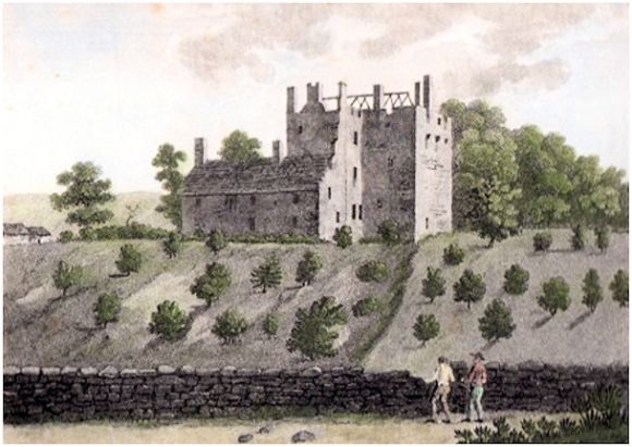
In 1720, the Callendar estates, including Almond, were acquired by the York Buildings Company, and in 1783 were purchased from it by William Forbes. Almond Castle no doubt entered on a period of decline after the fall of the Earls of Callendar and was let to tenants, probably becoming little more than a farmhouse. The sketch in Grose’s “Antiquities” shows it in 1790. The main block of the castle seems to be falling to ruin and the rafters on its roof were exposed. The tenant was living in the wing on its northern side. A passing note in a letter to William Forbes in 1793 mentions “4 Cairts to go to Almond Castle for tyles” (Forbes Papers 529/13). The tiles were probably being taken off the roof of the building for re-use elsewhere.
The castle must have finally ceased to be inhabited very shortly after this, for the old Statistical Account (1797) says that “there is an Old Castle called Almond hard by the Church which belongs to the Callendar estate, but is not now inhabited”. Around this time William Forbes consolidated the ruins of Manuel Priory which lies nearby as it was considered to be an important antiquity. He may well have left Almond Castle standing for the same reason.
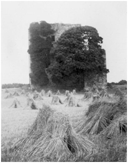
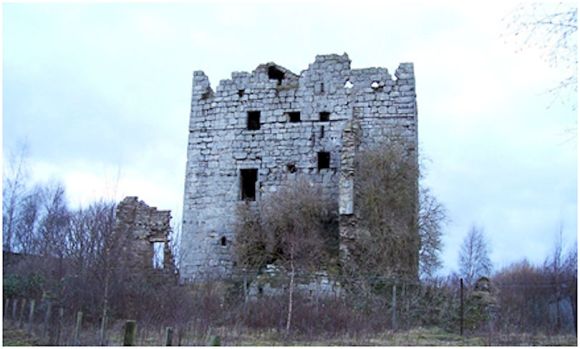
Illus 18: Almond Castle looking north, c1950.
In the 1880s, when MacGibbon and Ross visited, the castle stood in the middle of a cultivated field tenanted by Andrew Reid of Haining Valley Farm. Fleming provides the same information: “It stands on a solitary mound in a field of grain, the ancient approach, distinctly traced, being by a stone bridge over a now empty water course, which formerly was probably part of a surrounding moat.” Gillespie in 1879 was, as usual, more prosaic:
“[The Keep] is evidently fast falling into debris. Vegetation is everywhere forcing its way through the widening crevices of the disjointed stones; and that shattering process of itself will very soon lay what remains of the hoary peel-house in ruins. Yet the reader must not imagine that the old castle is now totally deserted. The very reverse, in fact, is the case. Leaf- hid in its ivy branches are some hundreds of chattering sparrows and finches; conies in flocks are continually feeding about the grassy foundations; and the cattle, too, fattening on the surrounding pasture, resort for shelter to its vaulted chambers.”
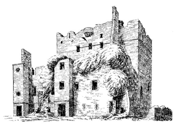
Thankfully antiquarians visited the castle from time to time to record it, including some of its features which have now been lost. The bartizan covering the early entrance is depicted on Archer’s drawing and that of MacGibbon and Ross. It is also rather vaguely shown on a drawing by a pupil from Blair Lodge School, executed during a school visit. It collapsed before 1921 (The Scotsman 4 July 1921, 6) and can no longer be made out. In 1938 Robert Hunter researched the history of Haining Castle and delivered a series of lectures on the subject in the area. He then set about raising awareness to raise funds for its preservation, but the war intervened. He published his research in 1949. After the war other forms of reconstruction took priority and in 1963 the Royal Commission on the Ancient and Historic Monuments of Scotland produced a full descriptive account of the castle using the dating established by Hunter. This dating differs from that given above in that he attributed the stone of 1586 to the third rather than the second phase.
Blair Lodge School was not the only one to visit. In August 1877 the Evangelical Union Sabbath School of Falkirk had an outing to the field beside Haining Castle. The adults explored the building whilst the children played in the adjacent field provided by Mr Reid. They arrived by a barge on the Union Canal which was used to convey them from the Glen Village. Other schools followed. Today the castle is widely advertised on social media for those seeking interesting places to visit whilst touring the canal – but it is in an advanced state of decay and over the last decade large amounts of masonry have been lost.
Illus 20: Manuel Brickworks with Almond Castle in 1980.
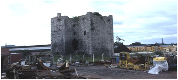
In 1923 Alan Stein sank a fireclay mine at Manuel and over the following years a massive brickworks was established adjacent to Almond castle. It was continuously expanded and eventually edged almost up to the castle. The land around the castle was extensively remodelled altering its setting from one of undulating arable fields to level industrial yards. For years the public right of way that skirted the castle provided many hazards to the walker. In the late 1960s Stein was taken over by General Refractories, and then by Hepworth Ceramic Holdings. After further takeovers it was closed in December 2001 and the site levelled. For a while it looked like a “sustainable village” with the castle as its focus would emerge from the debris, but it never got further than the planning stage. Meanwhile the old keep defies time, but without care it too will follow the same destiny as the brickworks.
Sites and Monuments Records
| Almond Castle (Haining Castle) | SMR 204 | NS 9566 7728 |
Bibliography
| Fleming, J.S. | 1902 | Ancient Castles and Mansions of the Stirling Nobility. |
| Grose | 1790 | Antiquities of Scotland |
| Hunter, R.L | 1949 | ‘‘Haining Castle.’ Proc Falkirk Archaeological & Natural History Soc, 4, 9-23. |
| Johnston of Kirkland | 1722 | Macfarlane’s Geographical Collection (Scottish History Society). |
| Kier, R. | 1827 | Falkirk Monthly Magazine. |
| Livingstone, E.B. | 1919 | The Livingstones of Callendar. |
| MacGibbon and Ross | 1887 | Castellated and Domestic Architecture of Scotland. Vol. 1. |
| RCAHMS | 1963 | Stirlingshire: An inventory of the ancient monuments. |
| Reid, J. | 1994 | ‘The Feudal Land Divisions of East Stirlingshire,’ Calatria 6, 79-110. |
| Reid, J. | 1994 | ‘The feudal land divisions of Muiravonside Parish: the principal subdivisions,’ Calatria 7, 21-85. |
| SHR | 1952 | Scottish Historical Review, Vol. 32. |
| Sibbald, R | 1707 | History and Description of Stirlingshire. |
G.B. Bailey (2020)
