The walk is just under 4 miles along the main road from Corbiehall to Bridgeness and returning via the residential Grange Terrace and Stewart Avenue where the Victorian merchants and manufacturers of Bo’ness built their fine houses well above the industrial bustle of the shore road below.
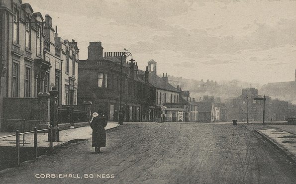
We begin in the car park at Corbiehall opposite the Parish Church sitting high up on Pan Brae. Between the car park and the road is the 19th century graveyard, though you would be forgiven for missing it. The stones were laid flat some years ago to make grass cutting easier and with neglect, weather and sinkage have made most indecipherable. The graves are mostly those of victims of the cholera and typhoid epidemics that hit the town from the mid-century on. Not far away is the spot where five witches and a warlock called John Craw were strangled and burned at the stake in 1679.
Moving along the road towards the town proper we note the nicely restored house with its forestair and a tenement building dating from 1905 with a plaque commemorating the Sea Box Society which was founded in 1634 as a kind of insurance society for sea captains. A little further along the south side of Corbiehall is the old Star Cinema which was originally the Parish Church of Bo’ness built with money from the Sea Box Society in 1638. It was much changed over the years and served as an Episcopal Church for a period after the new Parish Church was built on Pan Brae in 1888. Behind it is the surviving graveyard which we will visit on our way back.
Ahead of us beyond the roundabout we can see the first of a group of buildings which survive near the Ness where the harbour was built in the 17th century. This is the five storey Granary building dating from the early 19th century. It was converted into flats some years ago. Following the road round on the seaward side we cross the remains of the elevated waggon way constructed in 1772 by Dr Roebuck of Carron fame to carry coal from the higher ground to the south of the town down Church Wynd and along the shore to the west pier. From here we can see the so called ‘Tobacco’ warehouse dating from 1772. This four-storey building with its round oculus windows may indeed have stored colonial tobacco for a few years before the American War of Independence disrupted the supplies. Not far away at the mouth of Scotland’s Close, once the High Street of the town, stands the old west pier tavern now part of the Bo’ness Library. Nearby are the beautifully restored Dymock’s Buildings parts of which date to the 1700s. At the end of Scotland’s Close we reach the heart of the old town with interesting buildings all round like the Bo’ness Journal office (1887) on its tight gusset site and with a fine candle snuffer roof. Across the road is the Anchor Tavern built in 1891. Not far away is the splendid Hippodrome Theatre designed by Matthew Steele in 1911 and due for restoration in the very near future. We move along North Street past where the tall town hall clock tower used to dominate the scene. It was demolished in the 1960s, a fate which had befallen the town hall itself in the late 19th century.
We now return to the seaward side along East Pier Street and Union Street, passing the Customs House on the left. On the other side of the railway line lies the surviving dock which we can see from the bridge at the Scottish Railway Preservation Society centre which lies in front of us. We will have a better view of the dock later in the walk when we climb up higher! From here we walk via Dock Street back to the main road which take us into what remains of industrial Bo’ness. There were several foundries in the town and one survives, Ballantines, on a large and dilapidated looking site on the south side of the road. It is certainly the last of its kind, the last foundry in the whole of Falkirk district.
We pass on our left the cumbling building in Boundary Street which was built in the mid 19th century as the Free Church and later served as a reading room provided by Henry M Cadell of Grange for the working men of the town and still later as the Bo’ness United Social Club. It sat on Boundary Street because it was intended to serve the Free Kirkers of both Bo’ness and Carriden Parish. [This building was demolished in 2006]. We are now in the area known as Grangepans, a reminder that the area once had a big salt making business. They last made salt here in 1889. Here too was the famous Bridgeness Pottery run by the McNay family until the end of the 19th century, and the shipbreaking yard of P. and W. McLellan.
We can see Bridgeness Tower ahead of us as we pass the road end of Cowdenhill Road and arrive at Bridgeness. Now comes the hard bit!. We are going to climb up Harbour Road which is both steep and quite long. Before we do so though we can look at the reproduction of the inscription of the famous Bridgeness distance slab discovered near here in 1868. It tells us that the Second Legion “Augustus’s own” executed the work (presumably the Wall) for 4652 paces. That is about the distance from Carriden to Inveravon.
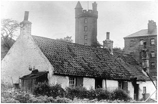
Bridgeness Tower is on our right. It was once a windmill built around 1750 and converted into a tower house by Cadell of Grange in 1895. It was once used as an astronomical observation centre and had the most powerful telescope in Scotland at the time, or so it was said! . We now climb up passed the Bowling Green where Bronze Age kist burials were unearthed in 1896. On our left is Kinningars Park with its capped coal shaft and the remnants of a colliery winding house used later as a dovecot for new Grange House.
The last part of the climb is the worst but the views make it all worthwhile. Turning at Grange Loan – its all downhill now – we pass Carndene House on our right and approach the Grange School not far from the site of the original 16th century Grange House. We can admire the handsome houses along Grange Terrace with the little Victoria Park on our right. The Church ahead is St. Andrews, built in the early 1900s to replace the Free Church in Boundary Street below. One house to look out for is Rondebush the home of merchant John Cochrane who returned from South Africa to run the family engineering business and the Sea Box Society.
We continue along Stewart Avenue from where we can see the docks more clearly, and pass Matthew Steele’s strangely shaped Masonic Lodge built in 1909. Further along on the right are the remains of two church buildings which served several different congregations at different times, particularly the Catholic community. On the left is the Glebe Park with the striking Town Hall which opened its doors in 1904. The curved section at the end housed the Carnegie Library.
We now pass the war memorial down a flight of steps into Church Wynd which descends to Corbiehall and divides the old churchyard into two sections. This happened in the 18th century when the Hamilton family of Kinneil House required the town to provide them with a high and dry road to the church rather than the often flooded coastal route! We can visit the lower churchyard from Corbiehall and see the many stones bearing the signs of maritime and mercantile activity.
We are now back on the main road and a retrace our steps back to the car park to the west.
Ian Scott (2005)
