Excavations in 2025
Introduction
In 2020 a trench (E on illus 1) was excavated across the line of the Rampart of the Antonine Wall at 72 Grahamsdyke Street, Laurieston (Romankiewicz 2022). To the south of the Rampart a turf stack had been piled above a shallow ditch partially filled with stones. Little of this feature was available for examination at the time but it clearly headed southwards.
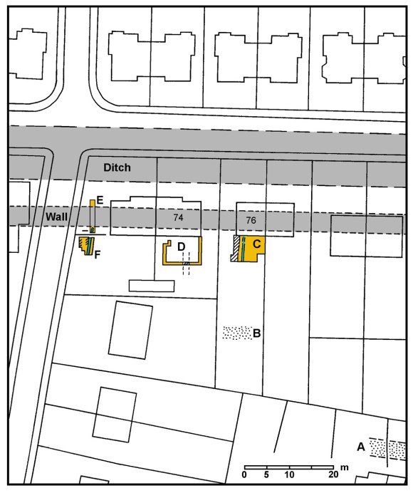
A – Road discovered in 1967; B – Road observed in 2000; C -Excavation in 2008; D – Excavation in 2011; E – 2020 Excavation; F – 2025.
Excavation
In March 2025 an opportunity arose to examine the area to the south of Trench E (at NS 9135 7952) in advance of the landscaping of the area. Trench F was excavated over the period 14-16 March, just to the south of a brick wall which divides the property. It was limited on the west by the wall bounding Dundas Road; and on the east by the lower level terracing associated with the extension to 72 Grahamsdyke Street carried out in 2019 (Bailey 2021, 370-371). Southwards the area was required for the storage of soil during the excavation.
As usual for this area, under the topsoil (F2) there was a post-medieval plough soil (F3) consisting of brown-orange clay loam with a maximum depth of 0.2m. It contained fragments of pantile, 19th century clay tobacco pipes and oxidised green-glazed ware. F3 sealed a lower plough soil of orange-brown sandy clay loam (F4) which was largely devoid of finds and merged into mottled grey and orange brown sandy loam (F6). F6 produced six sherds of Roman pottery, spread throughout the trench. Its appearance suggests that it was composed of decayed turf. At this level a series of N/S features was revealed. The main one was a band of orange-brown silty loam almost 1m broad (F7) with patches of broken sandstone along its central spine (F5).
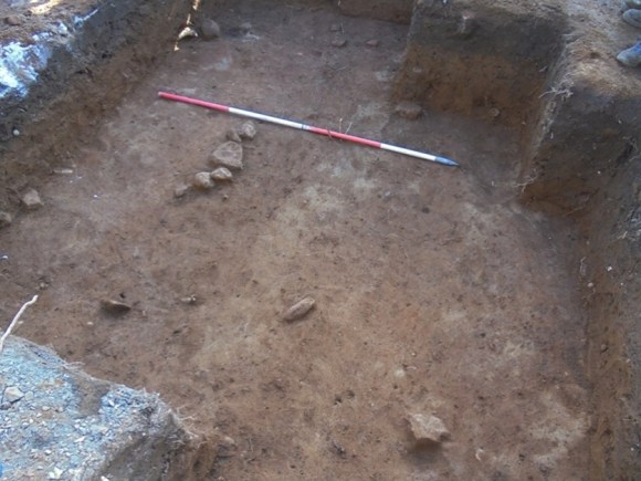
To its east was F6; and along its west side a narrow band of patchy cream and grey silty clay signifying laid turf (F11). F11 was up to 0.2m broad and was bordered on its west by another band of F6. The last 0.2m or so of the trench was occupied by patches of cream silty clay (F10) which along the western baulk showed very strongly.
The stones of F5 rested on the upper fill of F7 which upon excavation proved to be a drain/gulley averaging 0.94m wide and 0.3m deep. Its sides were relatively steep with a flat base which had been cut into the natural orange gravel. The lower fills were of gravel, washed from the lower sides, and silty material from the upper sides – indicating that it had been left open and weathered.
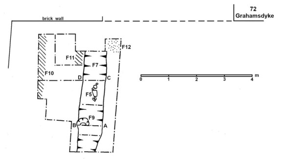
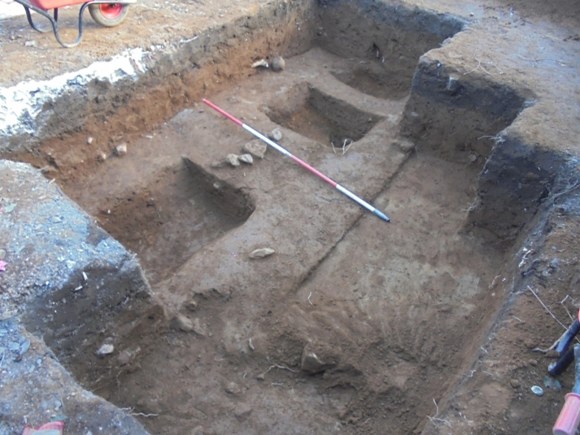
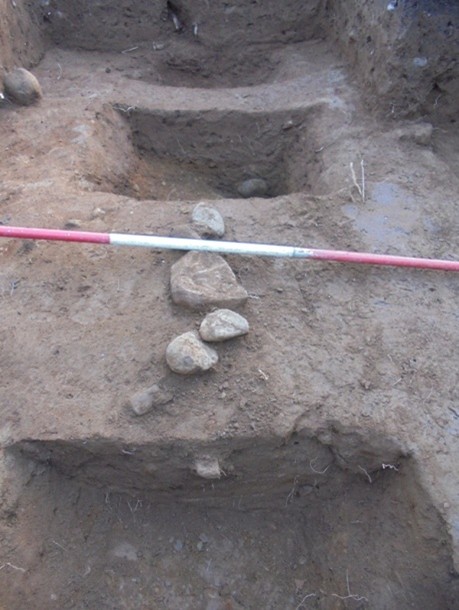
Cut into the base of F7 on its western side was a possible post-hole (F9). Its dark gritty fill was a sharp contrast to the natural orange gavel. This material did not extend into F7 and so it is not possible to say if it was cut by the gulley, or if the post had been removed before the gulley was filled.
Finds
| REF. No. | CONTEXT | DESCRIPTION | PERIOD |
|---|---|---|---|
| 1* | F2 | 1 body sherd from the shoulder of a greyware jar with ext. groove. | Roman |
| 2 | F3 | 3 plain stem sherds from a clay tobacco pipe 19th century. | Modern |
| 3* | F3 | 1 small body sherd of black-burnished ware. | Roman |
| 4* | F3 | 2 small base sherd with foot-ring in oxidised green-glazed ware. | Post-Med |
| 5 | F3 | 1 small piece of a pantile. | Post-Med |
| 6 | F3 | 2 burnt sherd from a thin-walled glass vessel | Post-Med |
| 7* | F6 | 1 tiny fragment from a mortarium in white fabric with large angular dark brown trituration grits | Roman |
| 8* | F6 | 1 small base & 3 small body sherds of black-burnished ware. | Roman |
| 9* | F6 | 1 body sherd from a greyware jar. | Roman |
| 10* | F7 | 2 medium-sized & 2 small body sherd from a burnt greyware jar. | Roman |
| 11* | F7 | 1 small body sherd in black-burnished ware. | Roman |
| 12* | F7 | 2 wrought iron nails with square shanks – one of with a round head. | Roman |
Interpretation
The site at 72 Grahamsdyke Street is the third to explore the area immediately to the south of the Antonine Wall in this vicinity. Previous work at 74 and 76 Grahamsdyke Street found turf dykes and a similar drainage gulley (Bailey 2021, 367-371) on much the same alignment as the features excavated in 2025, as well as an occupation level. Just as importantly. Roman pottery was also found in association with them, and a Roman shoe was found at 72 Grahamsdyke Street in 2019. Further east, at 104 and 132 Grahamsdyke Street (Bailey 2021, 355-361) hard trampled occupation levels with post-holes and pottery were disclosed. This suggests that the area between the Antonine Rampart and the Military Way, all of the way from the west annexe of the fort at Mumrills to at least 72 Grahamsdyke Street, some 240m, was divided into small plots which contained structures.
These structures included gulley drains which stopped just shy of the Antonine Rampart. We now know that that at 72 Grahamsdyke Street did not enter a culvert through the Wall on the same alignment and we must assume that they joined a cross gulley behind the Wall in order to coalesce and seek out such culverts. This indicates that they were laid out after the construction of the linear barrier. The use of upcast material from the digging of these drains, and of turf banking, along their upper edges, may have been to cope with the quantity of water that they had to deal with during heavy rains.
Set a little way to the west of the gullies at both 72 and 76 Grahamsdyke Street were laid turf structures which ran parallel to them for at least 5m from the Wall. That at 76 seemed to be turning to the west at that point and it is possible that rather than representing turf boundary dykes these were parts of lean-to structures attached to the back of the Wall.
The nature of the occupation is difficult to determine but the presence of so much material culture suggests that it was more than mere cultivated allotments. The nearest archaeological parallel comes from Housesteads on Hadrian’s Wall where the small fields tucked into the shadow of the Wall to the west of the fort are just part of a system that covers a wide area (e.g. Crow 1995). The fields there date to the whole period of the Roman occupation and underwent many modifications. Unfortunately, archaeological excavation at Housesteads has been rather limited. Closer to hand are the small enclosures surrounded by earth and turf dykes at Rough Castle which lie to the south-east of the fort there, served by a bypass road (Mate 1995). The regular layout at Mumrills might suggest some form of centuriation, undertaken shortly after the construction of the Wall. The question as to whether this occupation was military or civilian is perhaps irrelevant, as many of the occupants of a vicus would have been retired soldiers (Watson 1969, 152). Here one is reminded of the field systems to the east of the fort at Carriden from where an altar dedicated by the vikani was retrieved (Richmond & Steer 1957).
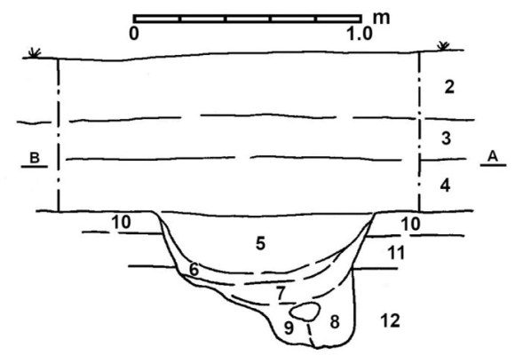
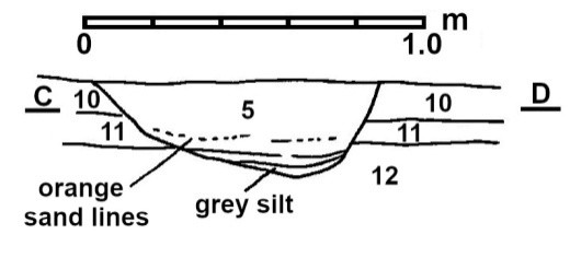
The gulley (F7) was open long enough for the sides to erode and for a thin layer of silt to form. The main fill (layer 5 illus 6 & 7) was of orange-brown silty loam which did not show any signs of containing decayed turf. This is a little surprising as it might have been expected that so close to the Rampart of the Antonine Wall there would be some collapsed material from it. The fill hints that the gulley may have been deliberately backfilled and then a line of small stones (F5) was set along its centre. They were not laid flat and most resemble the fill of a rumble drain. It is therefore possible that the base of the drain had been deliberately raised in height in order to allow it to crest the stub of the demolished Rampart. This would be a surprising act as it would indicate that the occupation, or at least the line of the drain, continued even after the departure of the Roman army.
Contexts
2 – black humic loam – topsoil
3 – brown-orange clay loam below topsoil and above F4 – post-medieval cultivation soil.
4 – orange-brown sandy clay loam – late medieval cultivation soil.
5 – Broken sandstone forming the centre line on top of F7.
6 – Horizontal layer of mottled grey and orange brown sandy loam below F4, cut by F7.
7 – N/S ditch/drain (for fills see sections) – Roman boundary drain.
8 – purple-brown clay loam below F6 and above natural orange gravel – Iron Age cultivation soil.
9 – possible post-hole in west side of F7 filled with dark grey and brown grit.
10 – linear patch of laid turf (cream silty clay) along the west side of the trench) – turf boundary dyke.
11 – patch of cream and grey silty clay (laid turf) along west side of F7 in north of trench – banking of ditch.
12 – patch of orange gravel in north-east corner of trench – redeposited natural.
Bibliography
| Bailey, G.B. | 2021 | The Antonine Wall in Falkirk District. |
| Crow, J. | 1995 | Housesteads: a fort and garrison on Hadrian’s Wall. |
| Mate, I.D. | 1995 | ‘Excavations of an enclosure system at Rough Castle, Falkirk,’ Proc Soc Antiq Scot, 125 (1995), 483-498. |
| Richmond & Steer, K.A. | 1957 | ‘Castellum Veluniate and civilians on a Roman frontier,’ Proc Soc Antiq Scot, 90 (1957), 1-6. |
| Romankiewicz, T, et al | 2022 | ‘Another Wall of Turf: Geoarchaeological sampling of the Antonine Wall at 72 Grahamsdyke Street, Laurieston, Falkirk,’ Proc Soc Antiq Scotland, 2022 (151, 103-141). |
| Watsin, G.R, | 1969 | The Roman Soldier. |
Acknowledgements
The author would like to thank Mr & Mrs Barker for their permission to undertake the work and for their interest and help during the excavation. Light work was made of the digging by the large number of people who came along to lend a hand – Alan Calder, Emma Gillanders, Richard Gillanders, Nicola Hamilton, Ian Hawkins, Bruce Harvey, Alasdair Kane, Janet Kinninburgh, Ian McAdams, Donald McLeish, Kenny McLeish, Andrew Packman, Nelly & Hugh Trapp.
