The broad bay between Elphinstone Pans (modern Dunmore) and Higgins’ Neuck provided a sheltered anchorage for ships and it is not surprising that the associated settlement at Airth became one of the first burghs in Scotland. Trade at the port must have been brisk and as a consequence the parish church in the 13th century was one of the most ornate. The harbour acted as the staple port for the royal burgh of Stirling and supporting infrastructure was put in place, such as yards for repairing and maintaining ships. At the centre of the bay there was a slight peninsula created as a result of sedimentation along the east side of the Airth Pow which issued across the mudflats at that point. This protruding spur was quite low but acted as a natural jetty. To reach it, the ships, which were relatively small and of shallow draft, had to follow the channel formed by the pow across the mudflats. As the incoming tide of the Forth was stronger than the outgoing one this channel had a tendency to veer to the north and it was a feudal obligation of the tenants in the area to dig it out when required – usually once a year.
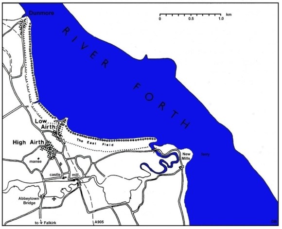
The bay with its extensive stretch of mudflats in shallow sheltered water was ideal for the reclamation of land. Just how early this began is uncertain but by 1689 a long narrow strip had been taken from the Forth along this entire stretch of coast. To the east of the Cobbletree Goat as far as the Pow Burn at Higgins’ Neuck this belonged to the owners of Airth Castle, and to the west to Dunmore estate. This meant that the cost was split, making the task more manageable. Initially this dual control was not a problem as the two estates progressed the work in tandem. By the time that they were out of step the understanding of sea dyke construction had advanced and so coordination was not as important.
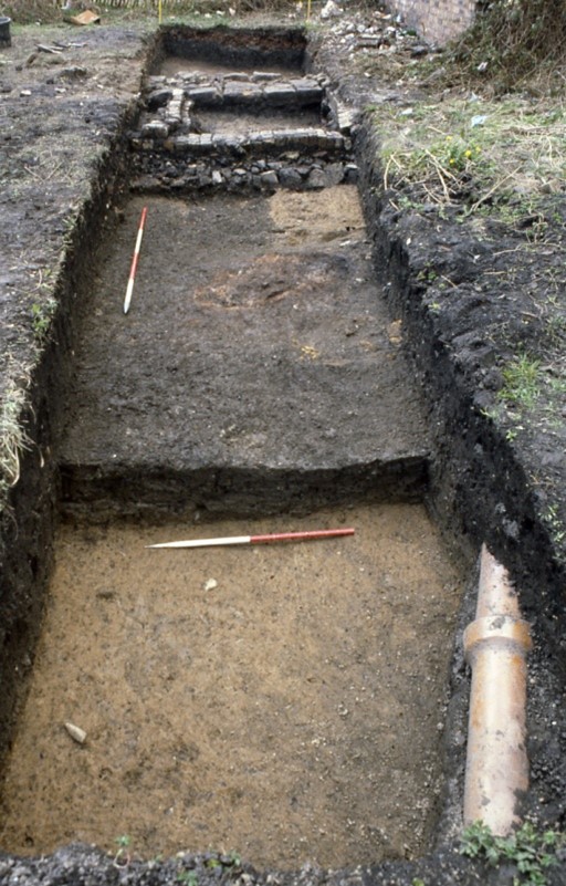
The medieval settlement had been located on the top of the Hill of Airth, a little to the north of the castle for security. It was here that the warehouses were located and to which the goods had to be carried. By the mid-17th century conditions were peaceful enough to allow a drift of the population down to the landing place and this was formalised in 1697 by the erection of a new mercat cross there in the centre of a market place. On the north side of this square a two-storey house was erected shortly after 1700 and remained until the 1970s when it was demolished. It was to be over twenty years before this central site was built upon and in 1989 the author conducted an archaeological dig there. Almost immediately behind the house, just 35 yards from the mercat cross, the edge of the warping was encountered. This had been the coastline in the medieval period.
A map originally surveyed on 19 February 1810 by the Falkirk land surveyor John Shaw shows the positions of the sea embankments of 1726, 1780, 1795, 1802 and 1814 (Shaw 1810). Behind the 1726 and 1780 embankments Shaw’s map shows an earlier bank which fronts the “East Field” and lies landward of “The Greens,” both of which are obviously earlier reclamations. Between the East Field and the 1780 line a small, almost triangular area to the east of the northern part of Shore Road (where the ‘Herring House’ of 1711 was located) represents an intermediate stage in land utilisation and acquirement. A similar boundary south of this, on the west side of the East Field, probably reflects an earlier arrangement of this kind. The archaeological excavation showed that the point from which the reclamations began was only a matter of yards from the High Street. The date at which this area was reclaimed can only be hinted at by a large piece of green-glazed pottery found on top of the natural and below 0.5m of warped silt. It could have been in use in the sixteenth or seventeenth centuries. We may take it that the East Field was reclaimed in the seventeenth century, and that the original coastline would have approximated to the dotted line shown on the map below.
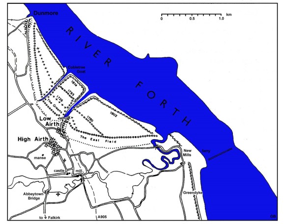
The dyke marked on the plan east of the Pow Burn as dating to 1780 was actually built for the Grahams of Airth Castle the following year. A copy of the successful bid is preserved:
24 Oct 1781. “I hereby make you an offer to build or make a sea dyke at Airth Green of the following dimensions; twenty two feet wide at the bottom, seven feet & a half high & two feet broad at the top of said sea dyke, and what sluices you may put in said dyke, you are to be at the expence, And for finishing of said sea dyke you are to paye the sum of one hundred & five pounds sterling, to be paid at different times to carry on the work, you accepting of this offer in writing will be binding on me” John Allan, Dunmore Harbour.
A minor problem arose that November when Robert Adam claimed a right of pasturage there, indicating that the land was salt marsh or sea greens. The dyke was constructed by John Allan, John Anderson, John Buchan and James Bauchop, and was examined in 1783 to consider its state of repair as per the maintenance contract. The storms that winter were severe and in 1784 when that contract was up for renewal it was pointed out that the Grahams “had proof of the dykes sufficiency the bypast winter” and were therefore urged not to insist on too harsh terms when considering the next maintenance contract as the sea could be very powerful.
The stormy weather was one thing, but defeating abnormally high tides was another. It was soon recognised that the dyke would need to be raised in height:
5 Sep 1783. “We John Espie & James Cowbrough being called as arbitrators on the sufficiency of the sea dyke built by John Allan Buchan & Co And by our judgement & that of Robt Inglis in Kincardine whom we chose as Oversman between us & our judgement is that it will cost £15.15 to make a sufficient dyke at the height it now is. And we recommend to Mr Graham to employ the same men to repair that dyke who built it if he is pleased to accept”
The reclaimed land was soon let:
4 Mar 1784. W. Graham “To Alexander Cummin, William Boyd & Jean Archibald Tenants in Airth… I likewise set to you the salt Greens of Airth inclosed by me containing twenty seven acres two roods & ten falls or thereby and that for Crop 1700 eighty four for which you are to pay me thirty pounds stirg for said crop by equall proportion … and I hereby reserve to myself the sea dyke from Montgomeries House to the eastfield with the ditch in the inside of sd sea dyke, you may cut the grass of the sea dyke but not pasture it with cattle and as I am to uphold the sea dyke I likewise reserve a liberty of taking feall & divot of any part of the said Greens hereby set to you (doing as little damage as possible) with roads to go to & carry of the same for repairing the dyke. I likewise reserve roads to carry of the brush stobbs & c allready lying on the Greens & to lay down brush stobbs & c within twenty yards of all the seaward marches bordering on said Greens with free ish & entry to bring or carry off the same at pleasure and I grant you my power of poinding any cattle found on the sea dyke or the Greens belonging to me beyond or without the sea dyke … you must look to the sluices as I cannot be answerable for any damage done by their being left open…”
This dyke was still giving problems in 1787 because it was too low;
“I am sorry for the fresh failure of the sea dyke. I am afraid from the tides getting so frequently over it, that it has been from the beginning considerably lower built than it ought to have been. As you know the tenant added to it’s height the other year. It therefore occurs to me that the partial repairs hitherto made are ineffectual, and to go on longer in that sparing way, would be like a farmer who bestows but half manure and culture on his fields – by which both outlay & labour is lost & the farmer at last begger’d. Whereas if the outlay of six years had been properly bestowed in the half of that space; everything in all probability would have prospered. We must now ascertain what height the sea dike ought to be so as to surmount the highest tide that has been known, even when enforced by an easterly wind, which I suppose was the case last week, and get it made & compleated of sufficient dimensions to that height at once. Till this be done I foresee neither master or tenant will succeed, and it’s a job of too great magnitude for any tenant to defray at the rent the greens are sett. But when once put in the condition required I apprehend any tenant can keep the dikes in repair.”
February 1788 (Airth Papers).
The estimated cost of the work was put at £30, to recoup which James Burn, the agricultural tenant “will pay 5 percent interest of additional rent on the outlay”. John Graham and William Whitehead put in estimates for the work, as did the Buchan family and some associated labourers. The bid of Buchan and partners was preferred because they were living on the estate. The specification was simple –
“I suppose the additional thickness is to be made on the outerside of the dike, and to consist of 4 feet wide at the base with a gradual intack to the top, & an additional height of 18 inches covered with green turf, and to be two feet wide at top.”
In 1792 the Graham Trustees considered an offer by Alexander Cumming for the lease of both the old and new salt greens (that is the 1726 and 1780 enclosures). The rent was to include the cost of erecting a new sea dyke to enclose yet more ground, as already proposed. The offer was deferred for a year so that more information could be gathered on the best line for the new sea dyke, taking into account such items as the tides. In 1793 a new sea dyke was constructed on the west side of Airth Pow by two sets of contractors, James Williamson and John Buchan and Partners. They were paid in instalments during the progress of the work, Williamson receiving a total of £40 and Buchan & Co £107. This is the dyke marked 1795 on the plan and in 1797 it was arranged that it would be “sodded” to raise it from time to time. In 1802 a contract was signed with John Clerk and John Campbell for building yet another sea dyke to gain 70 acres of salt green to the east of Airth Pow at a cost of over £1,140. Cuttings from the hedges on the estate were used in the sea dyke.
As each tier of sea dyke came into play the old ones were levelled to maximise the usable land. James Jardine, civil engineer, Edinburgh was brought in to report on the effects that the reclamations had in contributing to the silting up of the harbour. In March 1823 he noted that:
“The sea embankments on each side of the harbour and Pow, shelter the tidal waters, and enable them to deposit more mud than they would have done in their original exposed situation.… the dykes along the sides of the Pow, and the continual retreat of the sea, operate more powerfully now than formerly in silting up the Pow and harbour.”
At least the mud dredged from the Pow could be used in the reclamations.
The later sea dykes had to be of greater dimensions than their predecessors and the design changed with a tendency to reduce the angle of slope of the faces, particularly that facing the water. This trend can clearly be seen in the following two quotes given 32 years apart, in 1778 and 1810.
1778 – John Anderson and John Allan & Co, Dunmore Parks. “estimate sea dyke 21 ft at base 7 ft high 2 ft at top @ 2/- per running yd. estimate sea dyke 24 ft at base 8 ft high 2.5 ft at top @ 2/6 per running yd. level the ground & to stand all the damages by weather & tide.”
1810 – “Estimate for building a Sea Dyke upon the Estate of Airth, immediately to the southward of Dunmore March, for Thomas Graham Stirling Esquire of Airth of the following dimensions:
Front Dyke, to be 46 feet wide at the base, 4 feet wide at the top, and 10 feet in height. The sea side slope to be 2 ½ feet for every foot in perpendicular height; and the land side slope 1 ½ feet for every foot in height.
Side Dyke, to be 26 feet at the base at the upper end, 3 feet at the top, and 8 feet in height, increasing the dimensions in gradual proportion until it joins the Front Dyke.
The earth of the Front Dyke to be lifted from the outside, and the earth for the Side Dyke to be taken from the inside.
Whatever tunnels may be wanted, to be furnished by the proprietor.
Subsisting money to be advanced to pay the workmen at the end of every fourteen days.
The whole of the outside of the Front Dyke to be covered to the top with green turf, and the side dyke as far as necessary.
I, the subscriber, hereby engage to finish the whole of said dyke in a sufficient and workmanlike manner, agreeable to the above dimensions, as follows – the Front Dyke at eighteen shillings Sterling for each lineal yard; and the Side Dyke at twelve shillings Sterling per lineal yard. In witness whereof I have subscribed the above at Airth this 27th day of July 1810 years. John Cowie.”
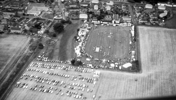
Illus: Aerial view of Airth looking south. The dark band of ground to the left of the park at Airth shows the location of the old harbour – now landlocked. The Airth Highland Games are in progress.
Writing in 1793 Rev Robert Ure stated that the extensive trade which Airth had enjoyed prior to 1745 had considerably declined due to the action of the government forces against the Jacobites that year. This had included the burning of two vessels being built on the stocks there. In fact, the harbour had become unusable due to the additional siltation caused by the reclamations, and, whilst the harbour at Airth was getting worse those at Carronshore and Grangemouth were improved.
