The mudflats or sleeches on the south side of the Forth were at their widest in the vicinity of Grangemouth and it is therefore not surprising that there are hints of early sea defences and possibly land reclamation there. In the 12th and 13th centuries a number of saltpans were gifted to Scottish abbeys by the Crown – the suggestion being that they were already established production centres and that the length of coast between the rivers Carron and Avon was particularly favourable for the extraction of salt. The salt production sites are reflected in such place names as Panstead, Saltcoats, Saltcotts, Overton of Saltcoats (for a greater range of such names in this area see Reid 2009, 279). The pans must have stood on the contemporary coast and any ancillary dwellings would not have been far away. These early saltmaking sites were connected by a road which ran along their southern sides and probably represents the dry ground just beyond the high tidal level. The road may have lain on a defensive sea bank. Such a slight bank is indicated by the name of “Candie” (meaning bank, slope, edge or border – ibid, 41), and “Powdrake” (meaning a bridge over a stream, ibid 86). By the late eighteenth century these were farmsteadings and many of them became prefixed with “Wester” because in the interim an “Easter” steading had been created nearer to the new coastline.
Roy’s Great Map, surveyed in the 1750s, clearly shows a sea dyke stretching all of the way from the River Carron to the River Avon. This line was essentially still the coast in 1860 when the first Ordnance Survey map was produced – except where the Grangemouth Dock Improvement scheme had distorted the situation on the east bank of the Carron in the period from 1840 onwards. An intermediary sea dyke may be hinted at by the name “Awalls,” also known as “Old Walls,” with a short length of road to either side mirroring the coast. The term “Old” is, of course, relative, and “Old Yards” to its south-east would have been a later enclosure – the latter being old in 1755 and the former even older.
A disposition of 1744 refers to the Wester Dykelands of Heuk and 6 acres of Saltcoats surrounded by a water-dyke. In a 1760 tack for Powdrake the landlord engaged to provide stones which the tenant was to cart and use “to defend the sea-dykes” (Harrison 1996).

The work undertaken by the Forth and Clyde Canal Company in constructing a new wet dock at the eastern terminal of the canal is detailed elsewhere (Bailey 2023b). As also is that on the two massive embankments (Bailey 2023a). These latter structures projected across the mudflats as an aid to shipping entering the new port facilities. They were a major engineering feat and cost in the region of £10,000 to build – a major investment! Thomas Wilson, who managed the project, was not surprisingly irate when he discovered that the Earl of Zetland was charging the Canal Company rent for the land that they occupied at the same rate as dry land. In his diary he dryly notes that
“But [of] all the circumstance connected with the Transactions, that of demanding a rent for the formation of the Embankments which have cost the Company nearly Ten Thousand Pounds and acquired to the Earl of Zetland several Acres of Land, that he should demand a Rent for the ground occupied by the Embankments is the most preposterous”
(Wilson’s Log 26 January 1844).

The Earl’s reclaimed lands referred to by Wilson lay to either side of the River Carron and in forming them he was able to make use of the Canal Company’s river embankments. The intake of land was gradual and new sea dykes were periodically erected to increase the landholding. In 1844 Wilson refers to land already reclaimed to the south of the river which appears in his 1851 entries as the saltings called Panstead Greens. The south river embankment was raised to ensure that this area was no longer subject to seasonal floods and the 1854 map of the port of Grangemouth shows its top to be 4ft above high water of spring tides. In 1851 another dyke was built to the east to take in another 14 acres. Mud dredged from the approaches to the harbour was dumped, with some difficulty, in this vicinity. On 3 February 1852 a very high tide flowed over the bank and flooded the new enclosure. The south side of the bank had been scoured by the flood water and the Canal Company re-faced it with turf (Wilson’s Log). Attention then turned to the sleeches north of the river and on 7 July 1853 Wilson wrote:
“went across the Carron and up the north side where the men employed by Earl Zetland are at work raising the banks. Mr Milne got the loan of the plan from John Smith, the Person who has charge of the men, so as to see that part of the bank east from the Coal Wharf which the Company have to raise.”
One can only assume that the Earl of Zetland was no longer charging the Canal Company rent for its banks which now formed an essential part of his reclamation schemes. This may not have been the first attempt to reclaim this area, for in 1812 Graham tells us that
“Wherever, on the other hand, these embankments are neglected, the sea is gradually gaining upon the land, and washing off the most valuable soil; a striking instance of which was observed to the north of the confluence of the Carron”.
(Graham 1812)
Even after 1853 the area seems to have been subject to periodic inundation and the 1854 plan shows that the embankment along the north side of the river was 3ft under the high-water level of spring tides.

The Caledonian Railway Company acquired the existing docks at Grangemouth in 1867 and ten years later started a huge programme of expansion. On 3 June 1882 the new Carron Dock of 19.5 acres was officially opened. It had been dredged out of the mudflats and the mud was used to reclaim a further 40 acres for railway sidings and other facilities. The Carron Dock opened onto the river Carron further down than the old entrance. To avoid the non-ending and annoying dredging of the river Carron it was decided to create a second wet dock between the Carron Dock and the Forth itself. This was the Grange Dock which opened on 10 October 1906, with yet more land. This time Dutch Blowers were used for the dredging operations, sucking the mud out of the basin and blowing it onto the reclaimed land which extended well out into the estuary. The additional area covered some 260 acres (Porteous 1994; Summers 2009).
During the First World War the Docks were closed to commercial traffic but the site witnessed much frenetic activity connected with the war effort. By the summer of 1917 some 31 acres to the west of the Grange Dock were acquired by the Admiralty and six large sheds were erected thereon for use as a mine depot, together with the necessary railway lines to service them. About 85,000 tons of slag and ashes were required to bring the land up to the required level. The sheds were ready for use in April 1918 and the Northern Barrage was laid from here.
In 1923 Scottish Oils began to construct the oil refinery at Grangemouth on a large-scale. It acquired existing agricultural land for this purpose and laid out a grid pattern of streets which it named after the farms and the activities of the old Grangemouth Artillery Volunteers – Tenacres Road, Saltcoats Road, Overton Road, Main Road, Candie Road, Old Refinery Road, Beach Road, Avon Road, Bearcroft Road, Range Road, Oldwalls Road, Rifle Road, Gunner Road, Target Road and Battery Road. Contrary to popular belief, the refinery did not reclaim much land from the Forth.
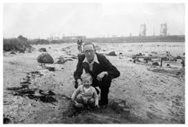
Up until the late 1960s the local youth had access to an area of the foreshore on the east side of the canalised Grange Burn known as the “Shelly Bank.” This was essentially still part of the 1860 coastline, but has since been reclaimed and the beach lost. It is now in the restricted area due to security requirements, meaning that the 75 acre salt marsh beyond the old beach is a haven for wildlife.