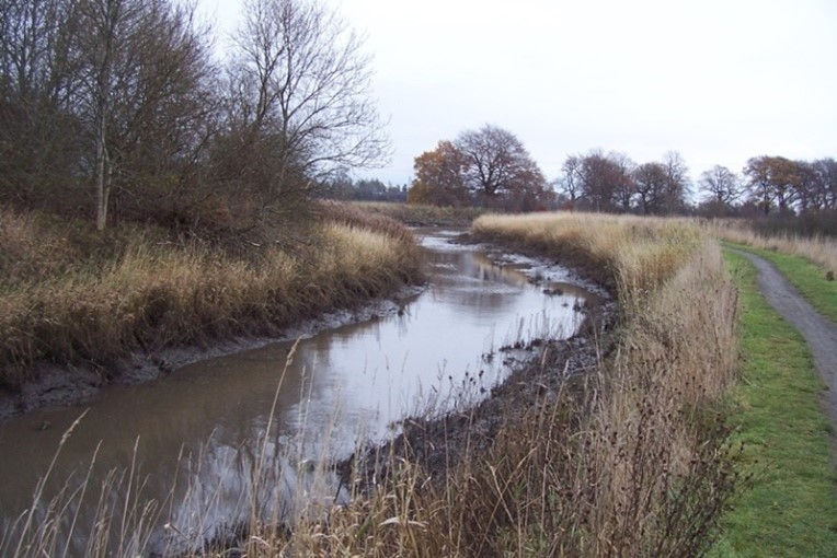
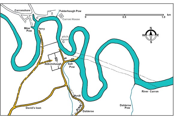
The Salt Pow issues into the River Carron at Abbotshaugh a little to the east of Bainsford. It has its rise in Callendar Park as the East Burn of Falkirk and gathers water en route to become a substantial waterway. At its mouth, prior to 1760, the river swelled in width forming a natural anchorage for ships. The river is tidal at this point and so salt water does enter the Salt Pow, but that is also true of all of the pows up to Carron and so it is unlikely to account for the name. It is therefore probable that the name is derived from the use of the pow as a port at an early date for the importation of salt manufactured along the Forth Estuary (Reid 2009, 169).
By the end of the 16th century the Salt Pow was Falkirk’s legal staple port – it being the point on the river nearest to the fledgling town. A charter given to the Earl of Callendar in 1643 refers to letters of 1590 from James VI granting his grandfather
“authority to excavate a pow or water passage upon the water of Carron through the lands of Dalderse then pertaining to Lord Salton or other lands adjacent to the said watercast for transporting coal to the sea from the coalworks of Falkirk, with power to construct a dam and sluice for the retention of water in said passage”
(quoted in Reid 1996, 89).
The intention was evidently to widen and deepen the natural mouth of the pow to accommodate the ships. The river had broad sloping sides of mud which would have made it difficult to load the coal. The main purpose of the harbour was therefore to provide suitable wharves so that the vessels could be loaded directly. At low tide they would have rested on the basal mud. However, if left unattended the mud would return on the incoming tides and so it was necessary to provide a reservoir of water with a sluicing arrangement so that the basin could be scoured at low tide. This was the purpose of the dam and sluice mentioned in the 1590 letters. They are referred to again in a charter of 1646:
“with the whole liberties and privileges of a harbour and station for ships upon the lands of Dalderse, or upon any other lands whatsoever, belonging in property or tenantry to the foresaid Alexander Lord Levingston of Almond, lying contiguous to the water of Carron, for the transporting of coals to the sea, from the said Lords’ coal-works of Falkirk, for the use and advantage of our subjects and others thither repairing; with power to make and erect sufficient bulwarks, The Damnes and Clauses for retaining the water in the passages and ditches of and from the foresaid river, within bounds, and for levying and exacting the whole anchorage duty of the shores, the rents, small customs, privileges and casualties belonging to a free port, from all ships, boats, and cruives calling or lying there, or entering any of the passages or pows leading through the foresaid lands in and to the said water of Carron; and to raise and build a station for ships or harbour, within any part of the said bounds, together with the privilege of appointing a ferry-man for the transportation of passengers from one side to the other of the said water of Carron, in whatsoever place or places within the said lands which may be most convenient for this purpose, to uplift the whole emoluments and advantages of the same, and to apply them to the personal use of the said Alexander Lord Livingston of Almond and his foresaids…”
(quoted in Keir, R 1827, 146).
In exercise of these rights the Earl of Callendar issued a directive in the Baron Court on 2 December 1651:
“It is statute and Intymate That quhatsoever persone or persones salhappine To bring in any victual tymber or any uther sort of mertchandwair to the schoir at Dalders or Salt pow That they pey anchorage and Custowmes for the sameine According as the sameine is peyit and exactit at uther stapill portis”
(Hunter 1991, 250).
The harbour of Falkirk was evidently important to the Livingstones of Callendar and when granting a charter of the Lands of Abbotshaugh in 1669 they reserved to themselves the
“libertie and priviledge to big and make harbories and powis upon any pairt of the said lands lyand neirest the sea ffor keiping of shipes barkes cre[ar]s quhilk sall hapin resort thairto ffor transporting or inbringing of coalls or victuall with frie ische and entrie thairto ffor horse and carts and lykways with libertie to make stethes at the seasyde for keiping of coalls thairintill”
The word straithes may indicate a bunker, though the more common term for that was a coal fauld, or a wooden pier with an adjustable ramp for loading the coal into the holds of the vessels at different states of the tide (Carron Co used the latter at Carronshore). The port was evidently busy for in 1718 James Galbraith of Dalderse was paid £6.13.4 for collecting the anchorage and shore dues. It was not just coal being handled and in 1723 Johnston of Kirkland describing Falkirk mentions that
“A mile almost north of this town is a Pow in Carron called the salt Pow near to Abbotshaugh, where the merchants unload their goods and carried them to this place.”
Roy’s map of 1750 shows a warehouse on the northern bank of the pow and just behind that the 1860 Ordnance Survey map has a row of single-storey cottages which were evidently built in the 18th century.
John M’Leish was employed as the shore master at the Salt Pow in 1760 and stated that
“from the said year 1740, a good deal of victual has been in use to be livered at Saltpow belonging to the estate of Abbotshaugh, on which the Lord Boyd has a coal-road, leading to the shore, and uplifts the shore-dues payable there; that the deponent is employed at present to lift these shore dues, and pays what he gathers in to Mr Pringle factor on the estate of Callendar; and that the shore-dues payable is one shilling Sterling for each hundred bolls of victual, but no anchorage.”
(Dundas Papers).
Before 1740 the coal was taken in sacks upon horses’ backs from the pits in Callendar Wood to the Salt Pow.
At that time there were only six carts in the whole of the town! The number of carts available for the coalworks slowly increased and from about 1740-45 they were employed on Lord Boyd’s coal road – David’s Loan. In the winter, however, that road was often impassable and the carts would be diverted to the Cobble Brae at Bainsford. This brae was also known as “Boat Sunk” – sunk being Scots for a bank. Edward McKenzie, carter in Falkirk, was paid by Lord Kilmarnock to drive coals to Cobble Brae for sea sale. There were at least 30 cartloads daily. Each cart could make two trips during short winter days and three in the longer summer days. Six carts made a chalder of coals (the Perth chalder was 5 tons, the River Forth chalder 30 cwts i.e. 1.5 tons; the Hurlet chalder 2 tons). We are likely to be dealing with the Forth chalder, meaning that 30 cartloads weighed in at 45 tons. It was shipped on board small sloops which were “loaded with as much as they could swim with” and then hauled from Cobble Brae to the Salt Pow to be filled up. James Forbes was told in 1784 that the previous year Boyd had sent 10,000 tons of great coals to sea, (Forbes Papers) which is consistent with the earlier quantities. Bark from Callendar Wood was also exported. Incoming cargoes at the Cobble Brae included peat and limestone for which small sloops without decks were used when the tide was suitable.
The roads were slowly improved and tolls levied. From the Salt Pow the road ran westward along Mungalhead Road to Tophill before continuing through Camelon – thus bypassing the town of Falkirk. In 1752 a turnpike gate and tollhouse were erected at Tophill in order to “levie toll from those who carry victuall from the Saltpow at Abbotshaugh to Cumbernauld.”
Up until about 1755 the corn trade at the Salt Pow was greater than that at Carronshore but a cessation of investment at the Salt Pow coincided with the development of Carronshore and it strode ahead.
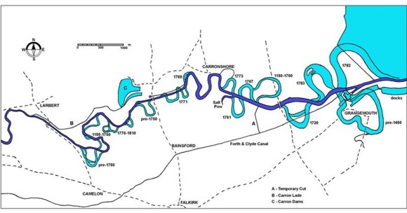
Nevertheless, Samuel Garbett & Co took a lease of the Salt Pow in 1765 in order to secure a monopoly of the trade on the River Carron. Having closed down all possible alternatives, it was able to state forcefully that Carron harbour and Salt Pow were the only handling places on the river (Caledonian Mercury 28 August 1765, 4). In 1761 Carron Company had cut the large loop of the river to the south and east of the Salt Pow making it easier to navigate to it. It would have been at this time that a second much larger granary was built to the north of the existing one. It was a substantial three-storey stone building with a pantile roof and faced onto the river.
Between 1764 and 1773 Charles Gascoigne then cut the loops to the north-west and north-east, considerably easing the journey to Carronshore, which was then given priority.
The Salt Pow then seems to have been sub-leased to Robert Cowan, a successful merchant in Bo’ness with interests in Glasgow. It was presumably in connection with the latter that he took the lease as it provided him with a shorter overland journey for his goods. He appears to have constructed a third granary with its gable directly on to the river (the original granary was redundant by this time). A strong wooden wharf was also built on the bank of the Carron to enable ships of large burden to moor – the entrance to the Salt Pow having been made tortuous by the straightening of the river.
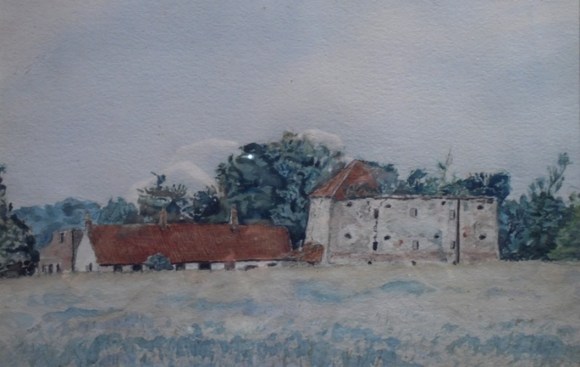
To the west he built a commodious and elegant house which is depicted on Grassom’s map of 1817 as a genteel mansion. The first floor consisted of a large parlour, two bed rooms, and a dressing closet, with a large kitchen; the second, of a large dining room, drawing room, and two bed rooms, with dressing closets; the third of four bed rooms, two lumber rooms, and garrets above. Adjoining to the house were two wings; in the one a large library, dressing room, closets, store room, and outer cellar; in the other, a large wine cellar fitted with catacombs, a larder, a servants’ hall, milk-house, and so on. The offices consisted of a coach-house, stable, and byre, washing-house, and laundry with several out-houses and shades, and sundry other conveniences. Three small enclosures were planted with trees and shrubbery. There were also two gardens, one of which was enclosed with a high brick wall, and well stocked with fruit-trees (Caledonian Mercury 11 July 1789, 1).
Around 1778 Robert Brown took over the lease. He had made his money as a merchant at Alloa before moving briefly to Carronshore. He was one of the owners of the newly established Sealock Shipping Company based in Grangemouth, but it did not thrive and on 3 May 1785 his business and personal estates were sequestrated. His furniture and library at Carronbank were sold off. Also to be sold or let were the two large granaries or warehouses capable of containing about 1500 bolls of grain. At the time Robert Brown had 360 bolls of barley and 150 bolls of oats there.
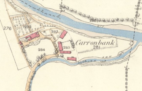
On John Anslie’s map of the River Carron (RHP 242) dating to 1797, the garden to the north of the house and the jetty (wharf) are annotated as possessed by Captain Craeford.
The buildings were then leased separately. The house was rented on an annual basis and the walled garden became a market garden. The house still belonged to the Carron Company and so it was soon used to accommodate some of its higher-ranking officials. George Rankin was the manager of the Company’s wharves at Carronbank and Grangemouth and naturally he stayed there for a number of years. After some fifty years in this post he retired and moved to Govan where he died in 1850. Carronbank was then occupied by William Johnston, the Company’s mining engineer. He moved to Fife in 1867, having lived at Carronbank for 18 years. His parents continued to live on at the house; his father, George, dying there in 1872 and his mother, Isabella Higgins, in 1877. From 1897 John C Brodie & Sons, the solicitors for Carron Company, oversaw renting out the house.
The 1913 Ordnance Survey map shows that the northern granary had been demolished by then and the southern one no longer had most of its roof. The roofed section was used for the storage of ice imported to the wharf from Scandinavia. It was demolished around 1942 along with Carronbank House. The area was planted with trees as part of the Langlees Community Woodland in the 1990s. The remains of the wooden supports for the wharf can still be seen.
Sites and Monuments Record
| Salt Pow Harbour | SMR 657 | NS 898 824 |
| Carronbank | SMR 1350 | NS 897 825 |
Bibliography
| Bailey, G.B. | 1992 | ‘Along and Across the River Carron: a history of communications on the lower reaches of the River Carron,’ Calatria 2, 49-85. |
| Hunter, D.M. (ed) | 1991 | The Court Book of the Barony and Regality of Falkirk and Callendar, Volume 1 1638-1656. Stair Society. |
| Keir, R. | 1827 | “History of Falkirk” in The Falkirk Monthly Magazine. |
| Reid, J. | 1996 | ‘Scotland’s earliest canal?’ Calatria 10, 85-92. |
| Reid, J. | 2009 | The Place Names of Falkirk and East Stirlingshire. |
