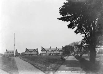
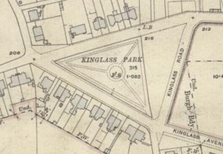
The slag heap at Chance Pit on the south side of Dean Road was acquired by Bo’ness Town Council and levelled at the beginning of the 20th century. Large quantities of soil removed from the widening of the Coach Road were used to surface it in 1909. The following year a park was laid out on the site and a privet hedge and shrubs planted. A hollow steel ship’s mast was acquired from the shipbreaking yard at Bridgeness and used as a flagstaff set in a central roundel. Ash paths radiated from this to meet perimeter paths. The park was named after the pit and was officially opened in August 1910. The area of the park was triangular and was bounded on each side by a road. The road on the south side was widened at the same time as the park was developed and within a year the side opposite to the park was feued to numerous people to build houses on.
There was also a football pitch in the area known as Chance Park and so when Henry Cadell pointed out in 1911 that the public park should properly be called Kinglass Park, which was the old name for the area, it was changed.

The north/south road, Kinglass Road, on the east side of the park was diverted to run in a more easterly direction on a prominent causeway. The 0.94 acre piece of land between it and the park was then gifted by Henry Cadell to the Town and was grassed over for children to play on. In 1920 this extension was filled up with waste material from Erngath Quarry to bring it up to the same level as the rest of the park and landscaped.
During the Second World War a static water tank was placed in the park.
National Grid Reference
NT 003 811
