SMR 77 / NS 9610 7635
These kilns were situated at a wharf on the west bank of the Union Canal at the Almond Ironworks. They are shown on the 1860s Ordnance Survey map with a railway running to them. Limestone was quarried in the parish and brought to the works by boat. It was reduced in the kilns for use as a flux in the blast furnaces which produced pig iron.
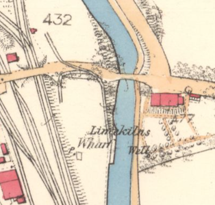
The ironworks opened in 1854 and we can be sure that that was when the limekilns were constructed. The works closed in 1881 and so it is not surprising that the limekilns were gone by the time of the 1897 edition Ordnance Survey map.
Bibliography
| Bailey, G.B. | 1992 | ‘Lime and limekilns in the Falkirk District.’ Calatria 3, 63-88. |
