SMR 1207 / NS 8545 7267
The water mill at Slamannan lay on the north side of the Kirk or Culloch Burn 750m to the south-west of the parish church. Here Roy on his map of c1755 shows a small community called Gateside signifying a road junction (Forrest in 1806 called it Balcastle Village). The main road from Avonbridge used to pass beside Balquhatstone House and on to a ford next to the mill before continuing west to Gateside, Southfield and onwards.
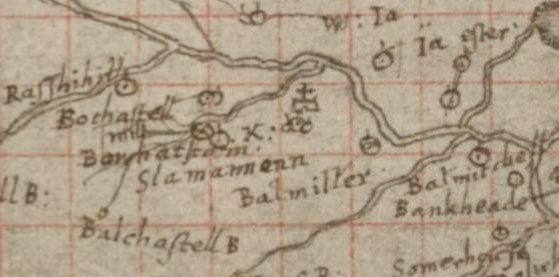
The land ownership of the Slamannan Parish was complex with three feudal superiors – all of whom had rights of patronage of the church and the sucken and multures of the mills. Their lands were interspersed and as a consequence there were at least two baronial mills in the parish which appear to have been held jointly. These were disposed at either end of the parish, one at Slamannan and the other at Avonbridge. Rather confusingly they may both have been referred to as the mill at Slamannan Muir. That at Avonbridge was known as the Linn Mill after a nearby waterfall. That at Slamannan was also beside a waterfall which today is known as the Rumlie but would appropriately also be called a linn.
There are few references to the mill but the fact that it appears on Pont’s map of c1580 shows that this was a baronial mill. In the 15th century the principal landowners were the Sandilands, the Livingstones and the Cunninghams (Reid 2010). Balcastle Mill appears to have been associated with the Livingstones and would have been the mill mentioned in a retour of 1585 :
“Gabriel Levingstoune, heir of Alexander Levingstoune of Terrintirrane, his father,- in the lands of Slamannanemure, with the mill, and the advocatione of the kirk and chapel” (Reid notes).
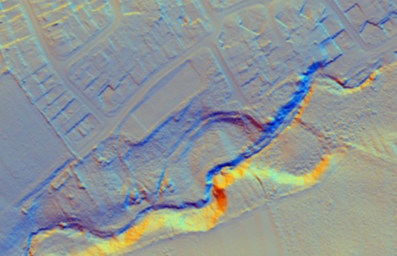
The mill lade is still clearly seen on the ground to the north of the burn, as are the remains of the weir.
As a result of the government promotion of the growing of flax the crop was grown in significant quantities in the Slamannan area and the mill was converted into a lint mill in the late eighteenth century.
On 8 January 1870 an unfortunate incident occurred. Alexander Waddell, a boy of six years of age, son of John Waddell, a joiner, residing at 52 West Street, Glasgow, was accidentally killed at Mr Gilchrist’s Lint Mill, Slamannan. The boy with his parents was on a visit to Slamannan and was playing about the mill when by some means he got entangled in the driving wheel, and received such serious injuries that he died within ten minutes (Glasgow Herald 13 January 1870, 5).
The mill was still being operated in 1881 when William Taylor appears as a flax miller. Living with his family was Catherine Forsyth who was ten years old and from the Linlithgow Poor House. It is likely that she had been placed at the mill to help with the work.
| FORENAMES | SURNAME | RELATION | STATUS | AGE | OCCUPATION | WHERE BORN |
|---|---|---|---|---|---|---|
| William | TAYLOR | Head | Married | 35 | Flax Miller | New Monkland, Lanark |
| Agnes | TAYLOR | Wife | Married | 27 | Muiravonside | |
| Maggie | TAYLOR | Daughter | 4 | Slamannan | ||
| Jane | TAYLOR | Daughter | 2 | Slamannan | ||
| Catherine | FORSYTH | Servant | 10 | Scholar | From Linlithgow Poor House |
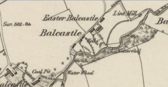
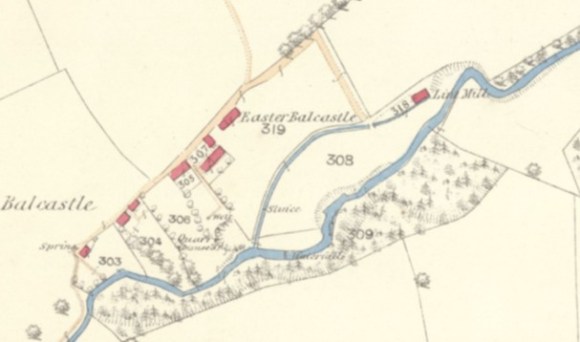
By that time a second building had been erected on the south side of the lade opposite the first. However, the Ordnance Survey map of 1896 does not name the mill and the course of the lade is deliberately omitted showing that the mill was no longer working, though Waugh
thought that it continued into the beginning of the twentieth century (Waugh 1977, 87). Latterly the building was used as the dwelling of the McKenzie family but was demolished in 1957 to make way for an extension of the council’s housing scheme.
The lade may still be made out on the ground as an earthwork and appears on the Lidar image.
Bibliography
| Reid, J. | 2005 | ‘East Stirlingshire Mills: Part 2,’ Calatria 22, 33-58. (p.53) |
| Waugh, J. | 1977 | Slamannan Parish through the Changing Years. “Milling of corn must have been an active industry in the Slamannan Parish right back to very early farming days. The mill at Balcastle is marked in Blaeu’s Map of Stirlingshire, printed in 1651 as is also the Linmill at Avonbridge. Both of those mills had belonged to the feudal superiors, but the first of those landlords we know of was Sir Gilbert Malherbe, the Lord of Slamannan, in the 13th century. There were a number of these feudal superiors throughout the centuries. The Balcastle Mill was still being used till the end of the 19th century, and the beginning of this century. In 1951 it was the home of the late Mr. & Mrs. John McKenzie and at that time the building was little altered from what it had been 60 years before. It was demolished in 1957 when the Balcastle housing scheme was being extended. The old Linmill at Avonbridge is now a ruin.” [p.87] |
