SMR 2016 / NS 8601 7005
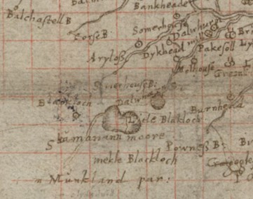
Black Loch is a very common name for lochs in central and southern Scotland and probably comes from the peaty nature of the water – most are found on moorland. The Mekle (Great) and Litle Blackloch at Slamannan appear on Pont’s map of c1590 as natural pools of water.
They were evidently valued for their stock of fish and fowl which were the property of the landowners and feudal superiors. In 1664 two men armed with hagbuts were recorded to have “schote and auld duik having zung (young) dukis with her at the Litill Loche” (Reid 2009, 184). Sibbald also mentions the lochs in 1707. In 1723 Johnstone of Kirkland gives more detail:
“there is two lochs viz. the Black Loch which is pretty large, and the little loch; here there is fishing for pearches and pikes in aboundance. The Muir road from Linlithgow bridge to Glasgow goes by the southside of thir lochs.”
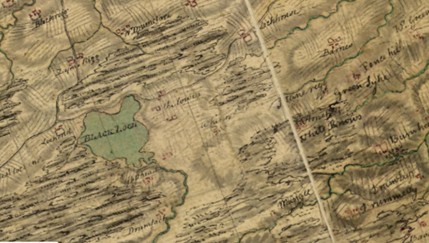
That road in fact goes by the north side of the lochs and is shown on Roy’s map of c1755.
The North Calder Water exits from the south-east side of the Black Loch and then turns westward to head towards Caldercruix. The Little Black Loch drained to the east, but as this became blocked the loch silted up and no longer exists as an open stretch of water. This process has taken some considerable time and can be traced on the various maps.
The Black Loch Moss forms a small, level plateau to the south west of the Black Loch. This raised bog originally developed from a waterlogged hollow lying between low ridges of glacial till on the edge of the Slamannan Plateau. As the raised dome of peat has grown, it has gradually filled the hollow and now only small areas of the surrounding mineral ridges remain exposed. The surface pattern of raised bogs usually consist of well-defined bog hollows within a mosaic of wide ridges and hummocks, however Black Loch Moss is unusual as there is little variation in the surface topography. This is due to a proliferation of bog mosses and a very high water table, especially in the central area. Within this area there is a luxuriant growth of Sphagnum papillosum with small pockets of S. magellanicum, often in association with carpets of the locally rare cranberry and bog asphodel. The more usual pattern of hummocks and ridges only arises toward the south western quarter of the site where the hollows are at the level of the water table and dominated by Sphagnum cuspidatum and S. tenellum, with S. capillifolium occasionally found on the drier ridges. The field layer above the moss carpet is dominated by heather and crossed leaved heath. Common cottongrass and hare’s-tail cottongrass is interspersed throughout, with very occasional patches of crowberry. The ‘lagg’ on the margins of a raised bog is a natural stream fed by runoff derived from the bog surface. However, it is more readily identified by an associated ‘fen’ type plant community. At Black Loch Moss the original lagg has been replaced by a secondary lagg that has arisen as the result of peat cutting in the past. In effect the lagg has moved inward as the area of raised bog has retreated. At Black Loch Moss the secondary lagg along the southern edge of the mire is relatively species rich, the presence of whorled caraway being of particular note. It was designated as a Site of Special Scientific Interest or SSSI (Scottish Natural Heritage 2010). Peat was a valuable fuel resource in the historic period.
Writing in the early 1790s the minister of Slamannan wrote the Old Statistical Account which states that there were two lochs
“upon the S.W. side of the old parish, called the little and the great Black Lochs; the one of which, namely the Little Black Loch, runs E., and the other, the great Black loch, which is about half a mile W. from the other, and lies upon the boundaries of this and the East Monkland parish, runs W. It hath lately been made a reservoir to the great canal between the Forth and Clyde, by the run of the water of Calder, by which it is carried into the Monkland canal, and from that, by a cut near Glasgow, conveyed into the large canal. There are some trouts in the water of Avon, and also in the 2 Black Lochs, and some perches and eels.”
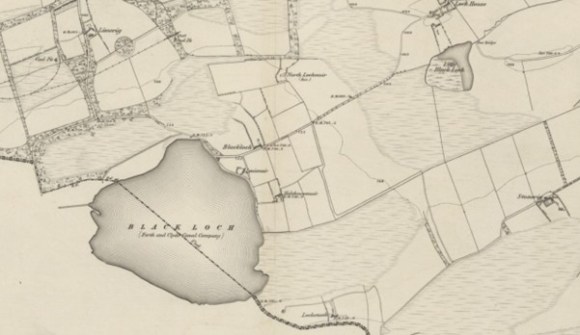
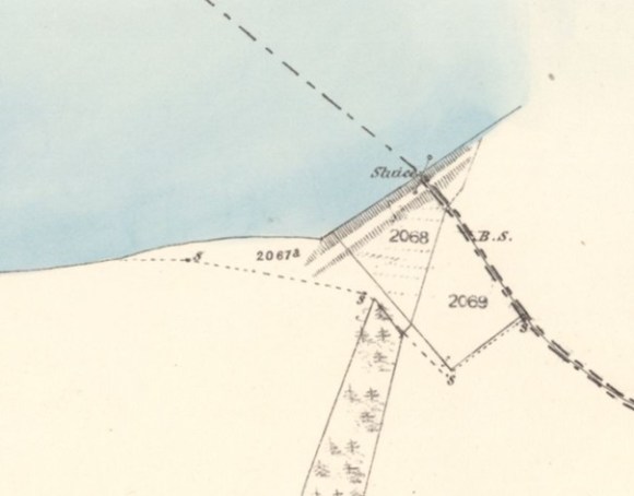
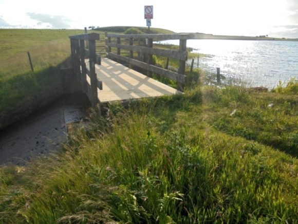
An earth embankment was constructed at the south-east end of the loch so that the water level could be raised. March or boundary stones engraved “FCN” were placed around the land owned by the Forth & Clyde Canal Navigation. Some of these are marked on the 1858 Ordnance Survey map near to the sluice, but most have now been requisitioned by locals in Limerigg for use as garden ornaments. Similar stones may still be seen in situ at the Hillend Reservoir at Caldercruix into which the water flows.
The increase in depth of the loch was not great, being in the region of 6ft, but added significantly to the volume of water stored. The maps show that the overall shape of the loch, now a reservoir, changed little. It covers 124 acres.
The Ordnance Surveyors simply described it as :
“A large sheet of water situate on the boundary between the counties of Stirling and Lanark, and is partly in both counties. That portion occurring in Stirlingshire is the property of Mr Robert Inglis, Linn Mill by Avonbridge.”
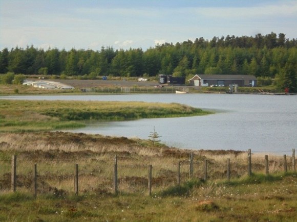
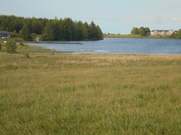
In the 1950s the Forestry Commission planted areas of pine and Sitka spruce on the open moorland immediately to the north of the Black Loch and around the Little Black Loch, considerably changing the appearance of the countryside.
The 1961 Statistical Account noted that :
“Some fifty members of a water ski-ing club with five motor boats have been practising their skill since 1959.”
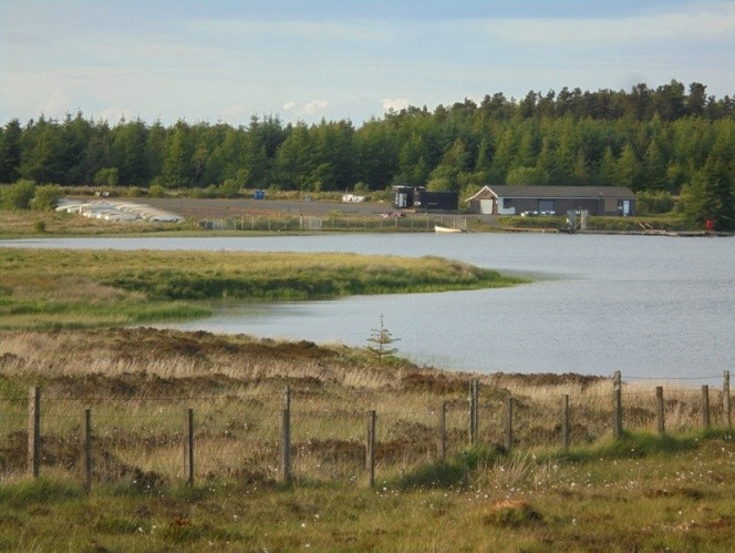
According to the locals this was initiated by Dr Arthur who had taken up the sport when on holiday in the Mediterranean. The loch is now used for fly fishing, swimming, kayaking and paddle boarding. The Black Loch Fishery is located at the west end of the loch and the water is stocked on a weekly basis with several different types of trout including Brown, Rainbow and Hard Fighting Blues.
Bibliography
| NSA | 1961 | Quoted at (1) below |
| Johnston, A. | 2015 | ‘Falkirk in 1723,’ Calatria 32, 1-4 |
| Scottish Natural Heritage | 2010 | Black Loch Moss Site of Special Scientific Interest: Site Management Statement. |
| Sibbald, R. | 1707 | History and Description of Stirlingshire, Ancient and Modern. |
- “The work of the Forestry Commission in recent times is a fine effort to improve the area which should prove valuable in the future. Two sections of land in the Limerigg-Slamannan area are being planted, a total area of more than 400 acres. One section lies near and round the Little Black Loch and the second is north and north-west of the Black Loch. The tree planted is, on deep peat, the pinis contorta or lodgepole pine while the Sitka Spruce is used on shallower peat. In addition local shelter-belts have been created in various areas. A charming tree-planting ceremony at Limerigg was carried out in March 1961, in which local children planted a number of hardwood trees. By this and other methods interest in and appreciation of the woodlands may be fostered in young people and a permanent improvement effected in the landscape…
- Some of the young people are showing great interest in a new sport which is developing on the Black Loch. Some fifty members of a water ski-ing club with five motor boats have been practising their skill since 1959.”
