SMR 108 / NS 974 782
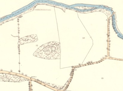
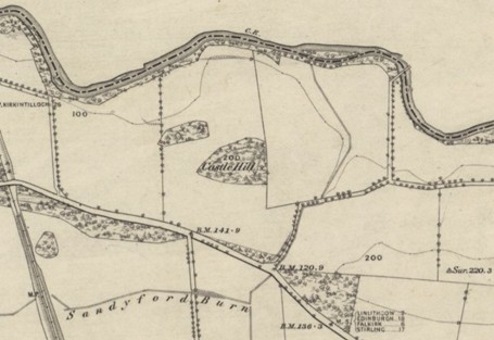
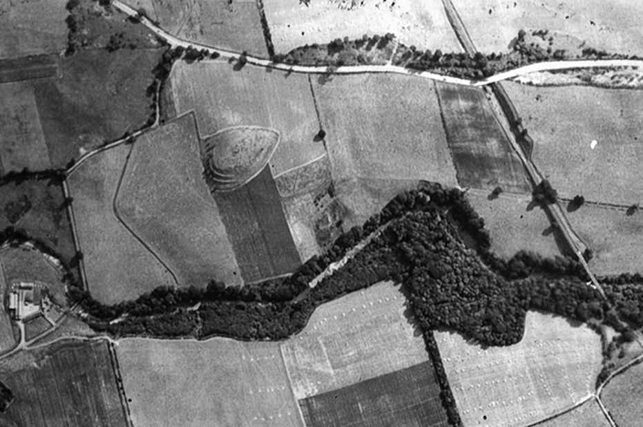
Castle Hill was located to the south of the River Avon a little to the west of the Sandyford Burn in the parish of Muiravonside in an area of gravelly soil. It followed the trend of the local topography and was aligned west/east with a broad steep slope to the east and a shallower tapering slope to the west. According to the New Statistical Account of 1843 there was a triple set of ditches on the north-east side of the hill and these terraces are depicted on the first edition Ordnance Survey map. Unfortunately, the hill was removed during gravel extraction in the 1960s and so its true nature can no longer be determined. Another “fort” is shown on the early Ordnance Survey maps to the west of Avonbank Farm, and a possible defended hill can still be seen immediately to the south east at the junction of the Linlithgow and Kinneil Mills roads. Further south, at Easter Manuel, a similar hill is marked by prominent terraces and despite the name it is possible that the platforms at Castle Hill were of this nature. Castle Hill, Easter Manuel and Avonbank (Sighthill) all have Bronze age burials in close association with them.
Cists were found on or near the Castle Hill in the early 19th century according to the NSA. Then, in the early 1960s “stone coffins” were reputedly destroyed during gravel extraction which took away the west side of the Hill (Marriot 1968, 86). More were discovered in 1965 immediately to the east of the Hill, between it and the Sandyford Burn.
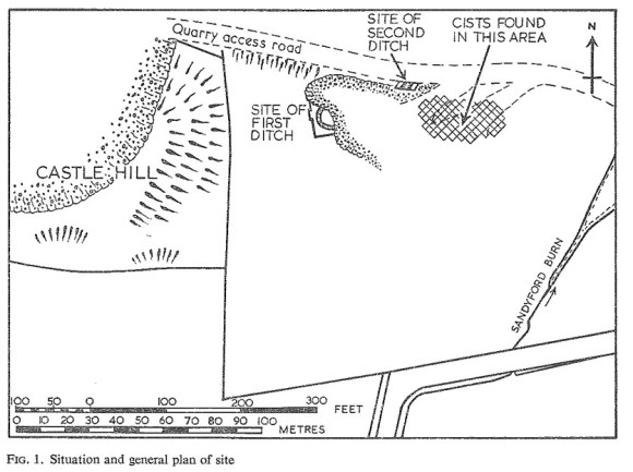
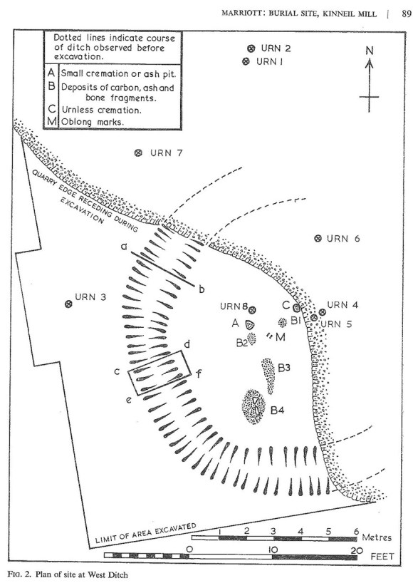
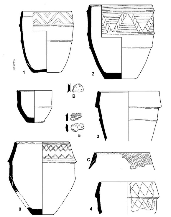
Several were removed before archaeologists recorded the two remaining ones. These were short cists, one containing a crouched inhumation and the other a Food Vessel. The finds are in the National Museum of Scotland. The excavation also revealed a ring-ditch, c11m in diameter, within the area of which were several cremation burials and four cinerary urns. A bone toggle or bead came from one of these. Areas of burning within the ditch suggested that cremations has taken place on the spot. However, as one of the urns protruded above the level of these burnt patches it is likely that a mound or barrow covered them. Three more urns were found in the vicinity and part of a second ditch hinted at a similar enclosure to the north-east (Marriot 1968). A radiocarbon date of 1880-1600BC was later obtained from cremated bone associated with one of the cordoned urns
Bibliography
| Archives; Falkirk Museums | List of finds in NMS in SMR | |
| Bailey, G.B. | 1996 | ‘The Graveyards of the Falkirk District: Part I,’ Calatria 9, 1-34. p.2, 25 |
| Discovery and Excavation in Scotland; | Council for Scottish Archaeology; York Buildings 1 Queen St Edinburgh 1965, p.37-8; 2002, p.154. | |
| Marriot, J. | 1968 | ‘A Bronze Age Burial Site at Kinneil Mill, Stirlingshire,’ Proc Soc Antiq Scot 100, 86-99. |
| McFarlan, J. | 1843 | New Statistical Account of the Parish of Muiravonside. “The origin of the most ancient remains in the parish is involved in deep obscurity. They consist of a series of fortified eminences, extending from Harlelaw, near Easter Manuel, by Castlehill, to Sight Hill. The last two present a steep face of about 150 feet in height to the valley of the Avon, upon which a triple trench had been formed, presenting now the appearance of three parallel roads towards the north-east, as if the attack were expected from that quarter. Whether they were raised by the original Celtic inhabitants against Danish invaders from the Lothians, (* Chalmer’s Caledonia) or to retard the advance of the Romans or the Scots towards Camelon, long defended against both, (~ Holinshed) it is impossible now to determine with any certainty. The quantity of stone-coffins found at Linlithgow Bridge, Castle Hill, Sight Hill, and Brakes, on the flanks and in the rear of these defences, leave no doubt that the place was one of carnage.” |
| RCAHMS | 1963 | Stirlingshire: An Inventory of the Ancient Monuments. “The New Statistical Account records the discovery of a cist at Castle Hill.” [p.63, no. 27] |
