SMR 455 / NS 791 776
The presence of a Roman road from Clydesdale to the central section of the Antonine Wall was proposed by Sibbald as early as 1707. The evidence for this road is usefully summarised in the Stirlingshire Inventory (RCAHMS 1963, 116-118) where its very existence is challenged. However, the Royal Commission’s conjecture that the part of the road found at Castlecary in 1902 was only part of a loop road is ridiculous; its alternative that it may just have been a local service road is possible. OGS Crawford was aware of the lack of firm evidence from further south, but believed this to result from the nature of the Roman building programme. Those sections of the roads near to the forts were better constructed because they saw the heaviest use and were built first. Had the Roman occupation continued then the other sections would have been improved with time (Crawford 1949, 16 & 44). The Vindolanda letters tell us how poor the original roads in the north of England were. It should also be observed that many of the contemporary roads shown on Roy’s 1755 map have vanished without a trace in just 250 years.
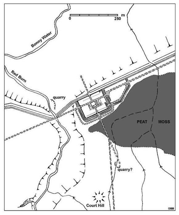
From the south gate of the fort at Castlecary a long causeway traversed part of the peat moss. The causeway is mentioned in passing by Nimmo (1777. 7) and its northern stump was partially excavated in 2010 (Bailey 2021, 527-540). It consisted of a clay raft with stones mixed in. Roman pottery and flue tiles had been dumped along its eastern margin. This road was traced for 1000ft to the south in 1902 (Christison & Buchanan 1903, 329), passing close to the medieval motte of Court Hill.
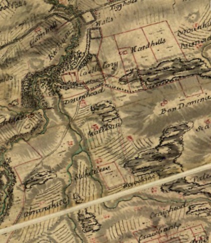
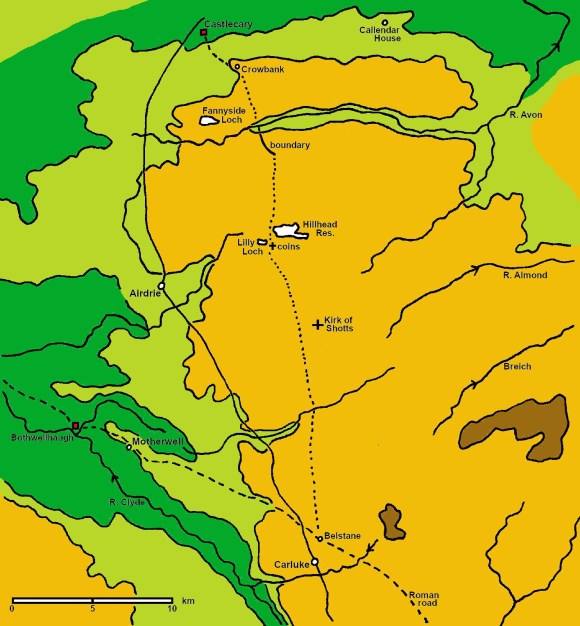
From there its course is a matter of conjecture. Roy depicts it on his Great Map as going by Crow-bank and on Plate XXXV of the Military Antiquities as far as the crossing of the Walton Burn. He also heard it “affirmed that a Roman way issued, leading towards the south, by Crow-bank, and Fannyside, and that the stones of it were lately dug up.” He then speculated that the most likely route for it was by way of Glentore, Crooked-dykes, Kirk of Shotts, Murdostoun and Hyndshaw to Belstane, near Carluke.
Davidson thought that he could trace the road on the ground as far as Crowbank (Davidson 1952), though he afterwards admitted that the road metalling that he observed could have been of any date (RCAHMS 1963). That it was already old by the time of Roy does suggest an early date for the road.
The county boundary between the River Avon at Thieves Hill (NS 8189 7324) and Low Roughrigg (NS 8280 7164) is on an appropriate line for such a road and has a small causeway along its west side for part of this distance. There are large stones in the banks of the river at Thieves Hill where the high ground on either side meet. It has evidently been a crossing at some time.
The discovery of ancient road material at the sluices to Lilly Loch and a nearby Roman coin hoard were thought to confirm the line to the south of Caldercruix, though this is far from certain. The route suggested by Roy would have taken the road across the high moors. Although the Romans did often lead their roads across such open country, the course taken by the modern A74 would have been more appropriate. Indeed, a road connecting the Roman fort at Bothwellhaugh to Castlecary would seem to be more suited.
Bibliography
| Bailey, G.B. | 2021 | The Antonine Wall in Falkirk District. |
| Christison, D. & Buchanan, M. | 1903 | ‘Excavation of Castlecary fort on the Antonine Vallum’, Proc Soc Antiq Scot, 37 (1902-03), 271-346. [p.329] “Military Way, South. (Quoted at 1 below) |
| Crawford, O.G.S. | 1949 | Topography of Roman Scotland North of the Antonine Wall. [p.44] (Quoted at 2 below) |
| Davidson, J.M. | 1952 | ‘The supposed road from Clydesdale to Castlecary,’ 82-87. in Miller, S.N. The Roman occupation of South-Western Scotland; being reports of excavations and surveys carried out under the auspices of the Glasgow Archaeological Society. |
| Nimmo | 1777 | [p.7] “The outer wall of the fort hath been surrounded with a double ditch or vallum, which is still filled with water upon the south side, where the entry hath been by a large causeway intersecting the ditch. |
| RCAHMS | 1963 | Stirlingshire: An Inventory of Ancient Monuments. [p.116-118]. (Quoted at 3 below) |
| Roy, W. | [p.106-107] [Gordon] (Quoted at 4 below) | |
| Stuart, R. | 1852 | Caledonia Romana [p.352} (Quoted at 5 below) |
| Samuel Lewis (ED) | 1846 | “A Topographical Dictionary of Scotland” (Quoted at 6 below) |
| New Statistical Account ; Geoff Bailey; Falkirk (Quoted at 7 below) |
- [p.329] “Military Way, South. This road was clearly traced for about 1000 feet of its length beyond the fort (see fig 1.).
- Issuing from the south gate, it is carried in a direct line through the morass on front of the south wall. The width across the stone bottoming is 30 feet at this part.
- It continues the direct course till it reaches what appears to be an old stone quarry, beyond which it is not traceable.
- A branch, 15 feet in width, strikes off the direct line at 200 feet from the wall of the fort, and , with an inclination more to the south than the previous road, rises to the summit of the higher ground, along which it continues. On its approach to the high ground it crosses a small streamlet at an angle to it. Both sides of the streamlet are built with large stones for a length corresponding to the width of the road adjacent to it. The width of the streamlet being under 2 feet, it would be easily stepped, and the level is made high, so as to give dry crossing.”
- [p.44] “no one has ever claimed that it [the road from Camelon] continued directly southwards, the only road so doing of which there is any real evidence being that from the fort of Castle Carey, with which we are not now concerned. Although I spent a whole day in 1937 looking for it without success, I still believe it exists and that it should be possible to replot its course on the map.” [p.15-16] “The existence of short lengths of road is certain; is it possible that the making of such was carried out as part of the regular routine of fort-construction or that the construction of the main lengths of the road was postponed to a later date, and sometimes, as here, never carried out? From some other forts – Inchtuthil and Castle Carey for instance – there issue roads which seem to end prematurely, though of course this may eventually be found not to be so. But the hypothesis seems worth consideration. The making of branch roads to join outlying forts to the main road might well be the last item on a programme which here was never completed.”
- [p.116-118]. “It has often been suggested that a Roman road branched off the Clydesdale route in the vicinity of Carluke, and ran thence northwards to the Antonine Wall. As the following synopsis will show, no convincing evidence has ever been produced in support of this supposed road, and widely different opinions have been entertained regarding its precise course.
- (i) Sibbald (1707) merely mentions a local tradition that a Roman road ran from Carnwath to Camelon.
- (ii) Gordon’s map (1726) marks the course of the Roman trunk road from Carlisle reasonably accurately as far as Biggar. But beyond Biggar he projects it more or less in a straight line through Carnwath to Watling Lodge, where a gap in the Antonine Wall gave passage to the Roman road that led northwards to the fort of Camelon and thence to Perthshire. Gordon was apparently unaware that the Biggar road continued in the direction of Inveresk, nor did he know of the branch leading through Clydesdale to the W. end of the Antonine Wall, and in linking Biggar with Camelon it can only be assumed that he was either following the local tradition referred to by Sibbald, or was tying up, in the most direct manner possible, what he conceived to be two loose ends in the Roman road-system.
- (iii) Roy (c1755) reports that he failed to find any trace of Gordon’s road leading southwards from the gap in the Antonine Wall, and that the local inhabitants had no knowledge of the existence of such a road. He adds, however, that a Roman road is said to have run S. from the fort at Castlecary, about 5 miles W. of Watling lodge, by Crow-bank, and Fannyside, and that the stones of it were lately dug up.” He marks the beginning of this supposed road, as far as the crossing of the Walton Burn, on his Plate XXXV, and suggests, though purely as a speculation, that the most likely route for it to follow thereafter would be by way of Glentore, “Crooked-dykes,” Kirk of Shotts, Murdostoun and Hyndshaw to Belstane, near Carluke.
- (iv) Stuart (1844) states that a branch road left the road up the Clyde valley at Belstane and “appears to have gone nearly due north by the Kirk of Shotts, either to the station at Castlecary, or to that at Camelon.” He suggests that it may even have divided, a branch running to each fort, and records a stretch as having been traced, shortly before 1844, between Belstane and Castlehill (843518) and also “supposed vestiges” as having been dug up on the farm of Bracco, at a site identified in a footnote as the outflow of the Lilly Loch (8266). The road observed between Belstane and Castlehill must, however, have been a portion of the Clydesdale road which runs through both places, while Mr Davidson (see below) has produced convincing reasons for discounting the supposed Roman remains at the Litty Loch.
- (v) Since 1867 all the editions of the 1-inch O.S. map, prior to the current (7th) series, have marked a Roman road, as a site, leading S. from Castlecary to the modern road at Walton farm, and thence SE. for a further three-quarters of a mile to the Walton Burn. The relevant entry in the O.S. Name Book makes it clear that, in plotting this road, the surveyors were merely transferring the line given on Roy’s plate as best they could “no person in the neighbourhood being able,” as they say, “to point the road out on the ground.” The road has rightly been omitted from all published 6-inch O.S. maps.
- (vi) It is claimed that during the excavations in 1902 a road was traced for about 1000 ft from the S. gate of the fort, terminating at what appeared to be an old stone-quarry. At a distance of 200ft from the fort this road is said to have thrown off a branch, 15 ft wide; and on an accompanying sketch-map the branch is called “Military Way from the South,” and is shown as running due S. for about half a mile to an unnamed tributary of the Red Burn, its further course being cut off by the margin of the map. In the absence of any photographs or measured drawings, it is difficult to know how far this information can be relied upon. On the one hand it s likely enough that a metalled road issued from the S. gate of the fort, and the excavators can hardly have invented the branch road, particularly since they state that its width was only half that of he “quarry” road. On the other hand it is highly doubtful whether either road was traced to the extent claimed on the sketch map. The embankment of the Glasgow and Stirling railway cuts across the line of the “quarry” road only 500 ft from the fort, and the so-called “quarry” lies not more than 200 ft beyond the embankment and is, in fact, purely a natural hollow at the foot of a strip of rising ground. Nor are any indications of the branch road visible on the surface at the present time – the stone revetment on either side of the streamlet that crosses the line being comparatively modern, and not, as the excavators believed, the remains of a Roma culvert.
- (vii) In a recent study of the whole question, Mr J.M. Davidson (in Miller ed) has argued strongly against the existence of a branch road from Belstane to Castlecary on the lines suggested by Roy and Stuart, adducing the negative results of his own field investigations , and also showing sound reasons for rejecting the supposed Roman remains at the Lilly Loch. But his observations led him to believe that a road had led from Castlecary to Crowbank, 2 miles to the S., where he suggested there might have been a Roman signal-post. On reconsideration, however, Mr Davison has agreed that the various metalled surfaces which he took to be the remains of a Roman road between Castlecary and Crowbank are all of a more recent date; while excavation has shown that the short length of stone kerbing to which her refers (ibid, 87), on the E. side of Crowbank farmhouse, is not Roman work but is simply the lowest course of a former garden-wall.
- No intensive field-work has been done outside the confines of Stirlingshire, but it is quite cear from the foregoing survey that no evidence has yet emerged for the existence of a Roman road leading from Clydesdale wither to Camelon or to Castlecary, but neither the “quarry” road nor the branch road reported there need necessarily have served anything more than purely local purposes. For it is possible that what the excavators actually found was merely the junction between a loop road, skirting round the S. side of the fort, and the road that issued from the S. gate. Loop roads were commonly employed on the Antonine Wall to enable through traffic to avoid passing through each of the forts; and at Castlecary such a loop road may well have been required to make a wider detour owing to the morass that covered the S. front of the fort.
- [p.106-107] [Gordon] “seems to have been ignorant of the continuation of the principal Roman way from the parish of Carluke towards the west end of the wall. And, in lieu thereof, makes it cross the country directly to Camelon, near Falkirk: but when this wall was surveyed in 1755, though vestiges of the road leading from it northwards, through the ruins of Camelon, were found to be very distinct; yet no continuation of the road southward could be perceived, nor do the inhabitants of these parts know of any traces of it on that side of the wall, and indeed the country through which it must have been carried, according to the direction assigned it in the Itinerarium, is so extremely morass, as to have rendered it very difficult, if not impracticable, to execute it.
- From the station of Castle Cary it is affirmed that a Roman way issued, leading towards the south, by Crow-bank, and Fannyside, and that the stones of it were lately dug up. That the Romans must have been desirous to effect such a communication, is reasonable enough to suppose; they might even have begun it; but it seems doubtful whether it was ever completed. However, from Fannyside, the most likely route for it to follow would appear to be by Glentore and Crooked-dykes, towards the Kirk of Shots, or perhaps a little way to the westward of it; and thence, by Murdistone and Hyndshaw, to Belstone, near Carluke.”
- [p.352] “The second line, diverging near Carluke, appears to have gone nearly due north by the Kirk of Shotts, either to the station at Castlecary, or to that at Camelon, near Falkirk – probably to both, for it seems by no means unlikely that, as this causeway approached the Wall, it may have divided into two branches, which respectively conducted to those important stations. A part of this road was recently traced, leading from Belstone to Castlehill; and a few years ago some of its supposed vestiges were likewise discovered on the farm of Braco, formerly mentioned, and where a number of Roman ‘denarii’ were recently found. (The remains of the ancient causeway which are here alluded to, were accidentally laid open by some workmen employed in repairing the sluices of a small compensation reservoir called the Lilly Loch. The discovery is somewhat interesting, as showing the course of this ‘Via’ to have led by Braco – a circumstance till then uncertain. The coins here mentioned were discovered in 1842, in removing some sods from the surface of a piece of land. They amounted to several hundreds, principally of Nerva, Trajan, Hadrian, Antoninus Pius, and Faustina, and most of them were in good preservation. Some of them were procured by Dr. Clark of Wester Moffat, and by John Buchanan, Esq. Glasgow, in whose possession they now are.) The portion then exposed pointed in a direct line to Castlecary, which, in connection with the fact of a paved road having been traced from that station leading directly towards Braco, leaves little doubt of a military way having anciently passed between these two places; however conjectural may be the opinion which supposes a similar branch to have been carried forward in the direction of Falkirk, to join the great road which led from Camelon to the North.
- [p259] “The principal object of interest in that vicinity, next to the ‘Valla’ of the fort itself, was the Roman road from Clydesdale; which, diverging from the line to West Kilpatrick, at about a mile to the north of Carluke, passed, it is believed, not far from the Kirk of Shotts; and, after keeping the rising grounds to the eastward of the Red-burn, terminated within the intrenchments of Castlecary. (Some portion of this road is still visible in the Moss of Fannyside.) “Some few of its traces may still be perceived among the woods in the vicinity of the old baronial tower, which stands upon the banks of the Red-burn, and whose time-shaken walls, in conjunction with the attractive scenery around, entice, we may suppose, many more visitors to this neighbourhood than do any associations connected with historic records of Roman times.”
- “The remains of several of the forts erected by Agricola may still be seen in the direction of the Vallum built afterwards by Antoninus. At Castlecary, a small hamlet at the western extremity of the parish, the site of one of these forts, a field of six acres in extent, now covered with grass, may be distinctly traced; a part of the vaulted foundations is remaining underneath the surface and many of the stones belonging to the fort have been used in the enclosure of the field. The old tower of Castlecary which is a very ancient structure and said to be Roman is still tolerably entire, and is inhabited by the Earl of Zetland’s forester; at this hamlet, also, is a landing place for passengers by the canal boats. Stones with various inscriptions, now preserved in the museum of the College of Glasgow, have been dug up in various parts of the ditch which defended the Roman Wall, and of various portions are yet discernible in Calendar Park, and in the grounds of Bantaskin House. Vestiges remain of the Roman road that entered the parish at Castlecary, and; passed along the south side of the wall near Roughcastle, crossed the wall, and led to the fort at Camelon, and thence to the river Carron, where it entered the parish of Larbert; and in excavating the Forth and Clyde Canal at no great distance, a Roman granary has been discovered, in which was wheat of a blackish colour.”
- “A Roman highway entered the parish at Castlecary fort, and ran along the south side of Graham’s Dyke. Half a mile east of Roughcastle, it crossed the wall of Antoninus and came to the ancient station at Camelon, from which it held on to the River Carron, where it entered the parish of Larbert Some parts of it remain, and are now used as a road. At the time of cutting the Forth and Clyde Canal, which is at no great distance, a Roman granary or cell was discovered, which contained, a considerable quantity of wheat of a blackish colour. Portions of this wheat are in the possession of different individuals in the neighbourhood.”
