SMR 502 / NS 8570 7320
Castlehill was part of Slamannan Mure and is mentioned as early as 1618. It was part of the Livingstones of Callendar holdings in the parish. In 1723 Johnstone of Kirkland associated Castlehill with an ancient earthwork on a hill and distinguishes it from the motte of Balmulzier near the church:
“There has been an old fortifications a little South of the Kirk of which there remains very little vestige, but is commonly called the Castle hill, and opposite, to it upon the north side of the Kirk is a little green hill called the mote which appears to be artificially made, but upon what design is not known. There is a burn runs by the Kirk called Castlehill burn, and has a bridge thereon of one arch.”
This is a particularly useful statement as it informs us that the stream formed the north-east and eastern boundary of the Lands of Castlehill which stretched some distance to the west. In 1618 the Rankines were resident at Castlehill and that family remained proprietors for centuries – well into the 20th century. It was their willingness to feu the ground along the mains roads that led, from the 1850s onwards, to the creation of the modern village of Slamannan. It was on the Lands of Castlehill that the livestock markets were held in the middle of the 19th century. Today the name is perpetuated in that of the petrol station in the High Street which occupies the site of Castlehill Farm.
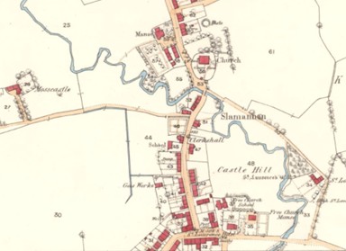
There are several names in Slamannan incorporating the word “castle.” Mosscastle lies to the north-west of Castle Hill and presumably refers to the field associated with it. Balcastle is much further to the south-west and although also part of the Livingstone holdings was not part of Castlehill. It may refer to an entirely separate fortification – the “Bal” prefix also indicating an early date. However, the 12th century castle to the north of the church was called the “Motte” or “Moat.”
The Ordnance Surveyors were in the area shortly after the construction of the Slamannan Railway and the initial formation of the village. In 1860 they described Castle Hill as:
“A small arable eminence standing between the village of Slamannan and Kirk Burn. A fort, or castle, is said to have stood on this hill no vestige of which now remains. Neither does the oldest inhabitant of the village remember of seeing any vestige of them. The farmsteading which once stood on it has been pulled down. Property of Mrs Waddell, Balquhatston, Slamannan.”
Further along the High Street, where the petrol station is now was new Castlehill Farm, which was
“A large farmsteading one storey in height, slated and in good repair. Property of Provost Rankine, Auchengray.”
It was on Castle Hill that the police station was built in 1879. The name was changed to Calton Hill, which sounded more cultured.
It is not known to what form of fortification Castle Hill refers. Mottes at Larbert, Castlecary and Muiravonside where all called Castle Hill, but elsewhere the name refers to earlier earthworks. Given the proximity of the motte at Balmulzier in Slamannan, and the presence there of the church, it is unlikely that the Castle Hill was occupied by a contemporary motte (though John Reid does point out that there were two major landowners in the parish). It is more probable that it refers to an Iron Age or Dark Age hill fort.
Bibliography
| Walter MacFarlane | 1906 | Geographical Collections Volume 1 (Quoted at 1 below) |
| Falkirk Herald | Various (Quoted at 2 below) | |
| Macnair, J | Old Statistical Account – Slamannan (Quoted at 3 below) | |
| New Statistical Account (Quoted at 4 below) | ||
| Ordnance Survey Archaeology Sheet |
- “There has been an old fortifications a little South of the Kirk of which there remains very little vestige, but is commonly called the Castle hill, and opposite, to it upon the north side of the Kirk is a little green hill called the mote which appears to be artificially made, but upon what design is not known. There is a burn runs by the Kirk called Castlehill burn, and has a bridge thereon of one arch.”
- Falkirk Herald
- FH 10 January 1850, 3: At Govan, on the 29th ultimo, aged 86 years, George Rankin, Esq., late of Castlehill, fifty years manager of the Carron Company’s Works at Carronbank and Grangemouth.
- FH 1 August 1885, 1: For Sale… contained in a Bond and Disposition in Security), All and WHOLE that Piece of Ground part of the Lands of CASTLEHILL, lying upon the North Side of the Road leading from Slamannan Airdrie, extending to 42 poles and 13 yards or thereby with…
- FH 5 August 1933, 2: To LET, with Entry at the Term of Martinmas next, the FARM of CASTLEHILL, in the Parish of SLAMANNAN. The Farm Steading is situated in the Village of Slamannan, conveniently for Dairying purposes. The Lands extend to approximately 47 acres…
- Old Statistical Account Slamannan – “…there is, upon the south-side of the church, at a little distance, a small hill, which is called Castle Hill, where, they say, anciently stood a castle. There are no remains of it now, only the farm-house upon the west side of it, goes by the same name.”
- New Statistical Account – “there is a rising ground a little to the south of the church called Castle-hill, where a fort once stood, but of which no vestige remains, excepting the farm-house, which still goes by the name Castle-hill”
- Ordnance Survey Archaeology Sheet [Marginal] “A small hill, which is called Castle Hill, where they say, anciently stood a castle” is situated a little distance south of Slamannan Church. There are now no remains of the castle, only the farmhouse on the west side of it goes by the same name. This is a small, but prominent hill, in the centre of Slamannan. The police station occupies the summit, and a quarry has been dug into the east side of the hill. Elsewhere, the slopes are grass covered. There is no trace of any early building on the hill.
