SMR 498 / NS 8731 8040
The Old Statistical Account of 1791 for the parish of Slamannan mentions ‘Kill Hills’ as the scene of a battle. The name, however, is a common one throughout this part of Scotland and refers to malt kilns, often associated with distilleries.
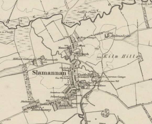
The 1st edition Ordnance Survey map places the name to the south of Balmulzier Farm, in a coll between two hills – one at later occupied by the ROC station Hillhead and the other by Balmulzier Farm. The southern of the two is more prominent and corresponds best to the OSA that puts it east of Castle Hill.
Bibliography
| Rev James MacNair | 1795 | Parish of Slamannan or St Laurence. Old Statistical Account; County of Stirling (Quoted at 1 below) |
| New Statistical Account (Quoted at 2 below) | ||
| Ordnance Survey | Archaeology Sheet; Ordnance Survey (Quoted at 3 below) | |
| Ordnance Survey | Name Book (Quoted at 4 below) |
- “…Castle Hill, where, they say, anciently stood a castle. There are no remains of it now, only the farm-house upon the west side of it, goes by the same name. And a little to the eastward of this hill, there is another rising ground, where is thevestige of a trench, and which goes by the name of Killhills, because of the number, it is supposed, that were killed there.”
- “…Castle-hill; and a little to the eastward of this hill, there is another rising ground where there are still some remains of a trench, and which goes by the name of Kill-hills, because of the numbers which were supposed to have been slain there. Besides, there were adjacent to these, two cones of earth about forty yards separate, which are supposed to have been raised as monuments of peace, like the two at Dunipace. One of these still remain, and is evidently artificial: the other was levelled, and the church of St Lawrence built upon it; the former still goes by the name of the moat.” [p.274]
- “Kiln Hills – two small eminences. The writer of the N S A calls these “Kill Hills”, and assumes them to have been the scene of a battle, the name originating from the number of persons killed. He also alleges that the remains of a trench existed in them. All the authorities in the locality state that these statements are incorrect, and that the name derives from the number of malt kilns which existed along the sides of these hills some years ago, and when smuggling was carried on on a large scale throughout the parish. The existence of the ditch is considered imaginary. Balmuilzier farm stands on the northernmost hill.”
- KILN HILLS: “Two small eminencies on the farm of Balmulzier and Hillhead. The writer of the Statistical of this parish, calls these hills “Kill Hills”, assumes it to have been the scene of a battle, and supposes the name to have originated from the number of persons then killed, and that the remains of a trench existed on them. All the authorities in the locality assert that these statements are incorrect, and that the same was derived from the number of malt kilns which existed along the sides of these clay hills some years back, and when smuggling was carried on on a large scale throughout the parish. The existence of the ditch they consider imaginary. The farmsteading of Balmulzier stands on the summit of the northern most hill, and is the property of Miss A Waddell, Balquhatston, the southern hill is the property of Mr John Waugh, Hillhead, Slamannan.”
