SMR 242 / NS 9719 7640
History of the Nunnery
The nunnery dedicated to the Virgin Mary on the west bank of the River Avon to the west of Linlithgow was founded in the middle of the twelfth century by Malcolm IV and confirmed by his son, William the Lion (the history which follows is based upon Reid 1994). The date was between 1156 and 1164. Lands were assigned to the ecclesiastical establishment and these were perambulated for William’s charter by Thor, son of Swain, (probably the Sheriff of Lothian), and Geoffrey de Melville. Included in the gifts were the right of common pasture and an entitlement to as much wood and timber as the nuns might need for their own use for fencing and fuel. They also received the king’s protection:
“he wills and commands that the said nuns hold the said lands as freely and quietly as any alms throughout his lands are held and straitly prohibits anyone, upon pain of forfeiture, to injure them in any way within the bounds of the said lands” (Reid 1994, 89).
One of the reasons for the establishment of the nunnery at this location must have been to shelter important travellers using the main route west from Linlithgow. The peel at Linlithgow was only created in 1301. Scotichronicon states that :
“in the year 1164, following the advice of the [holy] Waltheof abbot of Melrose, the king founded the noble monastery of Coupar in Angus, and [before this] the community of Soutra for giving shelter to travellers, and the nuns of Manuel” (Book VIII, 7, 40-45).
Before the construction of Linlithgow Bridge the ford near the nunnery would have been on the road which continued north-westwards through Whitecross to Almond Castle. Savelnesford is mentioned in one of the earliest surviving charters for the estate of Muiravonside in 1189
“as the ancient road runs from Savelmesforde to the seat of St Morgan” (Reid Notes).
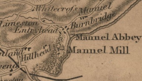
Whitecross would seem to derive its name from the road system there which marked one of the boundaries of the nunnery’s lands; white meaning holy. Just upstream from the nunnery the river was joined by the waters of the Manuel Burn and it would have been from it that the nuns’ drinking water would have come.

Further gifts, donations and benefices were made in subsequent years. Around 1196 King William added his revenues from the sheriffdom of Linlithgow, and of mills, money, wheat and flour from both the burgh and shire of Linlithgow. Alexander II confirmed the donation of the mills of Linlithgow, with all their sequels and appurtenances. The mills were those on the east side of the river a little to the south of Linlithgow Bridge (later known as the Burgh Mills, these were set in feu by the nuns to the burgh of Linlithgow in the 16th century).
In 1224 Alexander II also donated one and a half chalders of salt from the tiends of his saltpans on the Carse; and Roger de Avenel bestowed on the holy sisters a chalder of wheat, to be paid yearly by him and his heirs, out of his barns of Abercorn, at Christmas.
The Cistercians had nunneries at strategic places in Scotland – at Berwick, Coldstream, Elcho, Haddington and Manuel. The lives of the nuns would have followed a similar pattern to their male counterparts with much of the day spent in prayer and contemplation. The main difference was the presence of men in the nunneries. Since women were not permitted to take holy orders, priests were needed to tend to the nuns’ spiritual needs, saying mass, hearing confessions and administering the sacraments such as the Eucharist and Extreme Unction: the Last Rites for the dying. Male lay brothers would have been employed to perform some of the harder physical tasks, helping with farming and other manual work. Their help was particularly important as strict rules of enclosure would prevent the nuns from carrying out much of the manual work outside the confines of the buildings. Within the complex the nuns did most of the work, tending the gardens, cooking and the like. From 1220 resident lay-brothers generally lived outside the nuns’ enclosure. It was important that they, like any other resident or visiting males, remained separate from the nuns and it is probable that the later farm of Manuel started as a home farm for them.
Roger, prior of Manuel, witnessed a charter in 1190. He presumably looked after the establishment’s secular matters. Towards the end of the thirteenth century mention is found of Lady Christina, “Prioress of the nuns of Manwelle,” who on 28 July 1291 swore fealty at Linlithgow to Edward I of England. Five years later it was the new prioress, Alice, who made that oath in Berwick upon Tweed. Such acts seem to have protected the religious house as it survived the Wars of Independence relatively unscathed. As a consequence of swearing fealty, Edward ordered the sheriffs of Edinburgh and Ayr to reinstate the prioress in possession of her lands within their jurisdictions. The nunnery’s holdings were modestly extensive. Some damage was done at Manuel by the army of Edward III of England on its march towards Perth in the summer of 1335; for which the nuns received compensation.
The 18th century antiquarian Francis Grose reported that
“It is said the tomb of the prioress, Alice, was to be seen here a few years ago, upon which was her figure, with a distaff; an uncommon instrument to be put in the hands of a prioress.”
The graveyard was located to the south of the church, between it and the river. Over the centuries the number of burials multiplied. It was so extensive that it is evident that it was not merely the nuns who were interred in this holy spot. Lesser members of the local elite would also have found their last resting place there, accompanied by the prayers of the remaining nuns.
On 21 October 1301 Edward I made an offering at the high altar at Manuel (Reid 1994, 91). The following day he sent a letter from the nunnery to his treasurer, barons and chamberlains of the exchequer, complaining of shortage of money and provisions. Partly as a consequence he stayed in the Linlithgow area for several weeks. Whilst the English occupied Linlithgow they ensured that that burgh paid its annual alms to the priory.
In 1492 Lady Elizabeth, prioress of Manuel, issued a receipt to the sheriff of Linlithgow as discharge for the annual tiends. By the following year when the next receipt was signed it was by Lady Marjory. These prioresses undoubtedly came from powerful local families and may have been able to use their influence to stave off closure which seemed inevitable as there were then only five nuns. Dene William Craufurd, vicar of Falkirk, was acting as procurator for the prioress and convent of Manwell in 1505 during negotiations with the Burgh of Linlithgow over the mills near Linlithgow Bridge.
In 1506 Pope Julius II issued a commission to the abbots of Cambuskenneth and Balmerino, and to the provosts of the collegiate church of the Holy Trinity in Edinburgh, proposing to turn the nunnery into a house of Augustinian Friars Observantines. The priory survived this review and Lady Marjory was followed by Lady Elizabeth Hoppringle, who was prioress by 1515 and was still in office in 1528. She had resigned her post by 1543 in which year Mary, Queen of Scots, presented Lady Jonete Livingston to David, Cardinal of St Andrews, as the new prioress. Not long afterwards Alison Ramsay claimed expenses of 18d a day for the time that she spent in the “abbey of Manuale” whilst waiting to hear if she would be admitted to the priory at Haddington. Alison Ramsay was still at Manuel in 1555, along with Prioress Jonete Livingston, Elizabeth Livingston, Margaret Cockburn and Margaret Brig (Crawford 1738).
The area around Manuel was quite remote from the parish church at Falkirk and at this period it would have been normal practice for the church at the nunnery to cater for the laity in its immediate vicinity through its male assistants. The nunnery church of St Martin in Haddington was located so as to provide such a service to the general public.
The last days of the priory were clearly in sight and the Reformation was just around the corner. In anticipation, in 1545, Jonete used her position to feu the lands of the priory to Alexander, 5th Lord Livingston, whose protection the priory then acquired. Canon law forbade her from selling the property outright but feuing provided an acceptable loophole even though it alienated the estate. The timing was right, for in 1560 the revenues from Linlithgow were cut off and before long the nunnery was asked to pay part of the tax known as Thirds of Benefices intended to support the newly established Presbyterian state church. When the list of ecclesiastical revenues was drawn up in 1562, those of Emanuel amounted to fifty-two pounds, fourteen shillings, and eight-pence Scots, three chalders of bear, seven chalders of meal, with a large quantity of salmon. Its contribution to the Thirds of Benefices was £17.11.6, 1 chalder of barley, 2 chalders 5 bolls and 1 firlot of meal; and 8 salmon. Alexander Livingston’s son, William, had succeeded and in 1566 the Queen granted him an exclusion from this tax for “the gude, trew and thankfull serevice done by him to our soveranis.”
That same year, Queen Mary presented William Livingston’s daughter, Margaret Livingston, as Jonete’s successor. Lady Jonete had resigned the office, reserving to herself certain privileges from the nunnery’s holdings. It does not appear that Margaret ever took up office. The feuing of the mills near Linlithgow Bridge to the burgh of Linlithgow had been under negotiation for some considerable time but it was in 1560 that Jonete finalised the arrangement. A similar transaction took place in regard to Mungal Mill which had also come into the hands of the nunnery.
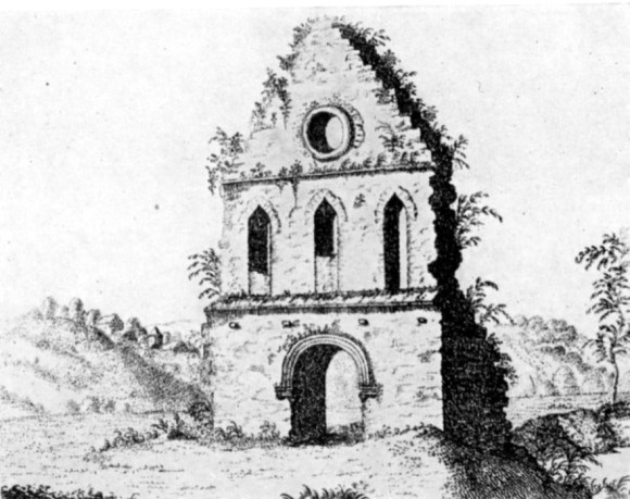
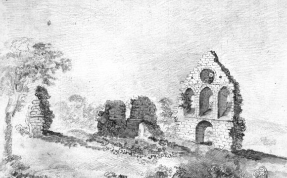
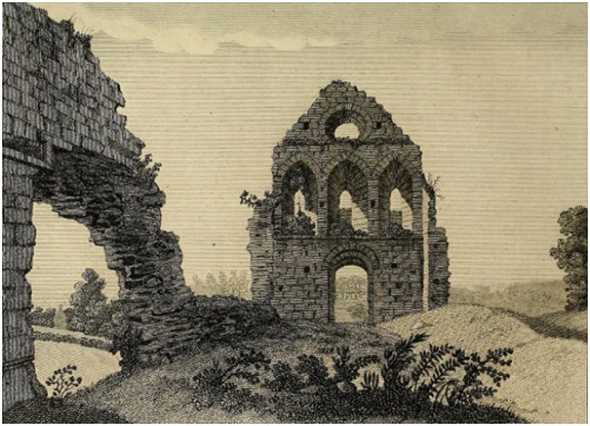
Thomas Livingston of Haining, the third son of Alexander, 5th Lord Livingstone, added a large wing to Haining Castle (Almond Castle) in 1586. The wing was relatively plain and the most likely source of the stone to build it was the derelict buildings at Manuel Nunnery. The Livingstones had no use for the monastic complex and probably also gave their tenants the privilege of carting dressed stone away from the site. Excavations there in 2007 found large robber trenches where even the larger foundation stones had been grubbed out from the ancillary buildings. The area was thus made suitable for ploughing and was incorporated into the fields. The church, however, was allowed to remain. This may in part have been due to its perceived sanctity and antiquity. For some reason the church building survived largely intact for a considerable period of time and a sketch from 1739 shows it almost entire apart from the roof. This suggests that not only was stone robbing forbidden, but that it must have been actively maintained and the building put to some use. Alterations that may relate to this period can be seen in later drawings. The lancet windows of the west gable were blocked up, at least in part, with narrow masonry. There is also a hint of a north/south division. Whilst the building may have been converted into a secular dwelling, as often happened, or even a barn, it is tempting to suggest that it continued as a church to serve the area. When Muiravonside Parish was disjoined from Falkirk in 1648 the Act stated that Muiravonside had been “separately served by a minister above 60 years gone,” that is to say shortly after the last days of the nunnery (Bailey 2009). Following the Disjunction a new parish church was constructed a little to the south of Haining Castle, on the site of the present one.
By 1739 the church building at the nunnery was isolated and roofless. In 1739 John Colquhoun got approval to remove stone
“from the ruinous monastery of Manuell useless to everybody but himself” (NAS: GD 220/5/1535).
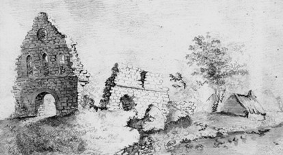
Once the wall-heads were open to the worst of the weather their structural integrity was threatened, cracks appeared and voids opened up. Subsequent sketches from the 1780s show that the building slowly deteriorated. The east wall with the large windows was the most vulnerable and presumably disappeared first. The north wall was evidently demolished, leaving a low mound of rejected material in its place and a stub against the west gable. Large holes opened up in the south wall and it developed a list to the south.
The nunnery lay just downstream from the ford, after which the waters were stilled by the incoming current from the Manuel Burn. This resulted in a bend in the river. Over the centuries the outside of the bend was being eaten away and we can be sure that whilst the nunnery was operational steps were taken to prevent this. Sibbald in 1707 says that the nunnery was on the “brink” of the river, implying that it was rather close. A hint that those river defences were failing comes from Johnston of Kirkland in 1723. He tells us that
“There is an Abbacy at Manual about a mile above Linlithgow bridge upon a low champain ground and close upon the north side of Aven, but now much washt away by the great speats or land floods, thats frequent in this water.” This is borne out by Nimmo in 1777: “The walls of the chapel, which are of hewn stone, are still to be seen, as also the burial place, a part of which is washed away by the river.” Then on 9-10 December 1787 “a dreadful spate came down the Avon and carried away the dam head at the Burgh Mill” and “destroyed the nunnery on a Sunday” (Papers of James Beveridge GD215/1870). “the flood swept away bit by bit the whole of the churchyard lying to the south and east of the Priory, and that an immense number of skeletons and a great many portions of coffins were swept down the river” (flysheet in book at West Lothian Archives).
In fact the river carved a secondary channel for itself to the north of the old one and this is shown on Forrest’s map of 1818 (A932.7 at Falkirk Archives shows eastern remnant of northern channel of the river). By the time of the flood the property was owned by William Forbes of Callendar House. He took immediate action to preserve both the monument and his land from further erosion, though creels filled with stone failed to stem the initial flow.
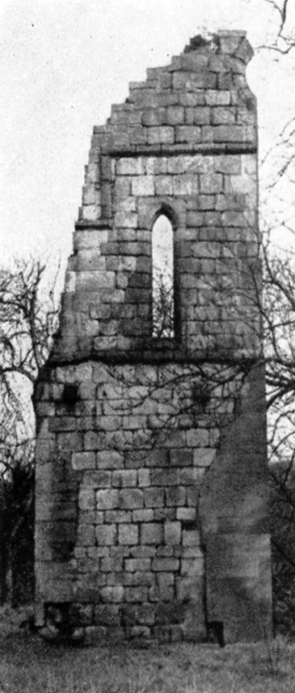
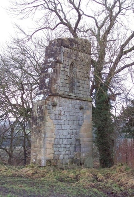
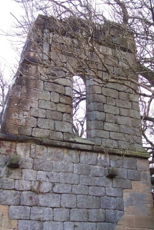
A flood bank of stone rubble was erected next to the old church and later extended eastwards. He then hired stone masons to support the remaining fragment of the west gable. Their stonework can be distinguished from the original because the sandstone brought in for the purpose is pinker in colour and contrasts with the grey of the old work. Only the northern side of the central doorway survived and this was supported by a stone buttress. The remaining column base at the doorway was carefully left visible. The consolidation followed much the same lines as used in modern conservation work and on 7 April 1789 the antiquarian, H Hutton, wrote to thank Forbes (GD171/357/3) and Grose included an acknowledgement in his publication. The remaining stonework has remained largely intact, though since 1952, when the RCAHMS photograph was taken, stone has fallen from the top and so the round window can no longer be seen.
The Church Building
WEST GABLE & MAIN ENTRANCE
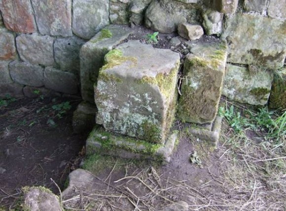
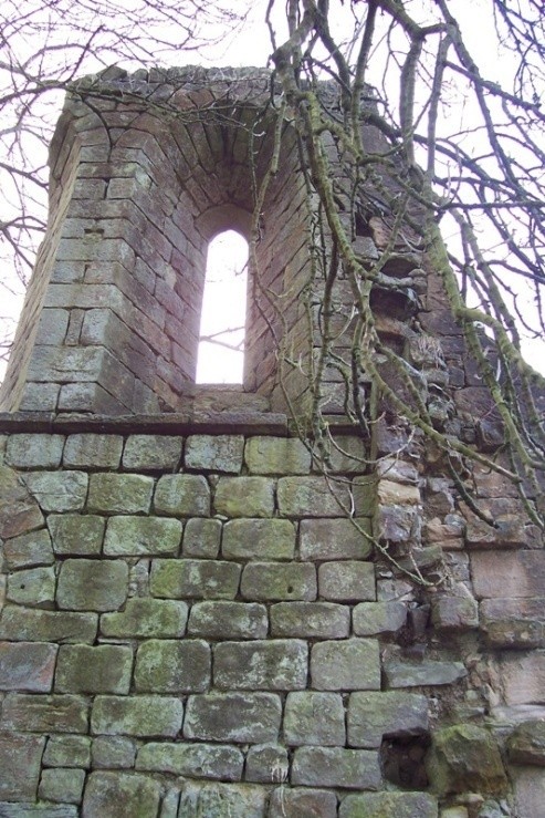
When looking at the design of the original church building it will be useful to start with a brief description of the remaining masonry which was part of the west gable. The gable is built of rough ashlar and is 4ft 1in thick. In the centre is a round-headed doorway; the moulded base of one of the nook-shafts remains. Above the level of the door are two corbels to support the roof-beam of a lean-to porch or galilee. Over these are the remains of two of the three pointed windows (only the north jamb of the central window surviving) jointed by a splayed sill course. Above the windows a square stringcourse is carried down at the north end of the gable. In the gable pediment was a round window, only a segment of which remained until recently. A fragmentary stump of the church’s north wall is attached. The gable is aligned almost due north/south, meaning that the building would have lain along a west-east axis (not SW-NE as stated in the RCAHMS inventory).
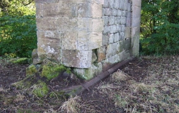
To this description we can add that there was a chamfered plinth course which was revealed by Laurie Alexander in 2008. This work, and that of the archaeological excavation in 2007, showed that the church facade extended to the north, joining a second building which was slightly offset.
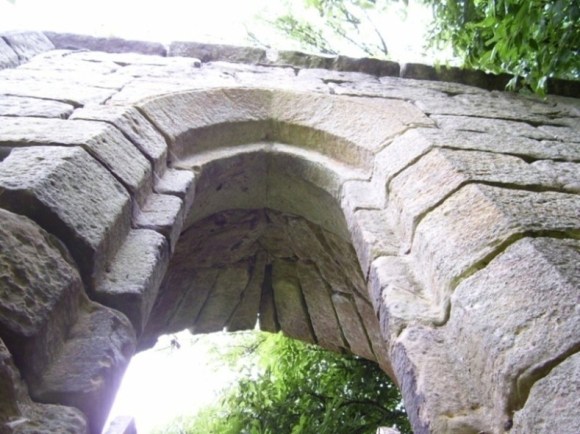
The doorway is shown in the antiquarian drawings with a nook-shaft or slender column set in a rebate on either side. The remaining moulded base is consistent with a 12th century date and was similar to one found at Kinneil Church.
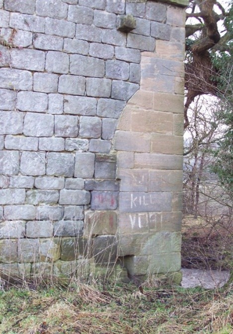
Five courses of masonry above the column base is the remnant of the moulded stringer for the archway. Although damaged, it can be seen that there was a narrow half round moulding below a similar larger moulding – reflecting those on the base (cf Auchindoir Church, Aberdeenshire).
.
The Romanesque archway itself was heavily moulded and inside there were receding arches. Above the door arch is a splayed sill course running the length of the gable. This is not a point of intake – though some of the antiquarian drawings make it appear thus. A little below this were four corbels with a recess on their upper sides to take a timber bearer which would have supported the rafters of a porch roof. The linear sill thus acted as a drip course for this roof.
The lancet windows above had chamfered margins with a rebate inside. Iron nails in the joints of the stone courses here would have retained the glass frame.
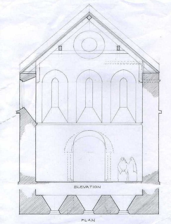
In the centre of the gable-head there has been a round window, part of the north margin of which can be seen in the 1952 photograph but its moulded stones are now on the ground. Like the lancet windows it too splayed towards the interior. Between the round window and the lancet widows there is another string-course, chamfered on both sides. It turns sharply downwards after passing north of the head of the lancet below, and then resumes the horizontal. This stepped aspect is poorly depicted on the antiquarian images, though it can just be picked out on one of the Gough drawings where it is at the very edge of the stonework. The surviving masonry suggests that this feature may have been partly reinstated during the 1789 reconstruction.
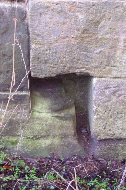
The rubble stud of the north wall is visible on the side of the gable indicating that this wall was only 3ft wide. Observation by Laurie Alexander noted that at its base was a rebated plinth with round mouldings along the top. The stones set upon this were larger than usual and better dressed suggesting a pilaster.
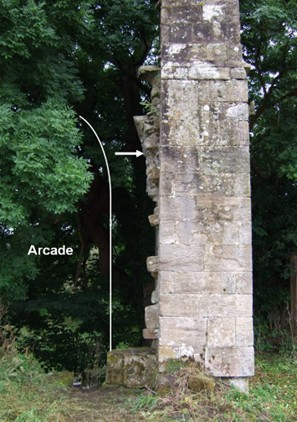
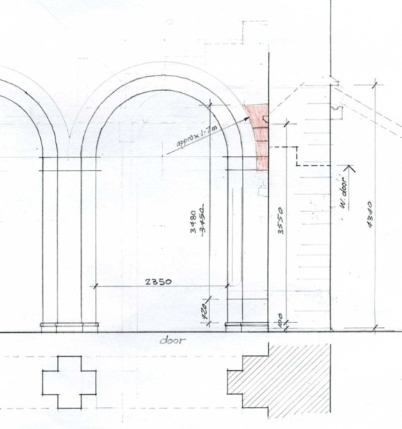
In fact, the arc of the upper masonry shows that this was part of a large archway which in this location must have been part of an arcading similar to that at the nunnery church of Iona. Clearly there was an aisle on the north side of the nave at Manuel and this accounts for the plinth course on the outside of the gable extending in that direction. The dimensions of the church suggest that this arcading would have consisted of three spans.
EAST GABLE & ALTAR
The church was built in the 12th century in the Romanesque style then in use, whereas Cardonnel’s redrawing of the 1739 image gives it the much lighter air of the later perpendicular style. It is immediately obvious that his skills as an observational artist were lacking as his presentation of the east gable is impossible and fails to take into account the impact of the north and south walls upon the huge three-light window there. We can, however, be sure that there was such a three-light window illuminating the chancel of the church. It would have been in the much heavier Romanesque style similar to that at Kilwinning Abbey.
The SOUTH WALL & GRAVEYARD
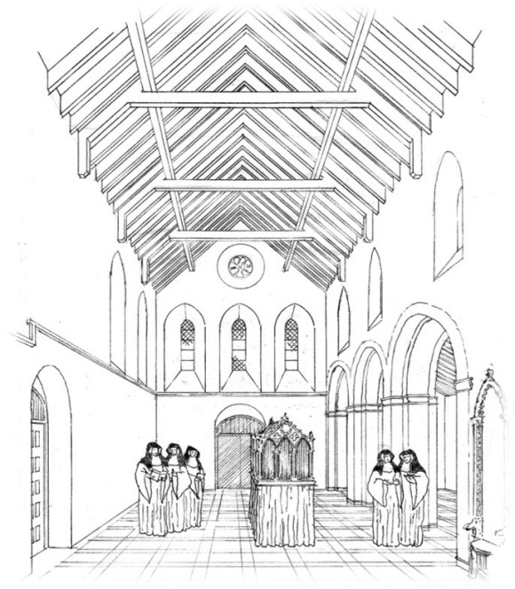
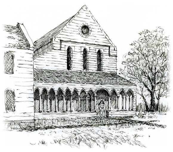
In reconstructing the church building we are fortunate in having the sketches of several antiquarians. Cordonnel’s redrawing of the 1739 image is the one which shows the south wall of the church most clearly. He has a large hooded central doorway similar to that of the west wall. This it has always been assumed gave access to a cloister on the south side of the church, as was usual. Gough shows the doorway from the interior at a later date by which time it appeared as an arched void. The 1739 image also shows two small lancet windows on the ground floor, each placed more or less equidistant from the doorway and the west and east corners. The position of the eastern one is important because it indicates that the protruding arched feature shown at the east end of the south wall was a later addition. Laurie Alexander has suggested that this may represent the alcove tomb of one of the prioresses. We know, for instance that that of Alice was said to feature a recumbent figure of her with a distaff. Usually such elaborate tombs are placed inside the church near the east end. It is unlikely that an ornate sculptural group such as a monument to a prioress would have been unprotected from the weather and the presence of two string courses along the lower section of the south wall indicate that a veranda was placed here, perhaps rounding the south-west corner to communicate with the narthex. Above the veranda roof the 1739 sketch shows four pointed-arched clerestory windows symmetrically disposed with a long gap in the centre of the wall. These are linked by another string course more or less at the level of their stringers.
All of this suggests that the 12th century cloister was indeed intended to be attached to the south of the church, between it and the river with the south range more or less on the bank. It is curious that the church should not have been built further to the north, on the slightly raising ground, to give it more prominence and to provide more space for the cloister. If the cloistral range had been completed on the south side of the church it would have been natural to build heavy flood defences to protect it against the encroachment of the water course. Perhaps an early movement of the river led to a change of mind, or to the necessity to move the auxiliary buildings to the north, where the robber trenches found in 2007 indicate that they lay.
The written accounts indicate that the later graveyard lay to the south and east of the church. This may have been initiated at an early date and would account for the position of the probable alcove tomb. This would have allowed an uninterrupted view of the church building from across the river. The graveyard was washed away in the 1787 flood when a large number of coffins and bones were swept downriver. Given the course that the new channel carved out, this could, however, mean that the graveyard was to the east of the church rather than the south. Cardonnel has placed a recumbent stone in the bottom right-hand corner of his drawing.
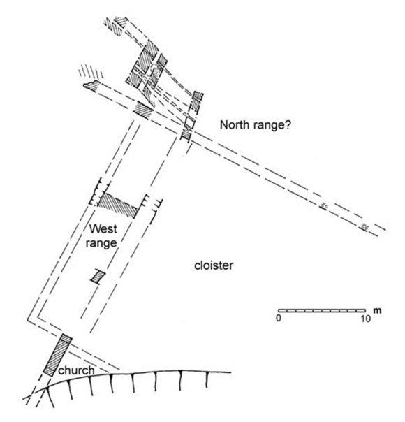
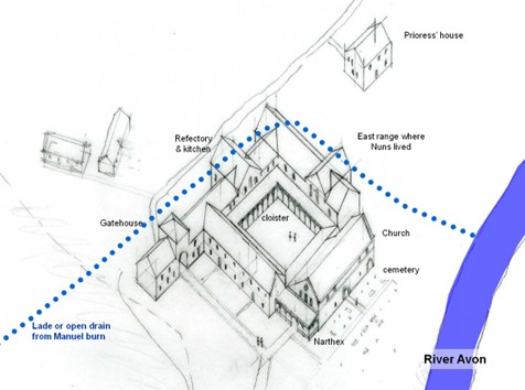
The CLOISTER and RANGES of BUILDINGS around it
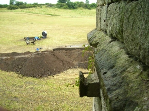
The layout of abbeys, monasteries and nunneries followed a similar pattern with an open courtyard or cloister along one side of the church. Dormitories, refectories and a chapter house stood on the other sides of the cloister. All of these would have been present at Manuel and their location depends upon that of the cloister. The excavations of 2007 by Geoff Bailey and his team indicated the presence of buildings to the north of the church. Two heavily robbed north/south foundation trenches 5m apart were believed to represent the west cloistral range. Further north a 1.2m wide wall foundation ran W/E for at least 38m, forming a terrace with extensive areas of cobbling to its N. Beyond that extensive plough damage had removed such surfaces. The wall and cobbling may be the remains of the north range, giving a cloister c26m square to the north of the church. Area ground resistance and magnetometry surveys of a larger area, 100m square, showed the W/E wall and high magnetic anomalies at the west end of the field.
Little pottery was recovered from the excavation and it became evident that the contemporary ground levels had been lost over a large area. The most likely reason for that was that the 1787 flood scoured the place. An extensive pattern of erosion channels can be seen on aerial photographs of this area when freshly ploughed. After the flood the area was cultivated and west/east rig and furrow lines appear on the resistance plot.
Fresh water for the nunnery complex would have been provided from the Manuel Burn rather than the River Avon. It would have been carried around the north end of the site so as to gravity feed the buildings. In its final course it would have cleaned out the drains of a lavatory attached to the dormitory block and deposited this in the river.
Perhaps the best preserved nunnery in Britain is at Iona which was founded in 1203 and there the cloister is 14m square. The church with its three-bay arcading looks quite similar to that at Manuel.
The Setting
.
Pont’s map of c1585 shows “Abbey Manwale” in the angle between the Manuel Burn and the River Avon. It had the same range of buildings as might be expected at an abbey. His pictogram shows a substantial building surrounded by smaller ones. To the north is another building set within an enclosure wall and this may have been the gatehouse. This northern building appears on two of Cordonell’s pictures from 1789 and on contemporary maps.
Roy’s map is of particular interest as it shows a road descending the slope of the escarpment from the gatehouse/farm of Manuel to the abbey on the haughlands below. The road then continues westward to Manuelburn Bridge, leaving a space between it and the nunnery church where the cloistral buildings once stood. The map also shows that there were buildings to the west of the church where the sewage works are now, and the thatched cottage of David Taylor to the east of the church which appears on one of Gough’s sketches.
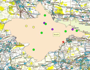
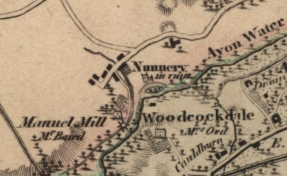
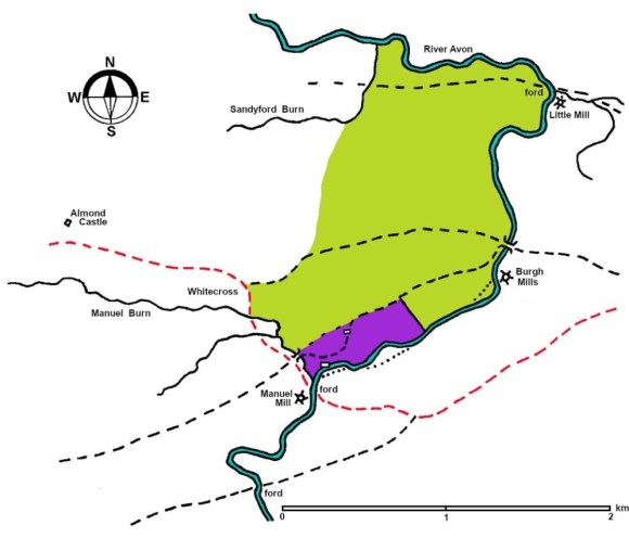
Manuel Farm also appears on Grassom’s map of 1817 where it is located to the south of the present road from Linlithgow Bridge to Muiravonside, placing it on the edge of the escarpment. The top of this escarpment would have been an appropriate setting for a precinct wall. All of the enclosure boundaries of the late 18th century in this area consist of hawthorn hedges sent on earth banks. The only exception to this is a boundary running south-eastwards across the haughlands from Manuelhaugh Farm. This is not only a stone dyke but is well-made of quarried stone. Its incongruity suggests that it was the east boundary of the precinct. The western boundary would have been the Manuel Burn.
Illus: Grassom’s Map of 1817 (National Library of Scotland).
To the west of the burn was a road running from Manuel Mill up to Manuelburn Bridge and on to Whitecross. This was probably part of the main road from Linlithgow to Falkirk. It was joined at Manuelburn Bridge by the road from the priory.
The lands owned by the nunnery in the area were more extensive and Reid provides us with a map showing the probable location of the estate (Reid 1994, 39), which is used on the map below.
The Antiquarians
Four antiquarians are particularly associated with Manuel Nunnery:
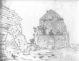
Richard Gough (1735-1809)
– Became a fellow of the Society of Antiquaries of London in 1767. It is assumed that he visited the site c1776 when his drawings were made. He was a prolific correspondent and conversed with most of the leading antiquarians of his day who sent him their observations. In our area this was particularly the case with regard to the Antonine Wall and Arthur’s O’on. Using this information he revised Camden’s “Britannia.” His collection was left to the Bodleian Library, Oxford, where it was used by Cardonnel.
The sketches were done by eye and lack the rigorous architectural perspective of Hutton. They are nonetheless reliable and the views selected were intended to give a good overall idea of the remains. They are distant views and this resulted in some foreshortening of the ground floor features.
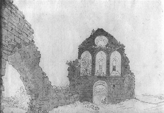
George Henry Hutton (c.1760-1827)
– A career soldier often in Scotland, he wrote to William Forbes in 1789 requesting information on the nunnery. His illustrations show that he used a camera obscura on site and obtained accurate and detailed representations of elements of the building.
We have three versions of his image taken from the east end of the church looking to the main entrance and these demonstrate his methodology. He started by using the camera obscura to draw the outline of the west gable and then to fill in the individual stones. Then he broadened out the sketch by adding the remains of the south wall by eye, failing to capture the true perspective. The result was a simple pen and ink line drawing. Back home he worked this sketch up by correcting the perspective of the south wall in relation to the gable. He then added a light wash to highlight the lumps of masonry and suggest shadow. In a third and final version he varied the wash to give the image a more three-dimensional appearance with more variable light and shadow. Some detail was picked out and appropriate vegetation added for balance.
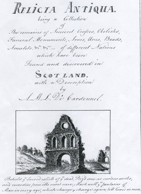
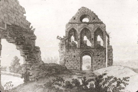
Adam Mansfeldt de Cardonnel (1746-1820)
– Trained as a surgeon but family wealth allowed him to pursue his passion for antiquities. He published a book in 1788 called the “Picturesque Antiquities of Scotland.”
His views of Manuel Nunnery have become the iconic ones and are shown in the history section above. He copied earlier drawings and clearly misunderstood some of the architecture. Despite that the image of the church that originated in 1739 is the only one to show the building before the dismantling process began. It is highly probable that he added the recumbent gravestone in the lower right-hand corner. He also clarified some of the features, such as the corbels, on Gough’s drawings of the west gable, showing that he had visited the site in person.
Francis Grose (c.1731-1791)
– A former army officer, he travelled in Scotland in 1788-1790. He studied art and illustrated his own books and produced a two-volume set called “Antiquities of Scotland” which concentrated on medieval castles and abbeys. He met Cardonnel in 1789.
Bibliography
| Bailey, G.B. | 1996 | ‘The Graveyards of the Falkirk District: Part I,’ Calatria 9, 1-34. p.89-97. |
| Bailey, G.B. | 2009 | ‘The First Parish Church at Muiravonside, Calatria 25, 55-59. |
| Bertram, J. | OSA | Parish of Muiravonside; The Statistical Account of Scotland. “There ftill remain fome ruins of an old abbey, called Manuel, on the fide of the Avon, about half a mile above Linlithgow bridge. It was built in the 12th century” [p.564] |
| Crawford, G. | 1738 | History of Linlithgow. |
| Gillespie, R. | 1879 | Round about Falkirk. (Quoted at (1) below) |
| Grose, F. | 1789 | The Antiquities of Scotland.(p.67) “THE NUNNERY OF EMANUEL, OR MANUEL.(Quoted at (2) below) |
| Jaques, R. | 2001 | Falkirk and District, an Illustrated Architectural Guide, p.141-7. “Manuel Nunnery, 12th century. Buttressed fragment only of Cistercian nunnery founded by Malcolm IV, on the banks of the Avon, which has altered its course considerably over the years. Drawing of 1731 in Bodleian Library shows plane roofless rectangular building with one circular and three pointed windows in the extant gable.” [p.106] |
| Leask, D. | 2017 | A Historic Tour of the Parish of Muiravonside. p.243. |
| Macfarlane | 1723 | Macfarlane’s Geographical Collections: Johnston of Kirkland 1723: “There is an Abbacy at Manual about a mile above Linlithgow bridge upon a low champain ground and close upon the north side of Aven, but now much washt away by the great speats or land floods, thats frequent in this water.” [p.317] |
| Nimmo, W. | 1777 | p121-123. “The Nunnery of Emmanuel, of Manuel (Quoted at (3) below. |
| RCAHMS | 1963 | Stirlingshire: An Inventory of the Ancient Monuments. p.9, 155 (Quoted at (4) below) |
| Reid, J. | 1994 | ‘The Feudal Land Divisions of East Stirlingshire,’ Calatria 6, 79-110. |
| Reid, J. | 1994 | ‘The Feudal Land divisions of Muiravonside Parish: the Principal Subdivisions,’ Calatria 7, 21-85. |
| Sibbald, R. | 1707 | 28 : “There is also in this Shire the Nunnerie of Emanuel, of the Nuns of the Cistercian Order, it is situate upon the brink of the water of Avon, in a pleasant Countrey, and founded by King Malcolm the Fourth. It lyes within the Parish of Moranside.” |
- Gillespie, R. 1879 Round about Falkirk.
“For the old Priory we must proceed up the Avon to the vicinity of Manuel (Emmanuel) village. The ruins, consisting simply of a portion of the western gable wrapt in a thick wood-warp of ivy, stand on the north bank of the river, in a haugh on the farm occupied by Mr Inglis. The fragment, which is of hewn-stone, and elegant in its simplicity, contains an arched door, or gateway, with three small gothic windows over it; and above these a circular one is placed. In 1739, however, the “chapel” was comparatively entire. There was the eastern gable perfect in form, with a high triple-arched window; also the south wall, which, in addition to a central door, had another close to the eastern gable, with three windows overhead. And it is said part of the south wall of the church was standing until the beginning of 1788, when, the river having risen to an unusual height, it was swept away by the violence of the flood with part of the bank that had been used as a cemetery. Luckily, we have all the facts at hand regarding the history of the local relic of monasticism, and therefore need not be reminded, by way of caution, of the famous praetorium of old Monkbarns. The Manuel cemetery, as we find from reliable relics, were founded by Malcolm IV. in 1156, and consecrated to the Virgin Mary. It was possessed, too, originally by Cistercian nuns – an order that derived its name from a district in Burgundy called Citeaux, where the first convent of that austere school was founded by St. Robert, but, which, of course, was simply an offshoot of the great Benedictine epoch. In 1292 the Prioress Christina swore fealty to Edward I., who, as we learn from a writ of his own, visited “Manewell” on the 24th October,1301. Alice, Christina’s successor, also swore fealty to Edward, at Linlithgow, in 1296. Her tomb was to be seen here, some years ago, bearing her figure with a distaff – an unusual instrument in the hands of a princess. The nunnery had possessions in the shires of Edinburgh and Ayr, as well as those of Linlithgow and Stirling; and when the list of ecclesiastical revenues was drawn up in 1562, those of Manuel amounted to fifty-two pounds fourteen shillings and eightpence Scots, three chalders of bere, seven chalders of meal, with a large quantity of salmon. The graveyard lay immediately beneath the nunnery, close upon a slight bend of the river; but for years the water current has been incessantly washing away the very foundations of the monastic burial-ground. [p283/284] - Grose, F. 1789 The Antiquities of Scotland.
(p.67) “THE NUNNERY OF EMANUEL, OR MANUEL.
This nunnery is situated on the borders of Stirlingshire, upon the Weft bank of the water of Avon, about a mile above the bridge of Linlithgow, in the parish of Moranside or Muiravonside. It was founded about the year 1156 by King Malcolm IV surnamed the Maiden, and was a priory occupied by nuns of the Bernardine or Cistertian order, to whom belonged thirteen convents in Scotland.
- Besides the endowments bestowed by the royal founder, it received considerable donations from others at different periods. King William, surnamed the Lion, made a grant of the tenth of all his revenues in the shire and borough of Linlithgow, both money and victuals. Alexander II. made a donation of the mills of Linlithgow, with all their sequels and appurtenances; and Roger de Avenel bestowed on the holy sisters a chalder of wheat, to be paid by him and his heirs, out of his barns of Abercorn, at Christmas, yearly.The prioress of this place, whose name was Christina, swore fealty to Edward I. July 4, 1292, * as did her successor, named Alice, at Linlithgow, in 1296. **
This nunnery had possessions in the shires of Edinburgh and Ayr, as well as in those of Linlithgow and Stirling, as appears by an order of Edward, to the Sheriffs of those shires, to reinstate the prioress in possession of her land, within their several jurisdictions, in consequence of her having sworn fealty to that Monarch.
When the list of ecclesiastical revenues was drawn up in 1562, those of Emanuel amounted to fifty-two pounds, fourteen shillings, and eight-pence Scots, three chalders of bear, seven chalders of meal, with a large quantity of salmon. ***
Of this nunnery little remains, except the West end of the church. This fragment contains an arched door or gateway, with three small (p.68) Gothic windows over it, and over these a circular one. This structure is of hewn stone, but unadorned; yet there is an elegant simplicity in it, and, with the beauty of the surrounding objects, it makes a very picturesque appearance. Part of the South wall of the church was standing still till the beginning of the year 1788, when the river having risen to an unusual height, it was swept away by the violence of the waters, with part of the bank, used as a cemetery. William Forbes, Esq. of Callendar, the proprietor, caused the bank of the river to be repaired, which will probably protect these remains from further injury.
This monastery came into the hands of the crown by the forfeiture of the Earl of Callendar and Linlithgow, to whose predecessor it had been given some time after the Reformation. Near this nunnery, but .on the opposite side of the river, lies the field where the battle was fought between the Earls of Lenox and Angus, during the minority of James V. in which the former was defeated and slain. Sir Robert Sibbald, in his History of Stirlingshire, says, near to Emanuel some curious capellaries are found. — Emanuel is a Hebrew word, signifying God with us. It is said the tomb of the prioress, Alice, was to be seen here a few years ago, upon which was her figure, with a distaff; an uncommon instrument to be put in the hands of a prioress.
[This was drawn in 1789.]
* Rymer’s Foedera, tom. 2. p. 572.
** Keith on Religious Houses.
*** Keith’s Appendix.”
- Nimmo, W. 1777 p121-123.
“The Nunnery of Emmanuel, of Manuel. This nunnery was situated in the very borders of Stirlingshire, upon the north bank of the river Avon, a mile above the bridge of Linlithgow. The walls of the chapel, which are of hewn stone, are still to be seen, as also the burial place, a part of which is washed away by the river. It was founded by Malcolm IV surnamed the Maiden, in the year 1156, and consecrated to the Virgin Mary. It was possessed by nuns of the Bernardine, or Cistertian order, to whom belonged thirteen convents in Scotland. Besides endowments bestowed by the royal founder, it received considerable donations for others, at different periods. King William, surnamed the Lion, made a grant of a tenth of all his revenues in the shire and borough of Linlithgow, both money and victual. Alexander II made a donation of the milns at Linlithgow, with all their sequels and pertinents; and Roger de Avenel bestowed upon the holy sisters a chalder of wheat, to be paid by him and his heirs, out of his barns of Abercorn, at Christmas yearly.
The prioress of this place, whose name was Christina, swore fealty to Edward I. July 4, 1292, * as did her successor, named Alice, at Linlithgow, in 1296. ** This nunnery had possessions in the shires of Edinburgh and Ayr, as well as in those of Linlithgow and Stirling, as appears by an order of Edward, to the Sheriffs of those shires, to reinstate the prioress in possession of her land, within their several jurisdictions, in consequence of her having sworn fealty to that monarch. When the list of ecclesiastical revenues was drawn up in 1562, those of Emanuel amounted to fifty-two pounds, fourteen shillings, and eight-pence Scots, three chalders of bear, seven chalders of meal, with a large quantity of salmon. *** After the Reformation it was given to the family of Callander.” - RCAHMS 1963 Stirlingshire: An Inventory of the Ancient Monuments. p.9, 155
“The Nunnery stood on the left bank of the Avon 100 yds downstream from the inflow of the Manuel Burn, and the more easterly part of the site has now been entirely washed away by the river, as were the S. side-wall and the cemetery in 1783 (1 – Grose, F. The Antiquities of Scotland, ii (1797), 236 (mis-paged 263). All that remains of the Nunnery buildings today is the N portion of the W gable of the church (2 – actually the orientation must have been nearly NE and SW), but a drawing of about 1739 (Cardonnel, A, Picturesque Antiquities of Scotland (1788 ed, 74) shows the church as still entire, although roofless. It appears to have been a small rectangular block with no structural division between nave and chancel; the E wall was pierced by three large windows with pointed heads. The cloister seems to have been on the S, entry being obtained by a doorway centrally placed in the S wall of the church.
The surviving fragment is built of large squared blocks of grey freestone, laid in courses. Its lower part contains the N side of the central entrance, now filled up by a patch; on the inner face of the wall the three lowest voussoirs of the arch can still be seen, and on the outer side the base of a small column, the moulding of which suggests a date in the 12th century. On the N this gable wall, which is 4 ft 1 in. thick, finished in a buttress which projects 1ft 3in from the line of the demolished N side-wall of the building which is only 3ft thick. The original breadth of this gable, over both buttresses, was probably about 22ft to 23ft. At an upper level the gable was pierced by three lancet-windows (this drawing was made by Cardonnel in 1789), the northernmost of which is entire and shows widely chamfered margins; its head is cut out of a single block and is outlined by a fine groove, and within it is widely splayed. The N jamb of the central lancet can also be seen, with its internal splay on the line of the vertical S edge of the surviving structure. Below the sills of the windows there runs a splayed intake-course, and just below this there project two corbels, notched on their upper surfaces to carry the supporting beam of the roof of a former W Galilee, all other trace of which has now disappeared. In the centre of the gable-head there has been a round window, part of the N margin of which is still preserved; below this there is another string-course, which turns sharply downwards after passing N of the head of the lancet below, and then resumes the horizontal. The inner side of the gable can be seen in an 18th century illustration, now in the Bodleian Library, which is reproduced in Pl.36D.
Manuel, a house of Cistercian nuns, was founded by Malcolm IV before 1164, the endowment being confirmed by William the Lion a few years later. Little is known of the history of the Nunnery or of the extent of its possessions, but the house was not wealthy and the community may always have been a small one. It is known that Edward III recompensed the convent for damage caused by his army on its march towards Perth in the summer of 1335 (6 – Wardrobe book, British Museum, MS Cotton, Nero C. viii, fo. 274; Cal of Docts, iii, No 1186.) In 1506 a petition of James IV for the suppression of the house, on the ground that the nuns were scarcely five in number and led a life alien to the Cistercian rule, was granted, but it was evidently not put into effect as a prioress ad four nuns were still in residence in 1552 (7 – this account follows that of Easson, Religious Houses, 123).
971763 NS 97 NE (unnoted) 6 March 1853.”
Archival Material
Inscription on flysheet of book in West Lothian Archives, Blackburn. “The Rev Dr Andrew bell of Linlithgow told me in 1854 that the Rev Mr McCall of Muiravonside had told him of the destruction of the Priory of Manuel in 1787 and that the flood swept away bit by bit the whole of the churchyard lying to the south and east of the Priory, and that an immense number of skeletons and a great many portions of coffins were swept down the river. He said that many of the Nuns belonged to the oldest best families on Scotland; and that Jean Livingstone, a relative of the Earl of Linlithgow, was one of the Prioresses.
Papers of James Beveridge GD215/1870. 10.12.1787: On Sunday the 9th & 10th December 1787 a dreadful spate came down the Avon and carried away the dam head at the Burgh Mill. The late Mr Alexander Addison, farmer, Kipps, told Mr Russell that he had heard as a boy that the flood destroyed the nunnery on a Sunday.
Letter from Rev R Couper, The Manse, Linlithgow: “My dear Sir, What you mentioned the other evening about you having heard that the River Avon once ran to the north of Manuel Nunnery… leads me to say that from authentic original survey plans, the following facts were established, viz:- (1) William Forrest’s map of Linlithgowshire, published 7.8.1818, shows a bifurcation of the river, commencing just opposite the nunnery, … distance of 10 chains Scots, thus making a small island in the middle of the river… 2 & 1/2 acres. The channels are shown to be of about equal size… (2) The same surveyors [plan of Woodcackdale… 1822], shows same fork, but south channel is only 1/2 size of north. This can be relied upon as the scale is sufficiently large to accentuate the difference correctly, (3) Feu plan of Woodcockdale estate by Thomas Carfrae in 1845 still shows the bifurcation island and channels as in 1822. The south channel has therefore got silted up or has been filled in since 1845. Now as this little island formed part of the Callendar Estate, and is still held Feu… deduction can be made that the south channel was originally either the only one or principal channel and that the north channel next nunnery was either non-existent or subsidiary. …It may be further speculated that the flood of 1787, which wrought such ravages, may also give the correct date for the north channel becoming the principal channel… Herman Moll’s map of Stirlingshire, 1725, shows Manuel Abbey on the north side – no bifurcation.
National Archives of Scotland
[H Hutton of Kelso to William Forbes of Callendar House, Falkirk. GD171/357/3]
Kelso, April 7th 1789 Sir, As I am endeavouring to procure all the information I can relative to the monasteries and other ancient religious establishments of the kingdom, I beg leave therefore to take the liberty of troubling you with a letter, to request you will honor me with such particulars as you may be acquainted with, and think proper to communicate, respecting the nunnery of Manuel or Emanuel.
If a copy of the chartulary, and an impression of the conventual seal could be procured, they would be of infinite use in the line of my enquiries: I have never been able to learn with any degree of certainty whether those articles are extant. Probably the charter-chest of the burgh of Linlithgow might produce something satisfactory, both with respect to this monastery of nuns, and the Carmelite friars of Linlithgow, concerning whom any information would likewise be extremely acceptable.
Very few circumstances respecting the nunnery of Manuel are mentioned by the writers upon religious houses: and so I have only been able to discover the names of two of the prioresses in the course of my reading: a compleat succession would be highly satisfactory indeed: If the chartulary is extant, no doubt many of them will be there preserved.
I am very happy sir, that you have so well protected this beautiful and venerable ruin against the encroachments of the river, and I hope it may yet see many years under such a proprietor. I have given Capt. Grose a view of the remains, for his antiquities of Scotland; the drawing was made before the south wall was destroyed.
I am ashamed to think of giving a gentleman so much trouble to whom I am entirely unknown, but I trust from the peculiar nature of the enquiry, you will have the goodness to pardon the freedom I have used, and the omission I am guilty of, in not having previously obtained the honor of an introduction to you….
Archives; Falkirk Museums; Callendar House “There is in particular in Manuel a remarcably fine large haugh, which I would think a good estate without any more ground, it is to the east of the abbey from which all the grounds there have there names, the grounds belonging to the house of God, Manuel being a corruption of Emmanuel. Emmanuel house or abbey spoke of by Buchanan is a very old thing and the piece which stands and should have leave to stand is pretty. The abbey is not Almond Castle but a consecrated and once famous house near to it.” [GD172 f23]
Archives; Falkirk Museums; Callendar House GD266/119/17/1 Bundle 1: Misc papers regarding the course of the River Avon 1817-19. Blair of Avontoun.
National Archives of Scotland CS96/3842 Alexander Stevens snr, architect, Edinburgh, memorandum book 1794, 1799.
National Archives of Scotland: Survey from Linlithgow Bridge to Emanual Abbey with part of the lands of Avontoun and Almond & c in reference to a report by Robert Stevenson civil engineer, 1816. [Forbes Archives]
Archives; Falkirk Museums; Callendar House: Plan of part of the River Avon, March 1816. John Lauder. [Forbes Archives]
Geophysical Survey at the site of Manuel Nunnery, Falkirk District; Mr Dave Jones; 2008; Occasional Paper No. 17.
Discovery & Excavation in Scotland 2008. New Series Volume 8, 94.
Manuel Nunnery. Geoff Bailey. 12th century nunnery (NS 971 764). Excavation to the N and E of the surviving 12th century gable of the nunnery church at Manuel found two N/S robber trenches 5m apart, which are believed to represent the W cloistral range. Further N a 1.2m wide wall foundation ran W/E for at least 38m, forming a terrace with extensive areas of cobbling to its N. Beyond that extensive plough damage had removed such surfaces. The wall and cobbling may be the remains of the N range, giving a cloister c26m square to the N of the church. Antiquarians believed that the cloister lay to the S of the church, as is more usual, and that it had been washed away when the River Avon changed its course in the 18th century.
Area ground resistance and magnetometry surveys of a larger area, 100m square, showed the W/E wall and high magnetic anomalies at the west end of the field. W/E rig and furrow lines appear on the resistance plot.
Site archive: Falkirk Museum. Sponsors: Falkirk Local History Society Edinburgh Archaeological Field Society Dr Peter Morris Historic Scotland
National Monuments Record for Scotland.; RCAHMS;
“All that now remains of the buildings of Manuel Nunnery is the north portion of the west gable of the church. The more easterly part of the site was apparently washed away by the River Avon, as were the south side-wall and the cemetery in 1783. A drawing of about 1739 (Cardonnel 1788, 74) shows the church as still entire, though roofless. The cloister seems to have been on the south, entry being obtained by a doorway in the middle of the S wall of the church (RCAHMS 1963, 155). Architectural details suggest a 12th century date for the building. Manuel, a house of Cistercian nuns, was founded by Malcolm IV before 1164. Little is known of its history or possessions, but the house was not wealthy and the community may always have been a small one. A prioress and four nuns were in residence in 1552. RCAHMS visited site in 1953 (RCAHMS 1963, 155). The remains of the nunnery were as described, when visited by OS on 10 January 1974. Magnetometry and area ground resistance measurements were made over an area of 100m by 100m in a field to the north east of the remaining section of the nunnery church that stands beside the River Avon two miles to the south west of Linlithgow. There is record of building in this field and the surveys were made to inform an excavation (Bailey 2007, 94) that was made in parallel with the survey. Resistive and magnetic printouts correlated well but neither showed outlines that could be interpreted as the remains of rectangular buildings. Curving areas of enhanced magnetic response are mostly related to matching areas of raised resistance and could represent varying drainage channels in the drift geology. Linear high resistances, that enter the area from the south west just to the north of the church wall, were early candidates for excavation and were found to be cobbled surfaces and probable wall footings. Relief plots of the resistance survey show rig and furrow cultivation over the whole area with furrows curving to conform to the line of the bank of the River Avon; this plot also shows a possible structure, at the north east corner of the survey, adjacent to a spring. A magnetic anomaly line, that cuts from the north-west side of the survey to the middle of the south side is not matched by a resistive feature and may be the infilled line of the leat from the Manual Burn into the River Avon. Excavation to the north and east of the surviving 12th century gable of the nunnery church at Manuel found two north/south robber trenches 5m apart, which are believed to represent the west cloistral range. Further north a 1.2m wide wall foundation ran west/east for at least 38m, forming a terrace with extensive areas of cobbling to its north. Beyond that extensive plough damage had removed such surfaces. The wall and cobbling may be the remains of the north range, giving a cloister c.26m square to the north of the church (Bailey 2007, 94). Antiquarians believed that the cloister lay to the south of the church, as is more usual, and that it had been washed away when the River Avon changed its course in the 18th century (Bailey 2007, 94). There is an archive record, within the papers of the Graham Family, Dukes of Montrose, of the removal of stone from the Monastery of Manuell, in which John Colquhoun, clerk of regality of Glasgow in a letter to Mungo Graham of Gorthie encloses memoranda anent taking stone ‘from the ruinous monastery of Manuell useless to everybody but himself’ (NAS: 1741 GD 220/5/1535).
Statutory List: Buildings of Special Architectural or Historic Interest; Historic Scotland;
“Ruined fragment. North portion of west gable of 12th century church: Inv 144 Notes: Stone recently dislodged (1970).”
