SMR 326 / NS 856 734 / Scheduled
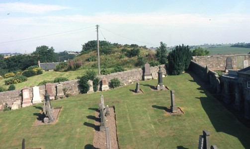
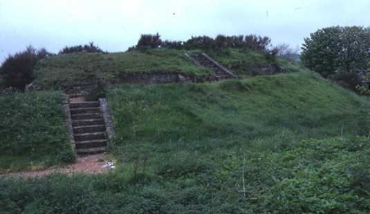
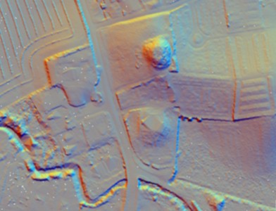
The motte at Slamannan is located on the small strip of rising ground separating the River Avon from the Culloch Burn to the south. It now appears as a truncated cone measuring about 13ft in height, 90ft in diameter at the base and 37ft across the summit. Since the 18th century it has suffered a good deal of disturbance. In 1723 Johnstone of Kirkland wrote “upon the north side of the Kirk is a little green hill called the mote which appears to be artificially made, but upon what design is not known” (MacFarlane 1906).
Mottes were built throughout Scotland in the 12th and 13th centuries as strong points for the feudal lords.
In 1642 an act of sasine was performed at “Wellhill of Balmulzier,” suggesting that the old motte site was still being used as the locus for legal transactions and that there was no principle house in the area to replace it (Reid 2010, 70). It was referred to as “Mothall” in 1659 when George Weddell, portioner of Balquhatstane, acquired “all and haill the lands of South Balmilliar and the lands of Mothall with the manner place houses [etc] — pertained – of before to the deceist Johne Rankine of Southhouse of Balmiliar” (Reid Notes). By 1723, as we have seen above, it was simply “the mote” and “the moat” in 1793 (OSA).
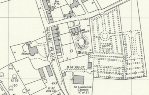
Excavations were conducted by Doreen Hunter in 1958 with the help of the local Scout troop. The northern half of the top of the mound was excavated, but no clear evidence of any structure was found. Two sections were also cut across the ditch, and pottery sherds were obtained from the primary silt in each. Hunter suggests that they were 13th century (Hunter 1958, 37), but the green-glazed pottery retained by the owners of Balquhatstone House is green-glazed ware from the 16th century and later (Falkirk Museum 2021-7-1&2). No details were given of the size of the ditch and it is not known where the sections were cut. Given the presence of buildings nearby, it seems probable that they were on the north-east and south-east radii of the mound. Nearby housing became “Moat Terrace” and “Moat Cottage.” The ditch had been completely infilled by the time that the 1860 Ordnance Survey map was surveyed and the buildings and gardens came almost up to the foot of the mound.
A short piece in the Falkirk Herald of 14 October 1911 mentions the discovery of a sword by the tenant of Balmulzier Farm. Whilst the motte lay within the grounds of the farm it is unlikely that the sword was actually found there. However, William Meek, who lived at the adjacent dwelling, later came upon a spur and this clearly came from the immediate area of the motte. It is most probable that the spur was 17th century or later. Finally, the article on the motte mentions that “human remains have also been found in cavities on its sides”. No details are available concerning the nature of these remains.
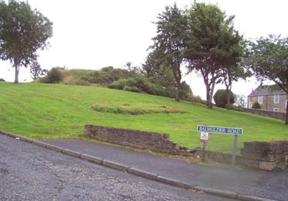
During the Second World War the local Home Guard mounted a machine gun on the hill to cover the river crossing and the road from Falkirk. The adjacent houses were demolished in the late 1960s as part of the county council’s slum clearance scheme and the land was acquired to create the present park.
The Old Statistical Account of the parish written in the 1790s states that “there were anciently here, 2 cones of earth, about 50 yards distant from one another, which are supposed to have been raised as monuments of peace, like the 2 at Dunipace; the one of them still stands, and is evidently artificial; the other was levelled, and the church of St. Laurence built upon it”.
The minister must have been reporting a tradition as well as making his own judgement of the topographical setting. At the time the old church was still standing and the hill upon which it stood was more prominent than now, having been further truncated by the rebuilding of the church in 1810. This second mound would have been used as part of the bailey of the castle and its former enclosure is reflected in the curved south wall of the later churchyard. A similar situation occurred at Dunipace.

The motte sits on one of a series of small hillocks that extend across the river’s floodplain from the south. At this point there is a projecting bluff on the north side, creating a convenient line of north/south communication across an otherwise marshy river valley. For this reason the church and village of Slamannan lie on the northern perimeter of the parish.
Bibliography
| Bailey, G.B. | 2003 | ‘The Graveyards of Falkirk District Part 8; Slamannan,’ Calatria 19, 1-56. |
| Hunter, D.M. | 1958 | Discovery and Excavation in Scotland. p37. (Quoted at 1 below) |
| Jaques, R. | 2001 | Falkirk and District, an Illustrated Architectural Guide. (Quoted at 2 below) |
| Walter MacFarlane | 1906 | Geographical Collections Volume 1 (Quoted at 3 below) |
| Macnair, J. | 1795 | ‘Parish of Slamannan, or St Laurence, ’ Old Statistical Account; County of Stirling. |
| RCAHMS | 1963 | Stirlingshire: An Inventory of the Ancient Monuments. (Quoted at 4 below) |
| Reid, J. | 2010 | ‘The Feudal Divisions of East Stirlingshire: Slamannan Parish,’ Calatria 26, 65-78. (Quoted at 5 below) |
| Simpson, G. | 1972 | Charter Evidence and the Distribution of Mottes in Scotland, p175-92, no.226. |
| Waugh, J. | 1977 | Slamannan Parish through the Changing Years, 9-12. |
| Ordnance Survey Archaeology Sheets (2 of, quoted below) | ||
| Falkirk Herald | 1911 | 14 October, page 4 (Quoted at bottom of page) |
- “The “Mote” of Slamannan stands on a small rising ground which separates the River Avon from its tributary the Culloch Burn, on the N outskirts of the village. In ancient times the adjoining low-lying fields may well have been a marsh. The motte is reached through a door in the N wall of the graveyard, and now appears as a truncated cone measuring about 13ft in height, 90ft in diameter at the base and 37ft across the summit. It has suffered a good deal of disturbance, a path and brick steps having been made on its E slope. In 1958 the N half of the top of the mound was excavated, but no clear evidence of any structure was found. Two sections were also cut across the ditch, and sherds believed to be of 12th- or 13th- century date were obtained from the primary silt in each. The Ordnance Survey Name Book implies that until 1810 another mound existed close by, on the site of the parish church.”
- “12th century. Raised mound north of the church all that remains of medieval motte and bailey. Excellent views of village and surrounding countryside. [p.109]
- “There has been an old fortifications a little South of the Kirk of which there remains very little vestige, but is commonly called the Castle hill, and opposite, to it upon the north side of the Kirk is a little green hill called the mote which appears to be artificially made, but upon what design is not known. There is a burn runs by the Kirk called Castlehill burn, and has a bridge thereon of one arch.”
- “The “Mote” of Slamannan stands on a small rising ground which separates the River Avon from its tributary the Culloch Burn, on the N outskirts of the village. In ancient times the adjoining low-lying fields may well have been a marsh. The motte is reached through a door in the N wall of the graveyard, and now appears as a truncated cone measuring about 13ft in height, 90ft in diameter at the base and 37ft across the summit. It has suffered a good deal of disturbance, a path and brick steps having been made on its E slope. In 1958 the N half of the top of the mound was excavated, but no clear evidence of any structure was found. Two sections were also cut across the ditch, and sherds believed to be of 12th- or 13th- century date were obtained from the primary silt in each. The Ordnance Survey Name Book implies that until 1810 another mound existed close by, on the site of the parish church. 856734 NS 87 SE(“Mote”) 20 July 1959.” [No. 179, p.173].
- In 1642 an act of sasine was performed at “Wellhill of Balmulzier”, suggesting that the old motte site was still being used as the locus for legal transactions and that there was no principle house in the area to replace it. [p.70]
Ordnance Survey Archaeology Sheet (1)
“The motte at Slamannan situated immediately north of the graveyard, now appears as a truncated cone measuring about 13′ high, 50′ diameter at base, and 37′ across the summit. It has suffered a great deal of disturbance, a path and brick steps having been made on its E slope. In 1958 the N half of the top round was excavated, but no clear evidence of any structure was found. Two sections were also cut across the ditch, and sherds believed to be of 12th or 13th century date were obtained from the primary silt of each. This well-defined motte has a modern terrace with a brick facing midway up its slope on the E and S sides. Its level top measures 9.0m x 12.0m, and its height varies from 2.5m – 3.0m. There are no indications of a bailey.
Ordnance Survey Archaeology Sheet (2)
“A mound, similar to the ‘Mote’ at Slamannan [Stirl. 35 NW 1 – supposed to have been a justiciary court seat] was levelled in 1810 when the parish church was built on its site. The parish church stands on a small mound; but this appears to be wholly natural.”
New Statistical Account.
“Castle-hill; and a little to the eastward of this hill, there is another rising ground where there are still some remains of a trench, and which goes by the name of Kill-hills, because of the numbers which were supposed to have been slain there. Besides, there were adjacent to these, two cones of earth about forty yards separate, which are supposed to have been raised as monuments of peace, like the two at Dunipace. One of these still remain, and is evidently artificial: the other was levelled, and the church of St Lawrence built upon it; the former still goes by the name of the moat.” [p.274]
Falkirk Herald
“Now that communications have been received by the various County Councils from the Office of Works regarding the — and protection of monuments of historic and traditional interest, would this not be the time for putting forward the claim for the Moat Hill? Some time ago D. Shanks, then tenant of Balmulzier Farm, on which ground it is situated, unearthed a sword, while more recently still Mr W. Meek discovered [spur] – both of which relics, it is said, belong to a very early date.
While human remains have also been found in cavities on its sides, too much s— not be laid on this, as the parish re— prove that justice in all its rigours – out from its top to malefactors. — top of the hill a splendid view can — all the surrounding neighbourhood – together this would be a fitting time — something in the matter, and al— tion from out Parish Council to — Council would set further enquiries…
References
| DATE | REF | DETAILS |
|---|---|---|
| MOTTE | SLM NS8573 [1] NS856734 | |
| c 1800 | CHA A854.031–033 | Balmulzier Moat |
| 1805 | RHP 466/3 | Laigh Moat [c856736] “The Northernmost House in Slamannan parish” |
| 1806 | CHA 958/254 | Laigh Moat – Moat |
| 1860 | OSNB | Mote A small conical eminence a short distance north of the parish church, having the appearance of having being artificial, and supposed to have been the seat of one of the ancient justiciary courts. In 1810 one of these mounds was levelled and the parish church built on its site. |
| Mote Cottage [Moat Cottage] A dwelling house, one storey, slated and in very good repair, situated at the northern extremity of the parish of Slamannan, and adjacent to the Mote, from which it derives its name. Property of Provost Rankine, Auchengray by Coatbridge, Lanarkshire. | ||
| 1860 | OS | Motte |
| 1980 | OS | Motte |
| MOTTHALL | # SLM NS8573 [2] | |
| 1636 | RS58/6 f.345 | Alexander Neill in Mothall |
| 1638 | RS58/7 f.177v | [witnesses to sasine] George Arthour portioner of Balquatstaine, Robert Rankine of Midlerig, Alexander Neil in Halffmerk called the Mothall |
| 1639 | SC67/67/1 f.6v | Alexander Neill zounger in Motehall |
| 1645 | SC67/67/1 f.3 | Alexander Neill in Motehall |
| 1645 | SC67/67/1 f.45v | George Neill sone to Alexander Neill in Motehall |
| 1659 | RS58/12 f.117v | George Weddell portioner of Balquhatstane — all and haill the lands of South Balmilliar and the lands of Mothall with the manner place houses [etc] — pertained – of before to the deceist Johne Rankine of Southhouse of Balmiliar |
| 1669 | RS59/4 f.73 | lands of Slamannan mure known as the Halfe Merk and now Motthall — moreover that part and portion of Rashiehill Mosse on the east side of the Pissing Syke |
| 1711 | SC67/67/v 103v | Patrick Grey in Motthall |
| 1711 | SC67/67/v 117 | Patrick Grey in Motthall Jonnet Marshell his spouse |
| 1712 | RS59/13 f.44v | George Waddell of Abovethehill — James Rankine of [Myvathill] — that other part and portion of land of the lands of Slamannan commonly called Half Merk and now called Myathall [recte Motthall] |
| 1714 | SC67/67/5 | Patrick Grey in Motthall |
| 1718 | E644/1/14 | James Waddell portioner of Balquhatston; Patrick Salmond portioner of Balwhatston; George Waddell in Balquhatston of feuduty for the lands of Mothill and part of Southhouse, —syk & Bunihill |
| 1723 | SC67/67/6 f.9v | George Gray in Mothall |
| 1724 | SC67/67/6 f.55 | Patrick Gray in Mothall |
| 1781 | AOS 76 | William Waddell of Easter Moffat, as heir to George Waddell of Easter Moffat, his father, seised in;- part of Balmulzier, and part of Slamannan Muir called Mothall, parish of Slamannan ; on Precept of Clare Constat by Isabella, Countess Dowager of Errol; P.R. 26.515 |
| 1806 | AOS 5348 | Motthall, parish of Slamannan |
