Deserted Settlement
(SMR 1146 / NS 823 731)
Scheduled
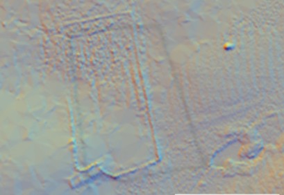
This deserted settlement, 400m east of Thieves Hill, comprises a pre-Improvement farmstead visible as a low standing structure. There is a two-compartment building with rounded corners.
Bibliography
| RCAHMS | 1998 | Forts, Farms and Furnaces: Archaeology in the Central Scotland Forest, (50) (Quoted below) |
The monument comprises a farmstead of pre-Improvement date, visible as a low, standing structure.
The monument is situated in newly planted woodland at about 160m O.D. The monument comprises a two-compartment building that measures c. 24.4m ENE-WSW by c. 6.2m transversely over faced-rubble walls spread to c. 1.4m in thickness and 0.4m in height. The corners of the building are rounded. The eastern compartment is the longer and slopes downhill, perhaps indicative of its use as a byre. The wall of a large drystone sheepfold has been built over the northern wall of the building. A swathe of rig occupies the fields to E and W.
The remains appear to represent a small farmstead of medieval or later date. The form may indicate a relatively early date. The site is depicted on Roy’s mid 18th century survey, but had disappeared by the time of the 1st edition Ordnance Survey map a hundred years later.
The area proposed for scheduling comprises the remains described and an area around them within which related material may be expected to be found. It is circular in shape, with a diameter of 50m, as marked in red on the accompanying map extract. The rig is excluded from the scheduling.
