(Slamannan Mill)
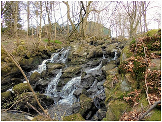
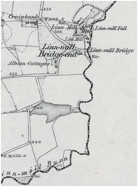
The name of this mill derives from a waterfall immediately to the east of the buildings described in 1860 as “a very beautiful waterfall, upwards of 60 feet” (Ordnance Survey Name Book), though it has since lost some of its former glory. The stream itself is also named after this linn – the Linnmill Burn which continues north to the River Avon and forms the boundary between Stirlingshire and Linlithgowshire. Linn Mill Bridge on the road from Avonbridge to Strath is likewise so named and from this we get Linnmill Bridge-End for the nearby cottages. Linnmill Brae is the name of the road from there to Avonbridge. Yet the stream has an older name – the Polness Burn, meaning “burn of the waterfall.” (Reid 2009 170).
James Pennay was the miller in “Lynnemiln” in 1570 and c1585 it is shown on Timothy Pont’s map. The Pender family had a long association with the mill with a James Pender noted there in 1624 when he had a grant of :
“all and haill those parts and portions of the lands of Slamannan Muir commonly known as Linmilne with the hill commonly known as the Schillinghill with the mill-lands, multures”
(Reid 2005, 52).
At that time it belonged to Lord James Sandilands of Slamannan. It was the feudal mill for one of the two parts of Slamannan.
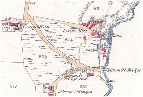
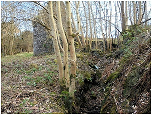
The original mill lay immediately to the west of the linn at the foot of a large ridge of rock over which the burn cascades. Cutting channels in this whinstone is no easy task and they follow natural fissures which have been artificially widened. We can therefore be pretty sure that the mill dam and lades were little changed over the years. The mill pond lay on the top of the ridge to the west of the stream.
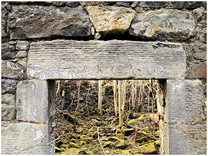
After at least four generations of millers called James Pender the mill fell to the daughters of the last of these around 1680. It is doubtful if their husbands operated the mill themselves and so we do not know the names of the following millers until it came into the hands of another dynasty of men with the same name – in this case Robert Inglis. The inscription on the lintel of a new lint mill constructed between the pond and the stream is inscribed “RI KC 1820”, though an earlier inscription appears in the background. RI is presumably for Robert Inglis. An additional sluice had to be inserted to take the water to the new wheel and thence back into the main lade for use of the northern mill which was also converted to process flax.
In 1860 the Ordnance Survey recorded the site of Linn Mill as:
“A group of buildings consisting of dwelling houses, two lint mills and offices. The dwelling houses are two stories, together with the offices. One of the mills is three stories, the other one. The mills and offices are slated and in good repair. The dwelling house thatched and in bad repair. Property and residence of Robert Inglis Esq. The machinery of the mills is propelled by water.”
In the 1870s Robert Inglis of the Linn Mill provided summary reports for the Yorkshire Post on the nature of the crops grown in East Stirlingshire. Millers were in a particularly good position to do this as they dealt with much of the produce. Here, for example, is his report for 1874:
“This is not a wheat county. Barley and oats are grown over the usual extent. Swedes are a good average crop, and white turnips over an average. Potatoes are an average crop. Wheat is an average crop of about ten bolls per acre. Barley is an average of from eight to ten bolls per acre. Under an average quantity of stock has been grazed. Hay is an average crop. Robert Inglis, Linn Mill, Falkirk, Stirling.”
(Yorkshire Post and Leeds Intelligencer 18 August 1874).
Robert Inglis died in July 1879 and his son, also Robert, gave his occupation as miller and farmer for the 1881 census.
| FORENAMES | SURNAME | RELATION | STATUS | AGE | OCCUPATION | WHERE BORN |
|---|---|---|---|---|---|---|
| Robert | INGLIS | Head | Married | 61 | Miller & farmer of 56 acres | Slamannan |
| Margaret LIVINGSTON | INGLIS | Wife | Married | 36 | Miller & farmer’s wife | Glasgow |
| John | INGLIS | Son | 24 | Farmer’s son | Slamannan | |
| Marion | INGLIS | Daughter | 22 | Farmer’s daughter | Slamannan | |
| Jane | INGLIS | Daughter | 11 | Scholar | Slamannan | |
| Robert | INGLIS | Son | 9 | Scholar | Slamannan | |
| Margaret | INGLIS | Daughter | 7 | Scholar | Slamannan | |
| Elizabeth | INGLIS | Daughter | 5 | Scholar | Slamannan | |
| James | INGLES | Son | 3 | Slamannan | ||
| John | INGLES | Nephew | 25 | Farmer’s nephew | Muiravonside | |
| Janet | INGLES | Niece | 21 | Farmer’s niece | Muiravonside | |
| Robert | INGLES | Nephew | 19 | Grocer | Muiravonside |
By the time that the 1897 map was surveyed the upper lint mill seems to have gone out of use and the lower mill is described as a corn mill. This situation had not changed by 1913.
“STIRLINGSHIRE. FARM, & C., WITH MEAL MILL, NEAR AVONBRIDGE, FOR SALE. WATER AND STEAM POWER. For Immediate Disposal, by Private Bargain. ALL and WHOLE, the LANDS of LINMILL, together with the LANDS of FALKHOLM, and other Lands adjoining, in the parish of Torphichen, with the DWELLING HOUSES, STEADING, MEAL MILL (Water and Steam Power), and WHOLE MACHINERY thereon. The Lands extend in all to between 40 and 50 Acres, and belonged to and were occupied by the Late Mr Robert Inglis of Linmill. All further particulars will be supplied by Mr John Inglis, Blairfordel, Blairadam; or by the Subscriber, with the latter of whom Offers must be lodged forthwith.”
(Falkirk Herald 25 October 1902).
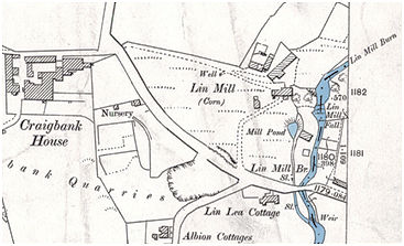
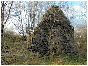
The 1955 map shows that the upper mill was in ruins but the lower one had been demolished.
| MILLERS | ||
|---|---|---|
| 1570 | James Pender | |
| James Pender | ||
| James Pender | ||
| James Pender | 1680 | |
| 1820 | Robert Inglis | |
| Robert Inglis | 1879 | |
| 1879 | Robert Inglis |
Sites and Monuments Record
| Linn Mill (Slamannan Mill) | SMR 635 | NS 9120 7227 |
