(Bowhouse Mill?)
In 1625 Patrick Macknellan was the miller at the “mill of Mumrallis”. This had been part of the lands of Abbotskerse, but in 1632 it was acquired by the Earl of Linlithgow. An entry in the baron court book reads:
“Ordanes the haill tennentis of Over and Nether Mumbrellis to grind thair haill cornes grindable at the Mumbrellmylne And to pay mwlter and kneaveshyp thairfoir according to use and wont And quhatsoever cornes theysall sell or grind by the said mylne And to pey fyve punds penaltie for ilke tyme they sall pas by the said mylne to any other mylne.”
John Beyge (miller at Langton Mill in 1639) was in post at Mumrills in 1643. The last known notice is from 1683 when Alexander Mitchell, John Gilmor, James Struthers and Thomas Dougall were prosecuted “for abstracting corn from Mumbrills miln”.
The site of the mill is not known. It is not shown on Pont’s map of the 1580s but the name shows that it must have been on the Westquarter Burn. Further upstream was Langton Mill in the Barony of West Kerse, and downstream was Bowhouse Mill. It is possible that the name was changed to Bowhouse to better reflect its immediate location rather than the main holding. In 1656 the wife of Thomas Johnston confessed to the baron court that she had bypassed Lady’s Mill and gone instead to Bowhouse Mill which was also in the lordship of Callendar
Laurence Dundas of West Kerse bought the mill in 1754 when James Potter was “Multurer at Bowhouse Miln.” The property at this time was described as
“the miln commonly called the Bowmiln with the pertinents of the same as long ago was built upon the lands of Mumrels which sometime belonged to the deceased James Earl of Linlithgow“.
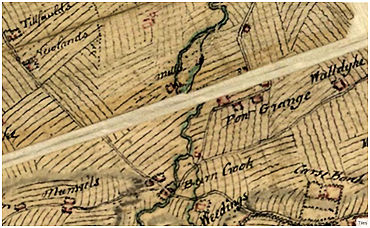
Roy’s survey of c1755 depicts a mill with its lade on the east side of the Grange Burn. This straight lade is the modern course of the Grange Burn. The map drawn by Robert Whitworth for the Borrowstounness Canal in 1789 shows “Bow’s Mill” on the lade with the Mill House opposite Bowhouse Plank. It does not appear on Grassom’s map of 1817 or the first edition Ordnance Survey map and presumable went out of use around 1800.
| MILLERS | ||
|---|---|---|
| 1625 | Patrick Macknellan | |
| 1643 | John Beyge | |
| 1651 | Henry Beyge |
Sites and Monuments Record
| Mumrills Mill | 1196 | NS 92 79 |
| 1077 | NS 9265 8065 |
