Airth Mill served the Abbey of Holyrood whose lands formed the heart of the later Barony of Airth. The senior barony on the parish was that of Elphinston (later Dunmore) and it is likely that it had its own mill from an early date. The earliest overt reference to a mill occurs in 1601 when Robert, Lord Elphinston, and Alexander, Master of Elphinston, his son and heir apparent, were confirmed in the lands and barony “with the castle thereof, manor, mill and mill-lands” (Reid 2004, 65).
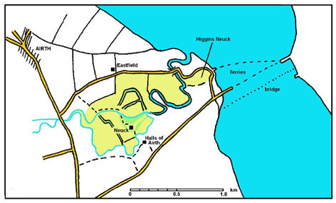
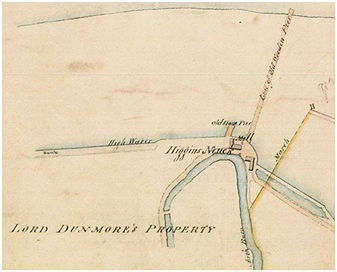
There are few suitable locations for a water mill in the main area of Elphinston but the Halls of Airth, lying on the south side of Airth Pow, were part of the barony and so it is probable that the mill lay in that vicinity. The charter for Airth Mill in 1618 mentions two other mills further down the Pow – referred to as Patrick Higgin’s old mill and Patrick Higgin’s new mill. The family’s landholdings lay on the north side of the Pow within the Barony of Airth and two mills are associated with these – one immediately to the north of Neuk House (the Nether Mill of Airth), and the other further to the east. It has been natural to assume that the latter was what became known as New Mill or Newmills at Higgin’s Neuk at the ferry crossing to Kincardine. However, it actually stood on the east side of the Pow and therefore outwith the land belonging to Patrick Higgins but within the Barony of Elphinston.
In 1654 Sir Robert Elphinston of Quarrall had a charter from Alexander Lord Elphinston of part of the lands of Airth “with the milne called the New Milne“. Just how new the mill was in 1654 is open to dispute. John Reid suggested that the mill may have taken advantage of infrastructure put in place at the beginning of the 16th century for the royal dockyard and this seems like a reasonable supposition. In this case the mill may well have been constructed in the almost a century before Elphinston of Quarrall acquired the land. Also belonging to this early period may have been the substantial sea wall or wharf adjacent to the mill. The scale of this feature is truly amazing and smacks of a national rather than a local project. Its presence would have allowed grain to be delivered to the mill using the Forth and for the flour to be exported up to Leith and beyond.
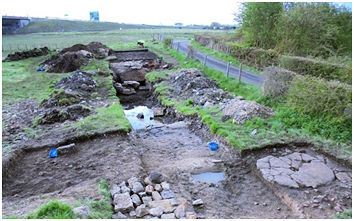
By that time the location had become an important crossing point of the Forth and a stone pier immediately to the north-west of the mill provided a convenient landing point on the southern shore. The approach road to the pier lay beside the west gable of the mill. This substantial stone pier was excavated as part of SCAPE’s Inner Forth Landscape project in 2016 and 2017 (Graham, Reid, Bailey & Tipping 2018).
The mill used the water from the Pow Burn, diverting it into the Forth at the tip of a meander which approached within 50m of the old shoreline. This was 1.1km from its mouth but here the land is relatively flat and the mill was probably only operational at low tide. A weir must have been placed across the Pow for this purpose, still allowing surplus water to continue its normal journey. The channel or cut across the 50m strip was partially examined in the 2016 archaeological excavation and was found to be 8.5m wide and initially had gently sloping sides. This would be at odds with its construction as part of the mill which should have been much narrower with steep sides and may hint that it was originally cut to scour the silt away from the east side of the stone pier. A sluice under the modern road would have been sufficient for that purpose. The adoption of the channel for the mill took the form of stone walls reducing the width to 4.5m at the point of examination. The channel and hence the water wheel was located at the east gable of the mill and there was evidence for superior quality masonry in the lower courses of this wall.
Adam Baad was the miller in 1719. In 1738 Thomas Dundas gained the superiority of the estate of Newmills which was described as
“the five oxengait of land of the haughs or Halls of Airth commonly called Newmilns or Docks in the lordship and barony of Elphinston.”
The estate of Newmills took in the fields to the west of the mill bounded by a crook of the Pow. It is not known if the terminal “s” indicated that there was more than one mill here at the time or was merely a possessive meaning the Lands belonging to the New Mill.
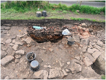
A large drying kiln was constructed to the east of the channel. It was 5.6m in external diameter at ground level with foundations of c1.1m dug into the carse clay. The lower part of the interior bowl was excavated. The interior faces sloped up from a central point to 2.0m diameter at ground level. As the walls were 1.75m thick as this level it suggests that the face continued to slope for some distance. The original structure was relatively simple and crude. That it was used for a considerable amount of time was demonstrated by the deep accumulations of ash outside the flue. The flue had been much modified over the period of use which would have been for many decades.
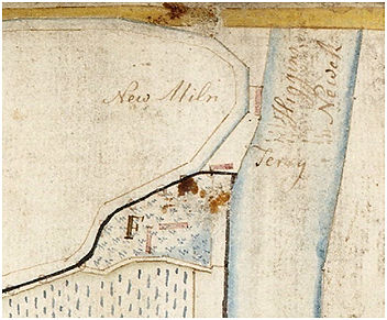
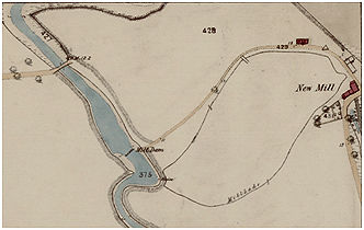
It is unlikely that there was sufficient water for the working of two mills. On an estate plan of 1784 it is marked as “New Miln” (RHP 80865). By the time that this map was drawn the stone pier had gone out of use and a wooden replacement had been constructed to the east of the mill to extend across the newly accumulated mud flats. The main problem seems to have been the rapid siltation of the area to the north of the sea wall. Over the 250 years or so following its construction extensive salt greens had accumulated. The drying kiln was demolished and a road placed over it to the new pier.
Newmills was advertised for sale in 1757 and part of the description suggests that the mill may have been out of use. It is necessary to provide the reference to the mill in context to understand it properly:
For sale “the house of Newmilns, consisting of seven fire rooms and cellars, with convenient offices, a large pigeon house, and 14 acres of inclosed Kerse ground, with a garden of two acres, all lying contiguous to the house, about a short mile below the town of Airth … Just by the house, and which is part of the property, there is a safe and convenient harbour, sufficient to receive ships of 200 tons burden, and likewise a place where a corn mill may be built to advantage, and there is already built on the side of the harbour, a girnel house, which will contain 2,500 bolls of grain…”
(Edinburgh Evening Courant 10 February 1757,4c).
This shows the small extent of Newmills – only 14 acres. The reference to the harbour is tantalising as it could refer either to the mouth of the Pow which was used at this time, or to the wharf and pier just mentioned. Given the presence of a sizeable girnal house or granary the latter is more probable (no structures are shown on Roy’s map or the 1st edition Ordnance Survey map at the former). To understand the subsequent history of the water mill it is essential to chart the management of the water courses.
Silting at the new pier was causing concern and so in 1786 Lord Dunmore explored the possibility of diverting the Pow Burn into the Forth at this point to increase the scouring action. The bridge over the Pow at Newmilns required reconstruction and so he proposed to construct a damhead across the stream to carry the new road. This would have rendered the New Mill Pool (ie the Pow north of the old bridge) useless as a harbour and so he offered to excambion land with Graham of Airth so that he could still have a shipping place for coal, lime and such forth (NLS ms10877, 6). The requirements for access and future navigation made this unworkable (NLS ms10877, 11) and in 1788 a new bridge was built by Charles Stuart on the site of the old one. Nevertheless, the damhead was constructed and the meander of Higgins Neuk was cut across. This effectively turned the entire meander into a mill pond for the New Mill, increasing its ability to remove the mud from the ferry pier.
Even this was not enough and the new pier or “ferry-boat steps” was beginning to prove impracticable for the ferry and so in 1789 Lord Dunmore decided to construct a new “landing place to the south-east” (Edinburgh Evening Courant 24 December 1789, 1b) and the remains of this even longer wooden pier with its approach embankment are still prominent.
Further modifications were required when steam boats started to use the newest pier. It was decided to create a reservoir along the sea wall to the south of the mill at Newmills “for which they needed water from the mill there to clear the mud at regular intervals” (NLS ms10877, 206). Permission of the Grahams of Airth and Lord Dunmore was required to use water from the Pow Burn.
It was probably the siltation which caused the eventual demise of the mill. It was still labelled as a mill on a map of 1828 (RHP 4298 – Plan of the Forth opposite Tulliallan), but by the time of the 1861 Ordnance Survey map it is shown as a roofless structure. A replacement was built to its south-east and it must be assumed that its lade lay along its south gable. The L-shaped building is present but uncaptioned on the 1828 map and in 1861 appears as “New Mill.” That was just a place name and not a functional designation as made clear in the accompanying Name Book which describes it as:
“The building to which this name applies was formerly a corn mill, but a part of which is now in ruins and the remaining part is occupied as a cothouse. Property of the Earl of Dunmore, Dunmore Park, Airth.”
It was probably the home of the change keeper who operated the ferry.
Sites and Monuments Record
| New Mills | SMR 891 | NS 919 872 |
