Pocknave Mill was situated at the head of the Muir Dyke Burn at the point where it falls into the Forth Estuary. The burn formed the boundary between the parishes of Bothkennar and Airth and the mill lay on the north side within the latter parish. Evidently the pow and the lead were one and the same as it was noted in 1790 that the estates of Pocknave and Orchardhead were:
“contiguous being only separated by the mill-lead of Pocknave, which is the march of the two parishes”
(Caledonian Mercury 12 April 1790, 3).
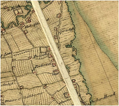
It was located between the arable carse land to the west and the salt greens bordering the estuary on the east, which suggests that it may have been a tidal mill. Roy’s map of 1755 shows a large amorphous pond aligned with the coast just to the north of the burn at this point. Dressed stonework may still be seen in the burn at NS 9211 8504 and this may have housed the water wheel, though the coastline and local topography was much altered in the 1780s by the construction of large reclamation dykes which necessitated the insertion of clap drains immediately to the east. The earliest record of the mill is in 1618 when Robert Bruce was designated as “miller (molendinario) at Poiknaiff” (Reid 2004, 67).
For a while Pocknave belonged to a cadet family of the Bruces of Stenhouse and the presence of a large rectangular doocot shows that it was a seat of the minor nobility. Pocknave was sold to Andrew Simpson of Grange of Bothkennar in 1625, including “all and haill the lands of Powknaiff with the mill and mill-lands, houses…” The mill continued in operation until the 18th century. Its date of closure is confused by the use of the place name “Pocknave Mill” to denote the adjacent farm buildings. The Ordnance Surveyors noted in 1860 that it referred to :
“A farmsteading, one storey, thatched and in good repair. Property of J W Ogilvie Esq, 22 Cumberland Place, Glasgow. A corn mill stood near it but it has been removed, from the above circumstance it derives its name.”
It is probable that the land reclamation may have contributed to its demise.
| MILLERS | |
|---|---|
| 1618 | Robert Bruce |
| 1625 | Robert Allan |
| 1653 | Archibald Duncan |
| John Miller | |
| 1702 | John Miller |
Sites and Monuments Record
| Pocknave | SMR 892 | NS 9211 8504 |
