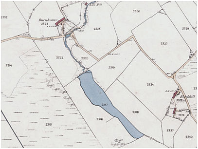
This lint mill was established between 1755 and 1817. It appears on Roy’s map and Grassom’s map, 770m south of Allandale. At the time the government was encouraging the industry. The large pond to the south may have been used for steeping the fibres. In 1836 David Spiers is recorded as the proprietor, and it was still worked by John Spiers in the 1850s. In 1858 the Ordnance Survey described Burnhouse as
“A farmsteading 1 storey high, slated and in good condition. There is a lint mill belonging to the farm about 5 chains to the north-east. It is worked by water wheel about 6 horse power. The building is slated and in good condition. Property of Mr John Spiers & residence.”
The mill consisted of a small rectangular building to the north-east of the farm of Burnhouse beside the Skipperton Burn. As a result of terracing the south wall is c3.5 m tall from the outside, but only c2.5 m inside the building. Beam slots in this wall show that it was two storied. The doorway, with plain margins, lies central to the north-east side. The south-west wall has completely collapsed, no doubt due to the fact that it lay alongside the lade and carried the water wheel. The north-west wall is buried under rubbish dumped down the valley side from the farm buildings. The mill was fed from a large pond created on the line of the burn by an earth dam. Though not deep, the pond lay at some distance above the mill and would have provided a clear head of water. The damhead was lined with sandstone, part of which may still be seen. It has been extensively restored with a new sluice installed to a concrete spillway in 1995.
Sites and Monuments Record
| Burnhouse Mill | SMR 513 | NS 8064 7804 |
