The earliest known reference to this mill is on an estate plan of 1764 (RHP 1483). It does not appear on the plan of the mills on and adjacent to the River Carron prepared in 1760 for Carron Company (RHP 1497), nor on Roy’s Great Map. The latter map shows the original course of the East Burn which was diverted to run along the west side of the road to Dalderse Mill Farm (and which road joined with David’s Loan) in order to follow the contour. In 1783 William Glen purchased portions of the lands of Dalderse including the mill.
Dalderse Mill lay on flat carse lands and was powered by the East Burn of Falkirk which was joined by the Bainsford Burn a little south of the mill. The construction of the Forth & Clyde Canal reduced the effectiveness of the mill, the burn being piped under the canal. Reference to this is made in 1810:
“the mill called Mill of Dalderse with the Pipe of Water from the Great Canal betwixt the Firths of Forth & Clyde for supplying the said mill with water.”
It was probably during the construction of the Canal that much of the water from the East Burn was diverted eastwards to the Temporary Cut. The Bainsford Burn continued to run to the mill.
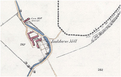
The mill was still in use in 1817 and is shown on Grassom’s map. The building is noted as “Corn Mill (disused)” on the 1859/62 Ordnance Survey map, and the name was transferred to an adjacent farm. The accompanying place name data states:
“A large farmsteading with a corn mill attached. All one storey in height, thatched and in good repair. Property of the Trustees of Miss Stainton.”
This suggests that the mill had only gone out of use around the time that the map was surveyed, which would not be unusual as it was then that foreign imports impacted most heavily upon corn mills in Scotland. By 1877 the dam was called a duck pond (Falkirk Herald 25 October 1877).
Sites and Monuments Record
| Dalderse Mill | SMR 656 | NS 8996 8203 |
