Glen Mill was located on the north side of the Glen Burn just beyond its junction with the Westquarter Burn and as a consequence made no use of water from the latter. This was part of the Lands of Callendar.
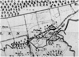
It is depicted on the plan of Callendar produced in 1781 for the sale of the estate. This is an interesting plan as it has been updated at various times. It shows a lade starting at a turn of the Glen Burn 150m to the west of the mill and feeding a small mill pond immediately adjacent to the mill. A second and presumably later lade leaves a more prominent turn in the stream 340m west of the mill and leads to a large mill dam on the same contour, above the previous dam. Both of these were in turn swept away by the imposition of the field enclosures and the associated roads. Accordingly, the large mill dam lies under the present road to Westquarter. These enclosures were formed in the late 1780s after William Forbes purchased the estate.
In 1783 mention is made of “Hallglen Mill lands”, but it then disappears from the record (Reid 2005, 39). The augmentation of the water courses suggests that the mill was created in the early 18th century. It was probably a lint mill.
Sites and Monuments Record
| Glen Mill | SMR 834 | NS 9026 7838 |
