The exact location of Woodside Mill is uncertain. The modern name for Woodside is Glenbervie. The mill is mentioned in a charter of 1711 as follows;
“and that piece of ground belonging to the said James Crawford through which the water runs to the miln of Woodside”
(Reid 2004, 84).
The existence of the mill is confirmed by another charter of 1803 referring to
“8 acres of the lands of Bogend on the west side of the Mill lead to Woodside Mill.”
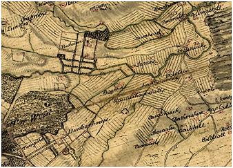
This suggests that the lade ran on a more or less north/south alignment and so would apply to a tributary of the Pow Burn (which runs west/east). It corresponds with “Lantounmill” shown on Roy’s Great map of the eighteenth century which is close to the farm of Lanton depicted on later Ordnance Survey maps.
The mill is probably that referred to in a charter of 1811 which includes
“the lands and tenandry of Larbertshiells comprehending the lands of Woodside and Staneriggmiln and miln lands thereof, being part of the feu duties of the Lordship of Stirling”
(Reid 2004, 84).
Rather confusingly, we thus have three names for the same mill.
The water supply to the mill was not copious and it is therefore not surprising to see no trace of it on the 1859 Ordnance Survey maps.
Sites and Monuments Record
| Woodside Mill | SMR 1228 | NS 862 857 |
