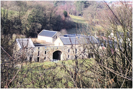
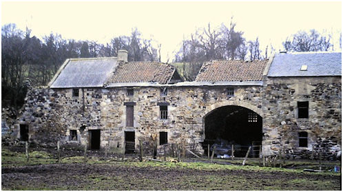
Situated on the western bank of the River Avon with a sweeping view of the Avon Aqueduct is a small cluster of farm buildings known as Manuel Mill (NS 9707 7618). These comprise an extensive mill building, early eighteenth century farmhouse, dairy cattle and machinery sheds. Today the size of the mill buildings is the most noticeable feature of the area and can only be explained by their proximity to the Edinburgh and Glasgow Union Canal, one of whose main goals was to transport flour from the mills on the Almond and Avon rivers to markets in Edinburgh. The mill buildings to the south of the farmhouse are a very impressive reminder of the importance of water power in the agriculturally based economy of the early 19th century.
The existing range of mill buildings is 46.1m long and is aligned south-west to north-east. The oldest part of the range (Phase I) took up 10.1m of this and lies immediately to the north of the large archway which dominates the frontage. Here the foundation layers of large whin stones protrude from the dressed masonry above. The walls are of random rubble and the voids have dressed sandstone margins. The lintels and sills in this part of the building are narrower than those of the later extensions. The two-bay building was three-storeys in height though it is probable that the upper floor windows were dormers. On the ground floor is a wider than usual doorway and a small window. Vertically above them, on the first floor, are a narrower doorway and a larger window. This doorway was evidently for loading and dowel-holes in its sill and the lintel below that would have been for a loading platform. To its right is a small window which appears to have been contemporary. It latterly served a small office separated from the rest of the level by a wooden partition wall. The office contained a small fireplace set in the original gable. The chimney stack for this has been replaced in brick. The lintels of the two second floor windows have been removed and a levelling course at this point suggests that the wallhead was raised in a subsequent renovation and the voids blocked with coursed masonry. It is probable that originally these small windows protruded into the roof and had dormer pediments. The abundance of broken pantiles on the site shows that at one time this was the main roofing material.
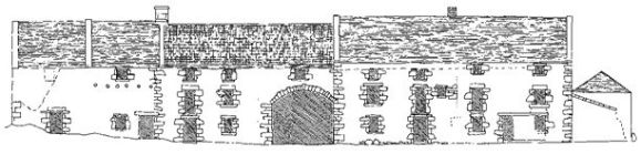
The mill pond lay to the back of the building at a higher level and consequently the back elevation only displays one and a half storeys. On the ground level (ie the first floor of the building) is a doorway with a timber lintel providing access directly from the mill to the sluice. The north gable contained two windows on the first floor.
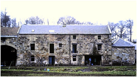
The water wheel was located on the south gable though the arrangements are obscured by later alterations and a rise in the ground level. The lower level of the gable towards the front of the building is of finely dressed ashlar blocks typical of mill buildings from the 18th century onwards designed to shed the splash of water from the wheel.
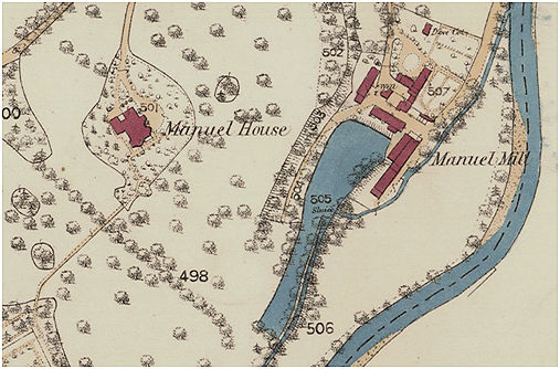
There is no datestone and the date of Phase I is not indicated in the written records. The mill itself dates back to the 15th century but on stylistic grounds the stone building of Phase I should belong to the mid-18th century and is probably one of those depicted on Roy’s Great Map of 1755.
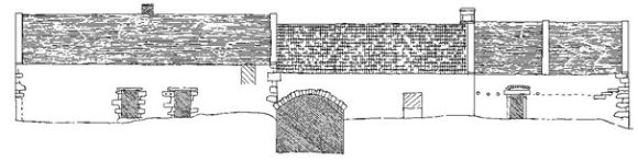
In the second phase the mill was extended to the south by a block which mirrored the original, doubling the size of the building. A gap was left between the two phases for the water wheels and this was spanned by a segmental arch at first storey level providing a second-floor room above. The window to this room was set slightly to the left of the centre of the arch. The upper floor windows of this block now have wooden lintels, but the heavy stone lintels of the lower floor windows hints that this is unlikely to have been the original arrangement and it is probable that they too had dormer pediments. In 1986 the remains of the pantile roof of this block were still in place with the traditional five rows of slates at the base over the wallhead. The plain skew on the south gable is a late feature resulting from further extensions. The gable was topped by a stone chimney stack with a chamfered capstone and served a fireplace on the ground floor – the flue passing between two gable windows on the first floor. The fire surround has been replaced by later alterations but it is unlikely to have been for a drying kiln which we might expect to find in a separate building due to the inherent risk of it having to be left unattended for long periods. The base of the chimney stack houses a thatch stone but this was probably for housing the pantiles rather than thatch. A second water wheel was placed on the north gable of the new extension within the arched opening. This would doubtless have necessitated enlarging the capacity of the mill pond. It is perhaps relevant to note that from at least 1833 the place is called Manuel Mills in plural. It is tempting to attribute the extension as a response to the completion of the Union Canal in 1822.
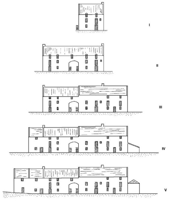
Whatever the case, the mill buildings were soon extended to the north, increasing the internal area by half as much again. The new block was similar to the previous two with loading doors on the first floor. This time the small second floor windows had ordinary stone lintels rather than dormer pediments. It must have been at this time that the original block was slightly raised and re-roofed and covered with slate. The upper windows in this section were also built up. Whilst the building thus lost its overall symmetry, it still possessed a unity of design with the voids arranged in vertical lines or bays. The extra provision of loading doorways and the remoteness from the water wheel suggest that the Phase III block may have been intended as a granary, storing grain and flour belonging to the mill’s clients.
The subsequent additions appear to have been connected with the keeping of livestock rather than the process of milling, though this is likely to have been their secondary use. On the north a cart shed was leant against the gable, leaving the windows on the first floor still open. It could have housed the four “close-bodied carts, with wheels and axles and corn frames; 2 mill-carts with wheels and axles” on sale at the mill in 1856 (Falkirk Herald 30 October 1856). Mill Carts were also listed in the displenishing sale of 1892 when Peter Roberts retired from Manuel Mill (Falkirk Herald 22 October 1892).
The nature of the two southern extensions is difficult to determine due to later alterations and their poor condition. It was initially supposed that the presence of a central skew meant that they were constructed consecutively from north to south. It is, however, possible that they were actually built at the same time but comprised of two separate units. That adjacent to the Phase II gable has two windows on the front façade with chamfered margins and its appearance suggests that it may have been accommodation for a miller. The end compartment may likewise have provided accommodation for mill and farm servants on a seasonal basis – acting as a bothy. A doorway on the first floor in the gable suggests that it was divided into two flats. At a later date ceramic pipes were inserted to provide ventilation so that livestock could be kept in them.
The rear door in the first of these compartments is also a late insertion. It has monolithic rybats and a flat relieving arch of red brick.
The mill had reached this stage of development sometime before 1860 when the first edition Ordnance Survey map was produced. The accompanying description provides the following detail:
“A large building of three stories, with a two storey dwellinghouse and offices attached, all slated and in good repair. Property of the Carron Company. Machinery propelled by water – two water wheels each nine horse power – with a subsidiary steam engine of sixteen horse power. Carron Company proprietors, offices Carron Works.”
In August 1899 a fire broke out destroying the working mill. Fortunately, the Linlithgow Fire Brigade was able to save the grain and meal stores, in which a considerable quantity of material was located. The machinery was totally destroyed, including two valuable crushing stones which had only recently been put into the mill. The roof was replaced and the interior rebuilt.
