The windmill at Bridgeness is set on a rocky mound that juts out from the higher ground to the south shore of the Forth forming a slight promontory and which hence became known as “Windmill Crag.” The lintel of the ground floor doorway on the east side is inscribed “17DS HP50” and 1750 would be appropriate for a vertical-sided windmill of this description. The initials were those of David Stevenson, shipmaster, and his wife Helen Paterson, and they acquired the site from the Grange estate. It was in 1750 that William Belchier, a banker residing at Downing Street, London, bought Grange and began to develop the coalfield. It is unlikely that he would have invested in a mill at the same time as the mining operations and so we can assume that Stevenson had enough capital from his maritime interests to have done so.
There was already an old windmill on the site before 1750 as in August 1749 Stevensen is said to have bought a mill at Grange. It is this earlier windmill which is mentioned in the following advertisement:
“By adjournment, that upon Thursday the 13th of November instant, betwixt the hours of 2 and 4 in the afternoon, there is to be exposed to publick roup and sale before the Right Hon. The Lords of Session, four acres and a half of the Lands of BRIDGENOSE, several houses and a Wind-mill, and a feu duty of one merk Scots yearly, amounting on all to 300 Merks of rent, holding feu of a subject, lying in the Parish of Cammbdon near Borrostounness. Other particulars are to be seen in the hands of George Livingstone one of the Depute-Clerks of Session, and of Alexander Young at his writing chamber south side of the street opposite the Cross-well.
NB. The price of the Wind-mill and one year’s purchase of the Lands and Houses are now reduced out of the price at which they were at first set up.” (Caledonian Mercury 10 November 1740, 4).
It has been suggested that the windmill was originally constructed to pump water from the mines but its location seems at odds with that function. It would have meant cutting a shaft through the rock at its highest point. The windmill would have been used for milling corn, replacing an earlier water mill located nearby. It is annotated as a “windmill” on a plan dated 1772, at which time a steam engine was being used to pump the mines. In 1775 the low lying coastal land to the east of the windmill was known as “Windmill Links.”
Stevenson was a shipmaster and evidently did not intend to run the mill himself. Once the rebuild and refitting of the windmill was completed he put it up for rent:
“To be LETT for seven Years by publick Roup, to the highest Bidder, at the House of Edmund Aleyn Vintner in Bridgeneise, on Friday the 3d Day of April, at noon,
The WIND-MILL at BRIDGENEISE, near Borrowstounness, lately rebuilt, and the Machinery formed after a Plan of one of the best Mills of that Kind near London for manufacturing Wheat, being furnished with a Pair of the best French Burr Stones, two exceedingly good Sheeling Stones, a barley Stone, Bolt Mill Sieves and Fanners, al drove by the Wind, and which performs with greater Expedition and full better Work than any Mill of its Kind in Scotland; also makes barley to great Satisfaction, and with almost incredible Expedition, hath very good Accommodations, such as Barns, Kilns, a Dwelling house and two Acres of arable Ground, with some Grass Ground lying at the same, and a commodious Place for landing Grain. She is pleasantly situate upon a rising Ground, within a Musket shot from the Sea Side, lyes within a quarter of a Mile of Borrowstounness, in the Heart of a populous Country, and convenient for the Glasgow Market, and may have Garrets for Grain from the Proprietor on very reasonable terms. For further particulars and the Articles of Roup, enquire at David Stevenson Shipmaster in Borrowstounness the Proprietor, or at the House of the above Edmund Aleyn.” (Caledonian Mercury 23 March 1752).
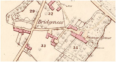
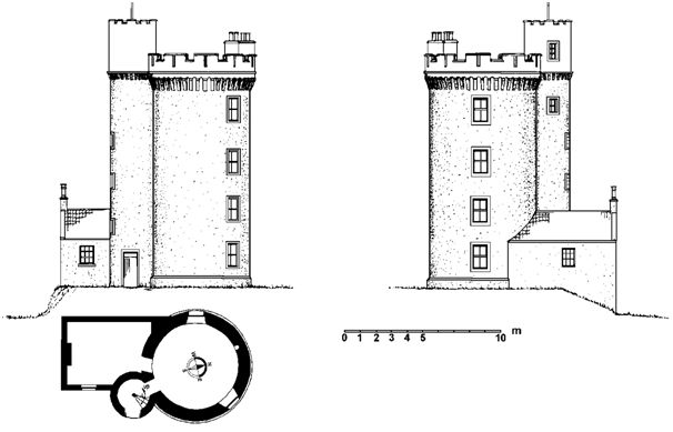
When built the tower was 7.1m in external diameter and only three storeys high. Roy’s Great Map of 1755 shows a sea wall around the foot of the promontory. The main road ran along the south side of the tower (continuing eastward along the present line of Bridgeness Lane to Grange House). A lean-to structure on this side of the tower was terraced into the hill side and had a stone vault at ground level. This allowed the grain to be brought into the shelter on a level where it was protected from the weather. The lean-to does not seem to have possessed a first floor and does not appear on the 1856 Ordnance Survey map.
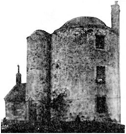
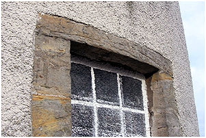
The use of the windmill seems to have been short-lived. In the early 19th century it was converted into a dwelling. A vertical series of large windows was inserted into the east face and a separate stair tower was added on the south side. Each floor was provided with a fireplace and a tall chimney was erected on the north side. The old wind cap was replaced by a domed roof.
The area to the north-east of the tower was used as a vitriol works, manufacturing sulphuric acid, and the businessman in charge lived in the converted residence.
By the time that the 1856 map was surveyed the tower was derelict. The course of the old road can still be made out but it no longer extended westward beyond the tower. It had been replaced by one along the coast to the north of the old sea wall. In 1892 it was noted that the old windmill at the Grange was one of the leading landmarks on the south side of the Firth of Forth. On a clear day it could be seen from Stirling and Queensferry (Linlithgow Gazette 21 May 1892). In 1889 it received a new coat of white-wash in celebration of the marriage of Henry M Cadell, the Laird of Grange – as had happened previously when his father too had been married.
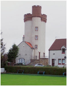
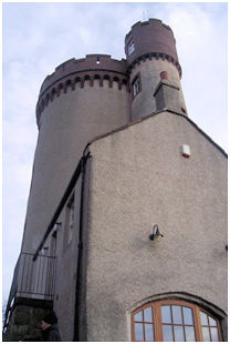
The tower had been empty for some time and Henry M Cadell even seems to have considered demolishing it, despite his interest in historical monuments. In 1892 Henry M Cadell decided to erect another storey on the building and to create a level observation platform on the top. The plans were drawn up by Hippolyte J Blanc to give an outward appearance of a Romantic battlemented tower of the kind seen on the shores of the Mediterranean. The inspiration for this work may have come from a similarly battlemented circular tower depicted on an oil painting at Grange House of an imaginary Italianate harbour scene. The extra storey was added, making the tower 13.5m tall, and capped with striking corbels and an overhanging parapet with embrasures. The brick parapets have self-coloured concrete copings and a stone string course. The corbels below the string course are also self-coloured material to match the brick. The lean-to shelter on the south was extended upwards by another storey with a pitched pantile roof, fitting snugly into the angle between the main tower and the small circular stair tower.
This secondary tower now rose above the height of the original to give access to the flat roof. The stair tower was capped by a steep conical roof surmounted by a weather vane. Confusion has arisen as the flat roof was called an observatory – meaning that it was a place to observe the scenery and not one for star-gazing! The well-known photograph of Bridgeness Harbour was taken from this vantage point in 1892.
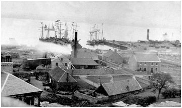
The extra height made it even more of a landmark and it acted as a good navigation beacon for ships entering Bridgeness Harbour which was then busy with coal ships. Later it was the guiding seamark for ships ending their lives in the breaking yard there. The ships would make their way to the opposite shore of the Forth near Preston Island and then line up with the tower. The master would then steam straight for it, contrary to all his instincts, so that when the ship hit the beach it would rise out of the water and rest on the gently shelving coast in order to make it easier to dismantle it. HM Cadell does not seem to have used the observatory much and was having difficulty in renting the accommodation. So when, in 1895, there was a severe shortage of housing for the working class he jumped at the opportunity to convert it into flats. Such was the housing crisis that the Dean of Guild gave permission for internal work to commence that June even before plans had been submitted. The opportunistic nature of the conversion is illustrated by the fact that Cadell was abroad that summer and was annoyed on his return to find that the workmen had accidentally covered the earlier doorway and its datestone with render. One of the labourers was subsequently fined for stealing 16 lbs of lead which the plumber had left in a press inside the building (West Lothian Courier 12 October 1895, 8). All of this work made it possible to fit four dwellings into the cramped space, though in 1902 the local newspaper wryly noted that
“It forms an attractive landmark, and no doubt has also proved a good investment, for it is inhabited by no less than six families, probably a population of between 20 and 30 souls.”
(Linlithgow Gazette 12 September 1902, 3).
In 1897 the tower was illuminated with padella lights for Queen Victoria’s Diamond Jubilee and this was repeated in 1902 for Edward VII’s coronation. On that latter occasion HM Cadell even considered mounting an old carronade on the top of Bridgeness Tower and firing it (Linlithgow Gazette 9 May 1902, 5).
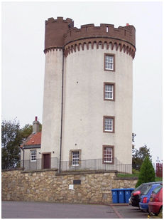
In September 1930 a great storm raged around the shores of the Forth and the stair turret of Bridgeness Tower was struck by lightning. A cloud of smoke followed the flash as it struck and slates were dislodged, rattling to the ground. The woodwork below the slates was scorched but thankfully did not catch fire. At the home of Mrs C Sneddon on the second top-storey lightning travelled up the waste water pipe – an eye-witness saw little blue sparks run down the side of the building – to the earthenware sink cracking it. An aluminium pot in the sink had three clean holes burnt in it, the largest about the size of a shilling. Mrs Sneddon was in the washing-house at the time but three very scared young children were in the kitchen (Linlithgow Gazette 5 September 1930, 5). The conical roof of the stair tower was removed and replaced by a flat one set behind battlements.
The tower served as housing up to about 1950 when it once more became empty. It again fell into disrepair and it was difficult to see how it could be economically utilised. In the 1970s the possibility of converting it into a heritage centre was looked at, but the narrow stair made it impractical as a public building. However, through the persistence of HM Cadell’s grandson, William A Cadell, who was an architect, it was renovated 1987-9 as a single dwelling, with other houses built around it in the form of a square earning it a Saltire Society Award Commendation in 1990. The heavy chimney stack was truncated.
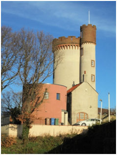
Despite now being a single dwelling it was decided to extend the living accommodation at the lower levels in 2014. The new extension echoes the drum shape of the original tower but is deliberately squatter and more modern in appearance. Being built off to one side it does not detract from the original but harmonises with it.
Sites & Monuments Record
| Bridgeness Tower | SMR 300 | NT 0131 8147 |
