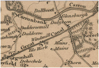
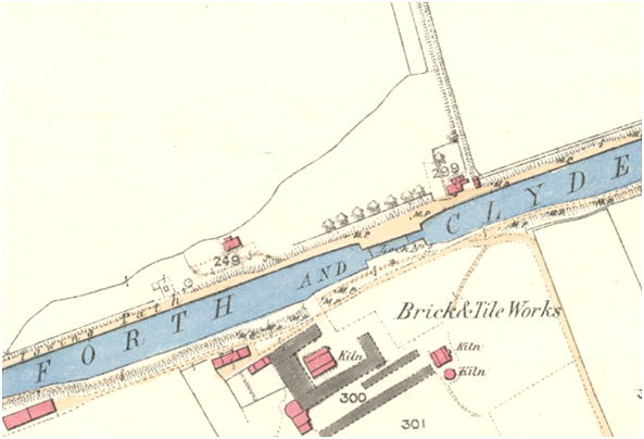
A “Windmill” is shown on Grassom’s map of 1817 but the location is not named. The location indicated is on the north side of the Forth and Clyde Canal opposite to the Earl of Zetland’s tile works. This appears to correspond with an unroofed circular structure shown on the 1862 Ordnance Survey map between the canal and the Lady’s Mill Burn, a little to the west of Lock 3, which would place it on the Zetland estate – the stream being the northern boundary. This is a curious location and the feature on the 1862 map lies immediately to the north of the towpath and so would have been on the embankment. To its west a series of small enclosures look like they may have been water tanks. It is therefore very tempting to propose that it was used to pump water up from the burn to the canal. This would not have been for drainage purposes as the stream took a turn to the north to flow into the River Carron. Nor would it have been constructed by the Canal Company to augment its water supply as it was clearly out if use by 1860 and that company could have spent its investment to greater effect elsewhere.
The location may, however, be significant. It is just up-lock from the junction of the Forth and Clyde Canal with the Temporary or Carron Cut. The Temporary Cut had been dug by the Canal Company in 1769 to transport stones for the construction of its locks. It was not decommissioned and in 1773 Carron Company started to use it as an inland navigation joining the river and the canal but was forced to cease this usage two years later. Then, in 1781, Sir Lawrence Dundas decided to make the cuts on the river which he had long promised at Grangemouth. This involved considerable disruption to traffic on the river and during the work it was decided to reopen the Temporary Cut. John Smeaton recommended strengthening and raising the height of the banks, equivalent to those of the main canal, and it re-opened in 1782 whilst the river was straightened. Once this had been achieved the Temporary Cut was closed for the final time.
It is therefore possible that the windmill was constructed in 1781 at the expense of Dundas, the Earl of Zetland, who was also a director of the Canal Company. In this position it would have replenished the lockful of water lost every time that a vessel was forced to use the Temporary cut. Its position also meant that it contributed to the drainage of the fields to the south. However, once the Temporary Cut ceased to be used the function of the windmill was much diminished and it is not therefore surprising to see that it quickly fell out of use.
Sites & Monuments Record
| Kerse Mains Windmill | SMR 1233 | NS 9025 815 |
