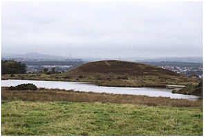
Elf Hill (SMR 967) is first mentioned as “a little height” in 1697 by an antiquarian following the Antonine Wall. As we are uncertain of the identity of the person he is usually referred to as “The Anonymous Traveller” (HMC 1899). It is named on all the editions of the Ordnance Survey and in 1860 was described by that body as “A rocky mound in a barren moor, upon the south side of Antoninus Wall”.
Illus: Roy’s Map of 1755 showing the site of Elf Hill with the Loch to its south.
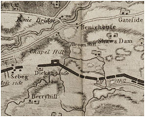
The name is a reflection of the mystical character of the location. The map accompanying Horsley’s publication shows two hills at this location. Today there is only one hill and we might be forgiven for concluding that one of the hills has magically disappeared. This is not the case. Horsley was using source material which he misunderstood. He must have had access to Robert Sibbald’s notes which included a diagrammatic representation of the Antonine Wall down the right margin of the page and a list of associated place names to its left. Whilst most of the names were of places along the line of the Wall or to its immediate south, some were located to the north – such as Camelon and the two Hills of Dunipace (see illus 33 in Keppie 2012). These hills had attracted much antiquarian speculation. Their steep profiles suggested to the early historians that they were artificial mounds, with one erected by the Romans and the other by the Caledonian tribes to mark a peace treaty signed on the spot. This was largely based upon the false derivation of the name “Dunipace” from the Latin “Duni Pacis” meaning the Hills of Peace! An idea was also floated that the hills were burial mounds for the dead of the two armies.
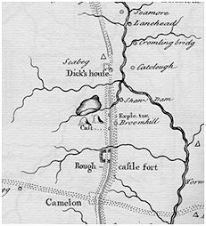
Today they are viewed as geological formations derived from the retreat of glaciers with one of the hills re-shaped in the 12th century for use as a motte to protect a nearby crossing of the River Carron. On Sibbald’s diagram they just happened to correspond to the location of Elf Hill and hence the error on Horsley’s map which also shows Camelon to the south of the Wall.
Stuart in 1852 regarded Elf Hill as a watch tower; Waldie (1883) as a burial mound; and George Dougall as a fort. Even as late as 1892 it was supposed that it was an artificial hill (Irvine Times 12 August 1892, 2). In the nineteenth century it too was covered with trees. They were removed at the end of the century and by 1918 there were only a few remaining trees on Elf Hill (Falkirk Herald 27 July 1918, 4). Many groups walked this stretch of the Antonine Wall in the late nineteenth century and were shown by local historians the point near Elf Hill where Graham was supposed to have broken through it. Oral tradition then lapsed and few local people held onto that knowledge.
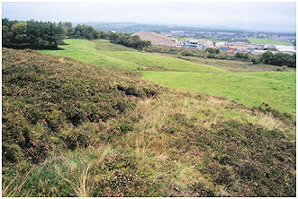
Denuded of trees the promontory of the Elf Hill provided a vantage point for observing the surrounding countryside. This became particularly important during the Second World War with the threat of another foreign invasion – this time by the Germans. Initially the hill was used as an observation point by the Bonnybridge Home Guard.
As tactics changed they dug a curving zig-zag slit trench just below the flat summit around the east side of the hill from which to defend Bonnybridge. It was complemented by several fox holes. Further defence was provided by a machine gun post on the flat roof of the office block of Smith and Wellstood’s foundry next to the bridge on the Forth and Clyde Canal. Inevitably tactics shifted, and the Bonnybridge Guardsmen were detailed to abandon their home village in the event of an invasion and defend the strategic point at Grangemouth Airfield (Bailey 2008). The end of the war in Europe brought forth jubilant celebrations. At Low Bonnybridge there were nine large bonfires. High Bonnybridge had seven bonfires, including a large one on the Elf Hill (Falkirk Herald 12 May 1945, 4).