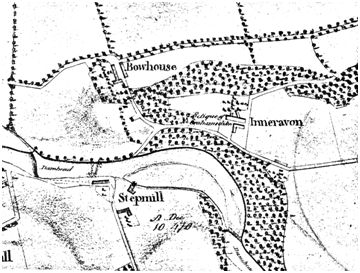
Stepmill was located on the south bank of the River Avon near Inveravon and was thus in the Barony of Abbotskerse. A weir across the river diverted water into the short lade and the water returned to the river just before the damhead of Jinkabout Mill. As with other baronial mills it is depicted on Pont’s map of 1580 (though the margin of this section of the map is damaged and the name unreadable).
In 1652 James Menteith of Polmonth Mill inherited the property of his grandfather which included “four oxingait of the lands of Clerkstoune with the corne mill within the barony of Abbotskers and regalitie of Brochtoune.” It is shown as “Stobmill” on a map of 1684. In 1709 James Menteith of Millhall raised a declarator of thirlage against the vassals of the lands astricted to the mills of Polmont. It was stated that he
“Has the mill of Clerkstoun, and took a tack of Duke of Hamilton’s mill of Crooked Wheel [Jinkabout], so that no differences could arise over the damhead.”
It is named Stepmill in 1784, at which time the mill employed a miller called Archibald Walker, who was designated as a dryster (a person in charge of the drying of grain in a kiln). He was the brother of William Walker employed at Neuk Mill in Muiravonside (NLS Acc 5381). At that time the occupants of Candie and Powdrake (in what is now the refinery) were thirled to Stepmill. In 1788 it was reported that the malt kiln there, belonging to James Walker, was burnt on 30 January and “which, with the contents, was totally consumed.” (Caledonian Mercury 2 February 1788, 3).
“MILLS TO BE LET. To be Let by public roup, on Tuesday the 15th day of October curt. within the house of James Smith, innkeeper at Polmont Church, between the hours of twelve and two o’clock, THE MILLS of POLMONT, called the Mill of Stepmill and Millhall, and the Mill of Bowhouse, as presently possessed by James Walker, with the Mill Lands at Stepmill and Bowhouse, consisting of about 25 acres, or thereby.
The entry to the mills and lands to be at Martinmas 1793 – and the mills to be repaired by James Walker, and put in as good condition as at his entry.
For particulars apply to Andrew Longman, the factor at Kerse.”
(Caledonian Mercury 5 October 1793, 1).
In 1820 it came into the possession of William Logan of Clarkston as part of an excambion. By that time the mill had probably ceased to operate and all later references tend to refer to the lands associated with the holding. By 1855 when the Ordnance Surveyors were around the buildings had been demolished and the name does not appear on the first edition map.
