
SMR 2362 / NS 8925 6977
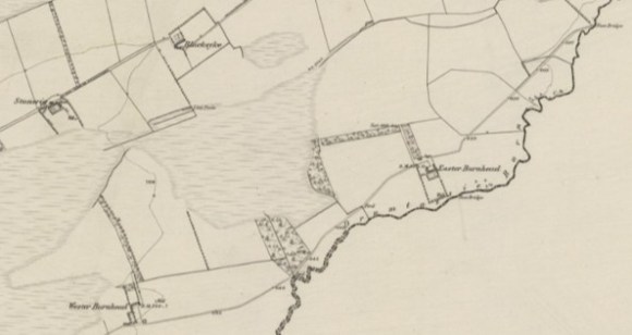
The farm of Easter Burnhead lies on the south-facing slopes to the north of Druntassie Burn which forms the southern boundary of the Falkirk district (NS 8928 6976). It has a swathe of pasture connected with it. To the north-west is Burnhead Moss, and the better-known Blawhorn Moss lies to the south-west.
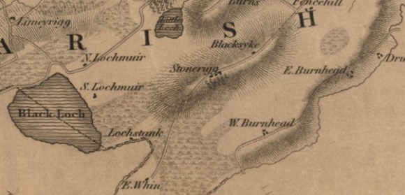
“Burnhead” appears on Pont’s map of c1560, and upon Roy’s map of 1755. It is also mentioned in 1624 when John Tennend junior in “Burnheid” appeared at a register of sasine. It was then noted that Burnhead was part and portion of the lands of Slamannan Muir (Reid notes).
It was only in 1732 that the outfield lands of Burnhead were seised and became called Wester Burnhead and Whiteknows. By custom the old seat then became known as Easter Burnhead.
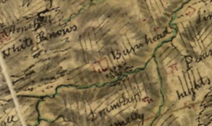
Roy’s map shows Burnhead surrounded by rig and furrow and in 1777 the Lands of Burnhead consisted of 42 acres, 3 roods, and 3 falls. Scots measure, of arable land, and 22 acres, 1 rood, and 9 falls of moss. The farm was then tenanted by John Main who paid £13.3.4, including the price of the kain. Kain, or kane, was a payment in kind, a portion of the produce payable as rent. In Slamannan parish this usually took the form of poultry or cheese. There was also a bank of natural wood adjacent to the dwelling, “fit for cutting, besides some well-grown planting” (Caledonian Mercury 5 July 1777, 4). The woodland is shown on the 1860s Ordnance Survey maps. No field enclosures had been created and very little drainage undertaken, meaning that the land was capable of improvement. The farm had been owned by the Tennant family for generations, usually having the Christian name John.
- 1624 John Tennant
- 1638 William Tennant (son)
- 1654 John Tennant (son)
- John Tennant
- 1781 John Tennant
This stability meant that the family invested in the property and particularly in the dwelling.
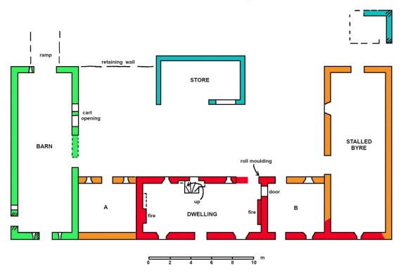
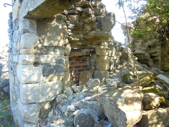
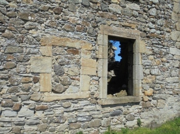
The 17th century dwelling was constructed with the locally available whinstone – some evidently rounded lumps derived from field clearance, but most made up of small split angular pieces. The margins were made of a relatively soft cream-coloured sandstone which was easily worked and must have been imported. The remnant of a doorway with a roll-moulded surround can be seen in the north-east corner of the two-storey block. Two small rectangular windows to its west have chamfered margins and mitred corners and belong to the same period. The south façade has a similar blocked up window just to the east of the main doorway and another in the south gable of the later byre. Lintels above the enlarged later windows of the main block also belong to this early house. The main block must have been of two storeys and contemporary windows occur in both gables. That on the west is in the attic; that on the east just above a connecting doorway with Room B. Where the building stepped down to the low single storey east wing (Room B and the southern part of the later byre) the roof raggle was marked by a serries of flat stones set into the gable. A long linear building, aligned west/east, half made up of two storeys and half of one storey would be typical of the 17th century.

A north/south barn was built to the west of the farmhouse. Its gables each had two ventilation slots and the southern gable was on line with the south wall of the dwelling.
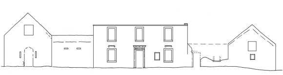
Sometime around 1770 the old house was remodelled into what the 1777 advert calls “a convenient mansion-house two storeys high” (ibid). The shell of this dwelling and its out-buildings still remains (2026) and it clearly had pretensions. It utilised the combined mass of the buildings to create an imposing south-facing façade overlooking gardens, with an enclosed courtyard to the north.
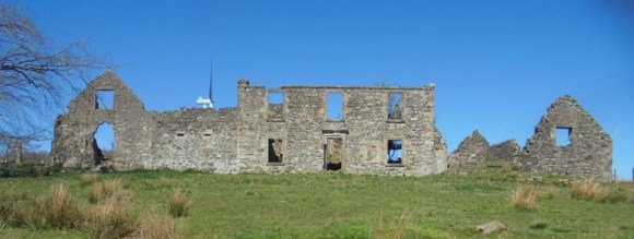
It consisted of a two-storey central block with the typical symmetry of the period – a central doorway with a sash and case window to either side and three windows above. Set a little away from this to either side were the gables of a byre and a barn, and these were joined to the main block by connecting bays (A and B). The door and window margins of this phase were made from a harder, larger grained, sandstone, neatly droved.
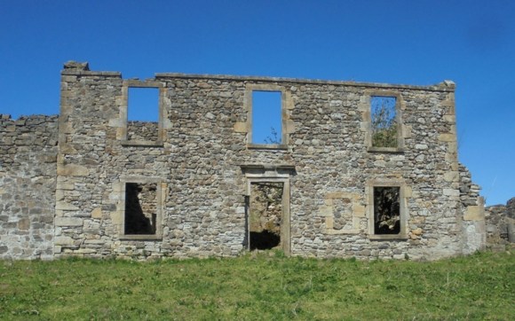
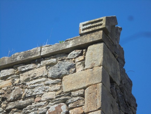
The windows on the main block enlarged the earlier ones and that to the right of the door was filled in to achieve symmetry. The new windows were given backset margins with the sills even more prominent so that they stood out against the harling which concealed the random rubble of the walls (the backset margins on the blocked window were taken back flush with the wall so as not to protrude through the harling). The roof would have been slated and was edged by plain skews with backset outer margins. The remaining skewput on the east has a rectangular sunken panel containing a horizontal rope design.
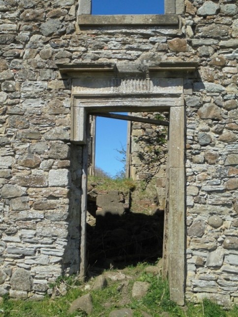
The doorway too was given special treatment in the prevailing classical style. It had a moulded architrave with a fluted frieze under a cornice.
Where did the money for this mansion come from? The Board of Trustees for Fisheries, Manufactures and Improvements paid premiums for the growing of flax from 1728 onwards and Stirlingshire became one of the main producers. Several lint pools are shown in the area on the 1860 Ordnance Survey map. The availability of water made the area particularly suited to flax growing but additional funds would probably have been needed. In 1781 John Tennant was in Jamaica when he was served as heir to his father of the same name and so it appears that the family had interests in a sugar plantation there.
The Tennant family were not to remain for long. By 1820 the farm, along with Wester Burnhead, was in the ownership of Robert Carrick of Braco. In that year he entailed his estates. He died the following year and Thomas Carrick inherited. Upon his death in 1836 Mr Carrick Buchanan took possession and applied to the Court of Session to disentail the estates of Drumpellier and Burnhead.
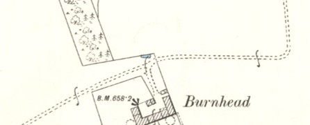
The Ordnance Survey Name Book of 1860 provides the following information:
“Easter Burnhead – A large farmsteading, dwelling house, two stories, office one, all slated and in good repair. Property of R.C.D.C. Buchanan, Drumpellier.
Wester Burnhead – A farmsteading, one storey, thatched and in good repair. Property of R.C.D.C. Buchanan, Drumpellier.”
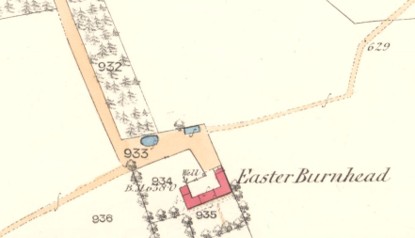
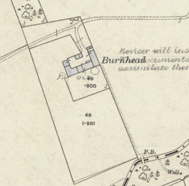
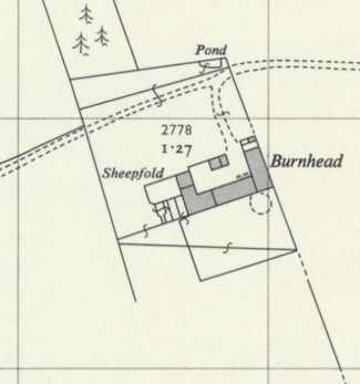
The maps of the Ordnance Survey provide a useful record of the changes to Burnhead. The 1860 map shows it almost as it had been at the end of the previous century – with a small lean-to shelter on the north gable of the byre. There were ponds to the north for the livestock which would have been a mix of sheep and cattle. By the time of the 1895 map one of these ponds had gone and the lean-to shelter had been extended by a small separate building of two compartments – probably a pigsty. A large building had been built on the north side of the courtyard. It had a large opening at the west end of the south wall and was evidently for a cart/waggon. More significantly, the circular platforms of two gin mills are shown – one to the west of the buildings adjacent to the barn, the other on the south side of Room B. The blocked up aperture for the drive shaft connecting the horse turning area to the internal machinery of the barn can still be seen, but the external platform has since been incorporated into a sheepfold with troughs. The second gin mill is more unexpected as it lay in the former garden area against the main façade and reflects the decline in status of the house.

Minor details can be made out in these maps, such as the lean-to shelter in the south-east corner of the courtyard to give dry access from the house to the byre.
A path from the south-east corner of the farm to a cart bridge and a footbridge over Drumtassie Burn has since disappeared. The 1913 map shows a well on the south side of the bridge.
Further west, on the south side of the burn, opencast mining in the 1980s has left a large hollow which is now occupied by a pond.
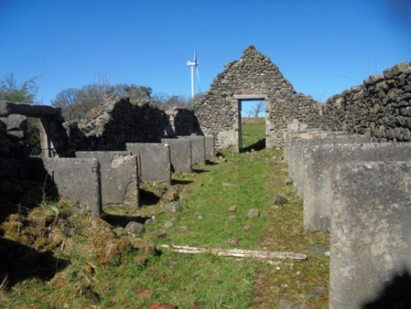
The sheepfold to the west of the buildings, already mentioned, appears of the 1961 map at which time the buildings were all still roofed. Subsequently large timber structures were erected to the north of the byre and in the courtyard as animal pens – probably after the abandonment of the stone buildings. In 2011 the whole area formed part of a proposed wind farm consisting of thirteen turbines 127m high to blade tip. These turbines appear on the photographs included here. The old farm buildings have been entirely abandoned.
Bibliography
NEWSPAPERS
- Caledonian Mercury, 5 July 1777, 4:
To be Sold by public roup, within the house of George Jarvey vintner in Bathgate, upon Wednesday the 20th August next, twixt the hours of one and two afternoon.- The Lands of BURNHEAD, consisting of 42 acres, 3 roods, and 3 falls. Scots measure, of arable land, and 22 acres, 1 rood, and 9 falls of moss, presently possessed by John Main, and paying of yearly rent, 13L.3s.4d Sterling, including the price of the kain at a moderate conversion, lying in the parish of Slamannan, and county of Stirling…
- There is on the Lands of Burnhead, a convenient mansion-house two storeys high, with a bank of natural wood adjacent to it, fit for cutting, besides some well-grown planting…
- Both farms can be greatly raises in the rent in the state they are presently in, being very low rented; but as no inclosing, or other improvement, has ever been made on these lands, they are capable of very great improvement…
- Caledonian Mercury, 13 August 1777, 4:
The Roup and Sale of the Lands of BURNHEAD, lying in the parish of Slamannan, and shire of Stirling; and of the Lands of MOSSSIDE, lying in the parish of Bathgate, and shire of Linlithgow, formerly advertised to be in the house of George Jarvey vintner in Bathgate, upon Wednesday the 20th of August inst, is adjourned to Wednesday the 24th next, and will then proceed at the said place. - Caledonian Mercury, 30 May 1842, 2:
Carrick v Buchanan and others. This was an appeal from a decision of the Court of Session, arising out of an action of reduction and declarator brought by the pursuer as heir of entail of the estate of Burnhead, in the county of Stirling, under a deed of entail executed by the late Robert Carrick of Braco, on the 18th of July 1820. The Lord Ordinary decided in favour of the reduction of the deed under which Thomas Carrick succeeded to the estate in question, which he held from the period of the entailer’s death in 1821, till his own, in 1836, but gave expenses to neither party. … - Caledonian Mercury, 13 June 1864, 4:
This is a petition at the instance of Mr Carrick Buchanan to disentail the estates of Drumpellier and Burnhead, under the third section of the Rutherford Act. The third section of the Rutherford Act applies to entails executed before 1848; but a number of the entails under which the lands of Drumpellier and Burnhead are held are dated after 1848. The lands were acquired (1) under contracts of excambion, (2) with compensation money paid for portions of the entailed estate taken by a railway company under authority of the Lands Clauses Act, the application of the money having been authorised by the Court…
