
A loch is simply a natural lake or pond; or a term given to an arm of the sea. They provide part of the background against which human activity took place, providing a source of food, building materials and entertainment. Wild fowl and fish were a useful supplement to the diet and the rights to harvest them were jealously guarded. Even leeches were taken from two of the local lochs for use in medicinal treatments. Reeds grew along the banks of the lochs and could be used for thatching. Many of the lochs were located in peat mosses and this was taken as fuel. Indeed, some of the lochs resulted from the hollows left by the extraction of peat and in some cases this led to disastrous land slips. None of the local lochs were particularly deep and the water on their margins quickly froze in the winter allowing curling to take place. This game was particularly popular in the early 19th century. At the end of the 20th century water skiing was taking place at the Black Loch.
Reid devoted a section of his place name book to the lochs of East Stirlingshire (Reid 2009, 184-187). Only a few of these now remain, many having been converted into reservoirs or drained as part of the agricultural improvements of the 18th century. Some of the place names associated with the lochs are:
- Lochbank – Callendar Loch (1781)
- Lochdrum – Loch Green (1742)
- Lochend – Tarduf Loch (1817)
- Lochend – Ellrigg Loch (1817)
- Lochend – Boreland (1695)
- Lochgreen – Loch Green (1664)
- Lochhead – Tarduf Lock (1724)
- Lochhead – Ellrig Loch (1724)
- Lochhead – Boreland (1699)
- Lochhouse – Black Loch
- Lochlands – (1826)
- Lochmuir – Black Loch (1690)
- Lochpark – Castlecary (1815)
- Lochpark – St Helen’s Loch (1860)
- Lochrig – Longridge or Black (1590/1620)
- Lochside – Ellrigg Loch
- Lochstank – Black Loch (1806)
- Lochstank – Ellrig Loch (1784)
The two largest of the lochs were the Black Loch at Limerigg and Ellrig Loch south of Shieldhill. In both of these cases their original sizes are uncertain, but they are shown on Pont’s map of the 1570s as large bodies of water. The Black Loch was enlarged in the 1780s to 124 acres by the construction of an earth embankment on its south-east side across the North Calder Water so that it could store more water for the use of the Forth and Clyde Canal. Ellrig Loch was at one time said to have been 50 acres in extent. It had a much more chequered history, being completely drained in 1896 to allow the coal deposits underneath it to be worked. It had been intended to convert the land it occupied into arable but this was abandoned and the loch was restored. To its north a combination of coal and peat working has left large hollows which are now filled with water and, although not officially named as lochs, could be considered as such.
St Helen’s Loch near Bonnybridge was also greatly modified to serve as a mill dam in the 18th century, whereas many such dams were constructed from scratch at that time and form significant stretches of open fresh water. The largest of these were the Carron Dams for the large ironworks there. The main or Wester dam covered an area of 31 acres and was an average of 3ft deep, giving it a capacity of 26.8 million gallons of water; the Forge Dam was 5.5 acres in size, and being 8-9ft deep held 13.1 million gallons (Watters 1996, 83). The Wester Dam made use of an existing hollow which was probably the result of peat extraction to provide fuel for the adjacent 16-17th century pottery. It had to be lined with clay to prevent seepage. Two small ponds were also created along the line of the lade to the west of the works and one of these was colloquially known as Lamond’s loch. Another large reservoir was formed at Dunipace but was abandoned after a short period due to a dispute over the ownership of the land. It slowly silted up and today provides a haven for wildlife – but was never known as a loch.
The large reservoirs and modified lochs used for the supply of drinking water to the population of the Falkirk area have been covered in a treatment of that essential of life. The list below is of the lochs – natural and misnamed manmade entities.
- Black Loch (Slamannan) (SMR 2016)
- Black Loch (Bonnybridge)(SMR 2178)
- Callendar Loch (SMR 1405b)
- Ellrig Loch (SMR 1686)
- Gairn Loch (SMR 830)
- Loch Green (and possible Crannog) (SMR 530)
- Muirhouses Loch (SMR 1440)
- Redding Loch (North & South) (SMR 258)
- Rumford Loch (SMR 832)
- St Helen’s Loch (SMR 2244) (see Elves, Saints and Distilleries)
Blind Loch
NS 850 702
In 1861 Auchengray Moss, to the west of the Black Loch near Slamannan, (SMR 2016) became saturated by heavy rains and the water got between the moss and the underlying clay.

In 1861 Auchengray Moss, to the west of the Black Loch near Slamannan, (SMR 2016) became saturated by heavy rains and the water got between the moss and the underlying clay. One account (Duns 1862 referenced in Reid 2009, 186) refers to the Blind Loch and says that forty years before the movement it had become covered with reeds, rushes, horsetails and bog mosses. This sounds like it may actually have been a flooded area of moss rather than a fully fledged loch and it is useful to note that in Scotland such wet moss was often referred to as a blind loch, blind in the sense of hidden. However, near Arbroath there was a Blind Loch used for skating in the winter, though it too appears to have been very shallow and was soon drained.
.
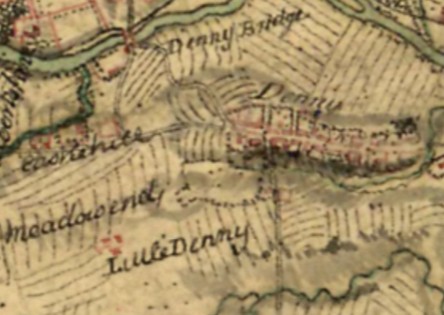
These dwellings would have lain on the east bank of the lost loch and its shape can be seen by the boundaries of the two fields to their west which were lined with trees.
This same enclosure can be made out on Roy’s map of 1755, where it is shown as a tree-lined blank patch surrounded by ridge and furrow. A small enclosure tacked on to its south-west corner contained a steading called “Meadowend.” This suggests that already by the mid 18th century the loch had been drained and provided a good quality meadow.
Boreland
NS 810 824
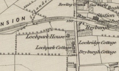
A lost loch is indicated at West Boreland in Denny by the presence of place names such as Lochend found as early as 1695, Lochhead in 1699 and “North Laike” in 1724. Later we get a row of large houses along the western side of Glasgow Road called Lochpark House, Lochridge Cottage, Lochpark Cottage and Dryburgh Cottage.
.
The location of this lost loch is a little odd. It sits on raised ground between the Sclanders Burn to the north and the Little Denny Burn to the south. The drainage of the central part of this plateau, however, was isolated and gave rise to the shallow loch.
Lamond’s Loch
NS 869 821
The Carron Dams which helped to power the Carron Iron Works were fed from the River Carron by a lade which started just below Larbert Parish Church. This was built in 1760 and consisted of a ditch with embankments.
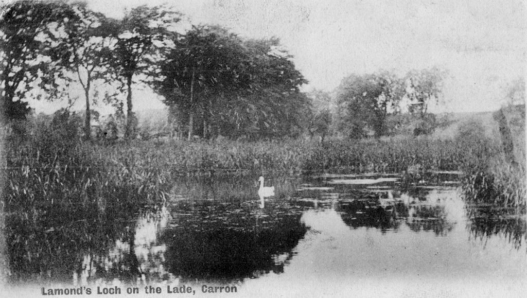
Where it crossed the Broomage Burn an aqueduct was constructed to take it across the valley and over the stream. That bridge gave way in April 1778 and took away part of the embankments; much water was lost. The entire water system was temporarily closed and much money was lost. The Carron Company made an agreement with Sir Michael Bruce of Stenhouse and Alexander Brown of Broomage to purchase the ground “up to the surface level of the water in the lade” and to use some of the water from the burn for the works (Watters 2010, 81). A small pool was created on the purchased ground. The pool became known as Lamond’s Loch, presumably after the tenant of the neighbouring land. It was, however, entirely artificial. It became redundant by the 1890s and was abandoned and allowed to slowly silt up. No trace of it is now visible.
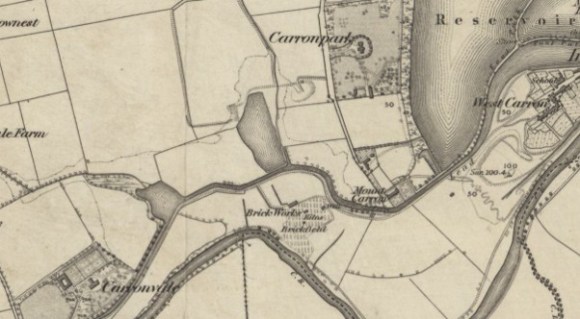
On the right are the Carron Dams (reservoir); in the centre a small reservoir on the Spout Burn; and on the left Lamond’s Loch in the Broomage Valley.
Laurence Loch
NS 869 821
This pond (NS952 776) appears on an estate map of 1832 (RHP 12531) and was removed by the construction of the Edinburgh to Glasgow Railway (Reid 2009, 185). The estate was created by Thomas Learmonth in the late 1820s. Laurence Park was the name of his former residence in Edinburgh and the name, like the loch, was imposed at that time. The area is still prone to flooding.
Lochs of Airth
NS 898 858
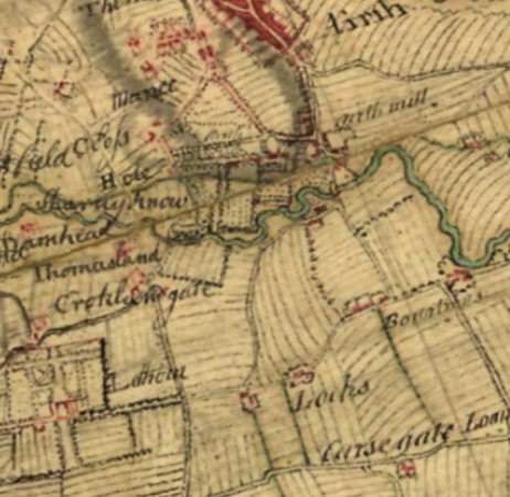
“Lochs of Airth” farm stands just to the east of the modern village of Letham, immediately to the north of the M876. It is called simply “Lochs” on the Roy map of 1755, which shows all the in the area fields as arable. This is a relatively flat area of carseland and this makes drainage difficult. It is therefore easy to see how pools of water could have formed. Today the land is criss-crossed by a series of deep drainage channels dug through the soft upper deposits and these must have their origin back in the 17th and 18th centuries, explaining how the loch[s] was/were lost at an early date.
.
.

Lochlands
NS 858 818
At first glance the name “Lochlands” in the lands of Carmuirs would suggest the presence of a loch. The first appearance of the name is on Grassom’s map in 1817 and refers to the farm located at what is now the southern end of the railway viaduct. The lands associated with the farm have sand and gravel substrata which are free-draining.
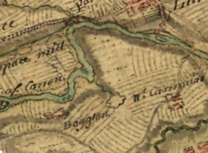
In the Roman period they were occupied by a series of temporary camps and so it is unlikely that there was a loch there. To the east, in the valley of the Lightwater Burn, was the large millpond of Lord Alexander’s Mill and it may have been this feature which is being referenced – loch then being a preferable term.
To the south-west is Bogton whose fields lie on the low land adjacent to the River Carron and are, as the name suggests, prone to flooding. Roy’s map shows a boggy area, or possibly a lochan, between it and Lochlands and this is another possibility for the origin of the name.
Lochpark
NS 794 786
A small body of water shown to the north of Allandale on an estate plan of 1815 is called “Lochpark” (RHP 6102). It lay immediately to the south of the Forth and Clyde Canal and Reid considered that the canal had cut it (Reid Notes). However, another plan (RHP 6103) seems to indicate that the pond was a flooded gravel quarry or an earlier clay pit known as “Pig Holes” because of an association with the making of pottery. Indeed, it is possible that in this instance the Lock element of the place name is derived from the canal and the “park” element of the place name suggests a late origin. In any case, it lay on the flood plain of the Bonny Water and so cannot claim to be a loch proper.
Tarduf Loch
NS 9506 7587
A small row of cottages at the Loan in Muiravonside parish was called Loch-head and appears on the 1860 Ordnance Survey map. It is an indicator of the former presence of a small loch (Reid 2009, 186) on Tarduf Muir. That muir was divided in the period 1814-1820 and the map showing the proposed allocation of the parcels of land which it contained shows the loch, and the cottages (not named but shown in red). The loch was evidently drained as part of the “improvements” which occurred after the division and had completely disappeared by the time of the 1860 Ordnance Survey map.
.
.
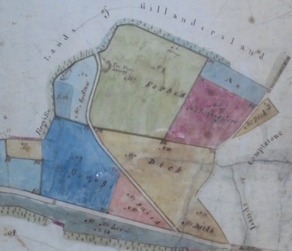
The first surviving record of Loch-head was in 1724 which suggests that this was a natural loch. The loch is not named in the record and the name given here is assumed.
.
Illus: Roy’s Map (National Library of Scotland).
Whiteside Loch
NS 9375 7823
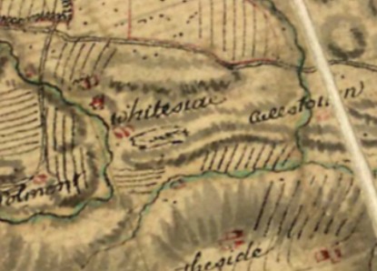
Recorded as “Whytesyd Loch” in 1664 (Reid 2009, 185) it was to the south-east of Polmont, but its exact location is not known. Roy’s map of 1755 shows a small area of moss to the south-east of Whiteside House and this probably represents the drained remnant of the loch. Its position, adjacent to the west-east esker, is analogous to those at Redding and Gairn.
Bibliography
| Duns, J | 1862 | ‘On a Recent Landslip,’ The Edinburgh New Philosophical Journal, XIV, New Series. |
| Reid, J. | 2009 | The Place Names of Falkirk and East Stirlingshire. |
| Watters, B. | 1996 | ‘Water power at Carron Ironworks,’ Calatria 9, 75-84. |
| Watters, B. | 2010 | Carron: Where Iron Runs like Water (2nd ed). |

