
SMR 832 / NS 9315 7739
A major road intersection occurs at Rumford where Sunnyside Road (formerly Roughhaugh Road) meets the Maddiston Road, Quarry Brae Road, South Craigs Road and Comely Park Place (originally a service road to a brickworks). It is not surprising that the land on the southern side of this junction came to be considered as common land by the local people who walked across it as a short cut. It was used as open grazing with the tenants of Crossgatehead and Roughhaugh Farms taking advantage of it, as did tryst droves, travelling tinkers, and small crofters. It covered 105 acres and was part of Whiteside Moor, sometime known as Craigsmuir.
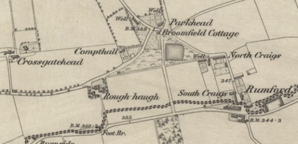
Around the year 1840 the local population got together and constructed a shallow pond in the area, many contributing physical labour to dig the hole and others bringing in stones for the embankment. The pond was used for watering animals and as an emergency water supply in the dry summer months – the muddy water being reserved for washing and cleaning. Water for drinking came from a well at the eastern apex of the muir called Craigs Well. In the winter the pond froze over and was greatly appreciated as a communal recreational facility for skating and curling. It came to be affectionately known as “Rumford Loch.”

However, there was never any formal acknowledgement of the public ownership of this piece of land. There was no public corporation or community body established to oversee its use, no title deeds or dominant tenant. The Napier family who owned Crossgatehead from the 1860s claimed proprietorship of it, as did the Duke of Hamilton. Napier feued out land to the west of the service road – the first dwelling being Broomfield Cottage, built for James Josh, who had made his money on the Paisley Water Contract.
In 1890 William Cameron bought Crossgatehead from Mr Napier’s trustees. The boundary to the south was a stone dyke which divided it from Roughhaugh. The eastern boundary in the area of the so-called common was less clear. It appeared to him that the service road which had been constructed across the common to give access to a brickworks had divided an existing larger field. He subsequently feued the land on the west side of the service road and four new dwellings had appeared by the time of the 1895 Ordnance Survey map.
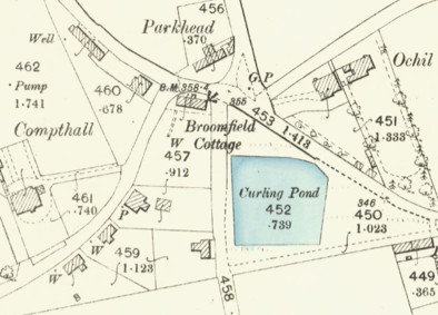
In 1891 Cameron leased out the land to the east of the service road to John Tweedie of Dunhalin. He soon fenced the loch, ran off the water, and planted shrubs. Some locals considered that he had improved the appearance of the place, but most were horrified at their loss of a public amenity. This became particularly apparent during the winter frosts when normally they would have been skating. Many were indignant that the well had previously been filled in by the County Council as unsafe, making supplies from the pond more important. Consequently, in February 1892 an open meeting was called with Robert Myles as chairman. He had written to the County Council but their clerk did not consider it a case for them to deal with. A law agent was also consulted, and he stated that if the loch had been held by the public for skating and curling for the period of forty years, they had a right to it. At the well-attended public meeting Peter Brand called for the loch to be reinstated and it was agreed to take direct action by pulling down the wooden fence which interfered with the entrance, and to call upon the proprietor to return the stones taken from the loch. Accordingly, several hundred of the inhabitants of all ages and sexes met at the site on the following Monday evening, many having provided themselves with spades, picks, and crowbars. About thirty yards of fencing were destroyed in a few moments, allowing passage from east to west. Small lengths of the trenches which had been dug to drain the water from the loch were also filled in, although the ground was hard, and was covered with snow.
Nothing had been done immediately by the proprietor or lessee to repair the fences which were torn down and about a week later a number of the inhabitants returned to dig the turf which had grown upon the site of the loch since it was closed against the public. A further public meeting in May was held in the Co-operative Hall, Redding, attended by the Falkirk Trades Council and it was agreed to raise money to test the case in law. Cameron applied for an interdict against Patrick Baird and others to stop further actions on the ground. This was granted to allow him time to prove his ownership of the ground, and to allow the defenders proof relating to the alleged right of way through the ground. The sheriff stated that it was only the right of way that the public could defend as they clearly had no title to the land. The case was hear that June and ended up preserving the right of way, but not in gaining public ownership. Cameron was ordered to pay expenses to the defenders as he could not prove ownership of the land to the east of the service road to the brickworks. The pond was reinstated and appears on the 1895 map as a curling pond.

By 1913 Crichton Place had been built to the north of the curling pond and it appears that the Duke of Hamilton had asserted his rights to the ground. The pond was allowed to remain for the meantime.
In the depression of the early 1930s Father McGarvey of the Rumford Roman Catholic Church arranged for a project to provide some employment to those out of work. A large presbytery was erected for St Anthony’s on the site of the then disused curling pond. The site cost £43.00. Much of the work was supported by the congregation – the ladies providing meals for the workers. An adjoining church hall was opened in 1931.
Bibliography
NEWSPAPERS
- Falkirk Herald, 24 February 1892, 5:
Another right-of-way dispute has occurred at Polmont. It appears that some time ago Mr John Tweedie of Dunhalin acquired some vacant ground, including Rumford Loch. The people in the neighbourhood hold that the loch is common property, it having, they allege, been obtained about 50 years ago by public subscription, and has, until the present season, been used by the public for skating and curling. It is also stated that in summer, when water was scarce, the people obtained supplies from the loch for cleaning purposes. The ground on which the loch is situated belonged to Mr Cameron, farmer Crosgatehead, who recently feued it to Mr Tweedie. Since obtaining possession of the land, mr Tweedie has fenced the loch, run off the water, and planted shrubs. A meeting of the inhabitants was held last Friday evening to consider what steps ought to be taken in the matter. The chairman (Robert Myles) stated that the clerk of the County Council had been written to regarding the running off of the water, and had replied that it was more of a right of way case than a matter which required the attention of the County Council. A law agent was consulted, and he stated that if the loch had been held by the public for skating and curling for the period of forty years, no one could interfere. Mr Paterson, Crossgatehead, held that as Mr Tweedie had feued the ground, the public had no right to it. Since Mr Tweedie had drained the loch and otherwise improved it, it was a credit to the place, whereas it had formerly been a disgrace. A motion by Pater Brand, to fill up the loch and to pull down the paling which interfered with the entrance, and to call upon the proprietor to return the stones taken from the loch, was carried, only five favouring a deputation meeting Mr Tweedie. It was also agreed that the inhabitants meet on Monday evening for the purpose of carrying the motion into effect.- On Monday evening several hundred people gathered in the vicinity of the loch. A good number had provided themselves with spades, picks, and crowbars, which they utilised in digging up the fences which obstructed the passages from the east and west, and in partly filling up the trenches which had been dug for the purpose of draining the water from the loch. About thirty yards of fencing were destroyed in a few moments, although the filling up of the ditches was a more difficult task. The ground was hard, and was covered with snow; but those of the public present seemed satisfied with only a portion of the ditch having been filled up in the meantime. The men received not a little assistance in their efforts from a worthy old dame of nearly 70 summers, who seized the pailing and pulled away with even greater zeal than her male companion in the struggle. Not a little amusement was occasioned, however, when, after frequent unsuccessful attempts to pull down the eastern fence, and after an unusually strong pull, the pailing suddenly gave way, landing those who were engaged on their backs amongst the snow. The old lady was on her feet in an instant, and received, together with the others, a hearty cheer…
- …some people will require to bring back the stones they have upon their milk-house floors, and place them where they were before in the loch…
- Edinburgh Evening News, 3 March 1892, 3:
A number of Polmont and district inhabitants met today at Rumford Loch for the purpose of digging the turf which had grown upon the site of the loch since it was closed against the public by the lessee. Nothing has been done by the proprietor or lessee to repair the fences which were torn down by the public about a week ago. - Falkirk Herald, 25 May 1892, 6:
A public meeting in connection with the Rumford Loch dispute was held in the Co-operative Hall, Redding, on Wednesday evening. Robert Myles occupied the chair, and was supported on the platform by Mr Chisholm-Robertson, and Mr W, Strang of the Falkirk Trades Council… money to be raised to test the case in law. - Falkirk Herald, 4 June 1892, 4:
The Rumford Loch Dispute. —At Falkirk Sheriff Court on Monday—Sheriff Scott-Moncrieff on the bench—the action for interdict at the instance of Mr Cameron against Mr Baird and others was called for adjusting and closing… continuation of the diet… - Falkirk Herald, 13 August 1892, 5:
THE RUMFORD LOCH DISPUTE. In the action for interdict the instance of Cameron, farmer, Crossgatehead, Polmont, against Patrick Baird, senior, and others, the Sheriff-Substitute sometime ago issued an interlocutor, allowing the pursuer proof relating to the ownership of the ground in question, and allowing the defenders proof relating to the alleged right of way through the ground… requires a dominant tenant, corporation or community… - Falkirk Herald, 29 October 1892, 5:
The Rumford Loch Dispute. Crossgatehead claimed the land on the east side of the pond known as the Rumford Pond… William Cameron bought the property in 1890 from Mr Napier’s trustees. The boundary to the south was a stone dyke which divided it from Roughhaugh. He feued the land on the west side of the brickwork service road, but not the pond and the land to the east.- Land called Whiteside Moor, claimed to belong to the farm of Crossgatehead. People crossed the land to get to the pond.
- …Mr Allan, witness denied that he had told a man that he had seen a plan in which the ground in dispute appeared as commonry. James Lawrie, 71 years of age, residing at Polmont, stated that be remembered the pond being made. Before the pond was made the ground was not used by anyone… it was about fifty years ago that the pond was made…
- People water their cattle there; the pond had been made by the public.
- James Rae, Craigs, had no other access to his home than over the ground in question.
- Craigsmuir.
- 105 acres.
- Falkirk Herald, 19 November 1892, 5:
Mr Cameron, the Pursuer, ordered to pay expenses to the defenders as he could not prove ownership of the land to the east of the serve road to the brickworks. “there is also evidence, which indeed exists to this day, that his neighbour ‘Roughhaugh’ took in and planted another part upon the same side. Much importance cannot be attached to the fact that tryst droves, travelling tinkers, and small crofters were occasionally ordered off the ground in question when found pasturing; one of the pursuer’s own witnesses looked upon it as open grazing ground for all, and in particular, there is evidence that the Roughhaugh cattle pastured there…. Ground claimed by the Duke of Hamilton…

