
SMR 2178 / NS 840 783
Lochrig, which is mentioned as early as 1620, refers to a small loch which lay to the south of Bonnybridge (Reid 2009, 134). It matches with the location of “Blak L:” depicted on Pont’s map c1590. In the past this has been confused with the Black Loch to the south of Slamannan.
The name Lochrig occurs on Roy’s map of 1755 for a steading, which fixes the location to the west of Greenrig. Neither it nor Grassom’s map of 1817 show the loch, and by the time of the latter even the steading had disappeared.
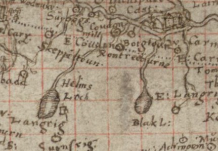
Pont’s map shows that the outlet from the loch flowed into the Rowntree Burn and then the Bonny Water before joining the River Carron. We are therefore justified in placing the loch in the amorphous patch of moss depicted within Drum Wood on the first edition Ordnance Survey map.
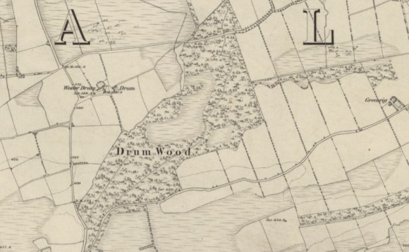
In size this Black Loch was a little smaller than St Helen’s Loch. Like Loch Green it also took on the name of the neighbouring steading and in 1723 Johnston of Kirkland refers to is as Lochrig. Having noted the loch at Lochgreen he says “a short mile east of this is another loch called Lochridge but it is not so big.” There is no suggestion that it was filled in or deliberately drained and it probably naturally silted up. Trees were planted on and around it in the 18th century by William Forbes of Callendar. These were a cash crop but on this marginal land they were more advantageous for the encouragement of game birds, bringing in money from shooting rights, and also incidentally giving rise to poaching.
Bibliography
| MacFarlane, W. | 1906 | Geographical Collections Volume 1; Johnston of Kirkland. |
| Reid, J. | 2009 | The Place Names of Falkirk and East Stirlingshire. |

