
SMR 1440 / NT 013 807
The small loch to the west of Muirhouses in the parish of Carriden was for long commemorated by the name “Lochend” applied to a small cottage. The Ordnance surveyors in the 1850s described it as being “one storey high with vegetable garden and a few acres of land attached. Occupied by Miss Baird, proprietress.” By then the loch had long been drained and its existence slowly passed from the collective memory, though Salmon refers to it in 1913.
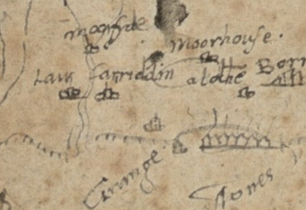
The old name of the loch is not known but it appears on one of Timothy Pont’s earliest sketch maps, dated around 1570, simply as “a loche.” This is one of his crudest sketches, but we may be safe in assuming that the elongated oval next to the annotation indicates that the sheet of water was of a fair size. The loch stood in the fold of the hills between Drum and Northbank Farms and the water exited to the east by the Carriden Burn.
Lochend was built on a slight rise which blocked the east end of the loch. The shape of the loch is reflected in the road system shown on the 1854 Ordnance Survey map. Acre Road runs west from the village of Muirhouses and follows the south side of the loch before turning sharply north, passing the Kiln Pit heading for Grange. The north side of the loch is delineated by a slightly curving ditched field boundary. This encompasses an area of 16 acres.
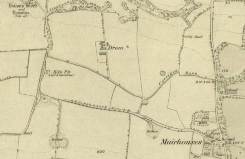
Draining the loch would have simply involved cutting the Carriden Burn deeper into the ridge north of Lochend. This was done at an early date, probably in the early 18th century, to enable the coalfield to be exploited. Mary’s Hole Pit (seen as a pond north of the Carriden Burn on the 1st ed. Ordnance Survey map) was opened well before 1770, The Old Engine Pit (later called Miller’s Pit) in 1758, the North Pit (later called Kiln Pit) around 1764, and Acre Hole Pit before 1784.
During trial excavations which showed that the Antonine Wall did not pass through this area, the basal silt of the loch was encountered. This work indicated that the loch was little more than 5-8ft deep.
Gauze
The Carriden Burn begins in the area of Kinglass and Gauze. Springs to the east of Gauze Road and Kinglass Park give rise to a marshy area which was examined in 2022. Grey silty material up to 0.3m deep was deposited over centuries in stagnant water. This site was explored (at NT 0041 8113) because it lay immediately to the north of a Roman temporary camp and separated it from the Antonine Wall. There are two possible meanings of “Gauze” – (1) a barren or unfertile spot in a field, through which springs of water constantly ooze up; wet, spongy land; (2) a channel or small trench made for drawing off water (Macdonald 1941, 36). Given that the place name appears in 1669 in the plural form of The Gawes, the first interpretation is the more likely in this case.
This note is included here because Salmon suggested that Gauze may represent another loch, similar to the nearby one at Muirhouse, but this is doubtful.
Bibliography
| Bailey, G.B. | 2022 | Archaeological Survey at Kinglass Roman temporary camp |
| Macdonald, A. | 1941 | The Place-Names of West Lothian. p.36 – “Gauze is Gallis 1631 Ham. Inv. Gavis 1667 Dund. B, Gaws 1669 Ham. Inv., (The) Gawes 1669 Reg. Bor. Cf EDD Gaw, sb., 1. A channel or small trench made for drawing off water. Also EDD Gall, sb., 6. A barren or unfertile spot in a field, through which springs of water constantly ooze up; wet, spongy land. Gen. in pl. The second is the more likely; but the land belonging to this farm lies mainly in a hollow, through which runs a small stream. The first interpretation, therefore, cannot be ruled out. |
| Salmon, T.J. | 1913 | Borrowstounness and District. |

