
SMR 231 / NS 8594 8185
Listed C
The River Carron was a major barrier to movement and on several occasions Scottish armies faced each other on opposite banks without coming into conflict – such as James II and the Scottish rebels in the 1480s, and James VI and his rebels in 1578. River crossings such as fords and ferries, and bridges in particular, therefore assumed strategic importance. That there was a ford at Larbert is demonstrated by the place name “Red Brae” referring to the road leading to it from the south. Later the “King’s Ford” is also mentioned. The date of the first bridge at Larbert is far from certain.
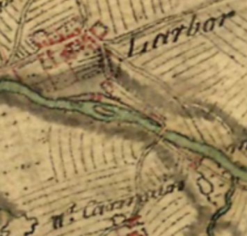
A bridge is believed to have been built in the vicinity of Larbert during the Roman period on the line of the road from Camelon to Perth. This road continued in use for some time, but had been thoroughly removed by the latter half of the eighteenth century with only vestiges remaining, as attested by Nimmo in 1777. Nimmo had first hand knowledge of the discovery of the probable remains of the bridge.
“The place where it had crossed Carron is now a frightful precipice; but the steep banks upon the south-side appear plainly to have been sloped, and the rock at the water-brink to have been cut. No vestige of any bridge was observed till summer 1773, when workmen, employed by the Carron company to make a reservoir to the use of their works in that very part of the river, digged up several of the foundation-stones; but, whether an arch of stone had been thrown over the river, or the bridge had consisted only of wooden beams, supported by stone pillars, is quite uncertain”
(Nimmo 1777, 15).
In recent years the location of these remains has been questioned because the weir which fed the Carron Company’s reservoir at the ironworks is immediately to the south of Larbert Parish Church, whereas the Ordnance Surveyors in 1858 placed the Roman bridge well to the west. However, this is based upon a misunderstanding as the reservoir in question in 1773 was at Dunipace (Watters 1996, 77) even further to the west. The river at the point shown by the Ordnance Survey was being deepened as part of the programme of water management. This is confirmed by the notes made by the Ordnance Surveyors
“In the year 1773 when the Carron Company was deepening the bed of the river the workmen came upon the piers of this bridge which was of stone fastened with Roman cement. There is not a vestige of the bridge at present but its site is well known.”
Their short note adds extra information and shows that they had gleaned additional local knowledge.
Robert Lindsay, known as Pittscottie, writing around 1575, mentions a bridge over the Carron Water where the forces of James II and the Earl of Douglas faced each other (Mackay 1899, vol 1, 118, 206). Whilst it has been suggested that this may have been Larbert Bridge (RCAHMS 1963, 413), it seems more probable that it was the structure at Denny that was being referred to. Timothy Pont shows the bridge at Denny on his map of c1585 but no such crossing at Larbert. By 1651 there was definitely a bridge at Larbert and such was its importance that it became the locus of a difficult engagement when Cromwell tried in vain to dislodge Charles II (Bailey 1992). Johnston states that a battery of cannon was placed at Castlehill for the defence of the bridge and ford by the Royalist army (Johnston, 1723). That the incident was serious and the artillery effective is suggested by Thomson’s collection about Colonel Wemyss’ patents for inventions in artillery which schedules “mortar pieces” and says
“sufficient experience whairof was seen at Gogar feight, Lerberbridge and elswher”
(Thomson’s Acts Vol. vii, p47).
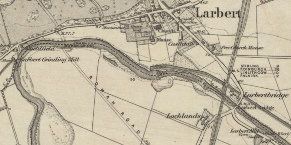
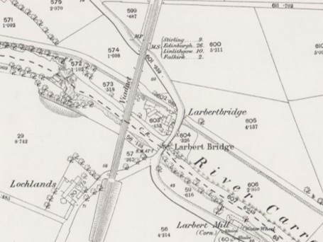
The bridge at this time probably stood at the bottom of the Low Town of Larbert, a little to the west of the later railway viaduct. In 1664 the Falkirk Kirk Session noted “the defectes of the bridgge of Lerbert” and collected £29 16s Scots for its repair. The bridge was evidently built by one of the Livingtones of Callendar (Livingston 1920, 129).
The bridge at Larbert appears on Roy’s map of 1755. It is approached from the south by two roads – one from Carmuirs and the other from Camelon; the former lies to the west of the present Carmuirs Loan and it is evident that its move occurred after the rebuilding of the bridge in 1782. The Carmuirs route was originally the main road. North of the bridge the road took a right-angled turn to the west, following the north bank of the river to Larbert Low Town before ascending the hill diagonally.
In 1707 Parliament passed an “Act in favour of James, Earle of Linlithgow and Callendar, for a toll on the bridge of Larbor for 22 years.” The Act is in these words:
“Our Sovereign Lady the Queen’s Majesty and the Estates of Parliament considering that the bridge of Larbor upon the water of Carron was built by the Earle of Linlithgow his predecessors upon their own charges, and being upon the highway and publect road from the west to Edinburgh and from the north to the south parts of the kingdome, the said bridge and wayes and cassayes leading to and from the same, and the caussay of the Town of Falkirk belonging also to the said Earle, are much damnified and impaired by the continual passing of carts and loaded horse, and requires a considerable expense to uphold and preserve the same for the commone benefite and advantage of the liedges, therefore Haer Majesty with consent of the Estates of Parliament appoints and allows four pennies Scots for each cart, two pennies for each loaded horse, and twelve pennies Scots for each score of all droves of cows that shall pass along the said bridge of Larbor or town of Falkirk, to be exacted and uplifted by the said Earle of Linlithgow or those Commissioners be him. To be employed for preserving, repairing, and upholding of said bridge, ways cassays of Falkirk, and that for the space of 21 years after the date thereof.”
The bridge had two stone arches (Johnstone 1723). In 1733 flooding destroyed two bridges on the Carron, one of which was presumably Larbert Bridge (Love 1908, p.2). Another bridge, again of two arches (RHP 1496), was then constructed for in 1956 the Royal Commission noted the remains of an early eighteenth century bridge abutment next to the present stone bridge at Larbert (RCAHM 1963, 413). This bridge and the corresponding roadway were at a lower level than the later bridges. The access to the bridge was altered in 1761 as a result of the construction of the large lade to the Carron Dams. The road which had previously led from Larbert Cross to the King’s Ford via Castlehill was diverted to the bridge. The medieval motte at Castlehill was demolished “by the great road from Stirling, which stretches that way” (Nimmo 1777, 15).
In 1755 and 1758 the bridge was described as in great disrepair (Falkirk Archives a1.452). The bridge, now on the turnpike road between Falkirk and Stirling, was extremely narrow and in 1781 it was discovered that the foundation had failed and one of the arches rent (Edinburgh Courant 4 August 1781; Caledonian Mercury 4 August 1781, 1; Love 1908, 8).
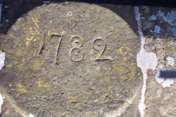
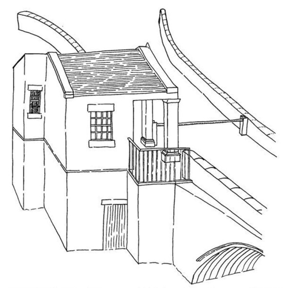
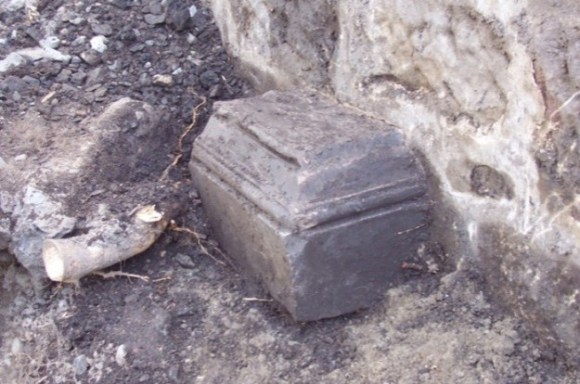
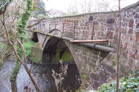
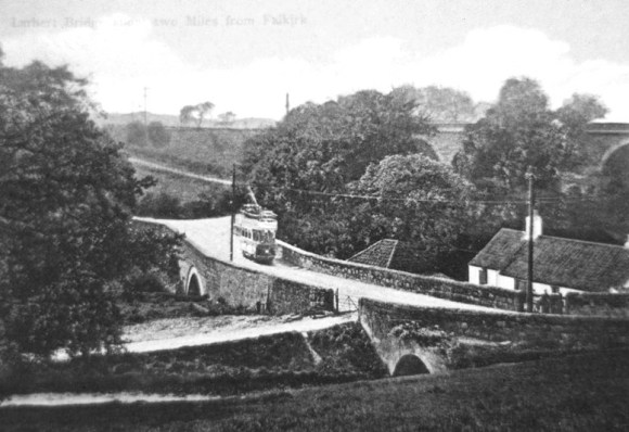
The following year a new bridge was completed and is still standing. It bears a roundel inserted in the north-west parapet towards its south-west end inscribed “1782,” and the feebly carved initials “T.A.” Including the approaches, it is 56yds in length and is 27ft wide over its parapets. It is carried by two arches, the larger one to the south-west spans the main channel of the river (c44 ft) and the smaller one to the north-east provides a passage for floodwater. The pier has a splayed and pointed cut-water both upstream and downstream. The arches are defined by drip-moulds. The 1782 bridge was still subject to tolls and in 2009 a pilaster of the tollhouse was observed near to the north-west end of the bridge (Bailey 2011)
Tolls were removed from the roads of East Stirlingshire in 1880 (Ballantine 1998), though that at Larbert Bridge had gone long before that – hence why it is not named as such on the 1st edition Ordnance Survey map.
Thereafter the upper storey of the tollhouse was removed and the lower portion served as a store. It can be seen on a photograph taken around 1907.
The building itself was only demolished sometime between 1920 and 1940. The rampart was made good leaving little trace of its former existence.
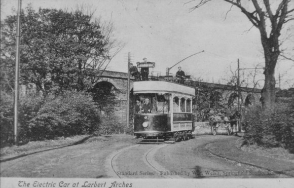
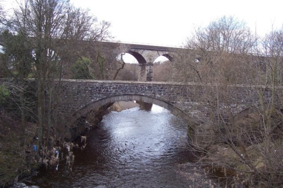
In 1905 steel tracks were laid over the bridge to take tramcars of the Circular.
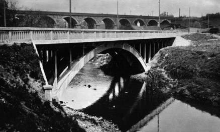
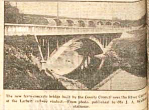
In 1924 the County road surveyor advised that the difficult corners associated with Larbert Bridge could be overcome by building a new bridge on the skew to the east. The project was deemed too expensive and was initially shelved, but it soon became apparent that it might qualify for a government subsidy to provide employment. It was April 1925 before the Ministry of Transport agreed to give a grant of 75 per cent of the estimated cost of £36,000. The ferro-concrete bridge over was completed in October 1926 and successfully passed the load-bearing tests. The tramway was immediately transferred to cross it.
Bibliography
| Bailey, G.B. | 1992 | ‘Along and Across the River Carron: a history of communications on the lower reaches of the River Carron,’ Calatria 2, 49-85. p80-2. |
| Bailey, G.B. | 1992 | The Incident at Larbert Bridge and the Siege of Callendar House, 1651.’ Calatria 3, p9-28. |
| Bailey, G.B. | 2011 | ‘The Tollhouse at Larbert Bridge,’ Calatria 27, 107-112. |
| Johnston | Two short miles west of Fallkirk upon the publick road is the Lightwater burn, which rises out of the marishes besouth the highway. It runs north and falls into Carron a little below Larbert bridge upon the Stirling road where it has a bridge of one arch called Panmeadow bridge. At the north end of Larbert bridge is a little mount where was a batterie of cannon in defence of the bridge and ford, when King Charles the Second his army lay in the muirs of Dunipace and Larbert 1651. | |
| Love, J. | 1908 | Local Antiquarian Notes and Queries. Volume 1. (Quoted at (1) below) |
| Livingston, E. | 1920 | The Livingstons of Callendar and their Principal Cadets. p.129 “…in the reign of Queen Anne, by one of the last Acts passed by the parliament which voted the Union Act, he obtained the right to levy tolls on the Bridge of Larbor upon the Water of Carron (1707) for the space of twenty-one years, owing to the bridge having been built by one of his predecessors in the title, and to meet the heavy expenses incurred in keeping it in proper repair.” |
| Nimmo, W. | 1777 | A General History of Stirlingshire, p.15 (Quoted at (2) below) |
| Pittscottie – Aeneas Mackay | 1899 | The historie and cronicles of Scotland: from the slauchter of King James the First to the ane thousande fyve hundreith thrie scoir fyftein zeir, 3 vols, Scottish Text Society. |
| James III | 1480s | Carron (Charrane) water i. 118,23; 206,11. James III. (Quoted at (3) below) |
| RCAHMS | 1963 | Stirlingshire: An Inventory of the Ancient Monuments. (Quoted at (4) below) |
- Local Antiquarian Notes and Queries. Volume 1.
“While on the subject of bridges and bridge builders, a word regarding that of Larbert may be acceptable to readers of this column. It was erected in 1782, this date being carved on the south-west corner of the parapet. The bridge it displaced was an extremely narrow one and in 1781 it was discovered that the foundation had failed, and one of the arches rent; in short, the bridge stood in absolute need of re building and widening. Early in 1782 the re-erection took place, but the name of the builder we have not discovered. On the north-east side of the structure there will be found, feebly chiselled out, the initials “T. A.,” and the date 1782, but these were probably the initials of a tradesman. The bridge which the present one displaced was built by the Earl of Linlithgow, but at what date is not known to us. It was prior to 1664, as in that year the minister of Falkirk, the Rev. Richard Callendar, showed to the Kirk Session “the defectes of the bridge of Lerbert, and that ane collection was necessarie for helping to repair the same.” The Session ordered a collection to be made at a later date, when a sum of £29 15s was procured. This, of course, was Scots money. No doubt collections were taken in all the surrounding parishes and goodly sums obtained. In 1707 parliament passed an “Act in favour James, Earle of Linlithgow and Callendar, for a toll on the bridge of Larbor for 22 years.” The Act is in these words:- “Our Soveraign Lady, the Queen’s Majesty and the Estates of Parliament considering that the bridge of Larbor upon the water of Carron was built by Earle of Linlithgow his predecessors upon their own charges, and being upon the highway and publect road from the west to Edinburgh and from the north to the south parts of the kingdome, the said bridge and wayes and cassayes leading to and from the same, and the caussay of the Town of Falkirk belonging also to the said Earle, are much damnified and impaired by the continual passing of carts and loaded horse, and requires a considerable expense to uphold and preserve the same for the commone benefite and advantage of the liedges. Therefore Her Majesty with consent of the Estates of Parliament appoints and allows four pennies Scots for each cart, two pennies for each loaded horse, and twelve pennies Scots for each score of all droves of cows that shall pass along the said bridge of Larbor or town of Falkirk, to be exacted and uplifted by the said Earle of Linlithgow or those Commissioners be him. To be employed for preserving, repairing, and upholding of said bridge, ways, caussays of Falkirk, and that for the space of 21 years after the date thereof.” It may be remarked that in July, 1651, the forces of Cromwell and Charles I met in the vicinity of Larbert Bridge, and indulged in mild fighting.” - A General History of Stirlingshire, p.15
“Not many years ago, a small tumulus, resembling a Roman speculatorium or watchtower, and much of the same form and dimensions with those upon the wall of Antoninus, stood upon a rising ground at the east end of the village of Larbert; but is now demolished by the great road from Stirling, which stretches that way. That mount, if it was of so high antiquity, might, though it stood upon the other side of the rover, be an advanced post, or a centinel’s turret, while the camp lay at Camelon…
The place where it had crossed Carron is now a frightful precipice; but the steep banks upon the south-side appear plainly to have been sloped, and the rock at the water-brink to have been cut. No vestige of any bridge was observed till summer 1773, when workmen, employed by the Carron company to make a reservoir to the use of their works in that very part of the river, digged up several of the foundation-stones; but, whether an arch of stone had been thrown over the river, of the bridge had consisted only of wooden beams, supported by stone pillars, is quite uncertain.” - Carron (Charrane) water i. 118,23; 206,11. James III. 1480s.
The King and 30,000 men at Stirling… “Came fordvard aganis the Erle of Douglas quha wes lyand in camp of battell one the south sydd of the watter of caron a litill be eist the brig with the number of fourtie thowsand men makand for to reskew the castell of Abircorne and thinkand na les into his mynd nor he sould be pairtie to the king and gif him battell or ellis to caus him to leave the realme. Bot on the vthir side Bischope James kennedie vsit ane craftie mein to brek the Erle of Douglas armye and send ane secreit servand of his awin to James Hamiltoun of keidzow quha was principall captaine to the Erle of Douglas at thie tyme and had thrie hundreith futemen and thrie hundreith horsemen at his gouvernance vpone the Erle of Douglassis expenssis to charge and pas with him quhair he pleisit.”
…The king raise and his consall and lordis that was witht him and passit fordwart to the Torwode in arrayot battell and planted doun quhill ma come to him. Bot the lingis enemeis on the wther side come partlie fordwart to the watter of charrane above the brige to the number of xij horse men and vj furemen and planted thair that night, quhill on the morne their come wyse men on baitht the sydis to treaty peace; bot the king seand he was so great of powar abone his emeneis that he wald on nowayis…” - Stirlingshire: An Inventory of the Ancient Monuments.
“Old Bridge, Larbert. This bridge spans the River Carron some 500yds SE of Larbert cross-roads, on the general line of the Roman and post-Roman route to Stirling (cf p.115). A bridge certainly existed here in 1651, and it is natural to suppose that the one mentioned by Pitscottie, which he evidently believed to have existed in 1488, was likewise in the immediate vicinity. In 1723 the bridge of that time was recorded as having two arches. The bridge now in question is shown by an inscribed roundel, inserted in the NW parapet towards its SW end, to have been built in 1782. Including the approaches, it is 56yds in length and is 27ft wide over its parapets. It is carried by two arches, the larger one, to the SW, spanning the main channel of the river (c44ft) and the smaller one, to the NW, providing a passage for flood water. A single pier stands on the NE margin of the main channel and has a splayed and pointed cut water both upstream and downstream; the arches are defined by drip moulds similar to those noted on the Low Bridge, Gonachan (No. 467), built some thirty years earlier. Part of the abutment of an older bridge, the masonry of which does not, however, suggest a date earlier than the 18th century, can be seen flanking the lower part of the NE abutment on its upstream side. This older bridge, and the roadway corresponding with it, were evidently at a lower level than the existing highway and bridge, and the road turned on to the bridge at a considerably sharper angle. 859818 NS 88 SE (“Larbert Bridges”) 21 March 1956″ [p413.]
NEWSPAPERS
- Caledonian Mercury, 4 August 1781, 1:
By Order of Sir Michael Bruce of Stenhouse, Baronet, Convenor of the Trustees for the Turnpike-roads in the counties of Stirling and Linlithgow, THE BRIDGE OVER CARRON at Larbert, upon the turnpike-road betwixt Stirling and Falkirk, being old and narrow, and failed in the foundation, and one of the arches rent, a visitation was of it by some of the Trustees and tradesmen, and report made to a Meeting of Trustees, That the bridge stands in absolute need to be re-built, and of a greater breadth; and that Meeting appointed plans and estimates of the expence of rebuilding the Bridge to be made by tradesmen, and lodged with the clerk, and some have been lodged. But, in order to fix on what plan may be most proper, and to contract with one to build the New Bridge, a General Meeting of the Trustees is necessary, so as whoever undertakes the work may be providing stones and other materials, so as to build early next season. These are therefore intimating to the Trustees or both counties to meet at Larbert upon Monday the 13th of August current, by eleven o’clock forenoon, to the effect foresaid; And also, to such tradesmen as mean to offer as undertakers, who have not lodge their plans and estimates, to do so before that day; and that all tradesmen inclining to undertake do attend that Meeting – subscribed at Stirling, 1st August 1781. John MacKillop, Clerk. - Falkirk Herald, 16 February 1924, 9:
suggested that the committee consider the advisability of diverting the road from near the Meal Mill to point north of the River Carron. This would necessitate throwing a new bridge across the river, but would prove a very great benefit to the public and obviate the danger which at present exists in negotiating the corners on both sides of the existing bridge. He estimated the cost of heightening and widening the roadway to be approximately £12,000, exclusive of the cost of the bridge… delayed. See what assistance the Ministry of Transport might be prepared to give… - Falkirk Herald, 6 May 1925, 2:
work will include the construction of a new ferro-concrete bridge over the River Carron near Larbert, the Ministry of Transport having agreed to give a grant of 75 per cent of the estimated cost. [£36,000] - Falkirk Herald, 16 October 1926, 7:
new bridge carrying the roadway over the River Carron at Larbert had been tested and found highly satisfactory.
- Falkirk Herald,17 August 1927, 16:
- Dundee Evening Telegraph, 10 May 1928, 2:
Alexander Lindsay MICE, Road Surveyor to the Eastern District Committee of the County Council of Stirling, has been appointed to a similar position under the Upper District Committee of the County of Renfrew. He was been in the Falkirk area for six years, and has carried through many notable improvements, including new bridges at Larbert and Castlecary. - Falkirk Herald, 9 March 1929, 7:
That part of Stirling Road from Carmuirs Golf Course, Falkirk, to Larbert Cross was closed on Monday to vehicular traffic, and it is expected that the highway will not be available to traffic for two months as from Monday last. It will be recalled that a few years ago, the Eastern County Council decided to improve the road from the burgh boundary to a part near Glenbervie, where the road way joins that portion which is under the jurisdiction of the Central District Committee, at an estimated cost of £38,000. The road between Camelon and Larbert was reconstructed and laid with asphalt, while a new concrete bridge was built over the Carron near the railway viaduct at Larbert in order to take away a sharp and somewhat dangerous corner. As a part of this bridge building scheme, it was intended to make another bridge over Carron Company’s lade to take the place of the old stone bridge a few yards north of the new structure.- The work of taking down the old bridge was commenced this week by Messrs J.J. and P. MacLachlan, contractors, Larbert, and it is expected that the new bridge will be open for traffic in two months’ time. The new structure over the lade is estimated to cost £3000. It will be a continuation of the bridge over the Carron, and will be about 30 feet in length. The removal of the old bridge over the lade will leave a gap in the roadway, and for the convenience of pedestrians a temporary wooden footbridge had been placed in position. The improvement when completed will take away the present bottle-neck in the road to the north of the bridge over the Carron, and will give a roadway six feet wider with footpaths on each side.
- Falkirk Herald, 25 December 1987, 20:
Temporary closure of Larbert Bridge by Central Regional Council to allow for repairs. - Caledonian Mercury, 16 August 1783, 3:
Th. Canal from Carron Works is now finished; the Carron Shipping Company is now bringing their goods from Carron Works in lighters to their new wharf at Sealock…. - Falkirk Herald, 14 May 1927, 8:
After an interval of twenty years, structural repairs are to be begun on Larbert Viaduct on Monday. The operations will extend over a period of eighteen months, and will largely consist of pointing (removing old concrete and filling in a new mixture), and binding, which involves strengthening of the iron and steel work… - Falkirk Herald, 17 November 1923, 7;
Workmen are now busily engaged the work of demolishing the ancient building known “The Granary.” Situated the banks of the River Carron, immediately alongside the repair dock, this building was used store and warehouse when Carronshore was in its heyday as …
