
SMR 380 / NS 961 786
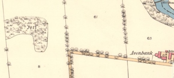
Four cultivation terraces were cut into the eastern slope of a sandy knoll some 366m west of Avonbank Farmhouse. The New Statistical Account refers to Avonbank as one of a series of fortified positions, extending from “Harelaw, by Castlehill to Sighthill “. The source further describes the latter two, on the Avon Valley as “presenting a steep face of some 150ft (46m)… upon which a triple trench had been formed.” The Ordnance Survey Name Book of 1854 states that no fort could be seen, but adds that the tenant of Avonbank Farm removed “an ample supply” of stones from it for building outhouses c1840. The site was destroyed by mineral extraction in the 1990s.
Bibliography
| OSNB | 1854 | SITE OF FORT The site of this fort is situated on a small, wooded elevation, the NE face of which is very steep. The fort formed one of a series of fortified eminencies said to have existed, at some unknown period, along the banks of the River Avon, but no trace of the works are now to be seen. The works of this fort would appear to have been constructed of stone, the present tenant of Avonbank having destroyed it about 15 years since for the purpose of obtaining material, in the shape of stone, to erect out-houses, and from which he obtained an ample supply. |
| NSA Mackenzie, Kenneth; Minister | 1845 | The origin of the most ancient remains in the parish is involved in deep obscurity. They consist of a series of fortified eminences, extending from Harlelaw, near Easter Manuel, by Castlehill, to Sight Hill. The last two present a steep face of about 150 feet in height to the valley of the Avon, upon which a triple trench had been formed, presenting now the appearance of three parallel roads towards the north-east, as if the attack were expected from that quarter. Whether they were raised by the original Celtic inhabitants against Danish invaders from the Lothians, (* Chalmer’s Caledonia) or to retard the advance of the Romans or the Scots towards Camelon, long defended against both, (~ Holinshed) it is impossible now to determine with any certainty. The quantity of stone-coffins found at Linlithgow Bridge, Castle Hill, Sight Hill, and Brakes, on the flanks and in the rear of these defences, leave no doubt that the place was one of carnage. |
| RCAHMS | 1963 | Stirlingshire: An Inventory of the Ancient Monuments. No. 503, p.422. “These terraces lie on the N and E slopes of a sandy knoll which is situated 400 yds W of Avonbank farmhouse and attains an elevation of a little over 200ft O.D. The slight remains of four terraces can be traced; two are close together near the bottom of the slope and the other two, more widely spaced, lie above them. These terraces, described as being at Sighthill, and two adjacent groups are referred to as remains of fortifications in the New Statistical Account. It is possible that this hill was once the site of some sort of defensive structure. In the Ordnance Survey Name Book, after a statement that no fort could be seen at the site, the observations continue: The Works of the Fort would appear to have been constructed of stone; the present tenant of Avonbank having destroyed it about 15 years since for the purpose of obtaining material, in the shape of stone, to erect outhouses; and from which he obtained an ample supply.” 961786 ND 97 NE 8 December 1953. |
| St Joseph, J.K. | 1965 | ‘Air Reconnaissance in Britain, 1961-1964,’ Journal of Roman Studies. p.80 |

