Bothkennar is remarkable insofar as all of the lands there lie on the alluvial plain known as the Carselands. The coastal tract between the River Carron on the south and the Pow Burn on the north was anciently called ‘The Carse of Bothkennar’ and belonged to the Crown Lands known as the Lordship of Bothkennar. Among the feudal duties of the tenants there was the transporting of the royal household between Linlithgow and Stirling. Because it belonged to the crown the records for the area are among the best in Falkirk District. There is widespread belief that until fairly recently these lands were wetlands composed of moss and bog but the records show that arable farming was being practiced there as early as the time of King Robert the Bruce and that the tenants paid their rent with wheat. Wheat only grows on rich soils. The abundance of Gaelic place-names there is a further indicator that the land was occupied and farmed even earlier.
The focal point of Bothkennar was the kirk, the revenues of which were gifted to the nunnery of Eccles at some period before 1265 and these remained in their possession until the Reformation. There was never a village of Bothkennar in the sense we would think of today, only several fermtoons, one of which was on part of lands of Mains of Bothkennar and known as Kirkton. A harbour existed on the banks of the River Carron known as Quarrel Shore and its main purpose is evident in the alternative name Coal Shore which was often applied to it. Following the Industrial Revolution the port was developed by Carron Company and became known as Carronshore. The River was canalised to allow sea going vessels easier passage. The settlement known as Carronshore also grew around it and part of the village lay within the parish of Bothkennar. A small canal, arguably the first in Scotland, connected the harbour with the ironworks and around it developed a variety of ancillary activities including a rope walk, brewery, graving dock, warehouses and a granary. Attached to the granary was Carron House: the most prestigious dwelling in the village and described in 1779 as ‘Mr Gascoigne’s house’. He was a prominent figure in the affairs of Carron Company at that time and had built the house to replace the earlier mansion of Gairdoch. The development of Grangemouth close to the mouth of the Carron led to its demise as a harbour. In that same period a settlement also arose at Skinflats to house the coal miners who worked in the pits there.
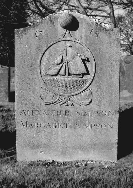
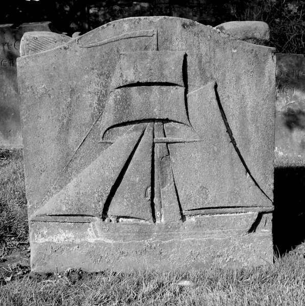
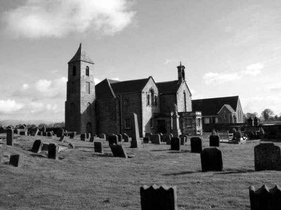
The parish ceased to exist as such and is now a quoad sacra parish under Grangemouth. However, the church, a fine building situated within a pleasant and interesting graveyard, is still used. It was rebuilt in 1789 then remodelled and extended in 1887 but it is evident that substantial parts of the earlier building were incorporated into the new church. Among the grave stones are several embellished with low-relief carvings of sailing ships which commemorate mariners of the parish. There is also a high incidence of cast-iron grave monuments which reflects the importance of the nearby iron foundries.
John Reid (2005)
